Mount St. Helens in 1980
@mountsthelens1980.bsky.social
7K followers 960 following 3.4K posts
Hi there, I’m Chris. Just a guy who is endlessly fascinated by the 1980 eruption of Mount St. Helens (Lawilátɬa/Loowit). #MSH45 About Me: https://bsky.app/profile/mountsthelens1980.bsky.social/post/3lohgbvt4ab2d Links: https://linktr.ee/sthelensin1980
Posts Media Videos Starter Packs
mountsthelens1980.bsky.social
Mariners fans: I'm sorry you have to listen to John Smoltz while watching your team do well on TV.

A jellyfish has more of a personality.
Reposted by Mount St. Helens in 1980
mountsthelens1980.bsky.social
Obviously, I'm pulling for the M's.

Ken Griffey Jr. (and Sr.) were from Donora, down the Mon Valley from Pittsburgh. So was Stan Musial, but that's beside the point.

As a Pirates fan, no ill will exists between our franchises.
pnsn1.bsky.social
You feel that Seattle?! Check out that Polanco P-Wave! Polanco Game Winning Single, Crawford Scores, MARINERS WIN!! @Mariners are Toronto Bound! @Tmobilepark @FoxSports
#SeisTheMoment #SeizeTheMoment
Seismogram showing ground motion at T-Mobile Park for game-winning single by Seattle Mariner Jorge Polanco, JP Crawford scores! MLB poster for PostSEAson 2025 that reads Seis the Moment with a small seismogram between the Seis and the The.  Has website for PNSN seismograms of the game. mariners.pnsn.org
Reposted by Mount St. Helens in 1980
mountsthelens1980.bsky.social
Before it was Mount St. Helens, it was Lawetlat’la—Loowit, the smoking mountain.

To the Cowlitz (Upper Cowlitz/Taidnapam) and Yakama (Klickitat), the volcano is alive—a place of story, balance and renewal.

Today, we honor those who have cared for it since time immemorial. #IndigenousPeoplesDay
View looking south toward Mount St. Helens from the Johnston Ridge Observatory area on August 6, 2017. The wide panorama shows the open crater of the volcano beneath a hazy summer sky, with the North Fork Toutle River valley stretching across the center. Replanted forests and natural regrowth patch the gray landscape of ash and debris left by the 1980 eruption.

Photographed by Chris, August 6, 2017.
Reposted by Mount St. Helens in 1980
mountsthelens1980.bsky.social
Oh, by the way...

┳┻|
┻┳|
┳┻| _
┻┳| •.•) It's "last eruption in 1980" week.
┳┻|⊂ノ
┻┳|
Reposted by Mount St. Helens in 1980
mountsthelens1980.bsky.social
June 1954: The Hoffstadt Creek Bridge is under construction on the then-State Secondary Highway 1R, also known as the Spirit Lake Highway.

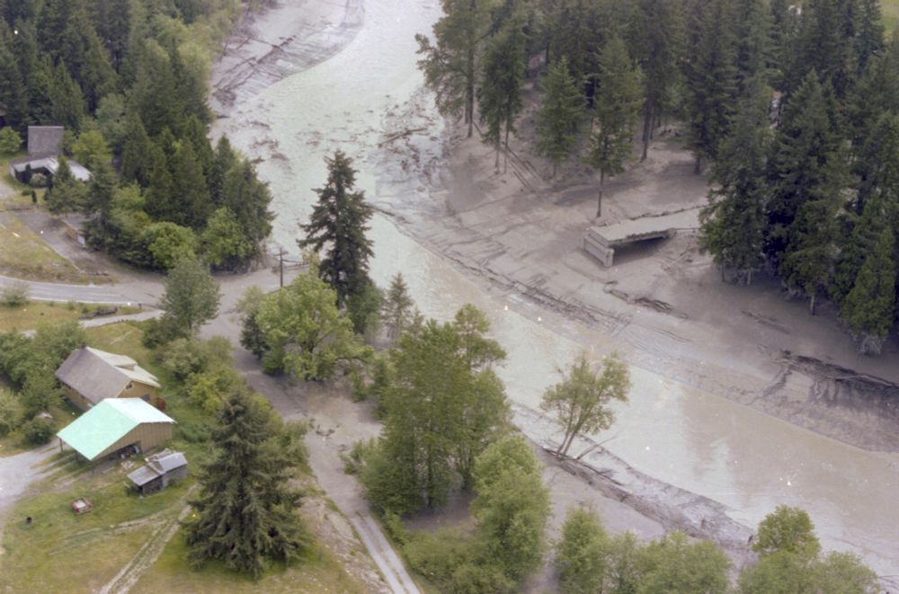
May 1980: Now a part of SR 504, said bridge was practically deconstructed by the lahars of May 18 down the North Fork Toutle.

Sunrise, sunset.
Construction crew placing reinforced steel for the deck slab of the Hoffstedt Creek Bridge, June 1954. The photo looks southeast toward Spirit Lake along Secondary State Highway No. 1-R. The creek, once routed beneath the small bridge visible in the background, was diverted under the new concrete structure as part of the $95,250 Strong & MacDonald contract project.
Washington State Department of Transportation Photograph Collection, June 1954. Aerial view of the Hoffstadt Creek Bridge on State Route 504, taken May 28, 1980. The bridge is almost entirely buried beneath thick mudflow and volcanic debris deposited by the May 18 eruption of Mount St. Helens. Fallen trees and sediment choke the creek channel and blanket the surrounding forest.
Washington State Department of Transportation Photograph Collection, May 28, 1980. Aerial view of the Hoffstadt Creek Bridge on State Route 504, taken May 28, 1980. The bridge is almost entirely buried beneath thick mudflow and volcanic debris deposited by the May 18 eruption of Mount St. Helens. Fallen trees and sediment choke the creek channel and blanket the surrounding forest.
Washington State Department of Transportation Photograph Collection, May 28, 1980.
Reposted by Mount St. Helens in 1980
mountsthelens1980.bsky.social
June 1954: The Hoffstadt Creek Bridge is under construction on the then-State Secondary Highway 1R, also known as the Spirit Lake Highway.

May 1980: Now a part of SR 504, said bridge was practically deconstructed by the lahars of May 18 down the North Fork Toutle.

Sunrise, sunset.
Construction crew placing reinforced steel for the deck slab of the Hoffstedt Creek Bridge, June 1954. The photo looks southeast toward Spirit Lake along Secondary State Highway No. 1-R. The creek, once routed beneath the small bridge visible in the background, was diverted under the new concrete structure as part of the $95,250 Strong & MacDonald contract project.
Washington State Department of Transportation Photograph Collection, June 1954. Aerial view of the Hoffstadt Creek Bridge on State Route 504, taken May 28, 1980. The bridge is almost entirely buried beneath thick mudflow and volcanic debris deposited by the May 18 eruption of Mount St. Helens. Fallen trees and sediment choke the creek channel and blanket the surrounding forest.
Washington State Department of Transportation Photograph Collection, May 28, 1980. Aerial view of the Hoffstadt Creek Bridge on State Route 504, taken May 28, 1980. The bridge is almost entirely buried beneath thick mudflow and volcanic debris deposited by the May 18 eruption of Mount St. Helens. Fallen trees and sediment choke the creek channel and blanket the surrounding forest.
Washington State Department of Transportation Photograph Collection, May 28, 1980.
mountsthelens1980.bsky.social
*Kiedis.

(I don't care, but I have standards to uphold)
Reposted by Mount St. Helens in 1980
mountsthelens1980.bsky.social
Anthony Kedis's first draft of the outro of Under the Bridge:

Under the bridge, lahar.
Cabin was washed away.
Under the bridge, lahar.
Bridge didn’t last the day.
Reposted by Mount St. Helens in 1980
mountsthelens1980.bsky.social
#MSH45 | May 18, 1980
KATU Portland films a cabin drifting down the Toutle River from Hollywood Gorge—floating, spinning in a brown slurry.

Downstream, it hits Tower Road Bridge—30 miles from Mount St. Helens.

By morning, the bridge itself was gone.
mountsthelens1980.bsky.social
Closer to the crater, you say?

CLOSER!
ChatGPT said:

Vertical aerial view of Mount St. Helens’ crater, October 15, 1980. The photo captures the steep inner walls and developing lava dome at the crater floor, emitting wisps of steam. Surrounding slopes are blanketed in ash and pyroclastic material from months of eruptive activity following the May 18 event.
Washington State Department of Transportation Aerial Photolab, October 15, 1980.
mountsthelens1980.bsky.social
Let's take to the skies on Oct. 15, 1980, as a @wsdot.wa.gov camera gives us a top-down view of Mount St. Helens.

A quiet mountain, for the moment.
Vertical aerial view of Mount St. Helens on October 15, 1980, five months after the eruption. The image looks directly down into the then-newly formed crater, where steam rises from the nascent lava dome. The mountain’s northern flank is sheared away.
Photographed by Washington State Department of Transportation, October 15, 1980.
mountsthelens1980.bsky.social
Oh, by the way...

┳┻|
┻┳|
┳┻| _
┻┳| •.•) It's "last eruption in 1980" week.
┳┻|⊂ノ
┻┳|
mountsthelens1980.bsky.social
Anthony Kedis's first draft of the outro of Under the Bridge:

Under the bridge, lahar.
Cabin was washed away.
Under the bridge, lahar.
Bridge didn’t last the day.
mountsthelens1980.bsky.social
Hey, let's go hang out at the washed-out bridge.

Sure.
View of the destroyed Tower Road Bridge over the Toutle River in Cowlitz County, July 7, 1980. The bridge’s main span has been swept away by lahars from Mount St. Helens, leaving only the central pier and abutments surrounded by eroded mudflow deposits. Several people stand on the remaining structure and riverbank, examining the extent of the damage.
Photographed by Robert L. Schuster, U.S. Geological Survey, July 7, 1980.
mountsthelens1980.bsky.social
May 19, 1980.

The green Tower Road bridge is a thing of the past.
Aerial view of the Tower Road Bridge over the Toutle River on May 19, 1980, one day after the Mount St. Helens eruption. The bridge’s main span has been washed away by mudflows, leaving only the western approach intact. Nearby homes sit beside a river thick with sediment and volcanic debris, the surrounding landscape blanketed in gray ash and silt.
Photographed by GB, Washington State Department of Transportation.
mountsthelens1980.bsky.social
#MSH45 | May 18, 1980
KATU Portland films a cabin drifting down the Toutle River from Hollywood Gorge—floating, spinning in a brown slurry.

Downstream, it hits Tower Road Bridge—30 miles from Mount St. Helens.

By morning, the bridge itself was gone.
Reposted by Mount St. Helens in 1980
mountsthelens1980.bsky.social
#MSH45 | May 18, 1980
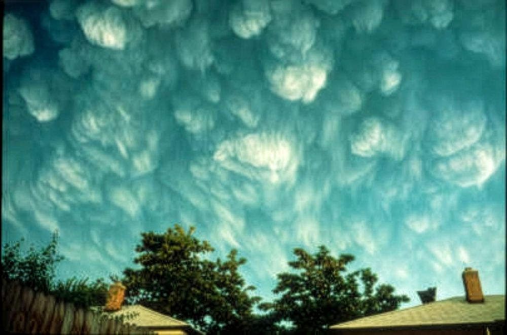
"Now that's an ash cloud."
— Paul Hogan, "Crocodile Dundee," when looking at a photo of the mammatus clouds of volcanic ash over Richland, Washington.
Volcanic ash clouds from the eruption of Mount St. Helens form mammatus-like patterns in the sky over Richland, Washington, more than 180 miles east of the volcano. Photographed by Don J. Easterbrook, University of Washington Libraries, Special Collections (Donald J. Easterbrook Photograph Collection, PH Coll 797, image EAS1008).
mountsthelens1980.bsky.social
What I haven't heard: "Yeah, so the mountain erupted and I saw the ash cloud and I felt literally nothing about it—went back about my day, big friggin whoop."
mountsthelens1980.bsky.social
Some of the best parts of these last 10 months have been hearing people's recollections.

They're all captured by the awe of the moment, but then they go about their lives and jobs, whether or not it was impacted directly. But they all have that moment of powerless awe.
mountsthelens1980.bsky.social
Hey, there's no parasocial issues here, friend.

This is an open space. I hid and was ashamed of my enthusiasm for this for far too long, and opening up and seeing posts like yours keeps me—and all of us—going.

Pretty cool that the county seat of Skamania has something about it!
Reposted by Mount St. Helens in 1980
casualruffian.bsky.social
But I'd already taken a pic so here it is
A museum display of commemorative jars and bags of Mt St Helens volcanic ash. The labels and jar tops all have a blue & white theme