Neil Lareau
@neillareau.bsky.social
1.4K followers 74 following 97 posts
Prof. of Atmos Sci. @unevadareno. Mountain WX, Wildfire Plumes, Backcountry Skiing, Frontcountry Dadding. Formerly: @SJSUmeteorology @UUtah @Livermore_Lab @MWObs https://scholar.google.com/citations?user=UGaGnAgAAAAJ&hl=en
Posts Media Videos Starter Packs
Reposted by Neil Lareau
edwardsanthonyb.bsky.social
Water levels are fluctuating rapidly as the tsunami hits Midway Island, 1,200 miles northwest of Hawaii... wow.
neillareau.bsky.social
Diverting money from science funding for immigration crack downs is dumb. Science funding provides enormous ROI. Deporting & intimidating unauthorized immigrants undermines the functioning and growth of our economy. In other words, you spend money to lose money, or negative ROI.
Reposted by Neil Lareau
mikeflannigan.bsky.social
Updated figure from Jain et al. showing global extreme fire weather trends since 1979. Metrics are global 95th percentile of annual Fire Weather Index (FWI), Initial Spread Index (ISI) and the Vapor Pressure Deficit (VPD). The trend is clear - we are seeing more extreme fire weather due to warming.
graphs showing fire weather index (FWI), initial spread index (ISI) and vapour pressure deficit (VPD) 95th percentile trends 1979 to 2024. Updated from Jain et al. 2022 https://www.nature.com/articles/s41558-021-01224-1
neillareau.bsky.social
And to be clear, it still would not be likely that you could match the really fast tsunami wave speed in lake tahoe with a squall line's forward speed...
neillareau.bsky.social
My evolving understanding of these though is that even for a small pressure perturbation if the propagation speed of the pressure induced wave (i.e, c=sqrt(gH)) is phase locked with the gust front then you keep pumping (wind stress) energy into it and build a bigger wave?
neillareau.bsky.social
There is something screwy with the time stamps, but I’m 99% sure that is the correct interval
neillareau.bsky.social
Here is the high resolution pressure data, showing a 3 mb increase in pressure consistent with the dropping temperature (e.g., hydrostatic pressure change due to the cold frontal passage).
neillareau.bsky.social
But I really don't know how coupled lake and wind dynamics work beyond... so please educate me if any of ya'll have insights.
neillareau.bsky.social
6/n: However, Lake Tahoe is really deep, so the shallow water gravity wave speed is really fast (>50 m/s), so unlikely there is resonance between a propagating wave in the lake and the gust front...
neillareau.bsky.social
5/n: The winds alone are strong (44 mph), but not severe. The wave response, in contrast is quite notable. It has me wondering about the "meteotsunami" phenomenon (agupubs.onlinelibrary.wiley.com/doi/full/10....). This is pure speculation and I'd be keen to here a deeper background on the topic.
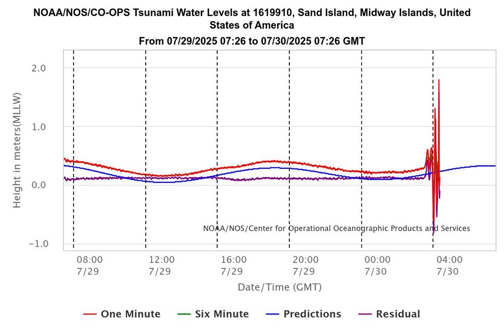
Meteotsunami occurrences and causes in Lake Michigan
Water level records indicate that meteotsunamis occur throughout the Lake Michigan basin Pareto family distributions describe size-frequency character of meteotsunamis Convective and frontal system...
agupubs.onlinelibrary.wiley.com
neillareau.bsky.social
4/n: Next up are wave data. This plot from TERC, shows that the wave heights follow a pattern similar to the wind ramp on 6/21, suddenly reaching above 1 m. The abrupt increase in way height is really an alarming signal.
neillareau.bsky.social
3/n: The corresponding temperature data show a sharp drop in temperature consistent with the frontal passage enhanced by diabatic cooling (evaporation) beneath the thunderstorms and stratiform rain/snow.
neillareau.bsky.social
2/n: Now lets look at the buoy weather station data over the center of the lake, first the wind speed, which shows relatively calm winds during the morning, then a sudden wind ramp followed by ~1.5 hrs of strong winds as high as 20 m/s (~44 mph). [the time stamps on these plots are wrong...]
neillareau.bsky.social
1/n: Still trying to understand the Lake Tahoe boating disaster from this past weekend. I like letting the data lead. Lets start with the radar, where I've added a red line annotating the clear, coherent wind shift associated with the front sagging south across the region.
neillareau.bsky.social
It’s so frustrating to have had this beautiful organic way of accessing primary source intel… lost now to ego of a billionaire…
Reposted by Neil Lareau
wisc-satellite.bsky.social
Visible & Infrared images from #GOES19/#GOESEast showed that the #TroutFire in New Mexico produced a #pyrocumulonimbus (pyroCb) cloud on 14 June - the first pyroCb in the US for the 2025. More on the CIMSS Satellite Blog: cimss.ssec.wisc.edu/satellite-bl... H/T @neillareau.bsky.social
neillareau.bsky.social
That’s a very windy spot!
Reposted by Neil Lareau
mparrington.bsky.social
Total estimated emissions of 2025 Canadian #wildfires to 03/06 at ~50 MtC, comparable to 2023 record over same period, and increasing. #CopernicusAtmosphere Global Fire Assimilation System data based on MODIS🛰️ active fire obs ads.atmosphere.copernicus.eu/datasets/cam... @copernicusecmwf.bsky.social
neillareau.bsky.social
More from today’s Rx burn:
neillareau.bsky.social
Good day for good fire in #Truckee!
neillareau.bsky.social
As noted by NRL's Mike Fromm, another exceptional #PryoCB today in Saskatchewan this afternoon.
Reposted by Neil Lareau
cira-csu.bsky.social
Robust plumes of pyrocumulonimbus billow from wildfires in Alberta.

These were among many wildfires exhibiting extreme behavior yesterday across Canada.