Phil Ferro
@pferrowxman.bsky.social
170 followers 110 following 1.5K posts
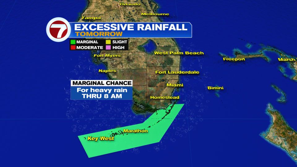
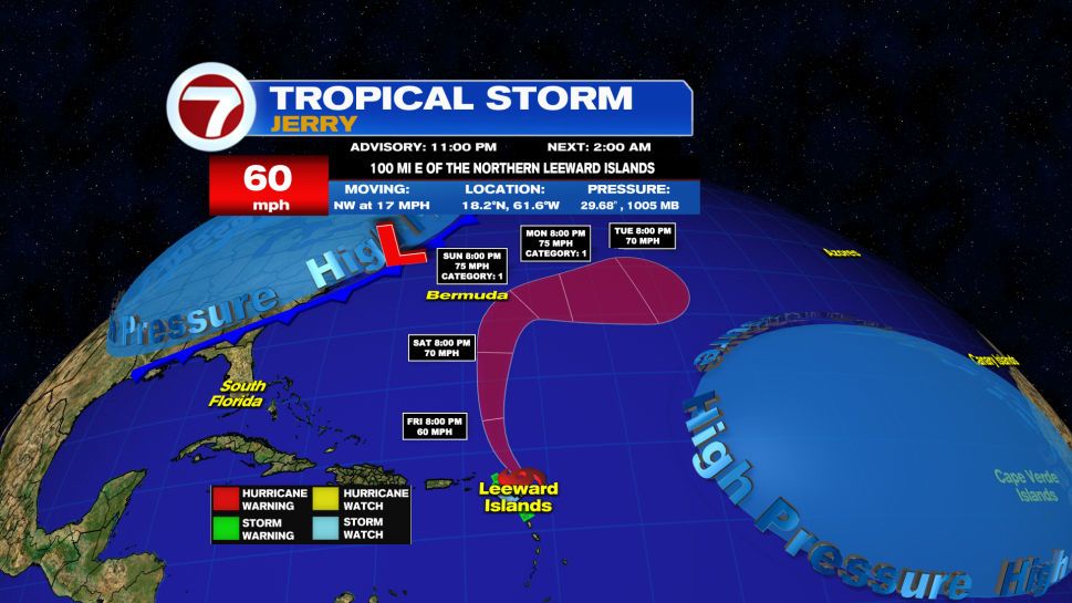
Tropical updates, to So FL weather. Chief Meteorologist at WSVN TV Miami FL. 2 x Emmy award winner.
Posts Media Videos Starter Packs
pferrowxman.bsky.social
9:30 pm Rain Update:
🔴After a quiet evening, another line of rain is developing over inland Broward & moving East. May arrive over the next hour.
🔴Miami-Dade could see overnight showers.
🔴The Strait's rain is weakening & moving NE. More may impact the Keys thru Sat a.m.
pferrowxman.bsky.social
Karen Shortest Lived System? NHC does not keep track of this category. We dug into their files and found some quick ones. Karen developed at 11pm Thursday, it was done by 5 pm Friday. There may be more examples in their archives.
Image 1 Image 2
pferrowxman.bsky.social
And it continues to come down by the Keys. Marathon's total is now up to 5.20" - a record. More rain is possible thru tomorrow afternoon.
Image 1
pferrowxman.bsky.social
The Florida Keys will remain under a Coastal Flood Advisory until Saturday morning. Low lying areas could see more standing water from King Tides.
Image 1
pferrowxman.bsky.social
The Coastal Flood Advisory for Broward & Miami-Dade has been replaced with a Statement. This means instead of a good probability for high water, there will be only a slight chance. This will remain in place thru Sunday.
Image 1
pferrowxman.bsky.social
Although we've already passed the peak of this current King Tide cycle, a couple more days of high water will be possible.
Image 1
pferrowxman.bsky.social
The Potential for Excessive Rainfall will remain for the Florida Keys until 8 a.m. Saturday.
Image 1
pferrowxman.bsky.social
RECORD RAIN in Marathon this Friday. The old total was 1.44" from 1994.
Image 1
pferrowxman.bsky.social
5 pm Advisories on Jerry & Karen. Jerry is not forecast now to reach hurricane strength. It should stay away from Bermuda. Karen- As fast as it developed, it fell apart. Subtropical Storm Karen is done. NHC wrote the last advisory at 5 pm.
Image 1 Image 2
pferrowxman.bsky.social
After the passage of a Fall Front, we should dry out. Until it clears the area, we will still see some rain Saturday. From Sunday onwards, it's looking mostly rain free.
Image 1
pferrowxman.bsky.social
Downpours persist across the many areas in the Keys. More is sitting over the Straits aiming for the Island Chain. Could be a very soggy evening.
Image 1
pferrowxman.bsky.social
A front moves thru Saturday across So FL. There will still be a chance for a few downpours. The front is forecast to clear the area by Sunday. Typical temps will be the norm, with lower humidity values, & drier weather. A complete update on WSVN 7 & ABCMiami
Image 1 Image 2 Image 3
pferrowxman.bsky.social
Rain totals since last night. It's still pouring in parts of the Keys. Their totals will continue to rise through the evening hours.
Image 1
pferrowxman.bsky.social
As of 11 pm Thursday, Tropical Storm Jerry has its winds come down from 65 mph to 60. Some rain is impacting the Leeward Islands. It is not that healthy, but NHC says it still has a chance to become a hurricane down the road.
Image 1 Image 2
pferrowxman.bsky.social
NEW as of 11 pm Thursday. Subtropical Storm Karen. It is a minimal system and a concern for the shipping lanes. A subtropical system tends to have its rain removed from the center, and that is what we have here. It should be short lived.
Image 1 Image 2 Image 3
pferrowxman.bsky.social
A strong earthquake rattles the Philippines. 7.4 on the intensity scale. This is capable of serious damages to structures. No Tsunami Threat as of this hour.
Image 1
pferrowxman.bsky.social
While Jerry remains disheveled, most of its rain is dragging south of the center. Some of the islands getting downpours and some gusty winds. Tropical Storm Watches & Warnings remain in place for the Leeward Islands.
pferrowxman.bsky.social
Thursday Evening Trop. Storm Jerry Advisory & Cone: It remains disorganized with most rain to the SE. Trop. Storm Watches & Warnings remain in place for the Leeward Ils., The center should stay away from them. Still some gusty winds & rain is forecast there.
Image 1 Image 2
pferrowxman.bsky.social
Thursday Evening Tropical Update: T.S. Jerry, stays w 65 mph winds. A disturbance near Mexico watched yesterday, has moved onshore Coastal Mexico. Area #3, Invest 96L has its chances for development skyrocket from 10% this afternoon to 60% tonight.
Image 1
pferrowxman.bsky.social
Enhanced Satellite: Bubbling clouds suggest where storms are found within Trop. Storm Jerry. Most of the activity is sitting East of the Center. Over the last 6 hours it has taken more of a Northwest turn. Hoping the worst stays away from the islands.
pferrowxman.bsky.social
The Weather Prediction Center suggests that with a front moving into So FL trapping moisture over the area, it could lead to heavy rain. A marginal chance for excessive rain is possible on Friday over highlighted area.
Image 1
pferrowxman.bsky.social
6 pm Thursday Radar Look: Scattered downpours moving onshore across Broward & Miami-Dade. Upper Keys with a Train of Rain traveling toward the Upper Keys. More showers are possible tonight.
Image 1 Image 2
pferrowxman.bsky.social
A front is forecast to move over So FL Friday thru Saturday. Both GFS & EURO models are forecasting possible heavy downpours Friday with a few lingering storms Saturday. Mostly dry afterwards. Our First Taste of Fall Florida Style.
Image 1 Image 2
pferrowxman.bsky.social
5 PM Thursday Tropical Storm Jerry Advisory & Cone: Stays w 65 mph winds. Impacts from the storm will be felt outside the cone of concern. Winds over 39 mph are possible across the Leeward Islands. Storm Watches & Warnings are in place there,
Image 1 Image 2
pferrowxman.bsky.social
While the King Tides are lessening, there will still be some salt water flooding of low lying areas. Here are your next High Tide Times
Image 1