Andrew Tyrrell
@southarrowmaps.co.nz
1.1K followers 340 following 150 posts
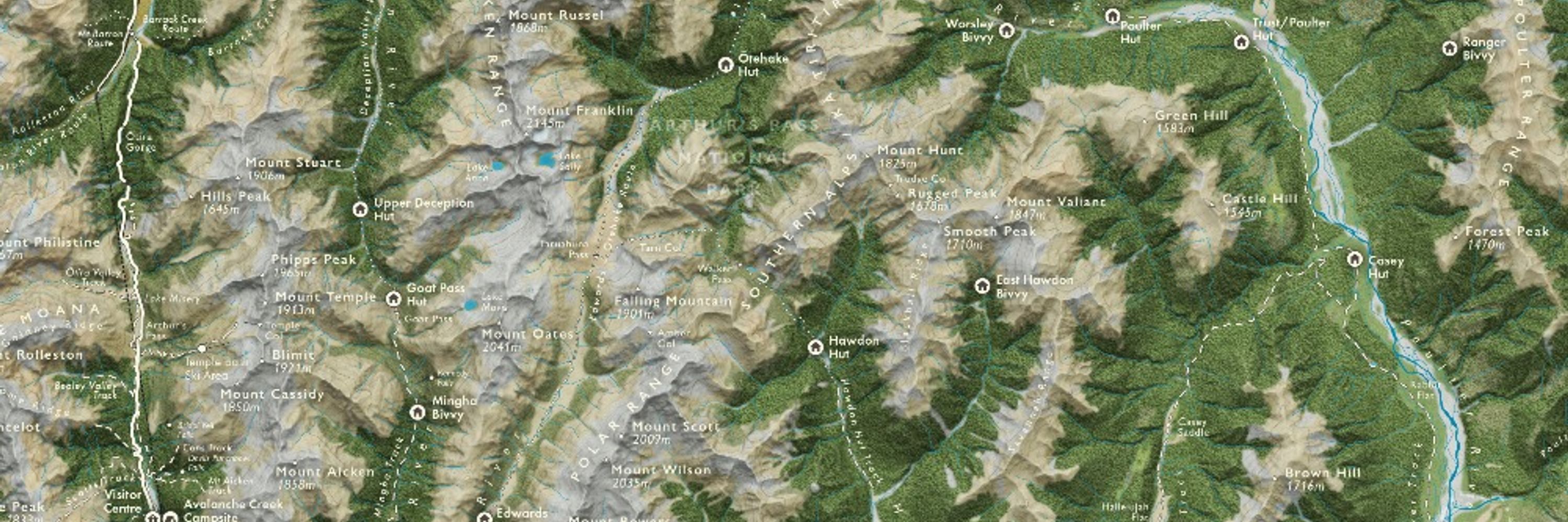
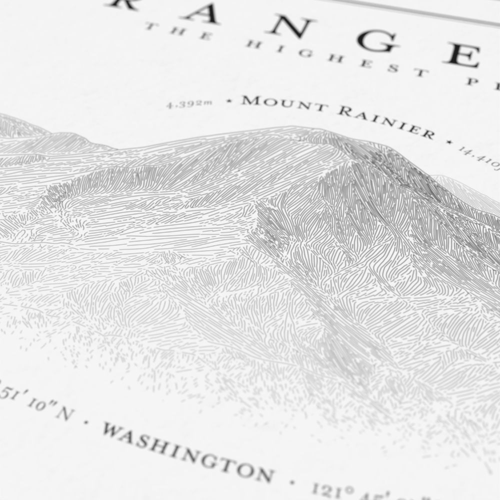
🗺🇳🇿🇨🇦🏔 NZ-based cartographer, actually now Canada-based. Blender, QGIS, ArcGIS Pro, Illustrator. Partial to a good mountain. southarrowmaps.co.nz
Posts Media Videos Starter Packs
Pinned
southarrowmaps.co.nz
I'm off to #Canada 🍁 and I'm looking for #jobs!

I'm looking for roles in BC/AB in or around #Vancouver / #Calgary / Canadian #Rockies / remote.

Open to anything #GIS & #cartography.
11+ years experience across ArcGIS, QGIS, FME, Adobe, Blender…

Please get in touch if you have any leads!

#gischat
A simple greyscale map showing New Zealand in the lower left, and Canada in the upper right. A large curved arrow leads from the former to the latter
southarrowmaps.co.nz
Beyond gutted that I couldn’t make it to #NACIS2025 this year, not only because I’m missing out on seeing some amazing #cartography presentations, but more because I’m missing out on meeting the new mappy friends I made last year!
Reposted by Andrew Tyrrell
thebasement.nz
I’ve just finished my full-scale topographical map of the Himalayas and that’s a huge relief, I can tell you
Reposted by Andrew Tyrrell
pinakographos.bsky.social
New poster! Hachure illustrations of the highest Cascade Range volcanoes. This one took a lot of experimentation to get the layout right. If you or someone you know loves this area, check it out. www.etsy.com/listing/4373...
A black and white illustration titled "Cascade Range Volcanoes," showing a 3 by 3 layout of the nine tallest peaks in the range. The art is done in a hachure sketch style. A detail image of the illustration of Mount Rainier A detail image from the poster of Mounts Hood and Jefferson.
Reposted by Andrew Tyrrell
pinakographos.bsky.social
The Alliance of Freelance Cartographers has a new website! Thanks to @alyolli.bsky.social for getting it off the ground. It hosts past editions of the survey, as well as other resources. www.freelancemaps.org/home
A screenshot of the AFC website
southarrowmaps.co.nz
I miss having a three-screen 4K setup, but a two-screen 1080 setup that fits in a little laptop bag and runs off a single power socket is pretty neat for my current van-life
southarrowmaps.co.nz
I’m surrounded by stunning, dramatic landscapes, yet I’m sat in Squamish Public Library hand-drawing* a map of Mt Cook…

(*tracing from reference)
A photo of my tiny desk setup in Squamish Library. There’s my laptop, with an image and a QGIS window sharing the screen, and in the foreground is my graphics tablet displaying Adobe Illustrator. I’m poised with the stylus, tracing the historical extent of Haupapa/Tasman Glacier
southarrowmaps.co.nz
I love the map, the timeline, the debunking of a myth, and the face that the myth even exists.
10/10, would Storrow again
awoodruff.bsky.social
Since Boston is sounding the “don’t drive a truck on Storrow” sirens this week, time to post this map again, now with a timeline.

As far as I can tell, either the messaging works or the idea of students smashing U-Hauls into overpasses is largely a myth. I couldn’t find any real spike in September.
Map showing number and locations of crashes involving vehicles striking overhead bridges or signs on Storrow Drive and Memorial Drive in Boston and Cambridge, Massachusetts.
southarrowmaps.co.nz
#MapsInTheWild

Southern Vancouver Island, the Gulf Islands, and the Juan de Fuca Strait, in a compass in the ground in Victoria, BC
A photo of the centre part of a compass embedded in the ground. The middle has a brass map of the southern part of Vancouver Island, the Gulf Islands, and the Juan de Fuca Strait.
southarrowmaps.co.nz
My time at #ICC2025 in Vancouver has come to an end.
This morning I was the secondary delegate representing New Zealand at the 20th General Assembly of the International Cartographic Association, voting to approve Warsaw as the hosts of #ICC2027.
Might see you there!
A photo of me sitting at a table behind a sign reading “Nouvelle-Zélande”, as one of the delegates representing New Zealand at the 20th General Assembly of the International Cartographic Association. The two official languages of the ICA are English and French, hence the country name. “New Zealand” is written on the other side. A photo from my point of view of the General Assembly, showing the country name card “New Zealand”, with many other rows of delegates
Reposted by Andrew Tyrrell
kennethfield.bsky.social
The Indonesians have brought their spectacularly talented kids to #ICC2025 again. Yes, this is my biennial sarcastic children's map competition post. Four. Years. Old... FOUR!!! Do me a favour 🤦🤣🤣🤦🤣
southarrowmaps.co.nz
The Belgian ones are dark…
A map from the 2025 Children’s Map Competition, showing the world covered in smoke-emitting factories/nuclear reactors, with the title “DO SMTHG” and the text “THE WORLD WILL FALL APART” A map from the 2025 Children’s Map Competition, showing the world split diagonally from SW to NE. The SE half shows green vegetation, and land and marine animals. The NW half is bare and desolate, with deforestation and pollution, and an image of Trump whistling, Putin holding a gun, and Zelenskyy hiding behind an EU flag. The title is “Roll out the fallout”
southarrowmaps.co.nz
Posted without comment
A photo of a slide from a presentation. Against a white background is the title “ICC2025: Rainbow color scheme”, below which is a rainbow colour scheme.
southarrowmaps.co.nz
At this scale you can basically see @johnnelsonmaps.bsky.social’s garden shed office
A giant floor map of the Great Lakes/St Lawrence watershed, laid out at ICC2025.
southarrowmaps.co.nz
We may have all pointed and laughed, but we all also provided many suggestions for improvement
southarrowmaps.co.nz
I thought we’d collectively agreed that just pointing and laughing at people’s “bad” maps, without offering constructive advice for improvement, was something that we’d confined to the regrettable past?
southarrowmaps.co.nz
You know it’s gonna be a great day of maps when it starts with The Pirates!
southarrowmaps.co.nz
They’re stunning!
southarrowmaps.co.nz
@chaneyswiney.com are these yours? Spotted in the #ICC2025 Map Gallery
Six stunning “peakscapes”, showing oblique depth maps of notable mountains/ranges with beautiful colour ramps
southarrowmaps.co.nz
I knew Canada was big but this is ridiculous…
The author, stood on the giant Indigenous Peoples Atlas of Canada
southarrowmaps.co.nz
All the way up to 11! Mesmerising.

Anyway, what were you saying?
southarrowmaps.co.nz
I didn’t listen to a word of @kennethfield.bsky.social’s #ICC2025 talk.
I was fixated on working out if the tonearm and volume dial on his record player were moving through the 15min talk, or if I was just imagining it.

I s’pose not listening to a talk is kind of breaking the rules of a conference…
A photo of a presentation slide. The left side shows the cover of Judas Priest’s “Breaking the Law”, while the right side shows a top down view of a record player with the aforementioned record spinning.
southarrowmaps.co.nz
I thought discussions got heated when cartographers try to define what is and isn’t considered a “map”.

I’ve just spent three hours in a room of cartographers discussing what is and isn’t considered an “atlas”…

I need a beer…
southarrowmaps.co.nz
Let’s do this!

#ICC2025
The author, posing awkwardly with his name badge, in front of a banner reading “Welcome to the 32nd International Cartographic Conference”
southarrowmaps.co.nz
Let’s do this!

#ICC2025
The author, posing awkwardly with his name badge, in front of a banner reading “Welcome to the 32nd International Cartographic Conference”