Weatherlogics πŸ‡¨πŸ‡¦
banner
weatherlogics.bsky.social
Weatherlogics πŸ‡¨πŸ‡¦
@weatherlogics.bsky.social
260 followers 140 following 34 posts
Your Canadian weather and road conditions app. Download Weatherlogics for iOS and Android.
Posts Media Videos Starter Packs
Reposted by Weatherlogics πŸ‡¨πŸ‡¦
Hail is a major source of insured losses in Canada; it is also responsible for significant agricultural yield losses. In this recent #JCRR paper, authors Scott Kehler and Matthieu Desorcy, @weatherlogics.bsky.social, explore methods to produce a reliable #hail #climatology: buff.ly/QrFqvOM
The first snowfall of the season is expected tomorrow in parts of Saskatchewan and Westman. Here is a map showing total predicted snowfall amounts on Sunday. Note: The depth of snow on the ground may be less than forecast because there will be some melting. #mbstorm #skstorm
Reposted by Weatherlogics πŸ‡¨πŸ‡¦
An early frost event occurred in Saskatchewan this morning. Numerous low temperatures were around or just below the freezing mark:

Indian Head: -0.6 C
Yellow Grass: 0.2 C
Coronach: 0.6 C
Broadview: 1.1 C
Estevan: 1.0 C
Weyburn: 2.2 C
Regina: 2.3 C
Moose Jaw: 2.4 C
We are excited that our peer-reviewed and report-based hail climatology for Canada has been published in the The Journal of Catastrophe Risk & Resilience. The climatology shows a maximum in hail occurrence along the Alberta foothills with secondary maxima in the BC interior and southern Prairies.
There is a risk of severe thunderstorms today in southeastern Saskatchewan and southwestern Manitoba. Any storms this evening also have the potential to produce tornadoes.
Reposted by Weatherlogics πŸ‡¨πŸ‡¦
A much-needed rain event brought significant amounts to northern MB over the past couple days. Here are some storm totals:

Lynn Lake: 84.7 mm
Pukatawagan: 58.8 mm
La Ronge, SK: 54.6 mm
Tadoule Lake: 27.0 mm
Thompson: 23.9 mm
Snow Lake: 18.7 mm
The Pas: 18.4 mm
Flin Flon: 18.2 mm
There is a risk of severe thunderstorms today in parts of Alberta and Saskatchewan, including the possibility of a tornado. Our outlook below shows the severe risk area in yellow.
There is a risk of isolated severe thunderstorms in southern and central Manitoba beginning this afternoon and continuing into tonight. This includes the potential for tornadoes in south-central Manitoba. Be prepared if severe weather approaches!
Isolated severe thunderstorms are possible today across parts of Saskatchewan and Manitoba. Below is our severe-weather outlook, with the risk area shaded in yellow. A chance of tornadoes has been identified within the white, cross-hatched area.
Here is our latest rainfall prediction for the Prairies, covering today through Saturday morning. Southeastern Saskatchewan and western Manitoba are expected to receive the most rain, but there should also be some precipitation over the fires in southeastern Manitoba!
We’ve just sent a significant weather update to our agriculture subscribers in Manitoba and Saskatchewan, detailing the extreme heat expected this weekend and the timing of the next chance of rain. Check your inbox for more information!
Reposted by Weatherlogics πŸ‡¨πŸ‡¦
Imagery from the Sentinel-2 satellite on Tuesday showed a lot of ice remaining over the Manitoba lakes. However, much warmer temperatures will arrive starting tomorrow, so that ice won't be around much longer!
Stay one step ahead of the weather with Weatherlogics’ high-resolution rainfall mapsβ€”see yesterday's showers and tomorrow’s downpours right down to your field.

Learn more: www.weatherlogics.com/agriculture/
With spring upon us, we've wrapped up our snowfall and road condition maps for the season. However, you can always stay updated with our latest forecasts and real-time road conditions in our app. Rest assured, we'll continue to monitor any severe weather that may develop this spring and summer!
Agriculture Feature: Virtual Weather Stations

The Weatherlogics Virtual Weather Station automatically monitors detailed weather conditions at your farm without the need to install any hardware.

To learn more, or get a free trial, just visit our website:

www.weatherlogics.com/agriculture/
A significant spring snowstorm is coming to an end across the Prairies. Here are estimated total snowfall amounts across the region up to 12 PM on Friday, March 28. #abstorm #skstorm #mbstorm
At Weatherlogics, we’re proudly Prairie-based and deeply understand the weather challenges you face.

βœ… Accurate, actionable forecasts tailored for your farm
βœ… Designed specifically to support your critical farming decisions

πŸ‘‰ Sign up for a FREE trial: www.weatherlogics.com/agriculture/
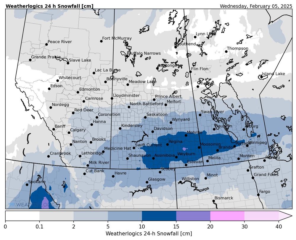
Here is our snow forecast map for tomorrow - Wednesday, February 05, 2025. For a more detailed local forecast, download Weatherlogics in the app store.
Weatherlogics is a proudly Canadian company! We are redoubling our commitment to bringing high-quality weather information to every corner of our great country.
Most major highways are closed in southern Manitoba due to the ongoing blizzard. To check weather and roads in your area, download our free app (links below):

iOS: apps.apple.com/us/app/weath...
Android: play.google.com/store/apps/d...
It appears that is a marine watch, which you can find on the marine forecast page of the ECCC website.
πŸ“£ Exciting News from Weatherlogics!

We’re thrilled to unveil our brand-new logo and a fresh, redesigned website!

Explore the updated look and experience the innovation we bring to weather. Check it out at: www.weatherlogics.com