


Ed Farrell
@edfarrell.bsky.social
Liverpool history enthusiast and artist
Well spotted. And no support/brickwork visible through the archway. Here and in Shaw the tower itself seems too slender to hold tanks. R.S. Fitzgerald has some great bridge/station detail. Nothing on this - though "the Navigation Company was to be provided with an 18ft cartway across the bridge".

December 8, 2025 at 8:49 PM
Well spotted. And no support/brickwork visible through the archway. Here and in Shaw the tower itself seems too slender to hold tanks. R.S. Fitzgerald has some great bridge/station detail. Nothing on this - though "the Navigation Company was to be provided with an 18ft cartway across the bridge".
Thanks very much for this Paul. I guess all will be South assuming Vignoles off calc was consistent? Just beginning a refined version of Lpool Street; will come back to this. Walker and others good on describing the Lpool to Mcr route and e.g. your point on no bridge at Wavertree Lane! .
December 8, 2025 at 2:13 PM
Thanks very much for this Paul. I guess all will be South assuming Vignoles off calc was consistent? Just beginning a refined version of Lpool Street; will come back to this. Walker and others good on describing the Lpool to Mcr route and e.g. your point on no bridge at Wavertree Lane! .
Yes, you are right Vrs. Interesting at least to see the OS conventions through. Here are some examples on site of support structures within an underpass - walls/columns etc. Assuming consistency.
Sometimes these problems simply end up being a scientific guess in the absence of supporting images.
Sometimes these problems simply end up being a scientific guess in the absence of supporting images.

December 7, 2025 at 5:07 PM
Yes, you are right Vrs. Interesting at least to see the OS conventions through. Here are some examples on site of support structures within an underpass - walls/columns etc. Assuming consistency.
Sometimes these problems simply end up being a scientific guess in the absence of supporting images.
Sometimes these problems simply end up being a scientific guess in the absence of supporting images.
But does show a division for the pedestrian v road underpass.
December 7, 2025 at 4:31 PM
But does show a division for the pedestrian v road underpass.
Thanks very much for this VRS; suggesting a casing of some kind spanning somewhere along the width of the cistern?. I'm still trying to work out which part of the structure corresponds with the water tower/chimney seen in Bury. If indeed it still exists in its original form.
December 7, 2025 at 4:04 PM
Thanks very much for this VRS; suggesting a casing of some kind spanning somewhere along the width of the cistern?. I'm still trying to work out which part of the structure corresponds with the water tower/chimney seen in Bury. If indeed it still exists in its original form.
James Scott Walker - An Accurate Description of the L&MR
December 7, 2025 at 11:40 AM
James Scott Walker - An Accurate Description of the L&MR
Thanks so much David, more soon!...
December 6, 2025 at 9:55 PM
Thanks so much David, more soon!...
Hi David, thanks and great! Just need to go through some settings process to access messaging apparently.. ??
December 6, 2025 at 9:54 PM
Hi David, thanks and great! Just need to go through some settings process to access messaging apparently.. ??
Haha! Yes, but still, amazing.
December 4, 2025 at 10:56 PM
Haha! Yes, but still, amazing.
This seems convincing to me
December 4, 2025 at 10:15 PM
This seems convincing to me
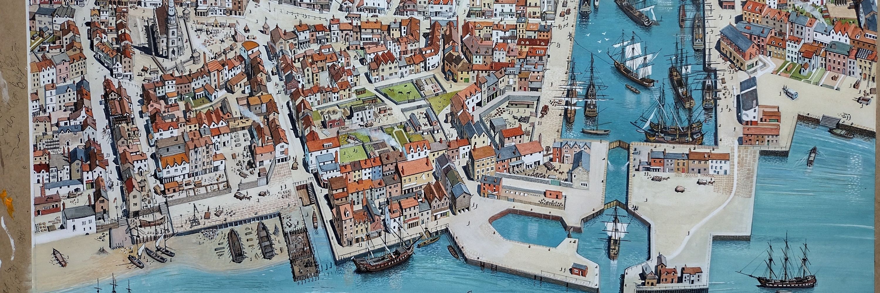
Oh this is really great Vrs. Vivid and really brings it to life! You've got the Water St. end too. The past emerging from the mist, very exciting. I wonder if the interior was just a big space?
December 4, 2025 at 9:47 PM
Oh this is really great Vrs. Vivid and really brings it to life! You've got the Water St. end too. The past emerging from the mist, very exciting. I wonder if the interior was just a big space?
Thanks so much for this Urs! And hi to David!
December 4, 2025 at 12:13 AM
Thanks so much for this Urs! And hi to David!
Thanks so much Paul!
December 3, 2025 at 11:53 PM
Thanks so much Paul!
Thanks Ant. The maps Iv e seen so far of the 'new' arrivals station are fairly blocky. So had a first shot at imagining it from OS entirely speculatively! Is there some detail somewhere?

December 3, 2025 at 12:23 PM
Thanks Ant. The maps Iv e seen so far of the 'new' arrivals station are fairly blocky. So had a first shot at imagining it from OS entirely speculatively! Is there some detail somewhere?
Yes, I agree very much Ant. The process needs some source 'triangulation,' I guess to get closer pictorially to the truth than we currently have and to make a view that is somehow more open book and accessible. If that doesn't sound too pretentious!
December 3, 2025 at 10:12 AM
Yes, I agree very much Ant. The process needs some source 'triangulation,' I guess to get closer pictorially to the truth than we currently have and to make a view that is somehow more open book and accessible. If that doesn't sound too pretentious!
Thanks for this piece of work Paul, its great. The schedule of bridges is an amazing resource!. I think I'll need to do a road name comparison to understand the overlay better and make adjustments. Line crossing images are relatively few so cheers.
December 3, 2025 at 9:14 AM
Thanks for this piece of work Paul, its great. The schedule of bridges is an amazing resource!. I think I'll need to do a road name comparison to understand the overlay better and make adjustments. Line crossing images are relatively few so cheers.
The engine house shown in this pre 1905 view. Assume the small not the large chimney

December 2, 2025 at 11:52 PM
The engine house shown in this pre 1905 view. Assume the small not the large chimney
A clearer view of Piggot's 1836 map. It does seem to show the engine house (built 1831? Hence absent from early views?). But other arrivals features on the N viaduct are not shown? apart from the slope on the S side seen in Bury et al. Assuming btw all buildings mapped on the N side are dye works

December 2, 2025 at 11:49 PM
A clearer view of Piggot's 1836 map. It does seem to show the engine house (built 1831? Hence absent from early views?). But other arrivals features on the N viaduct are not shown? apart from the slope on the S side seen in Bury et al. Assuming btw all buildings mapped on the N side are dye works
Great thanks Ant. That's quite significant. I had been wondering why the gap at the west end of the warehouse versus the Piggot map. So it ran the full width...

December 2, 2025 at 10:15 AM
Great thanks Ant. That's quite significant. I had been wondering why the gap at the west end of the warehouse versus the Piggot map. So it ran the full width...
Haha, I was just looking at exactly that Vrs!
December 1, 2025 at 10:33 PM
Haha, I was just looking at exactly that Vrs!
