


Geomenke
@geomenke.bsky.social
Danish Resident 🇩🇰 | @SeptimaDK | FOSS4G user/advocate/educator | OsGeo Charter Member | Author: Discover QGIS 3.x 2nd Ed. | Co-author: QGIS for Hydrological Applications 2nd Ed.| Co-author: Collecting Field Data with QGIS & Mergin Maps
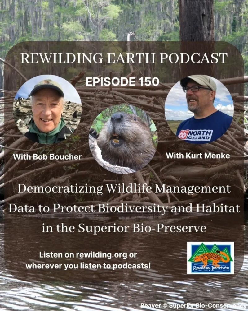
On this episode of the Rewilding Earth Podcast, Bob Boucher & I explain a new paradigm of sustainable beaver management. It involves a connectivity analysis using Omniscape plus the use of Mergin Maps & #QGIS.
This will allow beavers to serve their role as a keystone species and ecosystem engineers
This will allow beavers to serve their role as a keystone species and ecosystem engineers
June 6, 2025 at 6:34 AM
On this episode of the Rewilding Earth Podcast, Bob Boucher & I explain a new paradigm of sustainable beaver management. It involves a connectivity analysis using Omniscape plus the use of Mergin Maps & #QGIS.
This will allow beavers to serve their role as a keystone species and ecosystem engineers
This will allow beavers to serve their role as a keystone species and ecosystem engineers
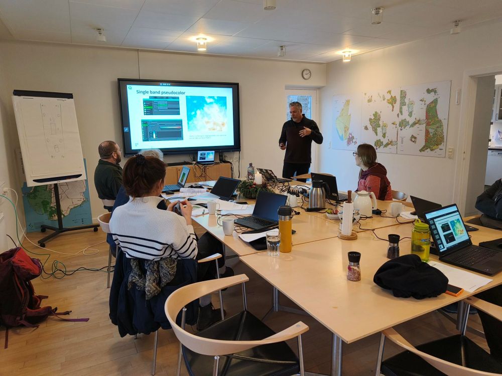
The spring Danish QGIS User Group meeting is underway in Nyborg!

May 7, 2025 at 9:29 AM
The spring Danish QGIS User Group meeting is underway in Nyborg!
I am proud that my company, Septima, just renewed their #QGIS sustaining membership. The Sustaining Membership Program is a vital funding stream for this amazing community-driven open-source project!
If you use QGIS, please consider also becoming a sustaining member: qgis.org/funding/memb...
If you use QGIS, please consider also becoming a sustaining member: qgis.org/funding/memb...

February 18, 2025 at 10:07 AM
I am proud that my company, Septima, just renewed their #QGIS sustaining membership. The Sustaining Membership Program is a vital funding stream for this amazing community-driven open-source project!
If you use QGIS, please consider also becoming a sustaining member: qgis.org/funding/memb...
If you use QGIS, please consider also becoming a sustaining member: qgis.org/funding/memb...
Discover QGIS 3.x is now available at Philipps-Universität Marburg 🇩🇪!
I wrote this to support teaching GIS w/ QGIS. If you plan on teaching #QGIS at your school, consider using it.
It contains 32 lab exercises w/ solution files & challenge assignments to support learning.
locatepress.com/book/dq32
I wrote this to support teaching GIS w/ QGIS. If you plan on teaching #QGIS at your school, consider using it.
It contains 32 lab exercises w/ solution files & challenge assignments to support learning.
locatepress.com/book/dq32

January 22, 2025 at 6:45 PM
Discover QGIS 3.x is now available at Philipps-Universität Marburg 🇩🇪!
I wrote this to support teaching GIS w/ QGIS. If you plan on teaching #QGIS at your school, consider using it.
It contains 32 lab exercises w/ solution files & challenge assignments to support learning.
locatepress.com/book/dq32
I wrote this to support teaching GIS w/ QGIS. If you plan on teaching #QGIS at your school, consider using it.
It contains 32 lab exercises w/ solution files & challenge assignments to support learning.
locatepress.com/book/dq32
RIP David Lynch - one of my favorite directors

January 16, 2025 at 9:23 PM
RIP David Lynch - one of my favorite directors
#30DayMapChallenge 2024 Day 13: A New Tool part 2
I just played with Pretty Maps to make a quick fall themed map of old Tallinn, Estonia
I just played with Pretty Maps to make a quick fall themed map of old Tallinn, Estonia

December 13, 2024 at 12:52 PM
#30DayMapChallenge 2024 Day 13: A New Tool part 2
I just played with Pretty Maps to make a quick fall themed map of old Tallinn, Estonia
I just played with Pretty Maps to make a quick fall themed map of old Tallinn, Estonia
#30DayMapChallenge 2024 Day 11: Arctic
A temporal animation of the circumpolar migration of Arctic Terns. They have the longest migration, seeing 2 summers each year, as they migrate along a route from northern breeding grounds in the Arctic, to the Antarctic coast for the southern summer & back.
A temporal animation of the circumpolar migration of Arctic Terns. They have the longest migration, seeing 2 summers each year, as they migrate along a route from northern breeding grounds in the Arctic, to the Antarctic coast for the southern summer & back.
December 13, 2024 at 12:51 PM
#30DayMapChallenge 2024 Day 11: Arctic
A temporal animation of the circumpolar migration of Arctic Terns. They have the longest migration, seeing 2 summers each year, as they migrate along a route from northern breeding grounds in the Arctic, to the Antarctic coast for the southern summer & back.
A temporal animation of the circumpolar migration of Arctic Terns. They have the longest migration, seeing 2 summers each year, as they migrate along a route from northern breeding grounds in the Arctic, to the Antarctic coast for the southern summer & back.
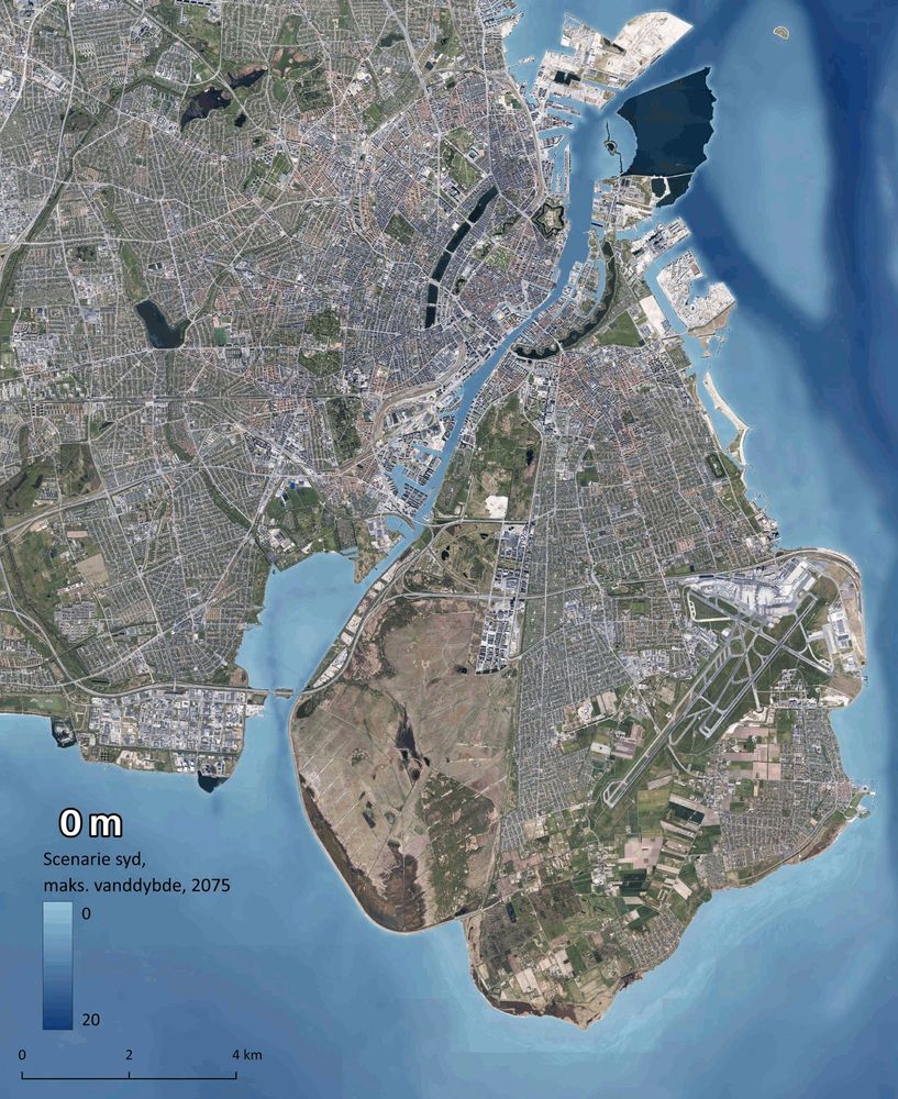
#30DayMapChallenge 2024 Day 12: Time and Space
An animation of storm induced flooding in Copenhagen from a scenario modeling potential conditions from a 1,000 year storm coming from the south in 2075. Made with #QGIS and #ffmpeg
An animation of storm induced flooding in Copenhagen from a scenario modeling potential conditions from a 1,000 year storm coming from the south in 2075. Made with #QGIS and #ffmpeg
December 13, 2024 at 12:47 PM
#30DayMapChallenge 2024 Day 12: Time and Space
An animation of storm induced flooding in Copenhagen from a scenario modeling potential conditions from a 1,000 year storm coming from the south in 2075. Made with #QGIS and #ffmpeg
An animation of storm induced flooding in Copenhagen from a scenario modeling potential conditions from a 1,000 year storm coming from the south in 2075. Made with #QGIS and #ffmpeg
10 years ago! It was such an honor. I had a 15 year relationship with the National Library of Medicine before moving to Denmark. During this time, I developed a program named Community Health Maps (lnkd.in/eAhnHZC6) for public health officials working with under-served and at-risk communities.

December 8, 2024 at 3:14 PM
10 years ago! It was such an honor. I had a 15 year relationship with the National Library of Medicine before moving to Denmark. During this time, I developed a program named Community Health Maps (lnkd.in/eAhnHZC6) for public health officials working with under-served and at-risk communities.
#30DayMapChallenge 2024 Day 7: Vintage style
UFO sightings in Denmark. There have not been many! Data from: www.kaggle.com/datasets/NUF...
#QGIS
UFO sightings in Denmark. There have not been many! Data from: www.kaggle.com/datasets/NUF...
#QGIS

December 7, 2024 at 9:31 AM
#30DayMapChallenge 2024 Day 7: Vintage style
UFO sightings in Denmark. There have not been many! Data from: www.kaggle.com/datasets/NUF...
#QGIS
UFO sightings in Denmark. There have not been many! Data from: www.kaggle.com/datasets/NUF...
#QGIS
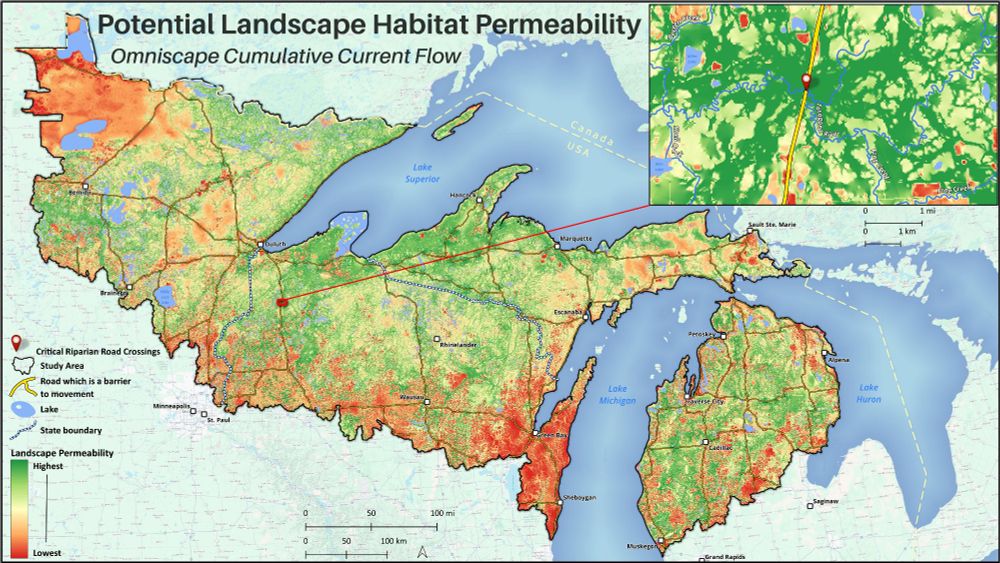
#30DayMapChallenge 2024 Day 6: Raster
This is an analysis for the Superior Bio-Conservancy with the goal of modeling biodiversity connectivity in the North Woods. I used Omniscape.jl to model wall-2-wall structural connectivity across the study area w/ emphasis on riparian corridors & biodiversity
This is an analysis for the Superior Bio-Conservancy with the goal of modeling biodiversity connectivity in the North Woods. I used Omniscape.jl to model wall-2-wall structural connectivity across the study area w/ emphasis on riparian corridors & biodiversity
December 6, 2024 at 7:17 AM
#30DayMapChallenge 2024 Day 6: Raster
This is an analysis for the Superior Bio-Conservancy with the goal of modeling biodiversity connectivity in the North Woods. I used Omniscape.jl to model wall-2-wall structural connectivity across the study area w/ emphasis on riparian corridors & biodiversity
This is an analysis for the Superior Bio-Conservancy with the goal of modeling biodiversity connectivity in the North Woods. I used Omniscape.jl to model wall-2-wall structural connectivity across the study area w/ emphasis on riparian corridors & biodiversity
#30DayMapChallenge 2024 Day 5: A journey
Here is an animation of my 500 mi / 800 km hike across Oregon in 1994. 38 days sleeping in a tent - swam in 36 lakes - climbed 7 peaks - one of the best outdoor adventures I've had! Made via the QGIS Atlas.
#QGIS #PCT #Oregon
Here is an animation of my 500 mi / 800 km hike across Oregon in 1994. 38 days sleeping in a tent - swam in 36 lakes - climbed 7 peaks - one of the best outdoor adventures I've had! Made via the QGIS Atlas.
#QGIS #PCT #Oregon

December 5, 2024 at 9:34 AM
#30DayMapChallenge 2024 Day 5: A journey
Here is an animation of my 500 mi / 800 km hike across Oregon in 1994. 38 days sleeping in a tent - swam in 36 lakes - climbed 7 peaks - one of the best outdoor adventures I've had! Made via the QGIS Atlas.
#QGIS #PCT #Oregon
Here is an animation of my 500 mi / 800 km hike across Oregon in 1994. 38 days sleeping in a tent - swam in 36 lakes - climbed 7 peaks - one of the best outdoor adventures I've had! Made via the QGIS Atlas.
#QGIS #PCT #Oregon
#30DayMapChallenge 2024 Day 4: Hexagons
Archaeological site density in Denmark by hexagon within a hexagon 😉 .
#QGIS #archaeology #hexagon
Archaeological site density in Denmark by hexagon within a hexagon 😉 .
#QGIS #archaeology #hexagon

December 4, 2024 at 9:12 AM
#30DayMapChallenge 2024 Day 4: Hexagons
Archaeological site density in Denmark by hexagon within a hexagon 😉 .
#QGIS #archaeology #hexagon
Archaeological site density in Denmark by hexagon within a hexagon 😉 .
#QGIS #archaeology #hexagon
#30DayMapChallenge 2024 Day 3: Polygons
Mean elevation in Denmark by municipality.
#QGIS #Denmark #Elevation
Mean elevation in Denmark by municipality.
#QGIS #Denmark #Elevation

December 3, 2024 at 7:21 AM
#30DayMapChallenge 2024 Day 3: Polygons
Mean elevation in Denmark by municipality.
#QGIS #Denmark #Elevation
Mean elevation in Denmark by municipality.
#QGIS #Denmark #Elevation
#30DayMapChallenge 2024 Day 2: Lines
One of the best parts of our #PCT hike was the 3 Sisters. We loaded up our fanny packs to climb South Sister. On the way back down, we wanted to head straigh to camp, so we went down the NW side and unintentionally glissaded about 800 m down the Lost Ck Glacier.
One of the best parts of our #PCT hike was the 3 Sisters. We loaded up our fanny packs to climb South Sister. On the way back down, we wanted to head straigh to camp, so we went down the NW side and unintentionally glissaded about 800 m down the Lost Ck Glacier.

December 2, 2024 at 8:41 AM
#30DayMapChallenge 2024 Day 2: Lines
One of the best parts of our #PCT hike was the 3 Sisters. We loaded up our fanny packs to climb South Sister. On the way back down, we wanted to head straigh to camp, so we went down the NW side and unintentionally glissaded about 800 m down the Lost Ck Glacier.
One of the best parts of our #PCT hike was the 3 Sisters. We loaded up our fanny packs to climb South Sister. On the way back down, we wanted to head straigh to camp, so we went down the NW side and unintentionally glissaded about 800 m down the Lost Ck Glacier.
#30DayMapChallenge 2024 Day 1: Points
I am celebrating the 30 year anniversary of my hike across Oregon on the Pacific Crest Trail, with a map of the route styled with only points. It was fun playing with the point pattern fill and marker lines renderers.
#QGIS #PCT #Oregon

December 2, 2024 at 8:18 AM
#30DayMapChallenge 2024 Day 1: Points
I am celebrating the 30 year anniversary of my hike across Oregon on the Pacific Crest Trail, with a map of the route styled with only points. It was fun playing with the point pattern fill and marker lines renderers.
#QGIS #PCT #Oregon
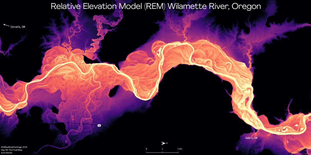
#30DayMapChallenge 2024 Day 30: The Final Map
I've spent a lot of time playing with Relative Elevation Models (REM's) recently. This is my favorite - The Wilamette River between Corvallis and Salem Oregon. I used the IDW method detailed by Dan Coe Carto here: dancoecarto.com/creating-rem...
#QGIS
I've spent a lot of time playing with Relative Elevation Models (REM's) recently. This is my favorite - The Wilamette River between Corvallis and Salem Oregon. I used the IDW method detailed by Dan Coe Carto here: dancoecarto.com/creating-rem...
#QGIS
November 30, 2024 at 7:57 AM
#30DayMapChallenge 2024 Day 30: The Final Map
I've spent a lot of time playing with Relative Elevation Models (REM's) recently. This is my favorite - The Wilamette River between Corvallis and Salem Oregon. I used the IDW method detailed by Dan Coe Carto here: dancoecarto.com/creating-rem...
#QGIS
I've spent a lot of time playing with Relative Elevation Models (REM's) recently. This is my favorite - The Wilamette River between Corvallis and Salem Oregon. I used the IDW method detailed by Dan Coe Carto here: dancoecarto.com/creating-rem...
#QGIS
#30DayMapChallenge 2024 Day 28: The Blue Planet
A quick rendering of the Pacific Ocean, aka Oceania, one of my favorite places. Although to be fair, I have only visited Hawaii, Samoa and Micronesia.
Using #QGIS, I simply styled the included MapZen Global Terrain and used the Globe Builder plugin.
A quick rendering of the Pacific Ocean, aka Oceania, one of my favorite places. Although to be fair, I have only visited Hawaii, Samoa and Micronesia.
Using #QGIS, I simply styled the included MapZen Global Terrain and used the Globe Builder plugin.

November 28, 2024 at 10:35 AM
#30DayMapChallenge 2024 Day 28: The Blue Planet
A quick rendering of the Pacific Ocean, aka Oceania, one of my favorite places. Although to be fair, I have only visited Hawaii, Samoa and Micronesia.
Using #QGIS, I simply styled the included MapZen Global Terrain and used the Globe Builder plugin.
A quick rendering of the Pacific Ocean, aka Oceania, one of my favorite places. Although to be fair, I have only visited Hawaii, Samoa and Micronesia.
Using #QGIS, I simply styled the included MapZen Global Terrain and used the Globe Builder plugin.

November 27, 2024 at 10:17 AM
#30DayMapChallenge 2024 Day 26: Map projections
A North pole map featuring a polar Lambert Equal Area projection centered on Europe. #QGIS
A North pole map featuring a polar Lambert Equal Area projection centered on Europe. #QGIS

November 26, 2024 at 8:15 AM
#30DayMapChallenge 2024 Day 26: Map projections
A North pole map featuring a polar Lambert Equal Area projection centered on Europe. #QGIS
A North pole map featuring a polar Lambert Equal Area projection centered on Europe. #QGIS
#30DayMapChallenge 2024 Day 25: Heat
Mean maximum temperature on a monthly basis from 1970-2020. Animated in QGIS. Data source: WorldClim 21.
Mean maximum temperature on a monthly basis from 1970-2020. Animated in QGIS. Data source: WorldClim 21.
November 25, 2024 at 12:51 PM
#30DayMapChallenge 2024 Day 25: Heat
Mean maximum temperature on a monthly basis from 1970-2020. Animated in QGIS. Data source: WorldClim 21.
Mean maximum temperature on a monthly basis from 1970-2020. Animated in QGIS. Data source: WorldClim 21.
Here is a bonus animation as the hike was recorded with my GPS watch
November 24, 2024 at 9:05 AM
Here is a bonus animation as the hike was recorded with my GPS watch
#30DayMapChallenge 2024 Day 24: Only Circular Shapes
Denmarks Population by Age Group per Municipality. The charts are sized by the area of each municipality.
#QGIS
Denmarks Population by Age Group per Municipality. The charts are sized by the area of each municipality.
#QGIS

November 24, 2024 at 8:38 AM
#30DayMapChallenge 2024 Day 24: Only Circular Shapes
Denmarks Population by Age Group per Municipality. The charts are sized by the area of each municipality.
#QGIS
Denmarks Population by Age Group per Municipality. The charts are sized by the area of each municipality.
#QGIS
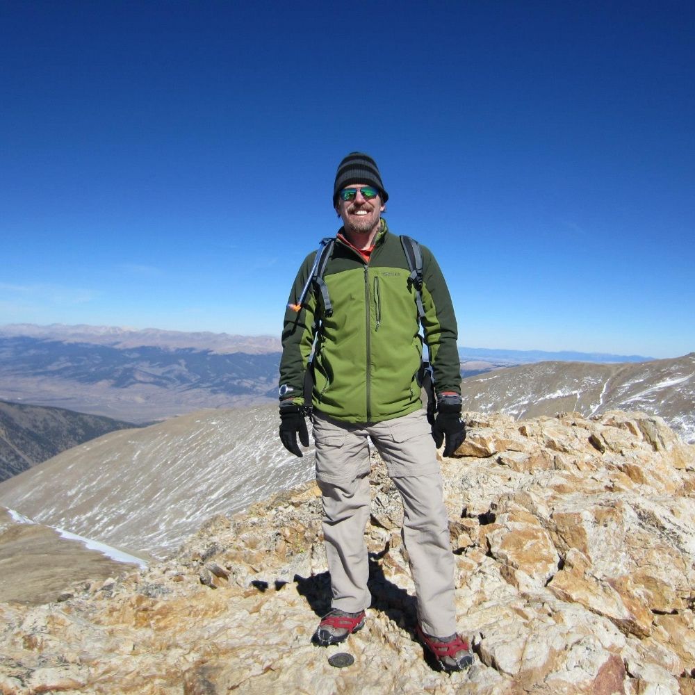
#30DayMapChallenge 2024 Day 23: Memory
12 years ago today, I climbed Mt. Shavano (14,229 ft - 4,337 m). In a typical year, this mountain can be covered in snow by late November, but 12 years ago, it was unseasonably warm. The hike was recorded with my Suunto Ambit GPS watch.
#QGIS #Suunto
12 years ago today, I climbed Mt. Shavano (14,229 ft - 4,337 m). In a typical year, this mountain can be covered in snow by late November, but 12 years ago, it was unseasonably warm. The hike was recorded with my Suunto Ambit GPS watch.
#QGIS #Suunto

November 24, 2024 at 8:32 AM
#30DayMapChallenge 2024 Day 23: Memory
12 years ago today, I climbed Mt. Shavano (14,229 ft - 4,337 m). In a typical year, this mountain can be covered in snow by late November, but 12 years ago, it was unseasonably warm. The hike was recorded with my Suunto Ambit GPS watch.
#QGIS #Suunto
12 years ago today, I climbed Mt. Shavano (14,229 ft - 4,337 m). In a typical year, this mountain can be covered in snow by late November, but 12 years ago, it was unseasonably warm. The hike was recorded with my Suunto Ambit GPS watch.
#QGIS #Suunto