Isle of Man Public Record Office
@isleofmanpro.bsky.social
130 followers 130 following 30 posts
The National Record Office of the Isle of Man, preserving the historic archives of Isle of Man Government and public bodies.
Posts Media Videos Starter Packs
Pinned
isleofmanpro.bsky.social
NOTICE: Our reading room will be closed Friday 3rd and Friday 10th October for our Heritage Open Days events: tinyurl.com/4szbxvm3. We'll still be responding to calls and emails on these days, and Thursdays are unaffected. Best wishes from the PRO Team. #HOD2025 #Archives
isleofmanpro.bsky.social
In honour of #WorldOctopusDay, our mascot Orry is perusing historical Isle of Man Fisheries minutes to discover what local marine life was like in the past. #ManxArchives #ExploreYourArchives #IrishSea #ManxWildlife #Cephalopods
Colour photograph showing small orange plushie octopus viewing a volume of handwritten minutes. The volume is open on a bookrest and the octopus is seated on the table in front of it. He is making notes in pencil with one of his left arms.
isleofmanpro.bsky.social
NOTICE: Our reading room will be closed Friday 3rd and Friday 10th October for our Heritage Open Days events: tinyurl.com/4szbxvm3. We'll still be responding to calls and emails on these days, and Thursdays are unaffected. Best wishes from the PRO Team. #HOD2025 #Archives
isleofmanpro.bsky.social
It's our favourite time of year! Yes, Heritage Open Days are here again, and we're offering free guided tours of our archives. Book a place to begin your journey of discovery! #ManxArchives #ManxHeritage #ExploreYourArchive tinyurl.com/2vw3un45#Exp...
Public Record Office – Explore Your National Archives: Guided Tour
tinyurl.com
isleofmanpro.bsky.social
As it's #ManxGrandPrix race week, this week's #TithePlanTuesday comes to you from a notorious section of the TT course! In 1835, Ballagarey Farm was owned by a Scottish lawyer, Norman Lockhart. This plan shows the usage of each field - crops, clover, pasture, and meadow. #ManxArchives #IsleOfMan
Colour photograph of a Tithe Plan of Ballagarey Farm dating from 1835. The plan shows the full extent of the land owned by N. Lockhart Esq, with the dimensions of each plot given in acres, roods and perches. The farmhouse itself is shown; it is close to the main road between Peel and Douglas. Colour photograph of detail of the same Tithe Plan, focusing on the farm buildings close to the road. The owner's lands extend from both sides of the road.
isleofmanpro.bsky.social
#DidYouKnow there was an effort to revive the Isle of Man's mining industry in the mid-20th Century? Under Government licence, The Island Exploration Company carried out mapping, surveying, drilling and prospecting work until 1968. Find out more: tinyurl.com/37k7defv #Archives
Colour image of the cover of a file relating to diamond drilling. Diamond drilling was carried out 1956-1957 at various sites, including Cornelly, Slieau Whallian and Ballacorkish. Colour image of a number of files relating to electromagnetic surveys carried out in the 1950s at sites including Sartfell, Granite Mountain and Old Flappy. Colour image of a typewritten document titled 'Memorandum on the Present State of the Exploration for Mineral Deposits in the Isle of Man'. The document originates from The Island Exploration Company Ltd and dates from August 1957. The introduction lists the 'producing mines' of the 19th Century, drawing on two primary sources. Colour image of index page relating to field samples collected 1956-1957. Locations include Windy Common, Carnagray and Glen Rushen.
isleofmanpro.bsky.social
Maps and plans help us to visualise places when physical traces no longer remain. This Asylum Plan shows us Cooper's Mill in Peel in 1864. The buildings shown here date from 1859, when the mill was rebuilt after a fire. #TithePlanTuesday #IndustrialArchaeology #ManxArchives
Colour photograph of a hand-drawn plan titled 'Plan and Survey of Coopers Mill and premises at the top of Peel Harbour in the parish of Patrick belonging to the poor'. The mill site is shown as being on the right side of the River Neb with the mill dam immediately south of it. There is a ford across the river opposite the dam. A note at the foot of the plan says that this land was surveyed January 9th 1864 by William Kaighin. Section of 1868 Ordnance Survey map (IX.6) showing Cooper's Mill. Here it is named 'Flour Mill' but contemporary sources describe it as a 'water corn mill'. The Rope Works are shown south of the mill dam.
isleofmanpro.bsky.social
A new catalogue has landed! Created by our colleague Robyn, 'Records of the UK Board of Trade: Marine Maps and Plans of the Isle of Man 1858-1982' comprises 267 records relating to works around the Island's coastline. Explore the catalogue: tinyurl.com/nnx5m224 #ManxArchives #SeasideArchitecture
Image shows colour plan created in 1869 depicting a proposed leading light for the Iron Pier in Douglas. The plan is signed by John Dixon, Engineer and Contractor, and dated 16th July 1869. The plan shows the intended position of the light at the end of the pier, close to an ornate refreshments/waiting room.
isleofmanpro.bsky.social
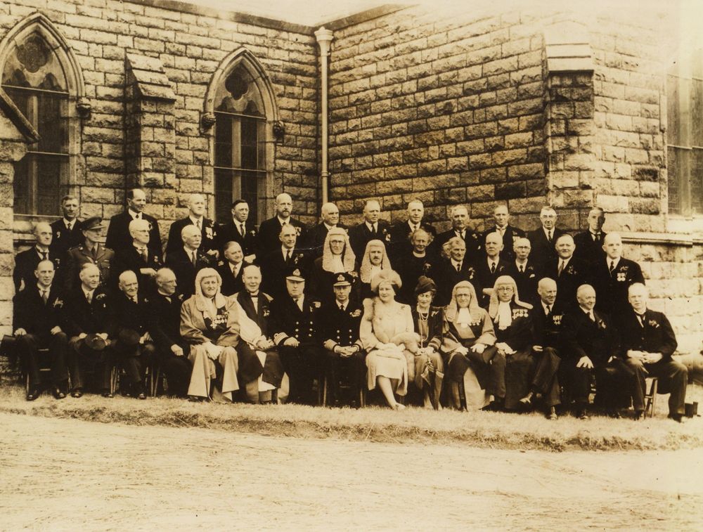
#OnThisDay in 1907, the opening of Ramsey Cottage Hospital took place in, the Ramsey Courier noted, "delightful weather, in the presence of a numerous... and influential assemblage". Our collection of RCH records includes the earliest House Committee minutes. #ManxArchives #IsleOfMan
Black and white photograph showing a distinguished gathering in front of Ramsey Cottage Hospital. Colour photograph showing the first entry in the first minute book of Ramsey Cottage Hospital's House Committee, dated 31st December 1907.
isleofmanpro.bsky.social
While the #IsleOfMan is experiencing a moderate version of the current heatwave, we're still looking longingly at this 1957 photograph of the fountain on Loch Promenade. Wishing everyone a fantastic weekend in the sun or shade! #ManxArchives #SummerVibes #SeasideArchitecture
Black and white photograph showing the fountain in the 'sunken gardens' on Loch Promenade in Douglas, Isle of Man. There are people in summer clothes sitting on the wall around the fountain. In the background, lots of people can be seen walking along the promenade or leaning against the sea wall.
isleofmanpro.bsky.social
Happy Tynwald Day, everyone! This photograph from our collections shows King George VI and Queen Elizabeth on Tynwald Day in 1945. This was the first time that a reigning British sovereign had presided over the ancient ceremony. #IsleOfMan #ManxArchives #LaaTinvaal 🇮🇲
isleofmanpro.bsky.social
This week's #TithePlanTuesday comes to you from the parish of Michael. Isn't this 1839 plan of Ballacarnane Moar wonderful? Surveyor Patrick Kelly typically embellished his work in this fashion when the land-holding was sizeable and the landowner of some standing. #ManxArchives #IsleOfMan
Photograph of a large and colourful tithe plan unfolded and displayed in full (the plan is bound in a volume). The plan is of lands collectively titled Balla-Carnane Moor, the property of Mr J. Cannell. Thet surveyor has added decorative touches in yellow and green, including foliage, two peacocks, and two male heads, one wearing a crown and the other, some manner of feathered ceremonial headdress. Photograph of plan detail showing a pair of yellow and green peacocks perching above a kind of dais, mirroring each other, surrounded by foliage. The peacocks each hold a leaf in their beak. Photograph of plan detail showing the heads of two bearded gentlemen who are wearing large and fantastical headgear. Above them is a tree with delicate foliage, sprouting from a heart-shaped base. The surnames Thompson and Christian have been written next to the faces; these names do not correspond to any landowners' names on the plan.
isleofmanpro.bsky.social
NOTICE: The PRO will be closed Friday 6th June due to the #IOMTT bank holiday. Our reading room will be open as usual on Thursday and Friday the following week. archives.gov.im #ManxArchives
isleofmanpro.bsky.social
The Douglas War Memorial was unveiled #OnThisDay in 1924. It was funded by public subscription, designed by Ewart Crellin, and constructed by Thomas Quayle. This photograph, a tourism competition entry, dates from 1958. #ManxArchives #IsleOfMan #MilitaryHistory
Black and white photograph showing (on the left) the Douglas War Memorial situated on the seaward side of Harris Promenade and (on the right) a horse tram proceeding in a northerly direction. Douglas Head is visible in the background.
isleofmanpro.bsky.social
For this week's #TithePlanTuesday, we're in St Mark's in Malew parish. The village fair is still held on the site below the church cottages. In May 1880, a reporter at the fair commented that "rival manure merchants and the sellers of 'jough' (ale)" saw the liveliest trade. #ManxArchives #IsleOfMan
Colour photograph of a small plan dated 21st January 1864 and drawn by Philip Mylrea. The plan gives an overview of three cottages - the property of the Trustees of St Mark's - which are adjacent to St Mark's Churchyard. The site of St Mark's Fairground is shown as immediately south of the cottages. Colour photograph of a plan and survey of the Glebe of St Mark's. The plan is described as having been drawn by William Cowley in 1841 (or possibly 1847) with alterations by Philip Mylrea in 1862. Land-holdings are coloured green; roads and tracks are in yellow. The measurements of each land-holding are given in acres, roods and perches. The village church and schoolhouse are shown.
isleofmanpro.bsky.social
On 10th May 1897, the Snaefell Mine Disaster - the worst such event in the Isle of Man's history - claimed the lives of twenty men. In the wake of the tragedy, a disaster fund was established to provide relief for the victims' widows, children & parents; this volume lists their names. #ManxArchives
The image shows a typed communication dated 18th May 1897 from Herbert Story, Treasurer of the Isle of Man. It relates to the creation of a committee, following resolutions passed by Tynwald, whose aim was to raise funds "for the relief of those who have suffered in consequence of this lamentable disaster, by which twenty persons have lost their lives, and many others have been rendered widows or fatherless". The image shows two pages in the volume of Snaefell Disaster Fund Committee minutes [ref: A368]. The first page is headed 'List of Sufferers by the Disaster'. The names and ages of the victims' widows and children are listed. Also listed are those victims who were members of Benefit Societies (e.g. Rechabite, Oddfellow).
isleofmanpro.bsky.social
The Isle of Man Railway Company laid on special trains for such occasions as school and church outings. During World War Two, these volumes also record trains deployed for the movement of 'alien' internees, as shown in this notice from 5th May 1942. #OnThisDay #ManxArchives
Colour photo of the front cover of the Special Train Notices 1940 volume. The cover is green, the binding is brown, and the title has been handwritten. Colour photograph of a typed notice bound into the Special Train Notices 1942 volume. It concerns the escorted movement of internees by train from Ramsey to Port Erin via Douglas. On the return journey, the party travelled from Port Erin to St John's by bus, then by train from St John's to Ramsey.
isleofmanpro.bsky.social
We're lucky to have an abundance of beautiful plans like this in our archives! Their artistry holds up a mirror to the time in which they were created.
isleofmanpro.bsky.social
Spanning over a century, #IsleOfMan planning records constitute our most widely-used #ArchiveCollection. Casting light on the history of properties and the people connected to them, these records also work in tandem with other collections in our archive to aid research. #Archive30 #ManxArchives
Colour plan from 1925 showing a proposed four-bedroom house near Peel for Miss Morrison. Floor plans and elevations are shown. Hand-drawn plan from 1888 showing the front elevation of the Walpole Hotel, which stood on Walpole Avenue in Douglas.
isleofmanpro.bsky.social
For #ArchiveObject, here's a piece of #IsleOfMan education history: an ornamental stonemason's mallet presented to Lady Elizabeth Loch on laying the foundation stone of Philip Christian's Boys' School on Poortown Road, Peel, in 1877. #Archive30 #ExploreYourArchive #ManxArchives
Colour photograph of an ornamental stonemason's mallet in its presentation case. The mallet is made from ivory with silver plaques and decorative trimmings. Colour photograph showing in close-up an inscribed silver boss fixed to the head of the mallet. The text reads: Presented to Mrs Loch on laying the foundation stone of Philip Christian's School, Peel, 15th June 1877'.
isleofmanpro.bsky.social
Town plans are always popular with enquirers and tour groups. We all like to see how a familiar place looked a century or two ago, and a single record yields so much information! This plan shows Ramsey in 1848. #PopularItem #Archive30 #ExploreYourArchive #ManxArchives
Colour photograph showing the entirety of the 1848 Ramsey town plan. The Sulby River, harbour area and shore are shown. Also shown are town landmarks, businesses, streets, wells, property owners, and tenants. Colour photograph of a portion of the 1848 Ramsey town plan showing the harbour area. St Paul's Church and the Courthouse can be seen. Other landmarks include chapels, a post office, a timber yard, a smithy, and several public houses. Colour photograph of a portion of the 1848 Ramsey town plan showing Albion Terrace, Crowe's Stream, and part of Lezayre Street. Colour photograph of a portion of the 1848 Ramsey town plan covering a stretch of 'Sandy Road' (now Bowring Road) and the start of Jurby Road, where the windmill of Lezayre Mill is shown.
isleofmanpro.bsky.social
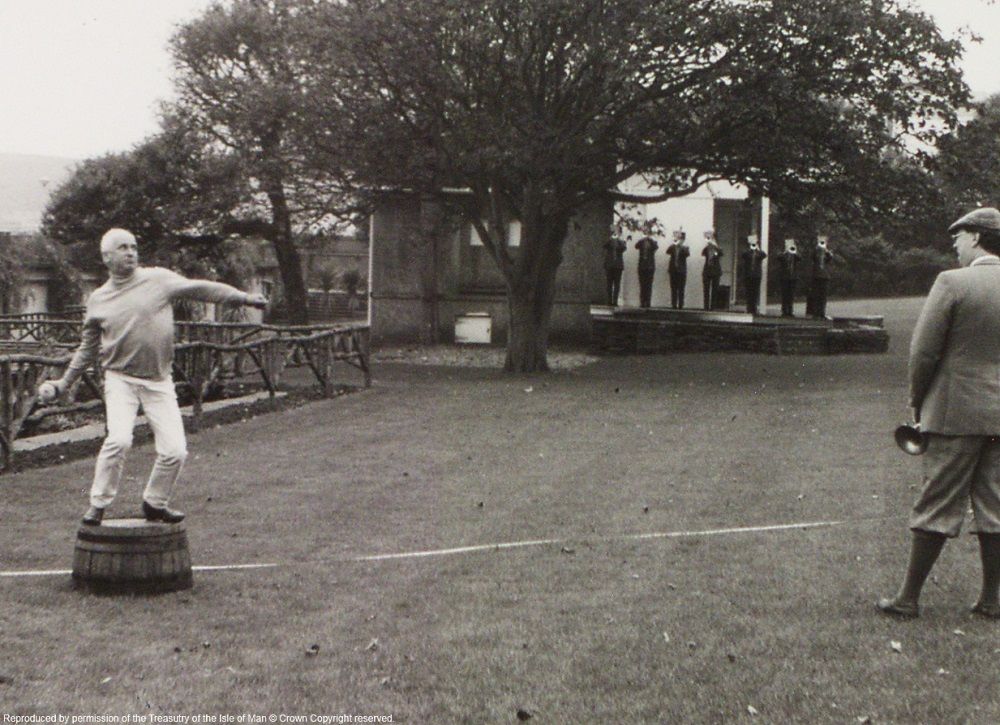
Of all the great sportspeople the Isle of Man has produced through the years, many have gone unsung due to the low profile of their discipline. We'd like to remedy this by saluting these champions of pram-racing and haggis-hurling. #FunAndGames #Archive30 #ManxArchives
Black and white photograph of pram-racing competitors in Onchan Stadium in 1955. A man on a motorbike is towing another man in a pram. He is looking back at his team-mate, who has fallen out of the pram and onto the field. Black and white photograph (dating circa 1980s) of a haggis-hurling contestant in Villa Marina Gardens. He is standing on a whisky barrel and is poised to hurl the haggis. There is a tape measure laid out on the ground behind him. A man in plus fours and a cap looks on. In the background, under a tree, there is a line of trumpeters.
isleofmanpro.bsky.social
These wonderful photos from Isle of Man Harbour Commissioners, dating 1930s-1960s, show typical scenes in Douglas as holidaymakers arrive in their thousands. Happy Easter Holidays to everyone from the PRO Team! #ArchiveTravel #Archive30 #ExploreYourArchive #ManxArchives
isleofmanpro.bsky.social
It's #TithePlanTuesday, which this week comes to you from Ballaugh Curraghs. Depicted are privately-owned turbaries: pieces of land where peat or turf could be dug for fuel. The first plan dates from 1826, making it one of the oldest records of its type in our archive. #ManxArchives #IsleOfMan
Photograph of a Tithe Plan titled 'A Plan and Survey of the Lord-Bishop's Courrough in the Parish of Ballaugh'. The plan shows a single area of turbary and meadow land, with its shape, dimensions, and the names of bordering landowners. Photograph of a Tithe Plan showing a turbary belonging to Mr Thomas Nelson. The land-holding is divided into six parts labelled 'a' to 'g', with an overall measurement of four acres, one rood and 31 perches. The names of the neighbouring landowners are shown. The plan dates from 1833.
isleofmanpro.bsky.social
With the #ManxRally2025 underway, we're sharing some photographs from our archives which capture rally action from the 1980s. #ManxArchives #ExploreYourArchive