


James Aydelott
@jamesaydelott.bsky.social
He/Him/His
-😍Daddy to 2
-4th Gen Okie
-BS OU Meteorology -MS OkState Emergency Mngmnt
-PhD student OkState Emergency Mngmnt
-Pilot
-Raconteur
-Antagonist
‘Gram: @jamesaydelottwx
Threads: @jamesaydelottwx
-😍Daddy to 2
-4th Gen Okie
-BS OU Meteorology -MS OkState Emergency Mngmnt
-PhD student OkState Emergency Mngmnt
-Pilot
-Raconteur
-Antagonist
‘Gram: @jamesaydelottwx
Threads: @jamesaydelottwx
442pm—Radar update
Areas of light snow and flurries moving across parts of SE KS and NE OK.
No issues in Tulsa Metro. Up to 1/2” along and near the KS/OK border. #snOMG #snOklahoma
Areas of light snow and flurries moving across parts of SE KS and NE OK.
No issues in Tulsa Metro. Up to 1/2” along and near the KS/OK border. #snOMG #snOklahoma
December 1, 2025 at 10:42 PM
442pm—Radar update
Areas of light snow and flurries moving across parts of SE KS and NE OK.
No issues in Tulsa Metro. Up to 1/2” along and near the KS/OK border. #snOMG #snOklahoma
Areas of light snow and flurries moving across parts of SE KS and NE OK.
No issues in Tulsa Metro. Up to 1/2” along and near the KS/OK border. #snOMG #snOklahoma
242pm—Radar update
Areas of light snow have developed NW of Tulsa.
Might see a slick spot or two on untreated bridges.
#snOMG #snOklahoma #okwx
Areas of light snow have developed NW of Tulsa.
Might see a slick spot or two on untreated bridges.
#snOMG #snOklahoma #okwx
December 1, 2025 at 8:43 PM
242pm—Radar update
Areas of light snow have developed NW of Tulsa.
Might see a slick spot or two on untreated bridges.
#snOMG #snOklahoma #okwx
Areas of light snow have developed NW of Tulsa.
Might see a slick spot or two on untreated bridges.
#snOMG #snOklahoma #okwx
743am—Radar update
Light wintry mix continues to push east. We will still see chances of light sleet, rain or snowflakes into the afternoon, but road conditions will slowly improve through 10am. #okwx
Light wintry mix continues to push east. We will still see chances of light sleet, rain or snowflakes into the afternoon, but road conditions will slowly improve through 10am. #okwx
December 1, 2025 at 1:46 PM
743am—Radar update
Light wintry mix continues to push east. We will still see chances of light sleet, rain or snowflakes into the afternoon, but road conditions will slowly improve through 10am. #okwx
Light wintry mix continues to push east. We will still see chances of light sleet, rain or snowflakes into the afternoon, but road conditions will slowly improve through 10am. #okwx
656am— Memorial Drive/US-64 bridge over the Arkansas River is closed because of accidents

December 1, 2025 at 12:57 PM
656am— Memorial Drive/US-64 bridge over the Arkansas River is closed because of accidents
Tulsa drivers:
Crashes on BA Expy westbound at 169 and on 169 northbound at 51st. Delays building.
Crashes on BA Expy westbound at 169 and on 169 northbound at 51st. Delays building.

December 1, 2025 at 12:54 PM
Tulsa drivers:
Crashes on BA Expy westbound at 169 and on 169 northbound at 51st. Delays building.
Crashes on BA Expy westbound at 169 and on 169 northbound at 51st. Delays building.
629am—Radar update
wintry mix of light sleet and freezing rain continues across Eastern Oklahoma. Be alert for icy spots, especially untreated bridges and overpasses. #okwx
wintry mix of light sleet and freezing rain continues across Eastern Oklahoma. Be alert for icy spots, especially untreated bridges and overpasses. #okwx
December 1, 2025 at 12:31 PM
629am—Radar update
wintry mix of light sleet and freezing rain continues across Eastern Oklahoma. Be alert for icy spots, especially untreated bridges and overpasses. #okwx
wintry mix of light sleet and freezing rain continues across Eastern Oklahoma. Be alert for icy spots, especially untreated bridges and overpasses. #okwx
Well, well, well.
Turkey radar unavailable??
Trying to make an escape before a Thanksgiving, I see. 🦃
Turkey radar unavailable??
Trying to make an escape before a Thanksgiving, I see. 🦃

November 25, 2025 at 3:44 AM
Well, well, well.
Turkey radar unavailable??
Trying to make an escape before a Thanksgiving, I see. 🦃
Turkey radar unavailable??
Trying to make an escape before a Thanksgiving, I see. 🦃
November 20, 2025 at 5:27 AM
1045pm-Radar update
Severe Storm in SE Washington County, moving NE toward Nowata. Slow weakening trend noted, but still capable of quarter sized hail. No rotation. #okwx
Severe Storm in SE Washington County, moving NE toward Nowata. Slow weakening trend noted, but still capable of quarter sized hail. No rotation. #okwx
November 20, 2025 at 4:46 AM
1045pm-Radar update
Severe Storm in SE Washington County, moving NE toward Nowata. Slow weakening trend noted, but still capable of quarter sized hail. No rotation. #okwx
Severe Storm in SE Washington County, moving NE toward Nowata. Slow weakening trend noted, but still capable of quarter sized hail. No rotation. #okwx
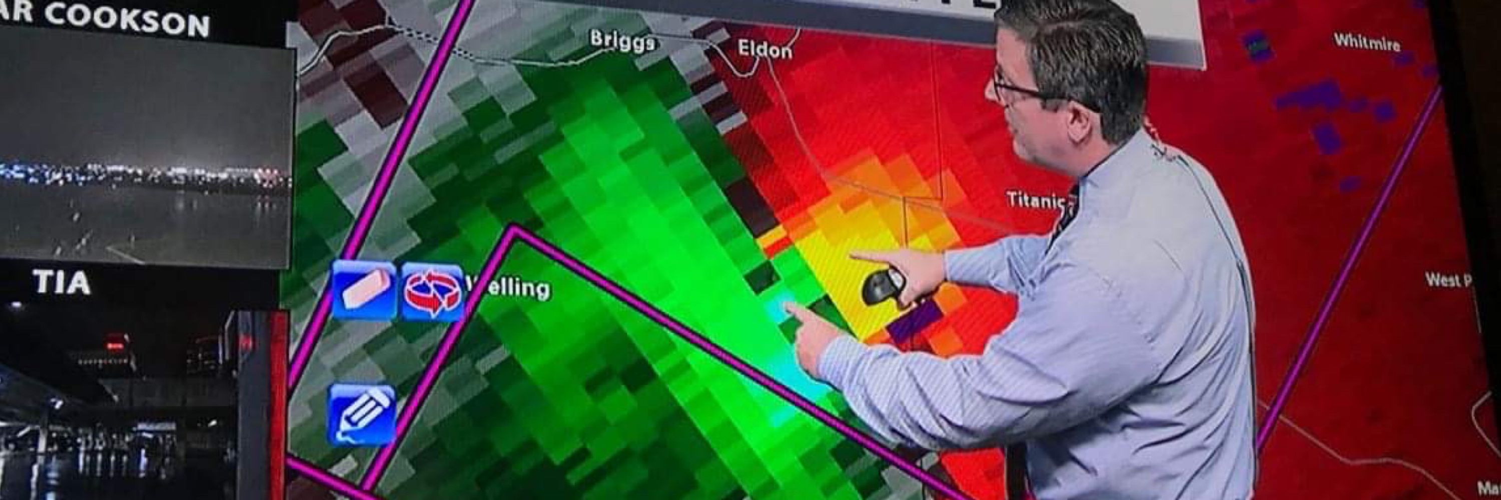
936pm-Radar update
Severe storm moving over Mannford now. Hail up to half-dollar size possible. Post pics of the hail in replies if you can. #okwx
Severe storm moving over Mannford now. Hail up to half-dollar size possible. Post pics of the hail in replies if you can. #okwx
November 20, 2025 at 3:38 AM
936pm-Radar update
Severe storm moving over Mannford now. Hail up to half-dollar size possible. Post pics of the hail in replies if you can. #okwx
Severe storm moving over Mannford now. Hail up to half-dollar size possible. Post pics of the hail in replies if you can. #okwx
Skipperdog noticed the sweaty patio.
Not rain, this happens when winds bring humid air in over cold ground/pavement.
The dewpoint is higher than the ground temp, and that moisture condenses on cooler surfaces.
Usually happens in spring and fall when a humid south wind develops quickly. #okwx
Not rain, this happens when winds bring humid air in over cold ground/pavement.
The dewpoint is higher than the ground temp, and that moisture condenses on cooler surfaces.
Usually happens in spring and fall when a humid south wind develops quickly. #okwx

November 14, 2025 at 5:51 PM
Skipperdog noticed the sweaty patio.
Not rain, this happens when winds bring humid air in over cold ground/pavement.
The dewpoint is higher than the ground temp, and that moisture condenses on cooler surfaces.
Usually happens in spring and fall when a humid south wind develops quickly. #okwx
Not rain, this happens when winds bring humid air in over cold ground/pavement.
The dewpoint is higher than the ground temp, and that moisture condenses on cooler surfaces.
Usually happens in spring and fall when a humid south wind develops quickly. #okwx
Seems about right....

November 13, 2025 at 3:46 AM
Seems about right....
Tulsa/BA drivers:
Crash on the BA Expy at 145th E Ave, Eastbound.
Backup about five miles to 41st Street.
Crash on the BA Expy at 145th E Ave, Eastbound.
Backup about five miles to 41st Street.

November 12, 2025 at 11:44 PM
Tulsa/BA drivers:
Crash on the BA Expy at 145th E Ave, Eastbound.
Backup about five miles to 41st Street.
Crash on the BA Expy at 145th E Ave, Eastbound.
Backup about five miles to 41st Street.
Meanwhile, in SE Wisconsin, the joy of Lake Effect Snow forecasting this week.
High-Resolution satellite shows just how short the distance is from heavy snow to zero! #snOMG
High-Resolution satellite shows just how short the distance is from heavy snow to zero! #snOMG

November 12, 2025 at 8:59 PM
Meanwhile, in SE Wisconsin, the joy of Lake Effect Snow forecasting this week.
High-Resolution satellite shows just how short the distance is from heavy snow to zero! #snOMG
High-Resolution satellite shows just how short the distance is from heavy snow to zero! #snOMG
Currently. Speed 0.
BA Expy eastbound to 169 southbound.
BA Expy eastbound to 169 southbound.


November 12, 2025 at 12:39 AM
Currently. Speed 0.
BA Expy eastbound to 169 southbound.
BA Expy eastbound to 169 southbound.
Tulsa drivers:
Another wreck on the BA Expressway, at I-44, westbound direction.
Tulsa's most poorly designed interchange. Bad idea to have entering traffic, exiting traffic, and a lane ending, all in 1/4 mile. Bad, Bad design that needs to be addressed.
Another wreck on the BA Expressway, at I-44, westbound direction.
Tulsa's most poorly designed interchange. Bad idea to have entering traffic, exiting traffic, and a lane ending, all in 1/4 mile. Bad, Bad design that needs to be addressed.

November 10, 2025 at 11:30 PM
Tulsa drivers:
Another wreck on the BA Expressway, at I-44, westbound direction.
Tulsa's most poorly designed interchange. Bad idea to have entering traffic, exiting traffic, and a lane ending, all in 1/4 mile. Bad, Bad design that needs to be addressed.
Another wreck on the BA Expressway, at I-44, westbound direction.
Tulsa's most poorly designed interchange. Bad idea to have entering traffic, exiting traffic, and a lane ending, all in 1/4 mile. Bad, Bad design that needs to be addressed.
hahahahahahahaha
🐀🌶️
🐀🌶️

November 8, 2025 at 12:31 AM
hahahahahahahaha
🐀🌶️
🐀🌶️
This sunset!! Another incredible one! #okwx #TulsaTime

November 8, 2025 at 12:26 AM
This sunset!! Another incredible one! #okwx #TulsaTime
