


Jim Sullivan
@jimsullivan.bsky.social
Meteorologist at NWS Cleveland. I forecast the weather with mixed results. Thoughts and views are my own. Fork off.
While I'd usually advise against posting 360 hour model images, it's always fun when the ensemble mean has closed 500mb height contours north of the Arctic Circle that far out.

November 13, 2025 at 2:17 AM
While I'd usually advise against posting 360 hour model images, it's always fun when the ensemble mean has closed 500mb height contours north of the Arctic Circle that far out.
First real tap of arctic air of the season into the Great Lakes Sunday and Monday. The lakes still have plenty of warmth and will be primed to go beneath this cold air, with the airmass cold enough for the ptype to be mainly snow. It'll be a quick shot, but some accumulating lake effect is likely.
November 5, 2025 at 1:40 AM
First real tap of arctic air of the season into the Great Lakes Sunday and Monday. The lakes still have plenty of warmth and will be primed to go beneath this cold air, with the airmass cold enough for the ptype to be mainly snow. It'll be a quick shot, but some accumulating lake effect is likely.
The CDO is very large, symmetric, cold and expanding, and the eye remains very sharp and warm. Recon confirms the satellite trends and suggests that Hurricane Melissa is deepening at the moment. This is just unimaginably bad for Jamaica.
October 28, 2025 at 4:35 AM
The CDO is very large, symmetric, cold and expanding, and the eye remains very sharp and warm. Recon confirms the satellite trends and suggests that Hurricane Melissa is deepening at the moment. This is just unimaginably bad for Jamaica.
The latest eye dropsonde (342z) from recon in the eye of Hurricane Melissa splashed down at 902mb with 22kt of wind...suggesting a minimum central pressure of ~900mb. Melissa remains extremely well organized on satellite and recon suggests it is not at all weakening, and may still be intensifying.

October 28, 2025 at 4:13 AM
The latest eye dropsonde (342z) from recon in the eye of Hurricane Melissa splashed down at 902mb with 22kt of wind...suggesting a minimum central pressure of ~900mb. Melissa remains extremely well organized on satellite and recon suggests it is not at all weakening, and may still be intensifying.
Interesting setup for low-topped severe wx in the SE MI/N OH/SW ON vicinity Tuesday aft'n/evening. Cold front really well-positioned ahead of a compact negatively-tilted shortwave, with decent shear and steep low-mid level lapse rates under the cold pool. These setups make the most of a little CAPE.


October 21, 2025 at 2:30 AM
Interesting setup for low-topped severe wx in the SE MI/N OH/SW ON vicinity Tuesday aft'n/evening. Cold front really well-positioned ahead of a compact negatively-tilted shortwave, with decent shear and steep low-mid level lapse rates under the cold pool. These setups make the most of a little CAPE.
Shear and mid-level dry air caused Kiko's convection to collapse this evening. Resultant gravity waves propagated away from the convection, briefly disrupting shallow cumulus within Kiko's low-level circulation. These cumulus suggest fluxes are trying to re-moisten the circulation, a slow process.
September 10, 2025 at 5:59 AM
Shear and mid-level dry air caused Kiko's convection to collapse this evening. Resultant gravity waves propagated away from the convection, briefly disrupting shallow cumulus within Kiko's low-level circulation. These cumulus suggest fluxes are trying to re-moisten the circulation, a slow process.
The trough that carves out over central Canada, the Upper Midwest and northern Great Lakes this upcoming week has origins north of Alaska early in the loop.
For whatever THAT'S worth at the beginning of September.
Some early signs of the changing of the seasons this year.
For whatever THAT'S worth at the beginning of September.
Some early signs of the changing of the seasons this year.
August 31, 2025 at 12:29 AM
The trough that carves out over central Canada, the Upper Midwest and northern Great Lakes this upcoming week has origins north of Alaska early in the loop.
For whatever THAT'S worth at the beginning of September.
Some early signs of the changing of the seasons this year.
For whatever THAT'S worth at the beginning of September.
Some early signs of the changing of the seasons this year.
Erin was a very impressive hurricane at peak on Saturday. Still was a compact storm, which helped minimize interaction with lingering dry air to the north of the center. And it had a tight, violent, essentially uninterrupted inner core until an ERC took place, allowing for explosive intensification.
August 17, 2025 at 4:50 AM
Erin was a very impressive hurricane at peak on Saturday. Still was a compact storm, which helped minimize interaction with lingering dry air to the north of the center. And it had a tight, violent, essentially uninterrupted inner core until an ERC took place, allowing for explosive intensification.
The NHC did not take long to upgrade Erin to a Cat 5 after recon completed this pass. This eye dropsonde splashed down at 920mb with 50kt of wind, suggesting something close to 915mb for a minimum central pressure. Also, evidence of strong subsidence in the eye with warming and drying aloft.

August 16, 2025 at 3:29 PM
The NHC did not take long to upgrade Erin to a Cat 5 after recon completed this pass. This eye dropsonde splashed down at 920mb with 50kt of wind, suggesting something close to 915mb for a minimum central pressure. Also, evidence of strong subsidence in the eye with warming and drying aloft.
Oye. Never trust a “PoP” forecast on the edge of a heat dome in mid summer. The flow and forcing appear weak, but when your surface parcel is like 89/74 these small convectively aided shortwaves are enough for widespread convection. A stormier afternoon than expected across parts of Ohio today.

July 29, 2025 at 12:42 AM
Oye. Never trust a “PoP” forecast on the edge of a heat dome in mid summer. The flow and forcing appear weak, but when your surface parcel is like 89/74 these small convectively aided shortwaves are enough for widespread convection. A stormier afternoon than expected across parts of Ohio today.
I must admit that lake enhanced precip on the scope doesn’t warm my heart quite as much in late May as it does between October and April.
May 22, 2025 at 2:48 PM
I must admit that lake enhanced precip on the scope doesn’t warm my heart quite as much in late May as it does between October and April.
Somewhat conditional (on heating) severe threat around eastern OH/WV/western PA Wednesday. Ahead of a shortwave and in the exit region of the jet, cold aloft, backed sfc flow/ambient vorticity near the surface low/warm front, and some shear. Hail, gusty winds, perhaps brief tornadoes seem possible.


May 21, 2025 at 4:17 AM
Somewhat conditional (on heating) severe threat around eastern OH/WV/western PA Wednesday. Ahead of a shortwave and in the exit region of the jet, cold aloft, backed sfc flow/ambient vorticity near the surface low/warm front, and some shear. Hail, gusty winds, perhaps brief tornadoes seem possible.
I was not expecting to see icicles out in the woods on April 9th, but a couple of cold nights after a rainy spell will do the trick.


April 9, 2025 at 9:12 PM
I was not expecting to see icicles out in the woods on April 9th, but a couple of cold nights after a rainy spell will do the trick.
As an unapologetic snow lover, it's a thing of beauty. Impressively cold air for April 8th spilling over lakes that have actually warmed slightly over the last couple weeks, setting off late-season lake effect snow. Not common but not super rare. The snow coming off of Lake Huron is fairly intense.
April 8, 2025 at 4:52 AM
As an unapologetic snow lover, it's a thing of beauty. Impressively cold air for April 8th spilling over lakes that have actually warmed slightly over the last couple weeks, setting off late-season lake effect snow. Not common but not super rare. The snow coming off of Lake Huron is fairly intense.
Convection from Lake Erie into the upper Ohio Valley is strongly-forced ahead of a vort max & beneath strongly diffluent flow aloft. Cloud breaks are allowing for gradual destabilization as the forcing presses east, leading to a continued increase in the severe potential over the next few hours.
March 16, 2025 at 3:50 PM
Convection from Lake Erie into the upper Ohio Valley is strongly-forced ahead of a vort max & beneath strongly diffluent flow aloft. Cloud breaks are allowing for gradual destabilization as the forcing presses east, leading to a continued increase in the severe potential over the next few hours.
Strongest forcing across the Upper MS Valley with strongest instability in the Lower MS Valley. Activity that evolves across E-Cntrl/SE MO, N-Cntrl/NE AR, Cntrl/S IL, and W KY will be in the sweet spot of more moderate forcing and instability w/extreme shear. Activity in MS is more weakly forced.
March 15, 2025 at 12:56 AM
Strongest forcing across the Upper MS Valley with strongest instability in the Lower MS Valley. Activity that evolves across E-Cntrl/SE MO, N-Cntrl/NE AR, Cntrl/S IL, and W KY will be in the sweet spot of more moderate forcing and instability w/extreme shear. Activity in MS is more weakly forced.
The new Tornado Watch is a PDS

March 15, 2025 at 12:37 AM
The new Tornado Watch is a PDS
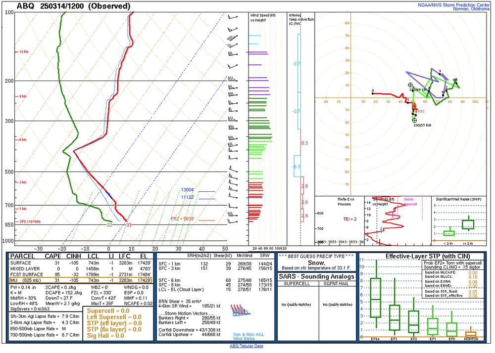
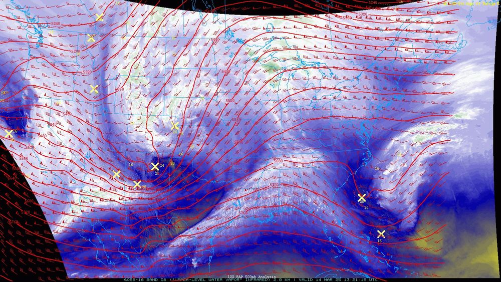
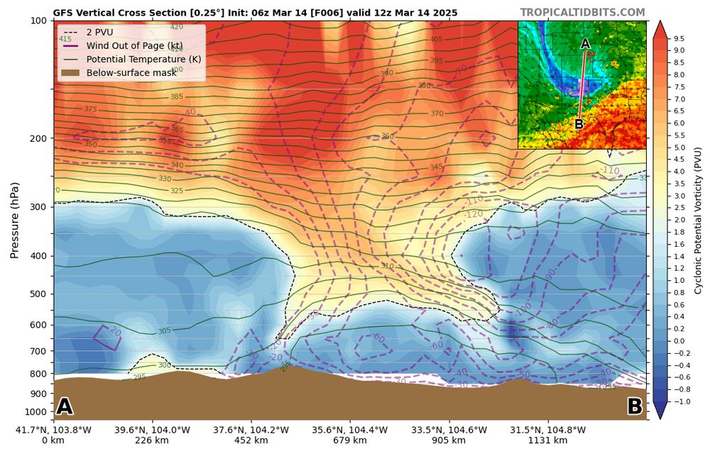
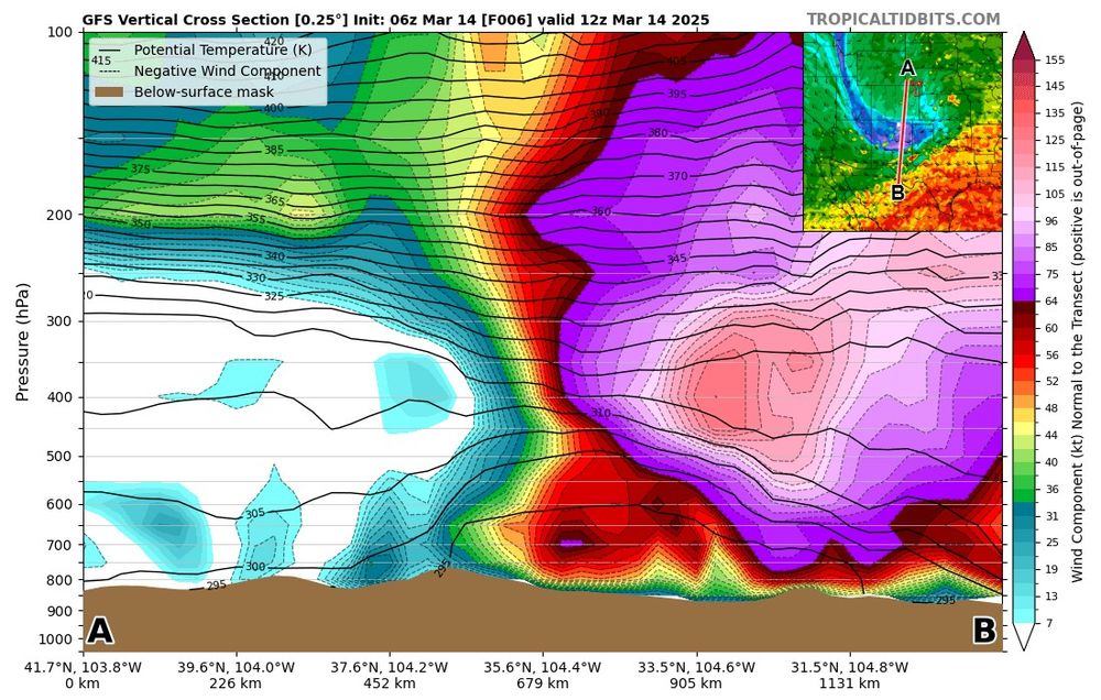
Observed ABQ sounding with a tropopause around 400mb (at 35N) in a tropopause fold! This tropopause fold is interacting with two jet streaks within the subtropical jet (seen on water vapor) while ejecting into the Plains and taking on a severe negative tilt. Just a powder keg of a synoptic setup.
March 14, 2025 at 1:38 PM
Observed ABQ sounding with a tropopause around 400mb (at 35N) in a tropopause fold! This tropopause fold is interacting with two jet streaks within the subtropical jet (seen on water vapor) while ejecting into the Plains and taking on a severe negative tilt. Just a powder keg of a synoptic setup.
This little band of fgen snow is probably a top 4 synoptic (i.e. not lake driven) snow event for northern OH this winter. A few 2.5-3.5” reports so far.
March 8, 2025 at 1:13 AM
This little band of fgen snow is probably a top 4 synoptic (i.e. not lake driven) snow event for northern OH this winter. A few 2.5-3.5” reports so far.
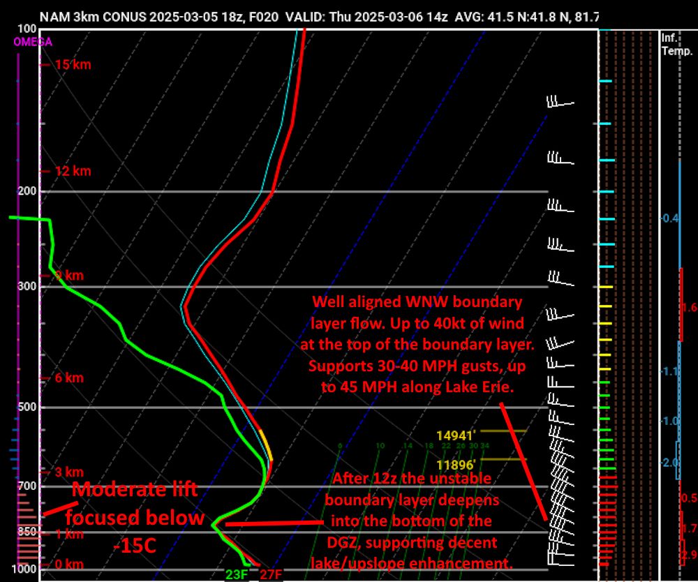
Looking at a sneaky snow event in the Cle area Thurs AM...some synoptic lift from a vort max and deformation zone, with localized "boosts" from Lake Erie and upslope as winds veer west-northwesterly. With gusts up to 40 MPH and falling temperatures, conditions could be dicey (low vis/slushy roads).


March 5, 2025 at 11:04 PM
Looking at a sneaky snow event in the Cle area Thurs AM...some synoptic lift from a vort max and deformation zone, with localized "boosts" from Lake Erie and upslope as winds veer west-northwesterly. With gusts up to 40 MPH and falling temperatures, conditions could be dicey (low vis/slushy roads).
Parts of the Ohio snowbelt got 3-6" of very fluffy lake effect snow over the last 36 hours while parts of Erie County, PA have seen 6-11" per spotter reports. This was the last clear satellite image of Lake Erie. Very high ratios helped (and somewhat limited the impact)...still interesting/tricky.

February 21, 2025 at 3:16 PM
Parts of the Ohio snowbelt got 3-6" of very fluffy lake effect snow over the last 36 hours while parts of Erie County, PA have seen 6-11" per spotter reports. This was the last clear satellite image of Lake Erie. Very high ratios helped (and somewhat limited the impact)...still interesting/tricky.
The lake enhanced snow continues to scoff at the ice on Lake Erie this morning. There’s definitely some subtle convergence focusing the snow in the vicinity of Cuyahoga County, where there have been a handful of 2-3” reports since last night.
February 20, 2025 at 3:07 PM
The lake enhanced snow continues to scoff at the ice on Lake Erie this morning. There’s definitely some subtle convergence focusing the snow in the vicinity of Cuyahoga County, where there have been a handful of 2-3” reports since last night.
Despite Lake Erie being 95% ice-covered, I’ve gotten a bit over an inch of very fluffy lake effect/enhanced snow over the last few hours. With temperatures in the low-mid 10s and about 4” of snow already on the ground, it’s quite a wintry night. Stuff like this is why I enjoy winter around here.
February 20, 2025 at 5:47 AM
Despite Lake Erie being 95% ice-covered, I’ve gotten a bit over an inch of very fluffy lake effect/enhanced snow over the last few hours. With temperatures in the low-mid 10s and about 4” of snow already on the ground, it’s quite a wintry night. Stuff like this is why I enjoy winter around here.
Pretty classic sounding for (convective) freezing rain off the HRRR near Akron, OH early this evening. Potential for heavier QPF with the convection and E-NE sfc flow (offsetting the latent heat release from rain freezing on contact) could allow a narrow corridor of 0.25"+ ice in northern OH.

February 8, 2025 at 3:34 PM
Pretty classic sounding for (convective) freezing rain off the HRRR near Akron, OH early this evening. Potential for heavier QPF with the convection and E-NE sfc flow (offsetting the latent heat release from rain freezing on contact) could allow a narrow corridor of 0.25"+ ice in northern OH.
The HRRR isn't too far off from supporting some more thunder freezing rain in northern OH late Saturday. Not quite as unstable as what we had Thursday night.
Interestingly, the NAM and most other NCEP hi-res models are way skimpier on QPF than the RAP, HRRR, and most foreign models in OH tomorrow.
Interestingly, the NAM and most other NCEP hi-res models are way skimpier on QPF than the RAP, HRRR, and most foreign models in OH tomorrow.

February 7, 2025 at 3:46 PM
The HRRR isn't too far off from supporting some more thunder freezing rain in northern OH late Saturday. Not quite as unstable as what we had Thursday night.
Interestingly, the NAM and most other NCEP hi-res models are way skimpier on QPF than the RAP, HRRR, and most foreign models in OH tomorrow.
Interestingly, the NAM and most other NCEP hi-res models are way skimpier on QPF than the RAP, HRRR, and most foreign models in OH tomorrow.