Joris Van den Bossche
@jorisvandenbossche.bsky.social
50 followers 19 following 1 posts
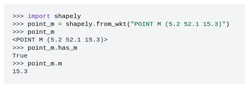
Open source #python software developer and teacher. Pandas core developer. GeoPandas and Shapely maintainer. Apache Arrow PMC. Software engineer at fused.io
Posts Media Videos Starter Packs
Reposted by Joris Van den Bossche
kylebarron.dev
Really excited for version 0.2 of GeoArrow! This has been years in the making and adds:

- Geometry, GeometryCollection, Box types. We can now represent mixed-type geometries in an array
- New ways to represent CRS.

See the release post for more information: geoarrow.org/news/release...
Reposted by Joris Van den Bossche
paleolimbot.bsky.social
We’re chuffed to announce the 0.2 release of the GeoArrow specification! We released the first version in September, 2023 and have since worked with the community towards our vision that getting spatial data from one library to another should be fast, easy, and preserve properties like the CRS.
Reposted by Joris Van den Bossche
kylebarron.dev
Published version 0.4 of the GeoArrow Rust library! It's been fully rewritten from scratch, has a much more stable core, and supports all of the GeoArrow 0.2 specification. geoarrow.org/geoarrow-rs/...
GeoArrow Rust crates - geoarrow-rs
A Rust implementation of GeoArrow
geoarrow.org
Reposted by Joris Van den Bossche
martinfleischmann.net
Ever needed to simplify street networks? I did. And it is a pain. So we wrote an algorithm that does that for us. And can do for you, as it is available as a Python package called `neatnet`.

Here's a short blog about it - martinfleischmann.net/simplificati... and package - uscuni.org/neatnet
Original network on the left, simplified one on the right. Diagram of the neatnet's workflow. Image of face artifacts.
jorisvandenbossche.bsky.social
Finally a new #Shapely feature release! 🎉
Shapely 2.1.0 highlights include initial support for geometries with M or ZM values, functionality for coverage validation and simplification, and much more.

For a full overview, see shapely.readthedocs.io/en/latest/re...

#python #geopython #geospatial
Code snippet showing the initial support for M values, illustrating that with a POINT M. Image showing the functionality of `shapely.coverage_simplify`: on the left the countries of Africa, on the right the result of topologically simplifying those polygons preserving the coverage.
Reposted by Joris Van den Bossche
stijnvanhoey.be
Second day of UGent doctoral schools "Python for GIS and Geoscience" together with @jorisvandenbossche.bsky.social. Today focus on raster data #xarray. Great to see the wide variety of backgrounds, ranging from climate science to criminology.
Computer room with participants working on code exercises in xarray.
Reposted by Joris Van den Bossche
martinfleischmann.net
I don't think I've shared with you the recording of the workshop on GeoPandas 1.0 we did with Joris Van den Bossche last year at GeoPython. So here it is - Getting the most out of GeoPandas 1.0: www.youtube.com/watch?v=6PM_...
The notebook used in the workshop lives here github.com/martinfleis/....
GeoPython 2024 Workshop: Getting the most out of GeoPandas 1.0
YouTube video by GeoPython Conference
www.youtube.com