Margot Carpenter
@margot-carto.bsky.social
550 followers 330 following 20 posts
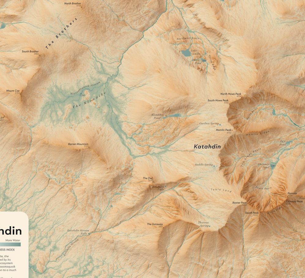
Cartographer, spatial designer, coastal GIS nerd.
Posts Media Videos Starter Packs
margot-carto.bsky.social
Just got back from some amazing surf from Gabrielle at Matunuck and the best stop was visiting with Andrew @mapcenter.com . Loved chatting carto and diving into the inspiring map collection Andrew has accrued.
Margot Carpenter and Andrew Middleton
margot-carto.bsky.social
Huge congrats and kudos to @johnnelsonmaps.bsky.social for the beautiful Spilhaus map. It's my favorite 'gift' book and your work is making a difference!
helenczerski.bsky.social
It's a huge honour to receive the Athelstan Spilhaus Award from the AGU for public engagement. But it's particularly pleasing because the Spilhaus projection was the original UK hardback cover of Blue Machine, and still the best of them all. Kudos to @davidho.bsky.social for the original suggestion.
AGU award graphics, the Spilhaus ocean map and seven Blue Machine book covers, two showing the Spilhaus projection
margot-carto.bsky.social
Exciting news! (note the MM correction of 138 million to 168 million)
themainemonitor.org
For $138 million, The Nature Conservancy will purchase the last four #dams blocking #salmon from reaching their spawning grounds in the Sandy River. To read more for free on how this affects #Maine salmon, click the link below.

themainemonitor.org/dams-sale-sa...
Historic sale of dams clears the way for salmon to return to the Kennebec River
For $138M, The Nature Conservancy will buy the last four dams blocking salmon from their spawning grounds in the Sandy River.
themainemonitor.org
margot-carto.bsky.social
With salt marshes being squeezed between rising sea levels and the built environment, this is an excellent story to follow. Variations of this have worked in Mississippi and may work in Maine. themainemonitor.org/spreading-sa...
Spreading sand to save a salt marsh
Maine researchers are using dredged materials to help a marsh better withstand sea level rise and protect endangered birds.
themainemonitor.org
margot-carto.bsky.social
Mighty comfortable near your paddle board!
margot-carto.bsky.social
Brrr! And, looking forward to listening
Reposted by Margot Carpenter
margot-carto.bsky.social
The lettering is particularly beautiful!
Reposted by Margot Carpenter
woodwellclimate.bsky.social
This #MapMonday from @maps-and-pepper.bsky.social shows the predicted return period of once-in-a-generation storms.

As climate change increases extreme weather events, we need to prepare with accurate risk information.
margot-carto.bsky.social
And, there I was, somewhere in Bhutan. Such a north up person. The map is looking nice!!!
margot-carto.bsky.social
Nice banquet of flood representation, thanks for organizing and posting. I'm not sure any say "danger" loudly enough.
margot-carto.bsky.social
Thank you @pinakographos.bsky.social !! Loved seeing this in monochrome :)
pinakographos.bsky.social
On to issue #97 (2021), where you can see a section of Margot Dale Carpenter (@margot-carto.bsky.social)'s "Sufing Saco Bay," which was also featured in the 5th Atlas of Design.

www.hartdalemaps.com
cartographicperspectives.org/index.php/jo...
The cover of an issue of Cartographic Perspectives. The top portion of the cover lists the journal name and issue date. The lower 80% or so shows a reference map of Saco Bay, with a shaded relief and landforms labeled. The whole cover is monochrome pink. A photograph of a book laid out on a wood floor. It is open to a page showing the full-color version of the Surfing Saco Bay map. Some text can also be seen on the page, describing the map.
Reposted by Margot Carpenter
pinakographos.bsky.social
On to issue #97 (2021), where you can see a section of Margot Dale Carpenter (@margot-carto.bsky.social)'s "Sufing Saco Bay," which was also featured in the 5th Atlas of Design.

www.hartdalemaps.com
cartographicperspectives.org/index.php/jo...
The cover of an issue of Cartographic Perspectives. The top portion of the cover lists the journal name and issue date. The lower 80% or so shows a reference map of Saco Bay, with a shaded relief and landforms labeled. The whole cover is monochrome pink. A photograph of a book laid out on a wood floor. It is open to a page showing the full-color version of the Surfing Saco Bay map. Some text can also be seen on the page, describing the map.
margot-carto.bsky.social
Beautiful work, the tinting is so subtle yet nuanced. A truly nice piece to have on the wall!
chaneyswiney.com
I made this giant 3x6-foot map of the #GreatSmokyMountains to hang up in our house. Worked on it in the background over a the course of a couple of years. The last touch was dialing in the hypsometric tinting, which I think finally pulled it all together.

#smokies #nationalpark #map #cartography
Image of wall map of Great Smoky Mountains National Park. Title and text in the top left, then the park fills up the core of the map with an elevation profile of the Appalachian Trail in the lower right. Green hues indicate lower elevations, tans indicate middle elevations, and the paler gray shows the highest peaks. Closeup of the area around Kuwohi (formerly Clingmans Dome) in the heart of Great Smoky Mountains National Park. Green hues indicate lower elevations, tans indicate middle elevations, and the paler gray shows the highest peaks. The purple line is the Appalachian Trail. The red line is the Mountains to Sea Trail. Closeup of the area around Mt Le Conte in Great Smoky Mountains National Park. Green hues indicate lower elevations, tans indicate middle elevations, and the paler gray shows the highest peaks. The purple line is the Appalachian Trail. Closeup of the area around Eagle Creek on the North Carolina side of Great Smoky Mountains National Park. Blue areas show arms of Fontana Lake. Green hues indicate lower elevations, tans indicate middle elevations, and the paler gray shows the highest peaks. The purple line is the Appalachian Trail. The green line is the Benton MacKaye Trail
margot-carto.bsky.social
Coffee mappy chat if you do come through :)
margot-carto.bsky.social
Yay!! Are you virtually here or ground truthing? (Mighty fine place this is :) !!)
margot-carto.bsky.social
Me, too. I've experimented with it on a few maps now but never based a complete color ramp based on that alone until now. It helps that this landscape has aretes and other glacially dramatic features.
margot-carto.bsky.social
A detail of a new Katahdin area map identifying potential water accumulation. The color is keyed to wetter or dryer. #katahdin #topographicwetness #refugia