


Earth Topo Relief Bot
@reliefbot.bsky.social
Daily topographical relief visualizations of earth.
For requests: Reply on latest post with latitude,longitude coordinates like "48.85, 2.35" (land only).
🌍 Source code: https://github.com/Bastou/bot-bluesky-reliefs
👨💻 Made by @bastiencornier.bsky.social
For requests: Reply on latest post with latitude,longitude coordinates like "48.85, 2.35" (land only).
🌍 Source code: https://github.com/Bastou/bot-bluesky-reliefs
👨💻 Made by @bastiencornier.bsky.social
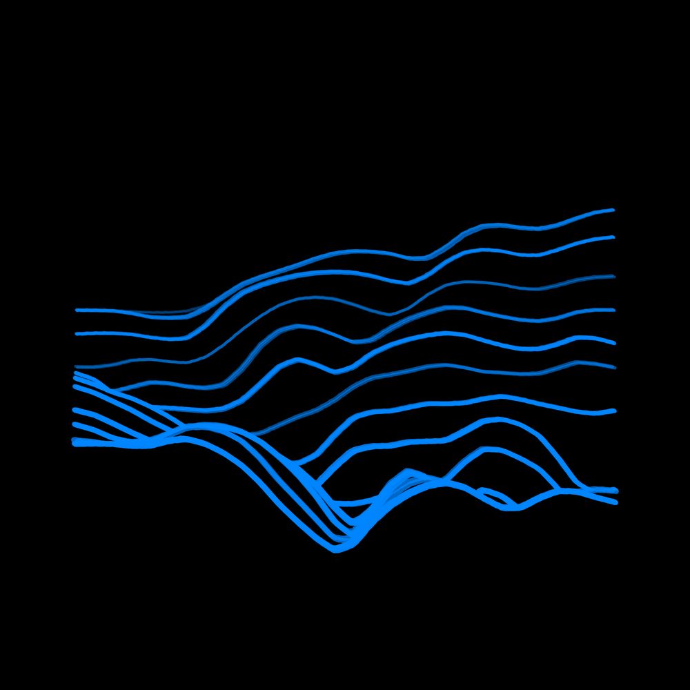
//\ Relief #175
Location: Эвенкийский район, Красноярский край, Россия
Coordinates: 64.3959, 98.7306
Elevation Range: 432m to 773m
Terrain type: hilly
#ReliefOfTheDay #DataViz #Geography
Location: Эвенкийский район, Красноярский край, Россия
Coordinates: 64.3959, 98.7306
Elevation Range: 432m to 773m
Terrain type: hilly
#ReliefOfTheDay #DataViz #Geography

November 12, 2025 at 11:10 AM
//\ Relief #175
Location: Эвенкийский район, Красноярский край, Россия
Coordinates: 64.3959, 98.7306
Elevation Range: 432m to 773m
Terrain type: hilly
#ReliefOfTheDay #DataViz #Geography
Location: Эвенкийский район, Красноярский край, Россия
Coordinates: 64.3959, 98.7306
Elevation Range: 432m to 773m
Terrain type: hilly
#ReliefOfTheDay #DataViz #Geography
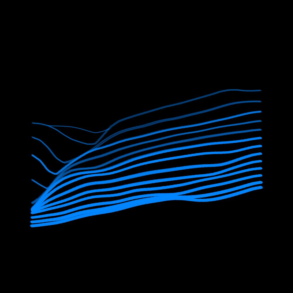
//\ Relief #174
Location: Lajeado Grande, Santa Catarina, Brasil
Coordinates: -26.8201, -52.5400
Elevation Range: 392m to 675m
Terrain type: hilly
#ReliefOfTheDay #DataViz #Geography
Location: Lajeado Grande, Santa Catarina, Brasil
Coordinates: -26.8201, -52.5400
Elevation Range: 392m to 675m
Terrain type: hilly
#ReliefOfTheDay #DataViz #Geography

November 11, 2025 at 11:11 AM
//\ Relief #174
Location: Lajeado Grande, Santa Catarina, Brasil
Coordinates: -26.8201, -52.5400
Elevation Range: 392m to 675m
Terrain type: hilly
#ReliefOfTheDay #DataViz #Geography
Location: Lajeado Grande, Santa Catarina, Brasil
Coordinates: -26.8201, -52.5400
Elevation Range: 392m to 675m
Terrain type: hilly
#ReliefOfTheDay #DataViz #Geography
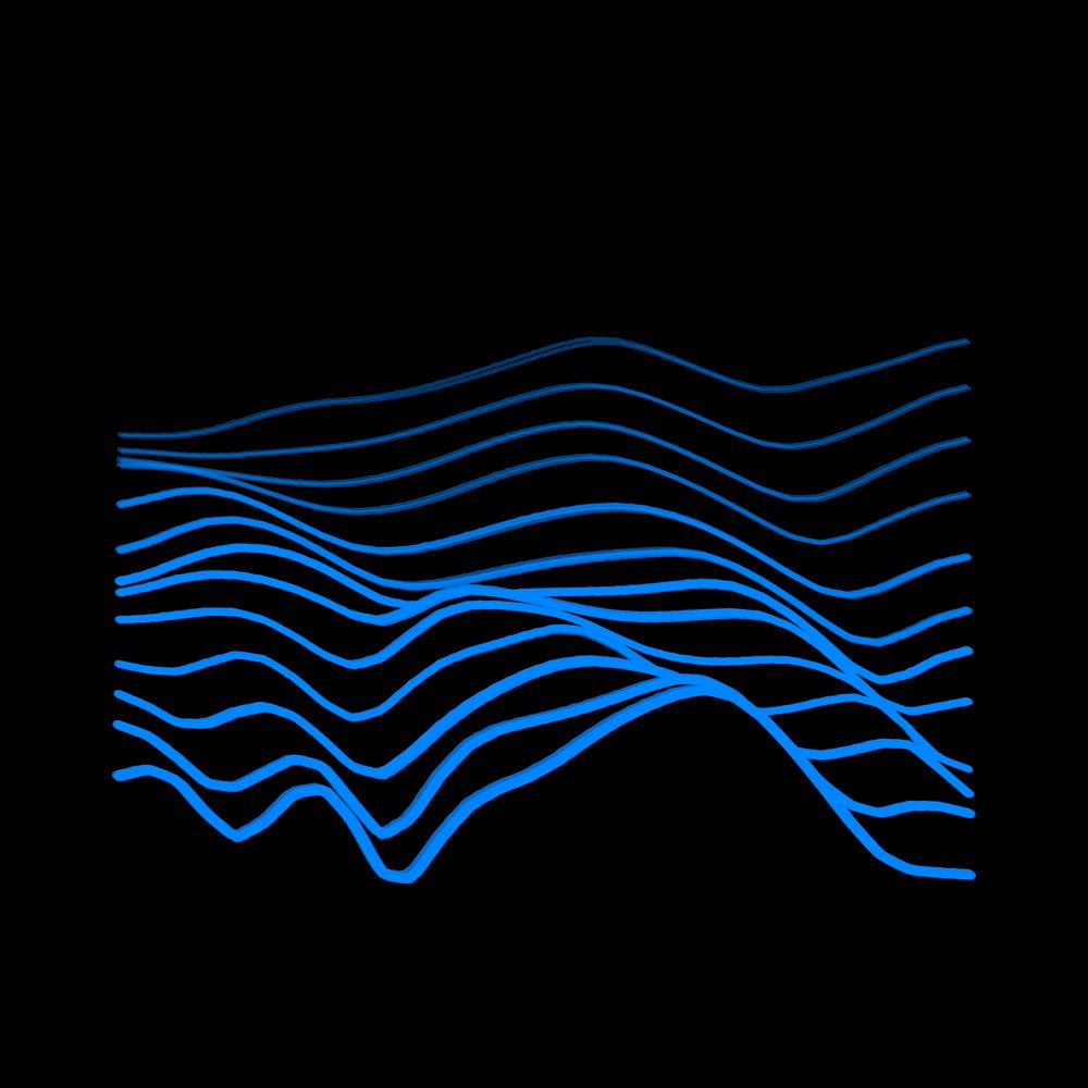
//\ Relief #173
Location: Unorganized North Algoma, Ontario, Canada
Coordinates: 48.1548, -85.1368
Elevation Range: 387m to 514m
Terrain type: rolling
#ReliefOfTheDay #DataViz #Geography
Location: Unorganized North Algoma, Ontario, Canada
Coordinates: 48.1548, -85.1368
Elevation Range: 387m to 514m
Terrain type: rolling
#ReliefOfTheDay #DataViz #Geography

November 10, 2025 at 11:10 AM
//\ Relief #173
Location: Unorganized North Algoma, Ontario, Canada
Coordinates: 48.1548, -85.1368
Elevation Range: 387m to 514m
Terrain type: rolling
#ReliefOfTheDay #DataViz #Geography
Location: Unorganized North Algoma, Ontario, Canada
Coordinates: 48.1548, -85.1368
Elevation Range: 387m to 514m
Terrain type: rolling
#ReliefOfTheDay #DataViz #Geography
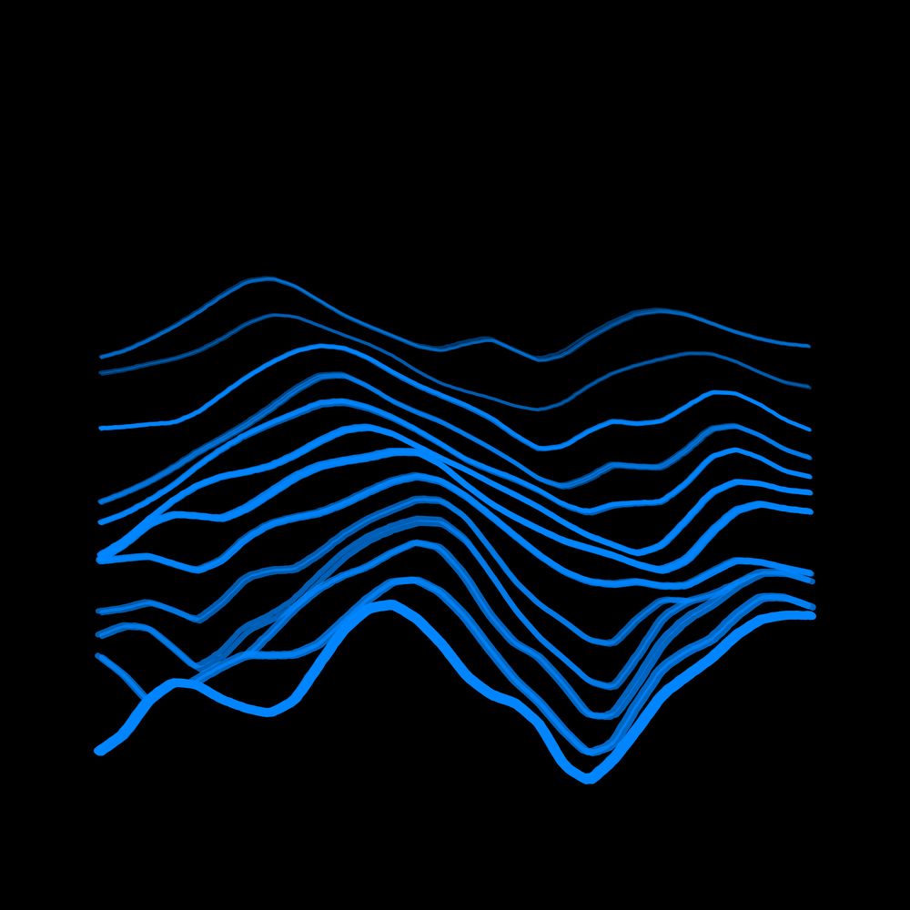
//\ Relief #172
Location: Old Inland Empire Highway, Washington, United States of America
Coordinates: 46.2632, -119.6126
Elevation Range: 151m to 576m
Terrain type: hilly
#ReliefOfTheDay #DataViz #Geography
Location: Old Inland Empire Highway, Washington, United States of America
Coordinates: 46.2632, -119.6126
Elevation Range: 151m to 576m
Terrain type: hilly
#ReliefOfTheDay #DataViz #Geography

November 9, 2025 at 11:08 AM
//\ Relief #172
Location: Old Inland Empire Highway, Washington, United States of America
Coordinates: 46.2632, -119.6126
Elevation Range: 151m to 576m
Terrain type: hilly
#ReliefOfTheDay #DataViz #Geography
Location: Old Inland Empire Highway, Washington, United States of America
Coordinates: 46.2632, -119.6126
Elevation Range: 151m to 576m
Terrain type: hilly
#ReliefOfTheDay #DataViz #Geography
//\ Relief #171
Location: Sucúa, Morona Santiago, Ecuador
Coordinates: -2.4024, -78.2814
Elevation Range: 1301m to 2738m
Terrain type: high-mountainous
#ReliefOfTheDay #DataViz #Geography
Location: Sucúa, Morona Santiago, Ecuador
Coordinates: -2.4024, -78.2814
Elevation Range: 1301m to 2738m
Terrain type: high-mountainous
#ReliefOfTheDay #DataViz #Geography

November 8, 2025 at 11:08 AM
//\ Relief #171
Location: Sucúa, Morona Santiago, Ecuador
Coordinates: -2.4024, -78.2814
Elevation Range: 1301m to 2738m
Terrain type: high-mountainous
#ReliefOfTheDay #DataViz #Geography
Location: Sucúa, Morona Santiago, Ecuador
Coordinates: -2.4024, -78.2814
Elevation Range: 1301m to 2738m
Terrain type: high-mountainous
#ReliefOfTheDay #DataViz #Geography
//\ Relief #170
Location: Тугуро-Чумиканский район, Хабаровский край, Россия
Coordinates: 53.4636, 135.7897
Elevation Range: 265m to 536m
Terrain type: hilly
#ReliefOfTheDay #DataViz #Geography
Location: Тугуро-Чумиканский район, Хабаровский край, Россия
Coordinates: 53.4636, 135.7897
Elevation Range: 265m to 536m
Terrain type: hilly
#ReliefOfTheDay #DataViz #Geography
November 7, 2025 at 11:10 AM
//\ Relief #170
Location: Тугуро-Чумиканский район, Хабаровский край, Россия
Coordinates: 53.4636, 135.7897
Elevation Range: 265m to 536m
Terrain type: hilly
#ReliefOfTheDay #DataViz #Geography
Location: Тугуро-Чумиканский район, Хабаровский край, Россия
Coordinates: 53.4636, 135.7897
Elevation Range: 265m to 536m
Terrain type: hilly
#ReliefOfTheDay #DataViz #Geography
//\ Relief #169
Location: Rivière-Mouchalagane, Québec, Canada
Coordinates: 52.5780, -69.3006
Elevation Range: 635m to 788m
Terrain type: hilly
#ReliefOfTheDay #DataViz #Geography
Location: Rivière-Mouchalagane, Québec, Canada
Coordinates: 52.5780, -69.3006
Elevation Range: 635m to 788m
Terrain type: hilly
#ReliefOfTheDay #DataViz #Geography

November 6, 2025 at 11:10 AM
//\ Relief #169
Location: Rivière-Mouchalagane, Québec, Canada
Coordinates: 52.5780, -69.3006
Elevation Range: 635m to 788m
Terrain type: hilly
#ReliefOfTheDay #DataViz #Geography
Location: Rivière-Mouchalagane, Québec, Canada
Coordinates: 52.5780, -69.3006
Elevation Range: 635m to 788m
Terrain type: hilly
#ReliefOfTheDay #DataViz #Geography
//\ Relief #168
Location: Talakag, Bukidnon, Philippines
Coordinates: 7.9506, 124.7080
Elevation Range: 1167m to 1640m
Terrain type: high-hilly
#ReliefOfTheDay #DataViz #Geography
Location: Talakag, Bukidnon, Philippines
Coordinates: 7.9506, 124.7080
Elevation Range: 1167m to 1640m
Terrain type: high-hilly
#ReliefOfTheDay #DataViz #Geography

November 5, 2025 at 11:11 AM
//\ Relief #168
Location: Talakag, Bukidnon, Philippines
Coordinates: 7.9506, 124.7080
Elevation Range: 1167m to 1640m
Terrain type: high-hilly
#ReliefOfTheDay #DataViz #Geography
Location: Talakag, Bukidnon, Philippines
Coordinates: 7.9506, 124.7080
Elevation Range: 1167m to 1640m
Terrain type: high-hilly
#ReliefOfTheDay #DataViz #Geography
//\ Relief #167
Location: Мандал ᠮᠠᠨᠳᠠᠯ, Сэлэнгэ ᠰᠡᠯᠡᠩᠭᠡ, Монгол улс ᠮᠤᠩᠭᠤᠯ ᠤᠯᠤᠰ
Coordinates: 48.6610, 106.3345
Elevation Range: 897m to 1087m
Terrain type: hilly
#ReliefOfTheDay #DataViz #Geography
Location: Мандал ᠮᠠᠨᠳᠠᠯ, Сэлэнгэ ᠰᠡᠯᠡᠩᠭᠡ, Монгол улс ᠮᠤᠩᠭᠤᠯ ᠤᠯᠤᠰ
Coordinates: 48.6610, 106.3345
Elevation Range: 897m to 1087m
Terrain type: hilly
#ReliefOfTheDay #DataViz #Geography

November 4, 2025 at 11:11 AM
//\ Relief #167
Location: Мандал ᠮᠠᠨᠳᠠᠯ, Сэлэнгэ ᠰᠡᠯᠡᠩᠭᠡ, Монгол улс ᠮᠤᠩᠭᠤᠯ ᠤᠯᠤᠰ
Coordinates: 48.6610, 106.3345
Elevation Range: 897m to 1087m
Terrain type: hilly
#ReliefOfTheDay #DataViz #Geography
Location: Мандал ᠮᠠᠨᠳᠠᠯ, Сэлэнгэ ᠰᠡᠯᠡᠩᠭᠡ, Монгол улс ᠮᠤᠩᠭᠤᠯ ᠤᠯᠤᠰ
Coordinates: 48.6610, 106.3345
Elevation Range: 897m to 1087m
Terrain type: hilly
#ReliefOfTheDay #DataViz #Geography
//\ Relief #166
Location: Παλιούρι, Αποκεντρωμένη Διοίκηση Μακεδονίας - Θράκης, Ελλάς
Coordinates: 41.3772, 26.2427
Elevation Range: 85m to 288m
Terrain type: low-hilly
#ReliefOfTheDay #DataViz #Geography
Location: Παλιούρι, Αποκεντρωμένη Διοίκηση Μακεδονίας - Θράκης, Ελλάς
Coordinates: 41.3772, 26.2427
Elevation Range: 85m to 288m
Terrain type: low-hilly
#ReliefOfTheDay #DataViz #Geography

November 3, 2025 at 11:10 AM
//\ Relief #166
Location: Παλιούρι, Αποκεντρωμένη Διοίκηση Μακεδονίας - Θράκης, Ελλάς
Coordinates: 41.3772, 26.2427
Elevation Range: 85m to 288m
Terrain type: low-hilly
#ReliefOfTheDay #DataViz #Geography
Location: Παλιούρι, Αποκεντρωμένη Διοίκηση Μακεδονίας - Θράκης, Ελλάς
Coordinates: 41.3772, 26.2427
Elevation Range: 85m to 288m
Terrain type: low-hilly
#ReliefOfTheDay #DataViz #Geography
//\ Relief #165
Location: Arsi, ኦሮሚያ ክልል Oromia أوروميا, ኢትዮጵያ إثيوبيا
Coordinates: 7.8321, 40.1027
Elevation Range: 1365m to 2517m
Terrain type: high-mountainous
#ReliefOfTheDay #DataViz #Geography
Location: Arsi, ኦሮሚያ ክልል Oromia أوروميا, ኢትዮጵያ إثيوبيا
Coordinates: 7.8321, 40.1027
Elevation Range: 1365m to 2517m
Terrain type: high-mountainous
#ReliefOfTheDay #DataViz #Geography

November 2, 2025 at 11:08 AM
//\ Relief #165
Location: Arsi, ኦሮሚያ ክልል Oromia أوروميا, ኢትዮጵያ إثيوبيا
Coordinates: 7.8321, 40.1027
Elevation Range: 1365m to 2517m
Terrain type: high-mountainous
#ReliefOfTheDay #DataViz #Geography
Location: Arsi, ኦሮሚያ ክልል Oromia أوروميا, ኢትዮጵያ إثيوبيا
Coordinates: 7.8321, 40.1027
Elevation Range: 1365m to 2517m
Terrain type: high-mountainous
#ReliefOfTheDay #DataViz #Geography
//\ Relief #164
Location: Unorganized Borough, Alaska, United States of America
Coordinates: 63.6152, -141.5115
Elevation Range: 668m to 1042m
Terrain type: hilly
#ReliefOfTheDay #DataViz #Geography
Location: Unorganized Borough, Alaska, United States of America
Coordinates: 63.6152, -141.5115
Elevation Range: 668m to 1042m
Terrain type: hilly
#ReliefOfTheDay #DataViz #Geography
November 1, 2025 at 11:08 AM
//\ Relief #164
Location: Unorganized Borough, Alaska, United States of America
Coordinates: 63.6152, -141.5115
Elevation Range: 668m to 1042m
Terrain type: hilly
#ReliefOfTheDay #DataViz #Geography
Location: Unorganized Borough, Alaska, United States of America
Coordinates: 63.6152, -141.5115
Elevation Range: 668m to 1042m
Terrain type: hilly
#ReliefOfTheDay #DataViz #Geography
//\ Relief #163
Location: Nubra tehsil, Ladakh, India
Coordinates: 35.0129, 77.7766
Elevation Range: 4822m to 6106m
Terrain type: high-mountainous
#ReliefOfTheDay #DataViz #Geography
Location: Nubra tehsil, Ladakh, India
Coordinates: 35.0129, 77.7766
Elevation Range: 4822m to 6106m
Terrain type: high-mountainous
#ReliefOfTheDay #DataViz #Geography

October 31, 2025 at 11:10 AM
//\ Relief #163
Location: Nubra tehsil, Ladakh, India
Coordinates: 35.0129, 77.7766
Elevation Range: 4822m to 6106m
Terrain type: high-mountainous
#ReliefOfTheDay #DataViz #Geography
Location: Nubra tehsil, Ladakh, India
Coordinates: 35.0129, 77.7766
Elevation Range: 4822m to 6106m
Terrain type: high-mountainous
#ReliefOfTheDay #DataViz #Geography
//\ Relief #162
Location: Карагинский район, Камчатский край, Россия
Coordinates: 57.5859, 160.7913
Elevation Range: 253m to 860m
Terrain type: hilly
#ReliefOfTheDay #DataViz #Geography
Location: Карагинский район, Камчатский край, Россия
Coordinates: 57.5859, 160.7913
Elevation Range: 253m to 860m
Terrain type: hilly
#ReliefOfTheDay #DataViz #Geography

October 30, 2025 at 11:10 AM
//\ Relief #162
Location: Карагинский район, Камчатский край, Россия
Coordinates: 57.5859, 160.7913
Elevation Range: 253m to 860m
Terrain type: hilly
#ReliefOfTheDay #DataViz #Geography
Location: Карагинский район, Камчатский край, Россия
Coordinates: 57.5859, 160.7913
Elevation Range: 253m to 860m
Terrain type: hilly
#ReliefOfTheDay #DataViz #Geography
//\ Relief #161
Location: Усойское эвенкийское сельское поселение, Республика Бурятия, Россия
Coordinates: 54.6395, 116.6272
Elevation Range: 695m to 961m
Terrain type: hilly
#ReliefOfTheDay #DataViz #Geography
Location: Усойское эвенкийское сельское поселение, Республика Бурятия, Россия
Coordinates: 54.6395, 116.6272
Elevation Range: 695m to 961m
Terrain type: hilly
#ReliefOfTheDay #DataViz #Geography

October 29, 2025 at 11:10 AM
//\ Relief #161
Location: Усойское эвенкийское сельское поселение, Республика Бурятия, Россия
Coordinates: 54.6395, 116.6272
Elevation Range: 695m to 961m
Terrain type: hilly
#ReliefOfTheDay #DataViz #Geography
Location: Усойское эвенкийское сельское поселение, Республика Бурятия, Россия
Coordinates: 54.6395, 116.6272
Elevation Range: 695m to 961m
Terrain type: hilly
#ReliefOfTheDay #DataViz #Geography
//\ Relief #160
Location: Верхнебуреинский район, Хабаровский край, Россия
Coordinates: 51.0198, 131.4356
Elevation Range: 362m to 656m
Terrain type: hilly
#ReliefOfTheDay #DataViz #Geography
Location: Верхнебуреинский район, Хабаровский край, Россия
Coordinates: 51.0198, 131.4356
Elevation Range: 362m to 656m
Terrain type: hilly
#ReliefOfTheDay #DataViz #Geography

October 28, 2025 at 11:10 AM
//\ Relief #160
Location: Верхнебуреинский район, Хабаровский край, Россия
Coordinates: 51.0198, 131.4356
Elevation Range: 362m to 656m
Terrain type: hilly
#ReliefOfTheDay #DataViz #Geography
Location: Верхнебуреинский район, Хабаровский край, Россия
Coordinates: 51.0198, 131.4356
Elevation Range: 362m to 656m
Terrain type: hilly
#ReliefOfTheDay #DataViz #Geography
//\ Relief #159
Location: Montée du Puits, Provence-Alpes-Côte d'Azur, France
Coordinates: 43.2135, 5.4418
Elevation Range: -1m to 538m
Terrain type: low-hilly
Requested by @navalu.bsky.social
#ReliefOfTheDay #DataViz #Geography
Location: Montée du Puits, Provence-Alpes-Côte d'Azur, France
Coordinates: 43.2135, 5.4418
Elevation Range: -1m to 538m
Terrain type: low-hilly
Requested by @navalu.bsky.social
#ReliefOfTheDay #DataViz #Geography

October 27, 2025 at 11:11 AM
//\ Relief #159
Location: Montée du Puits, Provence-Alpes-Côte d'Azur, France
Coordinates: 43.2135, 5.4418
Elevation Range: -1m to 538m
Terrain type: low-hilly
Requested by @navalu.bsky.social
#ReliefOfTheDay #DataViz #Geography
Location: Montée du Puits, Provence-Alpes-Côte d'Azur, France
Coordinates: 43.2135, 5.4418
Elevation Range: -1m to 538m
Terrain type: low-hilly
Requested by @navalu.bsky.social
#ReliefOfTheDay #DataViz #Geography
//\ Relief #158
Location: Rivière-Koksoak, Québec, Canada
Coordinates: 58.3491, -66.2723
Elevation Range: 56m to 222m
Terrain type: low-hilly
#ReliefOfTheDay #DataViz #Geography
Location: Rivière-Koksoak, Québec, Canada
Coordinates: 58.3491, -66.2723
Elevation Range: 56m to 222m
Terrain type: low-hilly
#ReliefOfTheDay #DataViz #Geography

October 26, 2025 at 11:09 AM
//\ Relief #158
Location: Rivière-Koksoak, Québec, Canada
Coordinates: 58.3491, -66.2723
Elevation Range: 56m to 222m
Terrain type: low-hilly
#ReliefOfTheDay #DataViz #Geography
Location: Rivière-Koksoak, Québec, Canada
Coordinates: 58.3491, -66.2723
Elevation Range: 56m to 222m
Terrain type: low-hilly
#ReliefOfTheDay #DataViz #Geography
//\ Relief #157
Location: Исинский сельсовет, Амурская область, Россия
Coordinates: 52.1859, 132.5055
Elevation Range: 737m to 1371m
Terrain type: high-hilly
#ReliefOfTheDay #DataViz #Geography
Location: Исинский сельсовет, Амурская область, Россия
Coordinates: 52.1859, 132.5055
Elevation Range: 737m to 1371m
Terrain type: high-hilly
#ReliefOfTheDay #DataViz #Geography
October 25, 2025 at 11:09 AM
//\ Relief #157
Location: Исинский сельсовет, Амурская область, Россия
Coordinates: 52.1859, 132.5055
Elevation Range: 737m to 1371m
Terrain type: high-hilly
#ReliefOfTheDay #DataViz #Geography
Location: Исинский сельсовет, Амурская область, Россия
Coordinates: 52.1859, 132.5055
Elevation Range: 737m to 1371m
Terrain type: high-hilly
#ReliefOfTheDay #DataViz #Geography
//\ Relief #156
Location: Ольский муниципальный округ, Магаданская область, Россия
Coordinates: 60.3395, 149.6511
Elevation Range: 519m to 1225m
Terrain type: hilly
#ReliefOfTheDay #DataViz #Geography
Location: Ольский муниципальный округ, Магаданская область, Россия
Coordinates: 60.3395, 149.6511
Elevation Range: 519m to 1225m
Terrain type: hilly
#ReliefOfTheDay #DataViz #Geography

October 24, 2025 at 11:10 AM
//\ Relief #156
Location: Ольский муниципальный округ, Магаданская область, Россия
Coordinates: 60.3395, 149.6511
Elevation Range: 519m to 1225m
Terrain type: hilly
#ReliefOfTheDay #DataViz #Geography
Location: Ольский муниципальный округ, Магаданская область, Россия
Coordinates: 60.3395, 149.6511
Elevation Range: 519m to 1225m
Terrain type: hilly
#ReliefOfTheDay #DataViz #Geography
//\ Relief #155
Location: 沂洲, 福建省, 中国
Coordinates: 26.5195, 116.9916
Elevation Range: 347m to 656m
Terrain type: hilly
#ReliefOfTheDay #DataViz #Geography
Location: 沂洲, 福建省, 中国
Coordinates: 26.5195, 116.9916
Elevation Range: 347m to 656m
Terrain type: hilly
#ReliefOfTheDay #DataViz #Geography

October 23, 2025 at 11:10 AM
//\ Relief #155
Location: 沂洲, 福建省, 中国
Coordinates: 26.5195, 116.9916
Elevation Range: 347m to 656m
Terrain type: hilly
#ReliefOfTheDay #DataViz #Geography
Location: 沂洲, 福建省, 中国
Coordinates: 26.5195, 116.9916
Elevation Range: 347m to 656m
Terrain type: hilly
#ReliefOfTheDay #DataViz #Geography
//\ Relief #154
Location: Rompin, Pahang, Malaysia
Coordinates: 3.2662, 102.7111
Elevation Range: 78m to 461m
Terrain type: hilly
#ReliefOfTheDay #DataViz #Geography
Location: Rompin, Pahang, Malaysia
Coordinates: 3.2662, 102.7111
Elevation Range: 78m to 461m
Terrain type: hilly
#ReliefOfTheDay #DataViz #Geography
October 22, 2025 at 11:11 AM
//\ Relief #154
Location: Rompin, Pahang, Malaysia
Coordinates: 3.2662, 102.7111
Elevation Range: 78m to 461m
Terrain type: hilly
#ReliefOfTheDay #DataViz #Geography
Location: Rompin, Pahang, Malaysia
Coordinates: 3.2662, 102.7111
Elevation Range: 78m to 461m
Terrain type: hilly
#ReliefOfTheDay #DataViz #Geography
//\ Relief #153
Location: Эвенкийский район, Красноярский край, Россия
Coordinates: 66.0557, 102.6779
Elevation Range: 569m to 729m
Terrain type: hilly
#ReliefOfTheDay #DataViz #Geography
Location: Эвенкийский район, Красноярский край, Россия
Coordinates: 66.0557, 102.6779
Elevation Range: 569m to 729m
Terrain type: hilly
#ReliefOfTheDay #DataViz #Geography

October 21, 2025 at 11:10 AM
//\ Relief #153
Location: Эвенкийский район, Красноярский край, Россия
Coordinates: 66.0557, 102.6779
Elevation Range: 569m to 729m
Terrain type: hilly
#ReliefOfTheDay #DataViz #Geography
Location: Эвенкийский район, Красноярский край, Россия
Coordinates: 66.0557, 102.6779
Elevation Range: 569m to 729m
Terrain type: hilly
#ReliefOfTheDay #DataViz #Geography
//\ Relief #152
Location: Быстринский муниципальный округ, Камчатский край, Россия
Coordinates: 55.0865, 157.8314
Elevation Range: 590m to 1347m
Terrain type: hilly
#ReliefOfTheDay #DataViz #Geography
Location: Быстринский муниципальный округ, Камчатский край, Россия
Coordinates: 55.0865, 157.8314
Elevation Range: 590m to 1347m
Terrain type: hilly
#ReliefOfTheDay #DataViz #Geography

October 20, 2025 at 11:10 AM
//\ Relief #152
Location: Быстринский муниципальный округ, Камчатский край, Россия
Coordinates: 55.0865, 157.8314
Elevation Range: 590m to 1347m
Terrain type: hilly
#ReliefOfTheDay #DataViz #Geography
Location: Быстринский муниципальный округ, Камчатский край, Россия
Coordinates: 55.0865, 157.8314
Elevation Range: 590m to 1347m
Terrain type: hilly
#ReliefOfTheDay #DataViz #Geography
//\ Relief #151
Location: Grant County, Washington, United States
Coordinates: 47.3838, -119.8859
Elevation Range: 305m to 807m
Terrain type: hilly
#ReliefOfTheDay #DataViz #Geography
Location: Grant County, Washington, United States
Coordinates: 47.3838, -119.8859
Elevation Range: 305m to 807m
Terrain type: hilly
#ReliefOfTheDay #DataViz #Geography

October 19, 2025 at 11:09 AM
//\ Relief #151
Location: Grant County, Washington, United States
Coordinates: 47.3838, -119.8859
Elevation Range: 305m to 807m
Terrain type: hilly
#ReliefOfTheDay #DataViz #Geography
Location: Grant County, Washington, United States
Coordinates: 47.3838, -119.8859
Elevation Range: 305m to 807m
Terrain type: hilly
#ReliefOfTheDay #DataViz #Geography