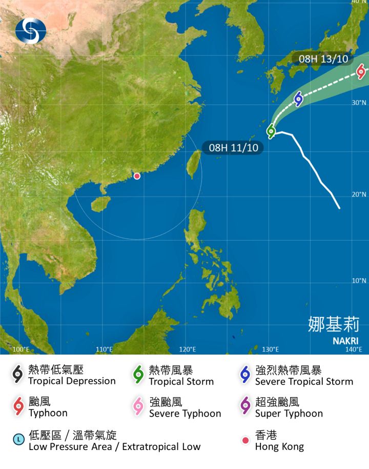
#Nakri E of #AmamiOshima#Kagoshima stay S of #Japan as it heads ENE interests esp #Kyushu#Shikoku#Kinki#Tokai#Kanto#IzuIslands#Tokyo should watch closely To peak at 85mph C1+ #typhoon #Wxx#Wxtwitter#TropicsWx#BlueSkyWx#QuedanPH#台風23号#Typhoonnakri#TropicalstormNakri#tropicalstorm
60mph #TropicalStorm#Jerry level off at this intensity moving away from #LeewardIslands #Wxx#Wxtwitter#TropicsWx#BlueSkywx#hurricaneseason#TropicalStormJerry#HurricaneSeason2025
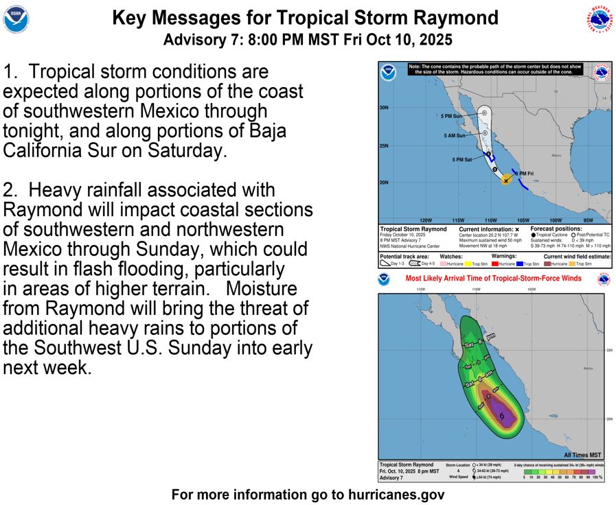
45mph #Tropicalstorm#Raymond to peak now or higher paralleling #Mexico before landfalling in #CaboSanLucas#BajaCaliforniaSur All interests there to begin preps now! #Wxx#Wxtwitter#TropicsWx#BlueSkyWx#hurricaneseason#Hurricaneseason2025#TropicalstormRaymond
D150 EPAC #HurricaneSeason2025 2am EDT new aoi has 20% chance to become a TC in 7 days and to should impact #Mexico coast; interests there have to watch closely esp after #Priscilla and #raymond #Wxx#Wxtwitter#TropicsWx#BlueSkyWx#hurricaneseason#Ep91#91e#invest91e#Sonia
D133 ATL #HurricaneSeason2025 2am EDT New AOI has 20% chance in the MDR to become a TC in 7 days and hopefully stays away from any land #Wxx#Wxtwitter#TropicsWx#BlueSkywx#hurricaneseason#Al97#invest97L#97L#Lorenzo
45mph #Tropicalstorm#Raymond to peak now or higher paralleling #Mexico before landfalling in #CaboSanLucas#BajaCaliforniaSur All interests there to begin preps now! #Wxx#Wxtwitter#TropicsWx#BlueSkyWx#hurricaneseason#Hurricaneseason2025#TropicalstormRaymond
60mph #TropicalStorm#Jerry level off at this intensity moving away from #LeewardIslands #Wxx#Wxtwitter#TropicsWx#BlueSkywx#hurricaneseason#TropicalStormJerry#HurricaneSeason2025
11PM EDT 45mph #Tropicalstorm#Raymond to peak now or higher paralleling #Mexico before landfalling in #CaboSanLucas#BajaCaliforniaSur All interests there to begin preps now! #Wxx#Wxtwitter#TropicsWx#BlueSkyWx#hurricaneseason#Hurricaneseason2025#TropicalstormRaymond
#Nakri E of #AmamiOshima#Kagoshima stay S of #Japan as it heads ENE interests esp #Kyushu#Shikoku#Kinki#Tokai#Kanto#IzuIslands#Tokyo should watch closely To peak at 85mph C1+ #typhoon #Wxx#Wxtwitter#TropicsWx#BlueSkyWx#QuedanPH#台風23号#Typhoonnakri#TropicalstormNakri#tropicalstorm
50mph #Tropicalstorm#Raymond to peak now or higher paralleling #Mexico before landfalling in #CaboSanLucas#BajaCaliforniaSur All interests there to begin preps now! #Wxx#Wxtwitter#TropicsWx#BlueSkyWx#hurricaneseason#Hurricaneseason2025#TropicalstormRaymond
50mph #TropicalStorm#Jerry level off at this intensity moving away from #LeewardIslands #Wxx#Wxtwitter#TropicsWx#BlueSkywx#hurricaneseason#TropicalStormJerry#HurricaneSeason2025
50mph #Tropicalstorm#Raymond to peak now or higher paralleling #Mexico before landfalling in #CaboSanLucas#BajaCaliforniaSur All interests there to begin preps now! #Wxx#Wxtwitter#TropicsWx#BlueSkyWx#hurricaneseason#Hurricaneseason2025#TropicalstormRaymond
2PM EDT 60mph #Tropicalstorm#Raymond to peak now or higher paralleling #Mexico before landfalling in #CaboSanLucas#BajaCaliforniaSur All interests there to begin preps now! #Wxx#Wxtwitter#TropicsWx#BlueSkyWx#hurricaneseason#Hurricaneseason2025#TropicalstormRaymond
#Nakri to head NW then ENE E of #AmamiOshima#Kagoshima stay S of #Japan interests esp #Kyushu#Shikoku#Kinki#Tokai#Kanto#IzuIslands#Tokyo should watch closely To peak at 90mph C1+ #typhoon #Wxx#Wxtwitter#TropicsWx#BlueSkyWx#QuedanPH#台風23号#Typhoonnakri#TropicalstormNakri#tropicalstorm
#Priscilla now post tropical to impact NW #Mexico#Arizona#Utah#Colorado with #Flooding rains/ #mudslides Interests to finish prep #Wxx#wxtwitter#Tropicswx#BlueSkywx#Hurricaneseason#Hurricaneseason2025#Tropicalstormpriscilla#Azwx#Utwx#hurricanepriscilla#Cowx#tropicalstorm#Hurricane
#Subtropicalstorm#Karen at 45mph and should remain a fish storm throughout its life! #Wxx#Wxtwitter#BlueSkywx#Subtropicalstormkaren#Hurricaneseason#Hurricaneseason2025
60mph #Tropicalstorm#Raymond to peak now or higher paralleling #Mexico before landfalling in #CaboSanLucas#BajaCaliforniaSur All interests there to begin preps now! #Wxx#Wxtwitter#TropicsWx#BlueSkyWx#hurricaneseason#Hurricaneseason2025#TropicalstormRaymond
#Nakri to head NW then ENE E of #AmamiOshima#Kagoshima stay S of #Japan interests esp #Kyushu#Shikoku#Kinki#Tokai#Kanto#IzuIslands#Tokyo should watch closely To peak at 85mph C1+ #typhoon #Wxx#Wxtwitter#TropicsWx#BlueSkyWx#QuedanPH#台風23号#Typhoonnakri#TropicalstormNakri#tropicalstorm
#Priscilla down to 45mph to impact NW #Mexico#Arizona#Utah#Colorado with #Flooding rains/ #mudslides Interests to finish prep #Wxx#wxtwitter#Tropicswx#BlueSkywx#Hurricaneseason#Hurricaneseason2025#Tropicalstormpriscilla#Azwx#Utwx#hurricanepriscilla#Cowx#tropicalstorm#Hurricane
50mph #TropicalStorm#Jerry to peak 60mph or even higher moving away from #LeewardIslands #Wxx#Wxtwitter#TropicsWx#BlueSkywx#hurricaneseason#TropicalStormJerry#HurricaneSeason2025
60mph #Tropicalstorm#Raymond to peak now or higher paralleling #Mexico before landfalling in #CaboSanLucas#BajaCaliforniaSur All interests there to begin preps now! #Wxx#Wxtwitter#TropicsWx#BlueSkyWx#hurricaneseason#Hurricaneseason2025#TropicalstormRaymond
50mph #TropicalStorm#Jerry to peak 70mph or even C1 #Hurricane to impact #LeewardIslands Interests to finish preps #Wxx#Wxtwitter#TropicsWx#BlueSkywx#hurricaneseason#antigua#Barbuda#Anguilla#StKittsandNevis#StMartin#Montserrat#TropicalStormJerry#HurricaneJerry#HurricaneSeason2025