


Kaylan Patel
@wxpatel.bsky.social
Someone who studied the weather
University of Wisconsin AOS 🇨🇦🇺🇸
University of Wisconsin AOS 🇨🇦🇺🇸
Another way to visualize sondes rotating to other quadrants in smaller eyes is on a map. You can see the normal flight path into #Erin in the "X" path while the sondes they drop along the way rotate cyclonically around the <5km pinhole eye.

August 23, 2025 at 5:43 PM
Another way to visualize sondes rotating to other quadrants in smaller eyes is on a map. You can see the normal flight path into #Erin in the "X" path while the sondes they drop along the way rotate cyclonically around the <5km pinhole eye.
It's genuinely impressive how prominent the Canadian Wildfires are this early in the season. With dozens already burning across the Canadian Shield and Interior Plains, 2025 is shaping up to become another notable season for areas that have been hit hard in recent years.


June 2, 2025 at 11:14 PM
It's genuinely impressive how prominent the Canadian Wildfires are this early in the season. With dozens already burning across the Canadian Shield and Interior Plains, 2025 is shaping up to become another notable season for areas that have been hit hard in recent years.
A fairly benign EWB has traversed across the Pacific over the last week and in the process was able to upwell the shallow warm pool across Nino1.2. In just a few days, the area off Peru has cooled by 2C with cooling extending into the Nino3 region.


April 21, 2025 at 1:35 AM
A fairly benign EWB has traversed across the Pacific over the last week and in the process was able to upwell the shallow warm pool across Nino1.2. In just a few days, the area off Peru has cooled by 2C with cooling extending into the Nino3 region.
The stratospheric polar vortex is set to weaken further in the coming days putting the 10mb u-wind near -30m/s. That value would represent the strongest reversal since the SSW of March 2016 and greatest reversal so late in the season since MERRA2 records began in the 1970s.

March 25, 2025 at 10:42 PM
The stratospheric polar vortex is set to weaken further in the coming days putting the 10mb u-wind near -30m/s. That value would represent the strongest reversal since the SSW of March 2016 and greatest reversal so late in the season since MERRA2 records began in the 1970s.
-Back to back days with events
-Early CI
-Rapid motions
-Dixie
-First event of the year
… The storm chasing incident page will likely begin early this year
-Early CI
-Rapid motions
-Dixie
-First event of the year
… The storm chasing incident page will likely begin early this year
March 14, 2025 at 5:58 PM
-Back to back days with events
-Early CI
-Rapid motions
-Dixie
-First event of the year
… The storm chasing incident page will likely begin early this year
-Early CI
-Rapid motions
-Dixie
-First event of the year
… The storm chasing incident page will likely begin early this year
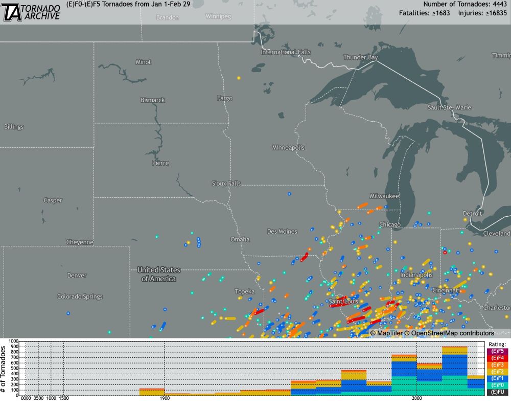
This tornado was *probably* the furthest north one was seen in either January & February east of the Rockies and in the top 5 furthest north for the month of December.

February 25, 2025 at 12:38 AM
This tornado was *probably* the furthest north one was seen in either January & February east of the Rockies and in the top 5 furthest north for the month of December.
The all-time snow-depth for Toronto is 67cm that was set during the winter of 1998-99. With 32cm on the ground currently and another 30-50cm on the way through this weekend, the city has a very good chance of nearing if not surpassing that total by storm's end.

February 15, 2025 at 6:29 PM
The all-time snow-depth for Toronto is 67cm that was set during the winter of 1998-99. With 32cm on the ground currently and another 30-50cm on the way through this weekend, the city has a very good chance of nearing if not surpassing that total by storm's end.
The ECMWF Annual ENSO Plumes came out earlier this week and there is general consensus through the spring predictability barrier reaching neutral warm/weak ENSO+, but beyond that a whole assortment of possibilities exist as we head into the second half of 2025.

February 7, 2025 at 2:02 AM
The ECMWF Annual ENSO Plumes came out earlier this week and there is general consensus through the spring predictability barrier reaching neutral warm/weak ENSO+, but beyond that a whole assortment of possibilities exist as we head into the second half of 2025.
A week later and the GFS is still holding strong on a potential PV disruption later this month. Substantial eddy flux anomalies originating across Asia will push into the Stratosphere which should weaken the Polar Vortex heading into Mid-February.

February 1, 2025 at 11:00 PM
A week later and the GFS is still holding strong on a potential PV disruption later this month. Substantial eddy flux anomalies originating across Asia will push into the Stratosphere which should weaken the Polar Vortex heading into Mid-February.
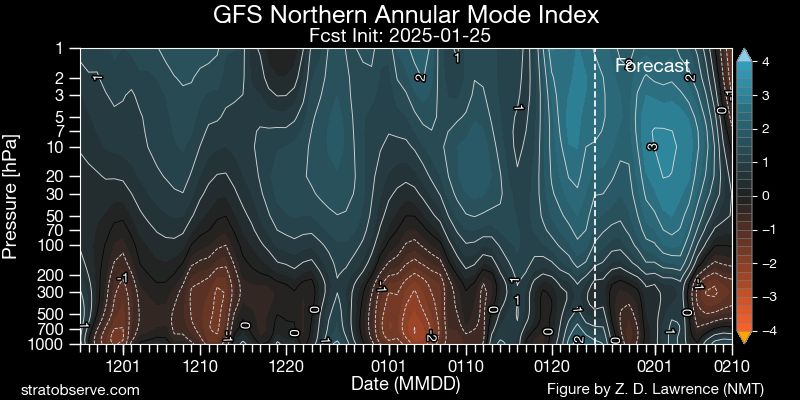
I'd keep an eye on PV shenanigans as we head enter February. The GFS is showing substantial heat flux anomalies into the stratosphere during the early part of February. As a result the AM, looks to flip back negative and could couple with the troposphere later in Feb or March.

January 26, 2025 at 4:57 PM
I'd keep an eye on PV shenanigans as we head enter February. The GFS is showing substantial heat flux anomalies into the stratosphere during the early part of February. As a result the AM, looks to flip back negative and could couple with the troposphere later in Feb or March.
One of the goofiest snow depth maps in recent memory. Snow belts along the Gulf Coast, I-70, I-94, the two coasts and nothing in between.

January 22, 2025 at 11:43 PM
One of the goofiest snow depth maps in recent memory. Snow belts along the Gulf Coast, I-70, I-94, the two coasts and nothing in between.


What's different about this upcoming -NAO/-AO event is that there will be minimal connection to the Stratospheric Polar Vortex. The forcing for these teleconnection phases and subsequent cold/snow chances are fully forced by external influences (MJO/Tropical/etc).


December 31, 2024 at 12:49 AM
What's different about this upcoming -NAO/-AO event is that there will be minimal connection to the Stratospheric Polar Vortex. The forcing for these teleconnection phases and subsequent cold/snow chances are fully forced by external influences (MJO/Tropical/etc).
3 weeks later and the state of the Pacific has changed drastically towards the colder. Not only have the surface SSTs fallen 1C in this time frame, but equally as notable is that the subsurface cold pool has substantially grown in just weeks with a connection to the surface.


December 24, 2024 at 9:09 PM
3 weeks later and the state of the Pacific has changed drastically towards the colder. Not only have the surface SSTs fallen 1C in this time frame, but equally as notable is that the subsurface cold pool has substantially grown in just weeks with a connection to the surface.
Analogs centred about early January certainly favour a cold and active storm track across the Mid-Atlantic/Northeast. Details on the potential impacts are still far too murky this far out but the pattern as a whole is quite favourable for wintry weather in those areas.


December 23, 2024 at 2:47 AM
Analogs centred about early January certainly favour a cold and active storm track across the Mid-Atlantic/Northeast. Details on the potential impacts are still far too murky this far out but the pattern as a whole is quite favourable for wintry weather in those areas.
Unsurprisingly the Farmers Almanac will be wrong once again. Beating a dead horse here, but it should be said once again that it should not to be used for predictions of any sort. There is absolutely no basis to their forecasts.

December 16, 2024 at 11:29 PM
Unsurprisingly the Farmers Almanac will be wrong once again. Beating a dead horse here, but it should be said once again that it should not to be used for predictions of any sort. There is absolutely no basis to their forecasts.
For the next 10-14 days we will see the effects of a PT regime across the Pacific-North America region. With the jet stream extended (+EPO) and arching poleward (+PNA) the chances for a sustained cold air outbreak is slim.


December 11, 2024 at 12:00 AM
For the next 10-14 days we will see the effects of a PT regime across the Pacific-North America region. With the jet stream extended (+EPO) and arching poleward (+PNA) the chances for a sustained cold air outbreak is slim.
Even though the SSTs across the Pacific don't reach La Niña criteria, a standing wave such as this is usually indicative of an atmosphere that is coupled to -ENSO. As a result, we will see the -IOD/-ENSO connection strengthen through the EWBs in the PAC and WWBs in the IO.


December 4, 2024 at 1:43 AM
Even though the SSTs across the Pacific don't reach La Niña criteria, a standing wave such as this is usually indicative of an atmosphere that is coupled to -ENSO. As a result, we will see the -IOD/-ENSO connection strengthen through the EWBs in the PAC and WWBs in the IO.
When you combine the record warm Great Lakes and a polar airmass giving a ΔT of >20C, a significant lake effect usually follows. Models are already highlighting cyclonic flow with long fetches across each of the lakes to start December with a bang.


November 25, 2024 at 5:35 PM
When you combine the record warm Great Lakes and a polar airmass giving a ΔT of >20C, a significant lake effect usually follows. Models are already highlighting cyclonic flow with long fetches across each of the lakes to start December with a bang.
The beginning of December looks to bring us our first true taste of Winter. Long fetched cross-polar flow tied to a staunch -WPO/-EPO combo will facilitate strong northerly flow from the heart of the Arctic directed towards the CONUS.

November 22, 2024 at 11:02 PM
The beginning of December looks to bring us our first true taste of Winter. Long fetched cross-polar flow tied to a staunch -WPO/-EPO combo will facilitate strong northerly flow from the heart of the Arctic directed towards the CONUS.
The storm is everything as advertised and much more. Through today the storm bombed out and is now a fully matured storm off the Western Coast of North America. Through this, we have got spectacular imagery of the storm as it's pressure cratered over the last 24 hours.


November 19, 2024 at 11:49 PM
The storm is everything as advertised and much more. Through today the storm bombed out and is now a fully matured storm off the Western Coast of North America. Through this, we have got spectacular imagery of the storm as it's pressure cratered over the last 24 hours.
Off the West Coast of North America a quite potent cyclogenesis event is about to occur early next week. A innocuous 1012mb disturbance - currently over the Central Pacific, is set to cut across a 150kt+ jet streak allowing it to explosively deepen 60mb in just 24 hours.

November 15, 2024 at 10:22 PM
Off the West Coast of North America a quite potent cyclogenesis event is about to occur early next week. A innocuous 1012mb disturbance - currently over the Central Pacific, is set to cut across a 150kt+ jet streak allowing it to explosively deepen 60mb in just 24 hours.
#99L is primed to undergo TCG in the next 24-36 hours. Healthy convection has persisted across the northern half of the sharp wave axis extending NE/SW across the Caribbean. It is the under the convection SE of Jamaica where a nascent LLC will form sooner rather than later.

November 12, 2024 at 11:26 PM
#99L is primed to undergo TCG in the next 24-36 hours. Healthy convection has persisted across the northern half of the sharp wave axis extending NE/SW across the Caribbean. It is the under the convection SE of Jamaica where a nascent LLC will form sooner rather than later.
Might be using this account more often here on out...
November 6, 2024 at 7:32 PM
Might be using this account more often here on out...
Quite the NPJ extension...


December 11, 2023 at 4:42 PM
Quite the NPJ extension...