


Kaylan Patel
@wxpatel.bsky.social
Someone who studied the weather
University of Wisconsin AOS 🇨🇦🇺🇸
University of Wisconsin AOS 🇨🇦🇺🇸
At this time, 6-12ish hours after Erin peak, the PBL was mixing very well with the highest recorded winds occurring at the end of the dropsonde rotations when it was actually closest to the surface.
August 23, 2025 at 5:43 PM
At this time, 6-12ish hours after Erin peak, the PBL was mixing very well with the highest recorded winds occurring at the end of the dropsonde rotations when it was actually closest to the surface.
It's hard to say what the impacts are beyond just the SSTs. As it stands, the atmosphere in the region is still coupled to the prior +TNI with rising favoured in the region. That being said, moving forward as the atmosphere reacts to a more canonical cold-tilt TNI, is TBD.

April 21, 2025 at 1:35 AM
It's hard to say what the impacts are beyond just the SSTs. As it stands, the atmosphere in the region is still coupled to the prior +TNI with rising favoured in the region. That being said, moving forward as the atmosphere reacts to a more canonical cold-tilt TNI, is TBD.
In the long term this is just another complexity in the Spring Predictability Barrier moving forward. SSTs have dropped from a convective temperature (27-28C) to one that is not supportive of convection (24-25C) across the equatorial cold tongue region.

April 21, 2025 at 1:35 AM
In the long term this is just another complexity in the Spring Predictability Barrier moving forward. SSTs have dropped from a convective temperature (27-28C) to one that is not supportive of convection (24-25C) across the equatorial cold tongue region.
didn't post this at 11:30 so I'm rescinding my like
February 25, 2025 at 2:09 AM
didn't post this at 11:30 so I'm rescinding my like
TPG also denotes that there were tornadoes the Southern Plains/Dixie which aligns well with the cyclone's warm sector as it moved eastward. There's just the outlier in Northern Minnesota which doesn't align with the other factors at hand which leads me to believe it's not right.

February 25, 2025 at 12:38 AM
TPG also denotes that there were tornadoes the Southern Plains/Dixie which aligns well with the cyclone's warm sector as it moved eastward. There's just the outlier in Northern Minnesota which doesn't align with the other factors at hand which leads me to believe it's not right.
Weather charts from Feb 22 and Feb 23 1909 show a low pressure system tracking across the Central Plains with 8am temperatures in the cold sector ranging from 10F to 20F. The warmest Moorhead (located 50 miles SW of the tornado) got over the time frame was only 28F and no precip.


February 25, 2025 at 12:38 AM
Weather charts from Feb 22 and Feb 23 1909 show a low pressure system tracking across the Central Plains with 8am temperatures in the cold sector ranging from 10F to 20F. The warmest Moorhead (located 50 miles SW of the tornado) got over the time frame was only 28F and no precip.
I say probably because you might see that singular dot in NW Minnesota which according to Grazuli was an F2 that occurred at 2:30am on February 23rd 1909. Now I don't doubt the man but I think either the date or location is wrong for that particular tornado.
February 25, 2025 at 12:38 AM
I say probably because you might see that singular dot in NW Minnesota which according to Grazuli was an F2 that occurred at 2:30am on February 23rd 1909. Now I don't doubt the man but I think either the date or location is wrong for that particular tornado.
We'll have to see where exactly the rain/snow line sets up and whether it's along the QEW corridor or closer to the 407 corridor. Furthermore we'll have to see how much the high winds affect not only the SLR but also how the snow is measured on the snowboard.
February 15, 2025 at 6:29 PM
We'll have to see where exactly the rain/snow line sets up and whether it's along the QEW corridor or closer to the 407 corridor. Furthermore we'll have to see how much the high winds affect not only the SLR but also how the snow is measured on the snowboard.
Woke DEI cars has hit the ski slopes :(
February 8, 2025 at 6:56 PM
Woke DEI cars has hit the ski slopes :(
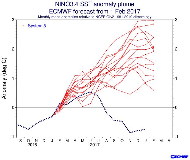
Feb 2017: Predicted strong El Niño -> got La Niña instead
Feb 2020: Predicted Warm Neutral -> got La Niña
Feb 2021: Predicted Neutral -> got double dip La Niña
Feb 2022: Predicted Neutral -> got triple dip La Niña
Feb 2020: Predicted Warm Neutral -> got La Niña
Feb 2021: Predicted Neutral -> got double dip La Niña
Feb 2022: Predicted Neutral -> got triple dip La Niña


February 7, 2025 at 2:02 AM
Feb 2017: Predicted strong El Niño -> got La Niña instead
Feb 2020: Predicted Warm Neutral -> got La Niña
Feb 2021: Predicted Neutral -> got double dip La Niña
Feb 2022: Predicted Neutral -> got triple dip La Niña
Feb 2020: Predicted Warm Neutral -> got La Niña
Feb 2021: Predicted Neutral -> got double dip La Niña
Feb 2022: Predicted Neutral -> got triple dip La Niña
Beyond that I'd take the output with a grain of salt due to the aforementioned Spring Predictability Barrier. There are have been a few FEB runs in the past where it's been quite far off in it's prediction compared to what actually transpired in a similar La Niña transition phase
February 7, 2025 at 2:02 AM
Beyond that I'd take the output with a grain of salt due to the aforementioned Spring Predictability Barrier. There are have been a few FEB runs in the past where it's been quite far off in it's prediction compared to what actually transpired in a similar La Niña transition phase
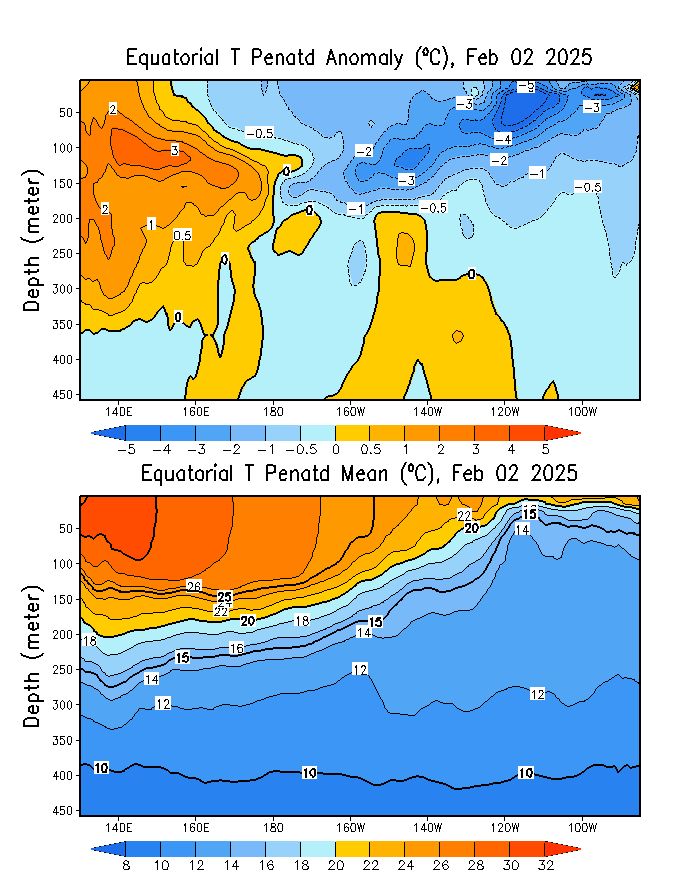
With a growing warm pool west of the IDL and a period of weaker trade winds across the EQPAC, we should see a DKW and/or a weakening in the cold pool. This would align with the decay that the ECMWF Plumes show through the next few weeks.

February 7, 2025 at 2:02 AM
With a growing warm pool west of the IDL and a period of weaker trade winds across the EQPAC, we should see a DKW and/or a weakening in the cold pool. This would align with the decay that the ECMWF Plumes show through the next few weeks.
For some reason the graphic above should be a gif but it's apparently a png on Bsky :(
February 1, 2025 at 11:03 PM
For some reason the graphic above should be a gif but it's apparently a png on Bsky :(
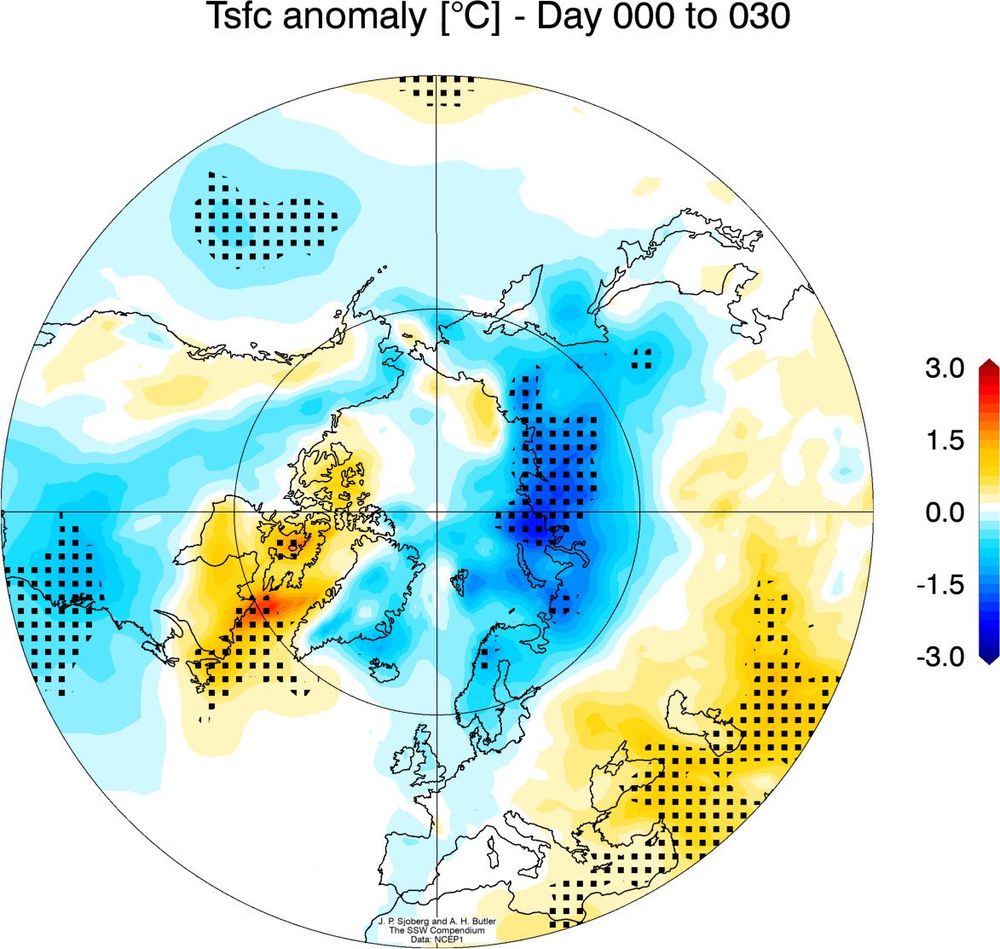
Why does this matter? If we do get a strato/tropo coupled SSW, the 30 days following it tend to be quite cold and snowy across North America and Europe. A strong -NAO/-AO sets up allowing for polar air to filter into the mid-latitudes for extended periods of time.

February 1, 2025 at 11:00 PM
Why does this matter? If we do get a strato/tropo coupled SSW, the 30 days following it tend to be quite cold and snowy across North America and Europe. A strong -NAO/-AO sets up allowing for polar air to filter into the mid-latitudes for extended periods of time.
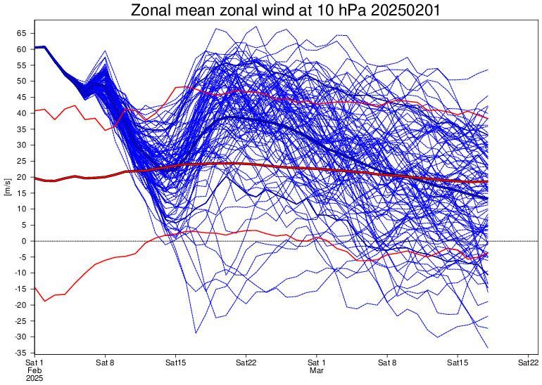
GEFS and EPS are not as excited on the prospects of a full blown SSW but agree on the PV weakening from record strong to normal levels in a few weeks time. It should be noted that they tend to have a strong vortex bias so take it with a grain of salt.

February 1, 2025 at 11:00 PM
GEFS and EPS are not as excited on the prospects of a full blown SSW but agree on the PV weakening from record strong to normal levels in a few weeks time. It should be noted that they tend to have a strong vortex bias so take it with a grain of salt.
As it stands, the GFS is the most aggressive with a major SSW with a complete reversal of winds at 10mb over the North Pole. Furthermore, it shows a complete coupling of the stratosphere and troposphere suggesting that impacts would be felt at the surface.
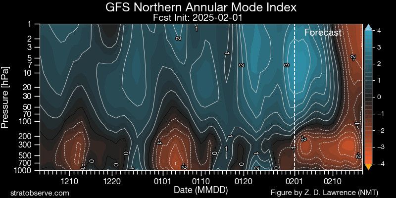

February 1, 2025 at 11:00 PM
As it stands, the GFS is the most aggressive with a major SSW with a complete reversal of winds at 10mb over the North Pole. Furthermore, it shows a complete coupling of the stratosphere and troposphere suggesting that impacts would be felt at the surface.