


Flatgeobuf on-demand vector tiling performance on a $5 4-core server *almost* good enough. The FGB process uses http range requests with minimal latency as the data host is the web server not a cloud bucket. More/faster server cores (my m2 Mac) make it much more viable. #gis #gischat #webmaps #cng
May 4, 2025 at 12:27 PM

Visualització interactiva d'arxius FlatGeobuf al navegador web, per inspeccionar els arxius i veure les propietats de les geometries i les metadades del fitxer
https://do-me.github.io/flatgeobuf-viewer/
https://do-me.github.io/flatgeobuf-viewer/

July 15, 2025 at 4:28 AM
Visualització interactiva d'arxius FlatGeobuf al navegador web, per inspeccionar els arxius i veure les propietats de les geometries i les metadades del fitxer
https://do-me.github.io/flatgeobuf-viewer/
https://do-me.github.io/flatgeobuf-viewer/

In my head, I envision a FlatGeoBuff to be like Flat Stanley, but a cartoon buffalo instead (because "buff" must be short for buffalo?). Just imagine my disappointment in the utter lack of buffalo images in the documentation. guide.cloudnativegeo.org/flatgeobuf/i...
November 9, 2023 at 11:56 PM
In my head, I envision a FlatGeoBuff to be like Flat Stanley, but a cartoon buffalo instead (because "buff" must be short for buffalo?). Just imagine my disappointment in the utter lack of buffalo images in the documentation. guide.cloudnativegeo.org/flatgeobuf/i...

Turns out what I found was the flatgeobuf format. Looks like it has a translator in the OGC package, so I will have to give that a shot for converting small datasets to for use on the web.
Too much new stuff to keep up with! 😊
flatgeobuf.org
Too much new stuff to keep up with! 😊
flatgeobuf.org
FlatGeobuf
A performant binary encoding for geographic data based on flatbuffers
flatgeobuf.org
March 19, 2025 at 3:19 PM
Turns out what I found was the flatgeobuf format. Looks like it has a translator in the OGC package, so I will have to give that a shot for converting small datasets to for use on the web.
Too much new stuff to keep up with! 😊
flatgeobuf.org
Too much new stuff to keep up with! 😊
flatgeobuf.org

OpenStreetMap tiles powered by @flatgeobuf
November 21, 2024 at 10:09 PM
OpenStreetMap tiles powered by @flatgeobuf
Made a few updates to the Potocki Vodka store finder - one of a handful of my maps in the wild - speed improvements thanks to #flatgeobuf and a few other tweaks - updates live soon - potockivodka.com/store-finder/

November 14, 2024 at 6:09 PM
Made a few updates to the Potocki Vodka store finder - one of a handful of my maps in the wild - speed improvements thanks to #flatgeobuf and a few other tweaks - updates live soon - potockivodka.com/store-finder/

I'm not sure you can create a flatgeobuf file that doesn't have a spatial index
November 20, 2024 at 1:48 AM
I'm not sure you can create a flatgeobuf file that doesn't have a spatial index

Quick test of streaming a bounding box data from a FlatGeoBuf on S3 - works a treat and loads almost instantly!
Haven't been able to compare against GeoParquet yet as it's more complicated to load from the cloud vs. locally using geopandas, but already this is a huge improvement! 👏
Haven't been able to compare against GeoParquet yet as it's more complicated to load from the cloud vs. locally using geopandas, but already this is a huge improvement! 👏

November 20, 2024 at 4:12 AM
Quick test of streaming a bounding box data from a FlatGeoBuf on S3 - works a treat and loads almost instantly!
Haven't been able to compare against GeoParquet yet as it's more complicated to load from the cloud vs. locally using geopandas, but already this is a huge improvement! 👏
Haven't been able to compare against GeoParquet yet as it's more complicated to load from the cloud vs. locally using geopandas, but already this is a huge improvement! 👏
Seems like it is optional, according to this: guide.cloudnativegeo.org/flatgeobuf/h...
But not sure how you go about configuring that with `geopandas` (maybe some `fiona` kwarg perhaps).
For now I'm going to assume it's working - things seem super speedy so far!
But not sure how you go about configuring that with `geopandas` (maybe some `fiona` kwarg perhaps).
For now I'm going to assume it's working - things seem super speedy so far!
Cloud-Optimized Geospatial Formats Guide - FlatGeobuf Spatial Index
guide.cloudnativegeo.org
November 20, 2024 at 1:52 AM
Seems like it is optional, according to this: guide.cloudnativegeo.org/flatgeobuf/h...
But not sure how you go about configuring that with `geopandas` (maybe some `fiona` kwarg perhaps).
For now I'm going to assume it's working - things seem super speedy so far!
But not sure how you go about configuring that with `geopandas` (maybe some `fiona` kwarg perhaps).
For now I'm going to assume it's working - things seem super speedy so far!

geoimport is a JavaScript library based on gdal3.js.
It allows to convert geospatial data (TopoJSON, Shapefile, Geopackage, GML, KML, GPX, FlatGeobuf, CSV, ODS & XLSX) to and from GeoJSON format. Practical and essential 🥰
code: github.com/riatelab/geo...
demo: observablehq.com/@mthh/hello-...
It allows to convert geospatial data (TopoJSON, Shapefile, Geopackage, GML, KML, GPX, FlatGeobuf, CSV, ODS & XLSX) to and from GeoJSON format. Practical and essential 🥰
code: github.com/riatelab/geo...
demo: observablehq.com/@mthh/hello-...
May 19, 2025 at 10:37 AM
geoimport is a JavaScript library based on gdal3.js.
It allows to convert geospatial data (TopoJSON, Shapefile, Geopackage, GML, KML, GPX, FlatGeobuf, CSV, ODS & XLSX) to and from GeoJSON format. Practical and essential 🥰
code: github.com/riatelab/geo...
demo: observablehq.com/@mthh/hello-...
It allows to convert geospatial data (TopoJSON, Shapefile, Geopackage, GML, KML, GPX, FlatGeobuf, CSV, ODS & XLSX) to and from GeoJSON format. Practical and essential 🥰
code: github.com/riatelab/geo...
demo: observablehq.com/@mthh/hello-...

Danmark har heldigvis meget geodata offentligt tilgængelig. Og så importerede jeg blot førnævnte lag-tjeneste til QGIS (og eksporterede den til en lokal FlatGeobuf-fil). Så tak til QGIS, åbne standarder og åbne data :-)
March 31, 2025 at 7:40 PM
Danmark har heldigvis meget geodata offentligt tilgængelig. Og så importerede jeg blot førnævnte lag-tjeneste til QGIS (og eksporterede den til en lokal FlatGeobuf-fil). Så tak til QGIS, åbne standarder og åbne data :-)

As others say, it depends, as always. 🙃
If you expect mostly column-based operations, use a column-based format (e.g. geoparquet). If you expect mostly row-based operations, use a row-based format (e.g. flatgeobuf).
Also, consider various speed, storage, processing requirements/scenarios.
If you expect mostly column-based operations, use a column-based format (e.g. geoparquet). If you expect mostly row-based operations, use a row-based format (e.g. flatgeobuf).
Also, consider various speed, storage, processing requirements/scenarios.
November 20, 2024 at 1:33 PM
As others say, it depends, as always. 🙃
If you expect mostly column-based operations, use a column-based format (e.g. geoparquet). If you expect mostly row-based operations, use a row-based format (e.g. flatgeobuf).
Also, consider various speed, storage, processing requirements/scenarios.
If you expect mostly column-based operations, use a column-based format (e.g. geoparquet). If you expect mostly row-based operations, use a row-based format (e.g. flatgeobuf).
Also, consider various speed, storage, processing requirements/scenarios.

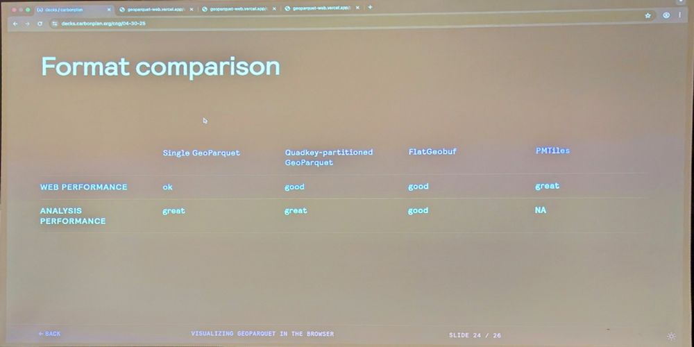
Shane @carbonplan.org Comparing performance between single GeoParquet, quadkey partitioned GeoParquet, FlatGeobuf, and PMTiles #cngconference
April 30, 2025 at 7:36 PM
Shane @carbonplan.org Comparing performance between single GeoParquet, quadkey partitioned GeoParquet, FlatGeobuf, and PMTiles #cngconference
Awesome, thankyou! Geoparquet is something I've wanted to explore for a while, but it looks like there's not QGIS support yet (not a deal breaker, but would be nice). Have just tested flatgeobuf and it already loads so much faster in QGIS than my previous GeoJSON - looking very promising!
November 20, 2024 at 1:41 AM
Awesome, thankyou! Geoparquet is something I've wanted to explore for a while, but it looks like there's not QGIS support yet (not a deal breaker, but would be nice). Have just tested flatgeobuf and it already loads so much faster in QGIS than my previous GeoJSON - looking very promising!

Wondering why Kyle lumped FlatGeobuf in with GeoJSON, SHP & GPKG. Clearly, he knows the difference.
GeoParquet is a complex dog and requires a stack from hell to retrieve a bbox of data in browser, unlike FGB. FGB and COPC (cloud optimized point cloud) are the only cloud native vector formats.
GeoParquet is a complex dog and requires a stack from hell to retrieve a bbox of data in browser, unlike FGB. FGB and COPC (cloud optimized point cloud) are the only cloud native vector formats.
December 19, 2024 at 9:18 PM
Wondering why Kyle lumped FlatGeobuf in with GeoJSON, SHP & GPKG. Clearly, he knows the difference.
GeoParquet is a complex dog and requires a stack from hell to retrieve a bbox of data in browser, unlike FGB. FGB and COPC (cloud optimized point cloud) are the only cloud native vector formats.
GeoParquet is a complex dog and requires a stack from hell to retrieve a bbox of data in browser, unlike FGB. FGB and COPC (cloud optimized point cloud) are the only cloud native vector formats.

FlatGeobuf - a performant binary encoding for geographic data based on flatbuffers
Geo datastructures is either something you are deep into, or you will find some new data structure or extended implementation every two days... I'm clearly in the latter group.
Geo datastructures is either something you are deep into, or you will find some new data structure or extended implementation every two days... I'm clearly in the latter group.
FlatGeobuf
A performant binary encoding for geographic data based on flatbuffers
flatgeobuf.org
February 17, 2025 at 1:56 PM
FlatGeobuf - a performant binary encoding for geographic data based on flatbuffers
Geo datastructures is either something you are deep into, or you will find some new data structure or extended implementation every two days... I'm clearly in the latter group.
Geo datastructures is either something you are deep into, or you will find some new data structure or extended implementation every two days... I'm clearly in the latter group.

🆕 #CNG2025 session video
Safe Software's Dean Hintz talks about #FME's role in building #cloudnativegeo workflows. This talk covers formats like GeoParquet, FlatGeobuf & real-world case studies like the urban heat risk in NYC for more focused weather alerts
▶️ youtu.be/PE0MSjy7EA8
Safe Software's Dean Hintz talks about #FME's role in building #cloudnativegeo workflows. This talk covers formats like GeoParquet, FlatGeobuf & real-world case studies like the urban heat risk in NYC for more focused weather alerts
▶️ youtu.be/PE0MSjy7EA8

[CNG 2025] FME Workflows to Support Loading & Automation Pipelines for Cloud-Native – Dean Hintz
YouTube video by Cloud-Native Geospatial Forum
youtu.be
September 2, 2025 at 2:30 PM
🆕 #CNG2025 session video
Safe Software's Dean Hintz talks about #FME's role in building #cloudnativegeo workflows. This talk covers formats like GeoParquet, FlatGeobuf & real-world case studies like the urban heat risk in NYC for more focused weather alerts
▶️ youtu.be/PE0MSjy7EA8
Safe Software's Dean Hintz talks about #FME's role in building #cloudnativegeo workflows. This talk covers formats like GeoParquet, FlatGeobuf & real-world case studies like the urban heat risk in NYC for more focused weather alerts
▶️ youtu.be/PE0MSjy7EA8
Depending on intended use flatgeobuf is perhaps a smidge easier to use in a web browser. Geoparquet requires some more complicated dependencies, but I'm probably about 1 year behind in my last muck about with it so things may have improved.
November 20, 2024 at 1:38 AM
Depending on intended use flatgeobuf is perhaps a smidge easier to use in a web browser. Geoparquet requires some more complicated dependencies, but I'm probably about 1 year behind in my last muck about with it so things may have improved.
What if you have 100's MB of data? It's far more efficient using a cloud native vector format like FlatGeoBuf (FGB). This requires no intermediate servers or services, just browser and a FGB file(s) on a simple web server. 330MB example, all California roads:
www.cloudnativemaps.com/examples/roa...
www.cloudnativemaps.com/examples/roa...
January 3, 2025 at 5:45 PM
What if you have 100's MB of data? It's far more efficient using a cloud native vector format like FlatGeoBuf (FGB). This requires no intermediate servers or services, just browser and a FGB file(s) on a simple web server. 330MB example, all California roads:
www.cloudnativemaps.com/examples/roa...
www.cloudnativemaps.com/examples/roa...
For anyone interested in displaying a flatgeobuf file efficiently on a maplibre-gl / mapbox-gl map I've created a little library that helps make tiled requests to your flatgeobuf datasource, this is particularly handy if your datasource is very large.
github.com/rowanwins/ma...
github.com/rowanwins/ma...
Hey #geospatial brains-trust: what cloud-native #GIS data format should I use for my data?
I have a largish point dataset (27 million points, 36 columns) that I want to put on AWS S3 for remote access. Ideally, I'd love users to be able to load data for a small AOI without downloading everything!
I have a largish point dataset (27 million points, 36 columns) that I want to put on AWS S3 for remote access. Ideally, I'd love users to be able to load data for a small AOI without downloading everything!


November 20, 2024 at 2:20 AM
For anyone interested in displaying a flatgeobuf file efficiently on a maplibre-gl / mapbox-gl map I've created a little library that helps make tiled requests to your flatgeobuf datasource, this is particularly handy if your datasource is very large.
github.com/rowanwins/ma...
github.com/rowanwins/ma...

I mean, shapefiles suck almost as much as kmls. And yet, somehow, they are quasi-standards in the agtech industry.
Long live the geopackage! (and flatgeobuf)
Long live the geopackage! (and flatgeobuf)
November 22, 2024 at 11:59 AM
I mean, shapefiles suck almost as much as kmls. And yet, somehow, they are quasi-standards in the agtech industry.
Long live the geopackage! (and flatgeobuf)
Long live the geopackage! (and flatgeobuf)
Geopandas definitely makes it more difficult to read GeoParquet data remotely - FlatGeoBuf "just works" both locally and streaming from the cloud! 🚀
November 20, 2024 at 4:14 AM
Geopandas definitely makes it more difficult to read GeoParquet data remotely - FlatGeoBuf "just works" both locally and streaming from the cloud! 🚀
...and for vector data you have SOZip, Search Optimized Zip, that works with GeoPackage and FlatGeoBuf. You can use the indexes in your spatial data even though the data is compressed!
You get the similar shocking results.
You get the similar shocking results.
April 17, 2025 at 4:36 PM
...and for vector data you have SOZip, Search Optimized Zip, that works with GeoPackage and FlatGeoBuf. You can use the indexes in your spatial data even though the data is compressed!
You get the similar shocking results.
You get the similar shocking results.

November 20, 2024 at 4:56 AM
For some reason I thought QGIS didn't support them, but I just tried dragging one in and it loaded fine (maybe no write support?). That's cool - I think I'll try out both GeoParquet and FlatGeoBuf and see which wins!
November 20, 2024 at 2:50 AM
For some reason I thought QGIS didn't support them, but I just tried dragging one in and it loaded fine (maybe no write support?). That's cool - I think I'll try out both GeoParquet and FlatGeoBuf and see which wins!