


🆕 #CNG2025 session video
Safe Software's Dean Hintz talks about #FME's role in building #cloudnativegeo workflows. This talk covers formats like GeoParquet, FlatGeobuf & real-world case studies like the urban heat risk in NYC for more focused weather alerts
▶️ youtu.be/PE0MSjy7EA8
Safe Software's Dean Hintz talks about #FME's role in building #cloudnativegeo workflows. This talk covers formats like GeoParquet, FlatGeobuf & real-world case studies like the urban heat risk in NYC for more focused weather alerts
▶️ youtu.be/PE0MSjy7EA8

[CNG 2025] FME Workflows to Support Loading & Automation Pipelines for Cloud-Native – Dean Hintz
YouTube video by Cloud-Native Geospatial Forum
youtu.be
September 2, 2025 at 2:30 PM
🆕 #CNG2025 session video
Safe Software's Dean Hintz talks about #FME's role in building #cloudnativegeo workflows. This talk covers formats like GeoParquet, FlatGeobuf & real-world case studies like the urban heat risk in NYC for more focused weather alerts
▶️ youtu.be/PE0MSjy7EA8
Safe Software's Dean Hintz talks about #FME's role in building #cloudnativegeo workflows. This talk covers formats like GeoParquet, FlatGeobuf & real-world case studies like the urban heat risk in NYC for more focused weather alerts
▶️ youtu.be/PE0MSjy7EA8

New GeoArrow-Rust release (& Python bindings) with a dedicated FlatGeobuf reader and writer:
- Fast bounding box queries, pushed down to the original file format
- Sync/async data reading through obstore
- Fully Rust with no GDAL means easy installation
geoarrow.org/geoarrow-rs/...
- Fast bounding box queries, pushed down to the original file format
- Sync/async data reading through obstore
- Fully Rust with no GDAL means easy installation
geoarrow.org/geoarrow-rs/...

FlatGeobuf - geoarrow-rust
Python bindings to Rust implementation of GeoArrow
geoarrow.org
August 8, 2025 at 5:08 PM
New GeoArrow-Rust release (& Python bindings) with a dedicated FlatGeobuf reader and writer:
- Fast bounding box queries, pushed down to the original file format
- Sync/async data reading through obstore
- Fully Rust with no GDAL means easy installation
geoarrow.org/geoarrow-rs/...
- Fast bounding box queries, pushed down to the original file format
- Sync/async data reading through obstore
- Fully Rust with no GDAL means easy installation
geoarrow.org/geoarrow-rs/...

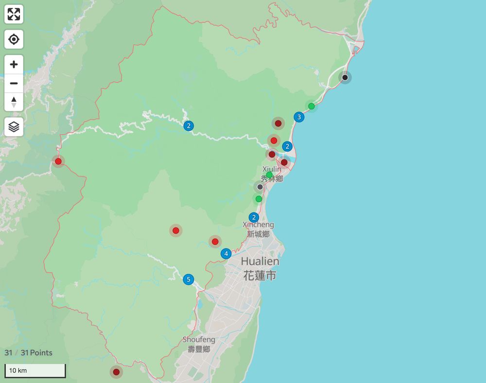
A little weekend mapping project: fetch ~500 administrative boundary data from Overture Maps, convert to FlatGeobuf, and display on my existing MapLibre/Protomaps-based application. No Google Maps involved here!
Incidentally I've found more than a few locations situated in the wrong district...
Incidentally I've found more than a few locations situated in the wrong district...


July 23, 2025 at 4:24 AM
A little weekend mapping project: fetch ~500 administrative boundary data from Overture Maps, convert to FlatGeobuf, and display on my existing MapLibre/Protomaps-based application. No Google Maps involved here!
Incidentally I've found more than a few locations situated in the wrong district...
Incidentally I've found more than a few locations situated in the wrong district...

Interactive viewing of FlatGeobuf files in the web browser, to inspect the files and see the properties of the geometries and metadata of the file #flatgeobuf
do-me.github.io/flatgeobuf-v...
do-me.github.io/flatgeobuf-v...
July 15, 2025 at 12:01 PM
Interactive viewing of FlatGeobuf files in the web browser, to inspect the files and see the properties of the geometries and metadata of the file #flatgeobuf
do-me.github.io/flatgeobuf-v...
do-me.github.io/flatgeobuf-v...

Visualització interactiva d'arxius FlatGeobuf al navegador web, per inspeccionar els arxius i veure les propietats de les geometries i les metadades del fitxer
https://do-me.github.io/flatgeobuf-viewer/
https://do-me.github.io/flatgeobuf-viewer/

July 15, 2025 at 4:28 AM
Visualització interactiva d'arxius FlatGeobuf al navegador web, per inspeccionar els arxius i veure les propietats de les geometries i les metadades del fitxer
https://do-me.github.io/flatgeobuf-viewer/
https://do-me.github.io/flatgeobuf-viewer/

geoimport is a JavaScript library based on gdal3.js.
It allows to convert geospatial data (TopoJSON, Shapefile, Geopackage, GML, KML, GPX, FlatGeobuf, CSV, ODS & XLSX) to and from GeoJSON format. Practical and essential 🥰
code: github.com/riatelab/geo...
demo: observablehq.com/@mthh/hello-...
It allows to convert geospatial data (TopoJSON, Shapefile, Geopackage, GML, KML, GPX, FlatGeobuf, CSV, ODS & XLSX) to and from GeoJSON format. Practical and essential 🥰
code: github.com/riatelab/geo...
demo: observablehq.com/@mthh/hello-...
May 19, 2025 at 10:37 AM
geoimport is a JavaScript library based on gdal3.js.
It allows to convert geospatial data (TopoJSON, Shapefile, Geopackage, GML, KML, GPX, FlatGeobuf, CSV, ODS & XLSX) to and from GeoJSON format. Practical and essential 🥰
code: github.com/riatelab/geo...
demo: observablehq.com/@mthh/hello-...
It allows to convert geospatial data (TopoJSON, Shapefile, Geopackage, GML, KML, GPX, FlatGeobuf, CSV, ODS & XLSX) to and from GeoJSON format. Practical and essential 🥰
code: github.com/riatelab/geo...
demo: observablehq.com/@mthh/hello-...

what's possible on a $5 4 core VPS? A lot actually: full-text search with #sqlite and fts5, lightning fast vector tiles with mbtiles, and decent performance with vector tiles generated on-the-fly via #flatgeobuf #geopackage easily increased with double the cores #gis #gischat
www.getbounds.dev
www.getbounds.dev
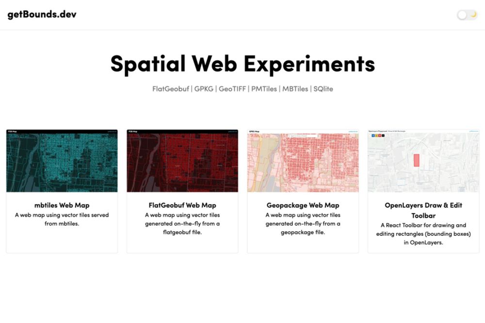
getBounds.dev
Spatial Experiments for the Web
www.getbounds.dev
May 9, 2025 at 3:17 PM
what's possible on a $5 4 core VPS? A lot actually: full-text search with #sqlite and fts5, lightning fast vector tiles with mbtiles, and decent performance with vector tiles generated on-the-fly via #flatgeobuf #geopackage easily increased with double the cores #gis #gischat
www.getbounds.dev
www.getbounds.dev
Flatgeobuf on-demand vector tiling performance on a $5 4-core server *almost* good enough. The FGB process uses http range requests with minimal latency as the data host is the web server not a cloud bucket. More/faster server cores (my m2 Mac) make it much more viable. #gis #gischat #webmaps #cng
May 4, 2025 at 12:27 PM

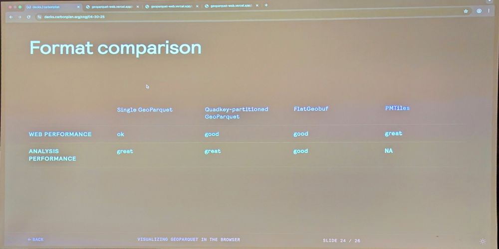
Shane @carbonplan.org Comparing performance between single GeoParquet, quadkey partitioned GeoParquet, FlatGeobuf, and PMTiles #cngconference
April 30, 2025 at 7:36 PM
Shane @carbonplan.org Comparing performance between single GeoParquet, quadkey partitioned GeoParquet, FlatGeobuf, and PMTiles #cngconference

Cloud Native vector format FlatGeoBuf (FGB) can be another approach. The JS works on any FGB, no niche JS required.
Using the same state/county/tract zoom strategy, display National Risk Index data, with Expected Loss colors/legend, too! Click poly for NRI data.
www.femafhz.com/map/27.82240...
Using the same state/county/tract zoom strategy, display National Risk Index data, with Expected Loss colors/legend, too! Click poly for NRI data.
www.femafhz.com/map/27.82240...

April 26, 2025 at 5:47 PM
Cloud Native vector format FlatGeoBuf (FGB) can be another approach. The JS works on any FGB, no niche JS required.
Using the same state/county/tract zoom strategy, display National Risk Index data, with Expected Loss colors/legend, too! Click poly for NRI data.
www.femafhz.com/map/27.82240...
Using the same state/county/tract zoom strategy, display National Risk Index data, with Expected Loss colors/legend, too! Click poly for NRI data.
www.femafhz.com/map/27.82240...
...and for vector data you have SOZip, Search Optimized Zip, that works with GeoPackage and FlatGeoBuf. You can use the indexes in your spatial data even though the data is compressed!
You get the similar shocking results.
You get the similar shocking results.
April 17, 2025 at 4:36 PM
...and for vector data you have SOZip, Search Optimized Zip, that works with GeoPackage and FlatGeoBuf. You can use the indexes in your spatial data even though the data is compressed!
You get the similar shocking results.
You get the similar shocking results.

Danmark har heldigvis meget geodata offentligt tilgængelig. Og så importerede jeg blot førnævnte lag-tjeneste til QGIS (og eksporterede den til en lokal FlatGeobuf-fil). Så tak til QGIS, åbne standarder og åbne data :-)
March 31, 2025 at 7:40 PM
Danmark har heldigvis meget geodata offentligt tilgængelig. Og så importerede jeg blot førnævnte lag-tjeneste til QGIS (og eksporterede den til en lokal FlatGeobuf-fil). Så tak til QGIS, åbne standarder og åbne data :-)

Turns out what I found was the flatgeobuf format. Looks like it has a translator in the OGC package, so I will have to give that a shot for converting small datasets to for use on the web.
Too much new stuff to keep up with! 😊
flatgeobuf.org
Too much new stuff to keep up with! 😊
flatgeobuf.org
FlatGeobuf
A performant binary encoding for geographic data based on flatbuffers
flatgeobuf.org
March 19, 2025 at 3:19 PM
Turns out what I found was the flatgeobuf format. Looks like it has a translator in the OGC package, so I will have to give that a shot for converting small datasets to for use on the web.
Too much new stuff to keep up with! 😊
flatgeobuf.org
Too much new stuff to keep up with! 😊
flatgeobuf.org

FlatGeobuf - a performant binary encoding for geographic data based on flatbuffers
Geo datastructures is either something you are deep into, or you will find some new data structure or extended implementation every two days... I'm clearly in the latter group.
Geo datastructures is either something you are deep into, or you will find some new data structure or extended implementation every two days... I'm clearly in the latter group.
FlatGeobuf
A performant binary encoding for geographic data based on flatbuffers
flatgeobuf.org
February 17, 2025 at 1:56 PM
FlatGeobuf - a performant binary encoding for geographic data based on flatbuffers
Geo datastructures is either something you are deep into, or you will find some new data structure or extended implementation every two days... I'm clearly in the latter group.
Geo datastructures is either something you are deep into, or you will find some new data structure or extended implementation every two days... I'm clearly in the latter group.

GeoArrow/GeoParquet doing for geo data what standard Arrow did for normal time series is awesome. "GDAL’s adoption of GeoArrow made it 23x faster to read FlatGeobuf and GeoPackage into GeoPandas"
Was a pleasure to be interviewed for the @cloudnativegeo.org blog!
cloudnativegeo.org/blog/2024/12...
cloudnativegeo.org/blog/2024/12...
February 1, 2025 at 12:14 AM
GeoArrow/GeoParquet doing for geo data what standard Arrow did for normal time series is awesome. "GDAL’s adoption of GeoArrow made it 23x faster to read FlatGeobuf and GeoPackage into GeoPandas"
So, I scraped your geojson data and recreated your map using Leaflet & cloud native FlatGeobuf, 74 lines of HTML & JavaScript. Note the initial load time. It loads < 1MB of data.
www.delnorteresort.com/ukbus/
www.delnorteresort.com/ukbus/
January 3, 2025 at 8:43 PM
So, I scraped your geojson data and recreated your map using Leaflet & cloud native FlatGeobuf, 74 lines of HTML & JavaScript. Note the initial load time. It loads < 1MB of data.
www.delnorteresort.com/ukbus/
www.delnorteresort.com/ukbus/
What if you have 100's MB of data? It's far more efficient using a cloud native vector format like FlatGeoBuf (FGB). This requires no intermediate servers or services, just browser and a FGB file(s) on a simple web server. 330MB example, all California roads:
www.cloudnativemaps.com/examples/roa...
www.cloudnativemaps.com/examples/roa...
January 3, 2025 at 5:45 PM
What if you have 100's MB of data? It's far more efficient using a cloud native vector format like FlatGeoBuf (FGB). This requires no intermediate servers or services, just browser and a FGB file(s) on a simple web server. 330MB example, all California roads:
www.cloudnativemaps.com/examples/roa...
www.cloudnativemaps.com/examples/roa...
Wondering why Kyle lumped FlatGeobuf in with GeoJSON, SHP & GPKG. Clearly, he knows the difference.
GeoParquet is a complex dog and requires a stack from hell to retrieve a bbox of data in browser, unlike FGB. FGB and COPC (cloud optimized point cloud) are the only cloud native vector formats.
GeoParquet is a complex dog and requires a stack from hell to retrieve a bbox of data in browser, unlike FGB. FGB and COPC (cloud optimized point cloud) are the only cloud native vector formats.
December 19, 2024 at 9:18 PM
Wondering why Kyle lumped FlatGeobuf in with GeoJSON, SHP & GPKG. Clearly, he knows the difference.
GeoParquet is a complex dog and requires a stack from hell to retrieve a bbox of data in browser, unlike FGB. FGB and COPC (cloud optimized point cloud) are the only cloud native vector formats.
GeoParquet is a complex dog and requires a stack from hell to retrieve a bbox of data in browser, unlike FGB. FGB and COPC (cloud optimized point cloud) are the only cloud native vector formats.
Cloud native data. #CloudOptimizedGeotiff for raster and #flatgeobuf for vector. Uses only your browser and data hosted on cheap S3 or simple web server. No API or intermediate server/services. This allows you to do outrageous things:
www.cloudnativemaps.com
#gischat
www.cloudnativemaps.com
#gischat
CloudNativeMaps.com - Visualizing GeoSpatial
Visualizing Unlimited GeoSpatial Data Using Only Your Web Browser/App
www.cloudnativemaps.com
December 18, 2024 at 10:58 PM
Cloud native data. #CloudOptimizedGeotiff for raster and #flatgeobuf for vector. Uses only your browser and data hosted on cheap S3 or simple web server. No API or intermediate server/services. This allows you to do outrageous things:
www.cloudnativemaps.com
#gischat
www.cloudnativemaps.com
#gischat

I mean, shapefiles suck almost as much as kmls. And yet, somehow, they are quasi-standards in the agtech industry.
Long live the geopackage! (and flatgeobuf)
Long live the geopackage! (and flatgeobuf)
November 22, 2024 at 11:59 AM
I mean, shapefiles suck almost as much as kmls. And yet, somehow, they are quasi-standards in the agtech industry.
Long live the geopackage! (and flatgeobuf)
Long live the geopackage! (and flatgeobuf)

As others say, it depends, as always. 🙃
If you expect mostly column-based operations, use a column-based format (e.g. geoparquet). If you expect mostly row-based operations, use a row-based format (e.g. flatgeobuf).
Also, consider various speed, storage, processing requirements/scenarios.
If you expect mostly column-based operations, use a column-based format (e.g. geoparquet). If you expect mostly row-based operations, use a row-based format (e.g. flatgeobuf).
Also, consider various speed, storage, processing requirements/scenarios.
November 20, 2024 at 1:33 PM
As others say, it depends, as always. 🙃
If you expect mostly column-based operations, use a column-based format (e.g. geoparquet). If you expect mostly row-based operations, use a row-based format (e.g. flatgeobuf).
Also, consider various speed, storage, processing requirements/scenarios.
If you expect mostly column-based operations, use a column-based format (e.g. geoparquet). If you expect mostly row-based operations, use a row-based format (e.g. flatgeobuf).
Also, consider various speed, storage, processing requirements/scenarios.

November 20, 2024 at 4:56 AM

🎉 awesome. FWIW there is no perfect solution for this stuff, lots of pros and cons with diff formats, but my general experience is that flatgeobuf is a bit easier to use, esp for non-developers, but hopefully with time geoparquet support will improve & APIs will get simpler.
November 20, 2024 at 4:19 AM
🎉 awesome. FWIW there is no perfect solution for this stuff, lots of pros and cons with diff formats, but my general experience is that flatgeobuf is a bit easier to use, esp for non-developers, but hopefully with time geoparquet support will improve & APIs will get simpler.