EarthScope Consortium
@earthscope.org
3.7K followers 160 following 450 posts
EarthScope Consortium supports transformative global geophysical research and education. Operator of the NSF National Geophysical Facility. #NSFfunded
Posts Media Videos Starter Packs
Reposted by EarthScope Consortium
stevenjgibbons.bsky.social
Magnitude 7.6 Strike-slip #earthquake in the Drake Passage (between Patagonia and Antarctica) about 40 minutes ago (2025-10-10Z20:29) Signal here on station GT.PLCA (Paso Flores, Argentina) earthquake.usgs.gov/earthquakes/...
Signal on a seismic station from the 7.6 earthquake 2025-10-10 in the Drake Passage
earthscope.org
A M7.4 earthquake struck off the southern Philippines on October 10. Where the Philippine Sea Plate dives beneath the Sunda Plate, complex subduction on both sides of the Philippines archipelago makes the region highly seismically active.

Explore more & access event data: https://loom.ly/GHCi3lg
earthscope.org
EarthScope is looking for a GeoWorkforce Associate (remote, US) to help lead internship programs and other products that facilitate the development of a robust, well-trained geoscience workforce.

Learn more & apply: https://earthscope.org/careers/
Students and an instructor kneel on the grass connecting cables as part of a seismic experiment. Text reads "We're Hiring!" with a link to earthscope.org/careers. The graphic is overlain by a purple to red gradient.
earthscope.org
EarthScope is hiring a Full-Stack Web Designer/Developer (remote, US) to lead the end-to-end design and development of a website for the NSF-funded National Geophysical Facility, as well as the evolution of EarthScope’s existing web stack.

Learn more & apply: https://earthscope.org/careers/
Overhead view of a web developer with multiple printed design documents, laptop and monitor screens, overlain by a red to purple gradient. Text reads "We're Hiring!" with a link to earthscope.org/careers
Reposted by EarthScope Consortium
acarrerac.bsky.social
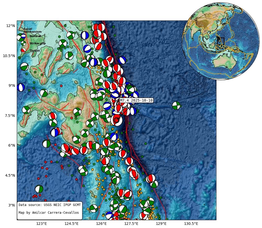
M7.4 just struck the coast of the #Philippines at a depth of 58.1km according to the USGS.
The #earthquake shown occurred on the western margin of the Philippine Trench, where the Philippine oceanic plate begins its subduction beneath the Mindanao microplate.
The information box highlights the main event.
Reposted by EarthScope Consortium
earthjay.bsky.social
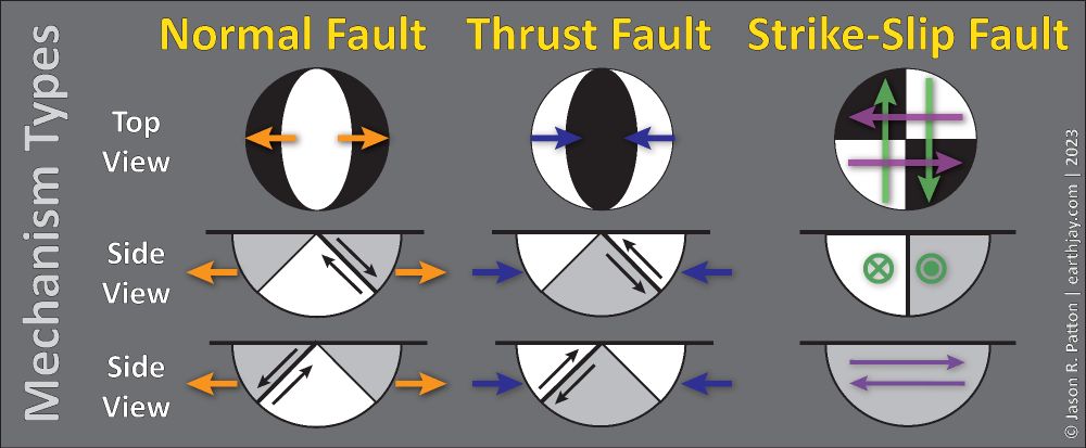
#EarthquakeReport for M7.4 #Earthquake #Lindol offshore of the #Philippines

Reverse (Compressional) earthquake mechanism
Probably on megathrust subduction zone fault
Possible local #Tsunami

Tectonic background in 2023 report earthjay.com?p=11611

earthquake.usgs.gov/earthquakes/...
earthscope.org
International #ShakeOut Day is one week away! On Thursday, October 16 at 10:16 am (local time), join millions of people around the world practicing earthquake safety. Register and learn more at shakeout.org.

Be prepared and practice your Drop, Cover, and Hold On!
earthscope.org
This simple model illustrates how resonance can sometimes cause buildings of certain heights to see the most damage during an earthquake.

Classroom resources ➡️ https://loom.ly/w0ghACs
earthscope.org
Magnetotellurics (MT) measure the conductivity (or resistivity) of the Earth. Earth’s magnetic field induces electric currents in the Earth. The strength of this induced signal depends on the conductivity of the materials below the surface.

Learn more about MT ⬇️
https://loom.ly/QoServY
Current map of the United States Geoelectric Field Model, with brighter blue colors along the eastern seaborn and darker blue colors along the West Coast
earthscope.org
WEBINAR RECORDING

Ionospheric anomaly detection and source geolocation over open ocean with GNSS remote sensing

Presented by Fiona Luhrmann (Oregon State University)

📽️ https://youtu.be/4EkmnfesIDM
Video thumbnail depicted schematic of GNSS satellites measuring ionospheric disturbances caused by an earthquake
earthscope.org
EarthScope is excited to be undertaking operations of the NSF National Geophysical Facility, as of October 1. Curious what this means in terms of geophysical research and education support? Check out these helpful FAQs.
⬇️
https://ngf.earthscope.org/
Graphic with text "Powering geophysics, empowering a resilient society" with the NSF and National Geophysical Facility logos over a red to purple landscape gradient
earthscope.org
EarthScope is hiring a Global Networks Program Manager (remote, US) to lead facility scope of the Global Seismographic Network and NASA Global GNSS Network, both crucial tools for worldwide geophysical monitoring.

Learn more & apply ➡️ https://www.earthscope.org/careers/
Promotional graphic with text 'We’re Hiring!' and 'earthscope.org/careers.' The background shows a geodetic GNSS antenna in the foreground and a large radio telescope in the distance.
earthscope.org
Don't forget to register and join us for our first EarthScope Webinar of the fall tomorrow!

earthscope-org.zoom.us/webinar/regi...
earthscope.org
EarthScope Webinars have returned! Please join for our upcoming Webinar on Thursday, October 2 at 12 pm MT.

Ionospheric anomaly detection and source geolocation over open ocean with GNSS remote sensing

Presenter: Fiona Luhrmann (Oregon State University)

Register ➡️ https://loom.ly/nsdgPbU
Graphic advertising upcoming webinar on October 2
Reposted by EarthScope Consortium
diegosismologo.bsky.social
On July 29, 2025 a Mw 8.8 earthquake off Kamchatka launched a Pacific-wide tsunami, right as the SWOT satellite flew south-to-north taking altimetry measurements of the wave train. In our new preprint, we pair SWOT with nearby DART buoys to capture the tsunami’s propagation and its source
Reposted by EarthScope Consortium
jascha.bsky.social
M6.9 #earthquake in the Philippines: shallow strike slip faulting with yellow PAGER alert for shaking related fatalities and economic losses.⚒️
Historic seismicity map of Philippines generated using GMT software by Jascha Polet
earthscope.org
As the NSF GAGE and SAGE facilities come to a close, we thank the NSF for its sustained investment and our community for advancing geophysical research and education. EarthScope is honored to serve as operator of the new NSF National Geophysical Facility, ushering in the next era of geophysics.
Infographic titled "Celebrating the Impact of NSF’s GAGE and SAGE Facilities (2018–2025)." Lists: 551 experiments, 31,942 unique datasets, 12,643 peer-reviewed publications, 14,001 unique authors, and 448,729 citations. Each statistic is paired with a simple icon. Background shows a shaded relief map with a red-to-purple gradient border at top and bottom.
earthscope.org
Each arrow on this map is a GPS velocity vector showing how the ground is moving relative to interior eastern North America. The arrow’s length tells us the speed (longer means faster), and its direction shows where the ground is moving, revealing how tectonic forces are shaping the western US.
Map of the western U.S. with arrows showing GPS stations’ ground motion—arrow length is speed, direction shows movement.
earthscope.org
Each summer, EarthScope welcomes a new cohort of students into immersive internships. Summer 2025 marked one of the largest cohorts yet, with 33 interns placed at universities, research institutions, and national laboratories across the United States.

Read more ⬇️
https://loom.ly/W8I8nT0
Group photo of 2025 summer interns. Students are in three rows, some kneel on the ground in front, and then students stand in two rows. The photo is outdoors on a campus area.
earthscope.org
EarthScope Webinars have returned! Please join for our upcoming Webinar on Thursday, October 2 at 12 pm MT.

Ionospheric anomaly detection and source geolocation over open ocean with GNSS remote sensing

Presenter: Fiona Luhrmann (Oregon State University)

Register ➡️ https://loom.ly/nsdgPbU
Graphic advertising upcoming webinar on October 2
earthscope.org
A simple tabletop "earthquake machine" can illustrate the seismic cycle — and help us see why earthquakes are cyclical, but not predictable.
earthscope.org
The NSF GAGE Facility helps monitor permanent GNSS stations that comprise the NASA Global GNSS Network (GGN). Data from these stations are used to produce highly accurate products that are essential for Earth science research, multidisciplinary applications, and education.

https://loom.ly/aZPV4w0
Split image with a GNSS antenna on a tropical island with the ocean in the background next to a world map showing station locations in the NASA GGN.