James Peacock
@peacockreports.bsky.social
440 followers 58 following 1.7K posts
Head Meteorologist at MetSwift, working to revolutionise delivery of weather information. LinkedIn: https://t.co/pUCAQfAfRP
Posts Media Videos Starter Packs
peacockreports.bsky.social
How slow-moving remains to be seen, with GFS bringing a more progressive westerly regime than ECMWF, hence the difference in distribution of highest amounts.
peacockreports.bsky.social
GFS & ECMWF's latest det. runs agree on little to no rainfall across the UK & most or all of Ireland through to the end of Saturday... before a dramatic change of theme starting Sunday or Monday.

Some fairly slow-moving lows off the Atlantic bring lengthy spells of rain.
peacockreports.bsky.social
More specifically, during a La Niña, there's a signal for colder than usual (1991-2020 average) temps that begins in eastern Europe for an active MJO in phase 5, then extends to western Europe for phase 6.

It's not a guaranteed response, just one that occurs more often than not.
peacockreports.bsky.social
...which will have a big bearing on November's weather patterns in the North Atlantic & Europe.

*If* the MJO remains active (i.e. black line on graph outside the centre circle) through phases 5-7, anomalously cold patterns would be favoured with respect to much of Europe.
peacockreports.bsky.social
...which has only just started to unfold as of now, meaning most of what the seasonal models learned from featured a 'possible MJO event' rather than confirmed one.

Not only that, but it remains to be resolved how the MJO behaves going forward...
peacockreports.bsky.social
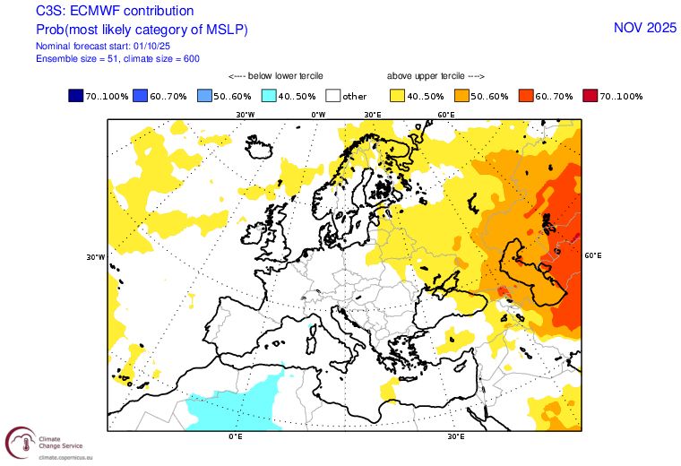
Even the individual model ensemble sets offer only weak weather pattern signals for November (or December).

I suspect this has to do with a recently emerged signal for an event in the tropics known as the Madden-Julian Oscillation to initiate later this month...
peacockreports.bsky.social
As a result, the mean temperature anomaly predictions are dominated by long-term trends & recent sea temperature anomalies, while the mean wind speed anomalies are extremely vague.

Evidently, there's a lot to be sorted out.
peacockreports.bsky.social
The multi-model blended seasonal guidance for sea-level pressure anomalies across Europe during the final two months of 2025 offers only a subtle hint for November, & nothing at all for December.

It's a similar story for precipitation anomalies. Little cross-model consensus.
peacockreports.bsky.social
In fact, the path similarity looks uncanny, with Lorenzo 2025 recurving just a little more sharply than Lorenzo 2019.

en.wikipedia.org/wiki/Hurrica...
peacockreports.bsky.social
By some coincidence, the previous incarnation of Lorenzo in the Atlantic basin (2019) was also in the central area.

But that one peaked as a category 5, the furthest east on record in the basin, while this year's isn't currently forecast to get beyond tropical storm strength.
peacockreports.bsky.social
Tropical storm Lorenzo was designated by the NHC at 9:00 UTC today, the 12th named storm of the season, which means 2025 is well ahead of the 1981-2020 median date for the first time since late August.

It's still well off pace for a top 10% season, however.
peacockreports.bsky.social
Phone cam fails to do the justice, to the naked eye it’s an oddly vivid shade of pink, never seen a sunset like it here before.
peacockreports.bsky.social
Also witnessed an… ash devil?
peacockreports.bsky.social
Today’s walk theme: New life after the inferno.

At Holt Heath, where a wildfire raged last August.
peacockreports.bsky.social
For 1st March to 9th October, 2025 is the driest on record, 8.9 mm below the 2nd driest (1990).

2025 has delivered 192.9 mm, which is just 49.7% of the average.

These to-date totals will be interesting to review in a week's time, as no measurable rainfall is forecast.
peacockreports.bsky.social
In early October, 2022 became the driest-to-date on record in my local area.

For up to 9th October, 2025 has 89.2 mm more, but is only 22.2 mm above the 5th driest on record.

For rainfall since 1st February, 2025 is 2nd driest & only 9.9 mm above the driest (1959).
peacockreports.bsky.social
This takes the 2025 season to 11 named storms just ahead of the 1981-2020 median date.

Of the past full seasons with at least 18 named storms (i.e. in top 10%), none in the IBTrACS v4 database were on fewer than 12 at this stage.
peacockreports.bsky.social
The forecast map for Karen is a novelty: A brief existence playing out fully to the north of the Azores.
peacockreports.bsky.social
Occasionally, convection at the centre of a broad low manages to disconnect from weather fronts & become a subtropical or tropical cyclone over the mid-latitude North Atlantic.

Such was the case last night, resulting in the designation of subtropical storm Karen by the NHC.
peacockreports.bsky.social
Confidence then decreases steadily when looking through next weekend, with signs that Atlantic westerlies may try to 'overrun' the high (force it to head back south-eastward), bringing wetter, windier weather to NW Europe, but with no consensus on how quickly that occurs.
peacockreports.bsky.social
These omega formations have a habit of retrograding eventually, i.e. the high heads to the west or northwest instead of east or northeast.

Forecast models agree on that happening later next week, but disagree on the finer details of high position & shape.
peacockreports.bsky.social
Over the next five days the high will remain similarly positioned, drifting just a little northward, while lows dig down to its west & east, establishing an 'omega' formation that tends to be difficult to shift.

NW Europe temps on the warm side by day (for mid-Oct), cool nights.
peacockreports.bsky.social
There's a strong high over NW Europe today.

In south-western UK, sea-level pressure is now widely reading 1034 mb (interestingly a tad higher than last night's GFS run predicted), which is the highest reading in that area since the first two days of March (peaked near 1037 mb).
peacockreports.bsky.social
The latest two deterministic GFS runs have had little to no rainfall for southern UK & most of France during the next 15 days.

Not saying this will be the outcome, but it's quite a sight given the time of year.

A key time looks to be later next week when it might turn more unsettled instead.
peacockreports.bsky.social
Checking in on the Pacific typhoon season (West Pacific basin - northern hemisphere).

For the typhoon count, 2025 took longer to get going than many recent years, but has been at the races since mid-September & is now 4 ahead of the 1981-2020 median.