


Taiwan Maps and Dataviz
@alexkunztaipei.com
🗺️ Exploring Taiwan through maps and data visualizations.
✨ Need a custom map or data visual? I can help!
⬇️ Link below for more info.
https://linktr.ee/taiwandataviz
✨ Need a custom map or data visual? I can help!
⬇️ Link below for more info.
https://linktr.ee/taiwandataviz
PLA Air Force activity around Taiwan in December 2025.
Without the late-December “Justice Mission 2025” exercise, activity would have remained relatively low. The exercise itself, however, pushed December to one of the months with the highest sortie counts in 2025.
Without the late-December “Justice Mission 2025” exercise, activity would have remained relatively low. The exercise itself, however, pushed December to one of the months with the highest sortie counts in 2025.

January 2, 2026 at 1:35 AM
PLA Air Force activity around Taiwan in December 2025.
Without the late-December “Justice Mission 2025” exercise, activity would have remained relatively low. The exercise itself, however, pushed December to one of the months with the highest sortie counts in 2025.
Without the late-December “Justice Mission 2025” exercise, activity would have remained relatively low. The exercise itself, however, pushed December to one of the months with the highest sortie counts in 2025.
Happy New Year 2026.
Wishing everyone a peaceful and prosperous year ahead.
This year I chose a retro approach for the image. A few days ago, I came across some pixel art on social media, which gave me the idea to create something similar myself, with the help of AI.
Wishing everyone a peaceful and prosperous year ahead.
This year I chose a retro approach for the image. A few days ago, I came across some pixel art on social media, which gave me the idea to create something similar myself, with the help of AI.

December 31, 2025 at 10:05 AM
Happy New Year 2026.
Wishing everyone a peaceful and prosperous year ahead.
This year I chose a retro approach for the image. A few days ago, I came across some pixel art on social media, which gave me the idea to create something similar myself, with the help of AI.
Wishing everyone a peaceful and prosperous year ahead.
This year I chose a retro approach for the image. A few days ago, I came across some pixel art on social media, which gave me the idea to create something similar myself, with the help of AI.
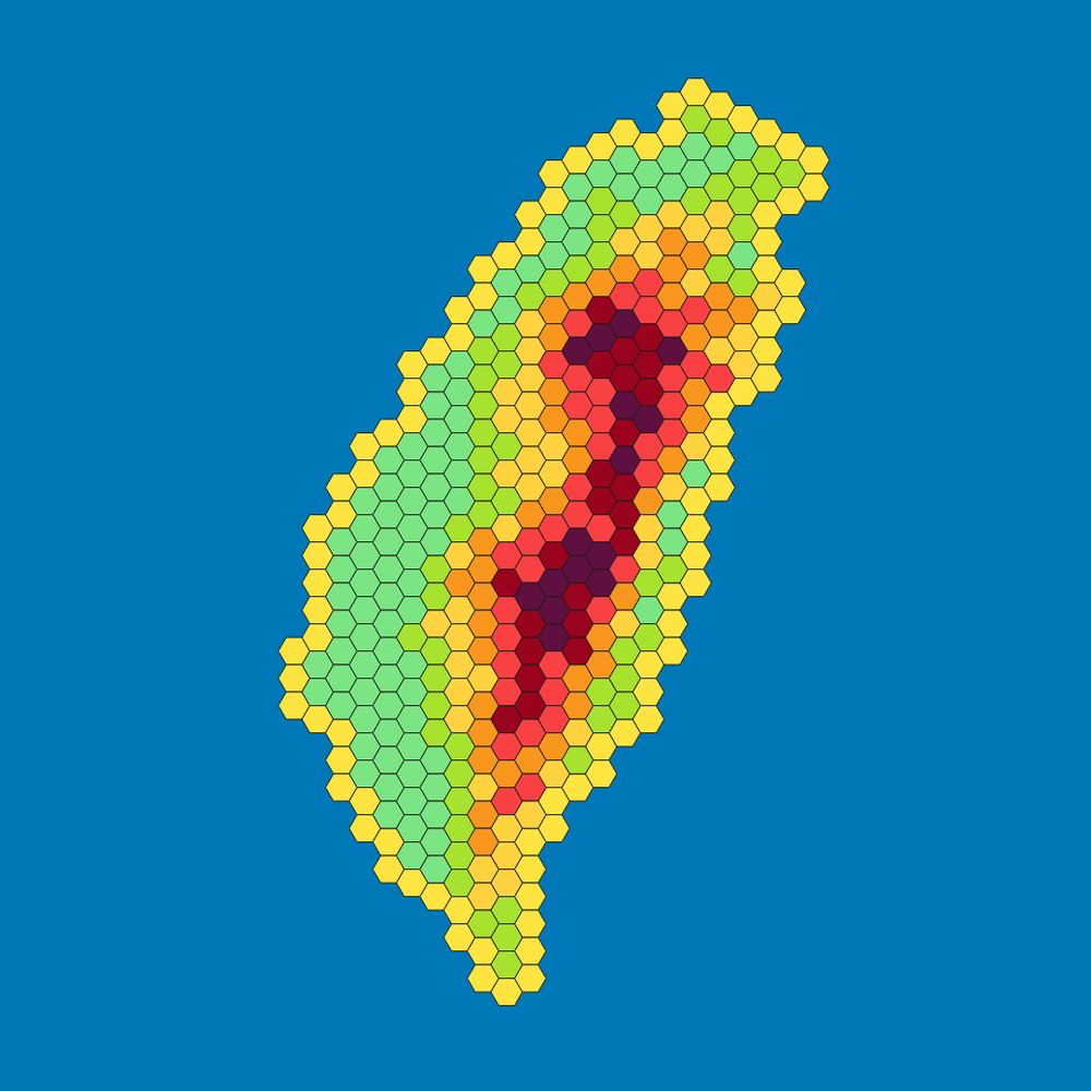
Taiwan’s population density simply divide into three major categories.

December 31, 2025 at 1:11 AM
Taiwan’s population density simply divide into three major categories.
New Year’s Eve is coming up.
This map shows good locations to watch the Taipei 101 fireworks, including spots that also work well for photography and video.
This map shows good locations to watch the Taipei 101 fireworks, including spots that also work well for photography and video.

December 29, 2025 at 12:50 AM
New Year’s Eve is coming up.
This map shows good locations to watch the Taipei 101 fireworks, including spots that also work well for photography and video.
This map shows good locations to watch the Taipei 101 fireworks, including spots that also work well for photography and video.
Taiwan’s road network is longer than the Earth’s circumference at the equator.
With around 42,000 km of roads, Taiwan ranks 73rd worldwide. The network is so dense that it effectively redraws the island itself.
With around 42,000 km of roads, Taiwan ranks 73rd worldwide. The network is so dense that it effectively redraws the island itself.

December 26, 2025 at 1:34 AM
Taiwan’s road network is longer than the Earth’s circumference at the equator.
With around 42,000 km of roads, Taiwan ranks 73rd worldwide. The network is so dense that it effectively redraws the island itself.
With around 42,000 km of roads, Taiwan ranks 73rd worldwide. The network is so dense that it effectively redraws the island itself.
Merry Christmas and a Happy New Year.
Thank you to all followers and supporters. Your likes, shares, and comments have played a key role in growing this account and making these maps and data visualizations visible to more people. Thank you for being part of it.
Thank you to all followers and supporters. Your likes, shares, and comments have played a key role in growing this account and making these maps and data visualizations visible to more people. Thank you for being part of it.

December 24, 2025 at 12:35 AM
Merry Christmas and a Happy New Year.
Thank you to all followers and supporters. Your likes, shares, and comments have played a key role in growing this account and making these maps and data visualizations visible to more people. Thank you for being part of it.
Thank you to all followers and supporters. Your likes, shares, and comments have played a key role in growing this account and making these maps and data visualizations visible to more people. Thank you for being part of it.
Taiwan is home to four major language groups.
This map shows which language is most commonly used in everyday conversations in each district, reflecting dominant use, not exclusivity.
This map shows which language is most commonly used in everyday conversations in each district, reflecting dominant use, not exclusivity.

December 22, 2025 at 12:56 AM
Taiwan is home to four major language groups.
This map shows which language is most commonly used in everyday conversations in each district, reflecting dominant use, not exclusivity.
This map shows which language is most commonly used in everyday conversations in each district, reflecting dominant use, not exclusivity.
How far can really see from the top of Taipei 101?
On a clear day, visibility can reach up to 65 km. Most directions are blocked by mountains, but there are a few spots where you can see the mouth of the Danshui River, almost as far as Keelung, and parts of Taoyuan.
On a clear day, visibility can reach up to 65 km. Most directions are blocked by mountains, but there are a few spots where you can see the mouth of the Danshui River, almost as far as Keelung, and parts of Taoyuan.

December 19, 2025 at 12:38 AM
How far can really see from the top of Taipei 101?
On a clear day, visibility can reach up to 65 km. Most directions are blocked by mountains, but there are a few spots where you can see the mouth of the Danshui River, almost as far as Keelung, and parts of Taoyuan.
On a clear day, visibility can reach up to 65 km. Most directions are blocked by mountains, but there are a few spots where you can see the mouth of the Danshui River, almost as far as Keelung, and parts of Taoyuan.
1899 map with Qing-era place names, even though Taiwan was already under Japanese rule.
Taichung is missing. Instead, the map shows Taiwan-fu, a reminder of the brief plan to make central Taiwan the capital before Taipei took that role.
This map was kindly sent in by a follower.
Taichung is missing. Instead, the map shows Taiwan-fu, a reminder of the brief plan to make central Taiwan the capital before Taipei took that role.
This map was kindly sent in by a follower.

December 17, 2025 at 12:40 AM
1899 map with Qing-era place names, even though Taiwan was already under Japanese rule.
Taichung is missing. Instead, the map shows Taiwan-fu, a reminder of the brief plan to make central Taiwan the capital before Taipei took that role.
This map was kindly sent in by a follower.
Taichung is missing. Instead, the map shows Taiwan-fu, a reminder of the brief plan to make central Taiwan the capital before Taipei took that role.
This map was kindly sent in by a follower.
A series of historic maps of Taiwan from different periods and perspectives.
The map from 1958 comes from an East German (GDR) atlas that labels Taiwan as a Chinese province. The map from 1964, also from an East German publication, goes further by describing Taiwan as occupied by the USA.
The map from 1958 comes from an East German (GDR) atlas that labels Taiwan as a Chinese province. The map from 1964, also from an East German publication, goes further by describing Taiwan as occupied by the USA.


December 15, 2025 at 12:54 AM
A series of historic maps of Taiwan from different periods and perspectives.
The map from 1958 comes from an East German (GDR) atlas that labels Taiwan as a Chinese province. The map from 1964, also from an East German publication, goes further by describing Taiwan as occupied by the USA.
The map from 1958 comes from an East German (GDR) atlas that labels Taiwan as a Chinese province. The map from 1964, also from an East German publication, goes further by describing Taiwan as occupied by the USA.
Taiwan has 14.6 million registered motorcycles, yet the north south distribution is far from equal. The south has significantly more motorcycles per 100 people. But why? Climate? Transport options? Economy? Lifestyle?
What’s your take on this?
What’s your take on this?

December 10, 2025 at 1:59 AM
Taiwan has 14.6 million registered motorcycles, yet the north south distribution is far from equal. The south has significantly more motorcycles per 100 people. But why? Climate? Transport options? Economy? Lifestyle?
What’s your take on this?
What’s your take on this?
Japan plans to deploy surface-to-air missiles on Yonaguni. This map highlights how close the island is to Taiwan. On clear days, Taiwan’s east coast is even visible from Yonaguni.

December 8, 2025 at 12:34 AM
Japan plans to deploy surface-to-air missiles on Yonaguni. This map highlights how close the island is to Taiwan. On clear days, Taiwan’s east coast is even visible from Yonaguni.
Looking for the best places to capture the Taipei 101 fireworks? 🎆
My new map highlights the top spots—mostly on the east side where smoke is minimal.
Arrive early, expect crowds, and think ahead about how to get home.
No secret empty spots—unless you own a rooftop. 😉
My new map highlights the top spots—mostly on the east side where smoke is minimal.
Arrive early, expect crowds, and think ahead about how to get home.
No secret empty spots—unless you own a rooftop. 😉
December 7, 2025 at 1:11 AM
Looking for the best places to capture the Taipei 101 fireworks? 🎆
My new map highlights the top spots—mostly on the east side where smoke is minimal.
Arrive early, expect crowds, and think ahead about how to get home.
No secret empty spots—unless you own a rooftop. 😉
My new map highlights the top spots—mostly on the east side where smoke is minimal.
Arrive early, expect crowds, and think ahead about how to get home.
No secret empty spots—unless you own a rooftop. 😉
German-made cars have a strong reputation in Taiwan.
Here are the most popular German brands, based on registered vehicles.
Interesting surprise: Opel made the list.
Didn’t expect they ever had a foothold here.
What’s your take? Which German brands feel the most visible in Taiwan?
Here are the most popular German brands, based on registered vehicles.
Interesting surprise: Opel made the list.
Didn’t expect they ever had a foothold here.
What’s your take? Which German brands feel the most visible in Taiwan?

December 5, 2025 at 1:01 AM
German-made cars have a strong reputation in Taiwan.
Here are the most popular German brands, based on registered vehicles.
Interesting surprise: Opel made the list.
Didn’t expect they ever had a foothold here.
What’s your take? Which German brands feel the most visible in Taiwan?
Here are the most popular German brands, based on registered vehicles.
Interesting surprise: Opel made the list.
Didn’t expect they ever had a foothold here.
What’s your take? Which German brands feel the most visible in Taiwan?
PLA Air Force activity around Taiwan in November 2025.
“All aircraft” includes fighters, bombers, UAVs, and support types.
Data: Taiwan’s Ministry of National Defense (possible gaps in published figures).
“All aircraft” includes fighters, bombers, UAVs, and support types.
Data: Taiwan’s Ministry of National Defense (possible gaps in published figures).

December 3, 2025 at 12:44 AM
PLA Air Force activity around Taiwan in November 2025.
“All aircraft” includes fighters, bombers, UAVs, and support types.
Data: Taiwan’s Ministry of National Defense (possible gaps in published figures).
“All aircraft” includes fighters, bombers, UAVs, and support types.
Data: Taiwan’s Ministry of National Defense (possible gaps in published figures).
Taiwan has around 14 million motorcycles or motorbikes, mainly scooters. While this number is not exceptionally high in absolute terms, Taiwan ranks at the top globally when adjusted for population — with about 60 motorbikes per 100 people.

December 1, 2025 at 12:29 AM
Taiwan has around 14 million motorcycles or motorbikes, mainly scooters. While this number is not exceptionally high in absolute terms, Taiwan ranks at the top globally when adjusted for population — with about 60 motorbikes per 100 people.
From January to August 2025 most tourists came from Japan, Hong Kong and Macao to Taiwan. Generally visitors from East and South East Asia are dominating.

November 26, 2025 at 1:20 AM
From January to August 2025 most tourists came from Japan, Hong Kong and Macao to Taiwan. Generally visitors from East and South East Asia are dominating.
Proportion of foreign residents across Taiwan. Highest number of foreign residents are in Hsinchu County and Taoyuan City. Compared to last year the number of foreign residents has increased in Taiwan.

November 19, 2025 at 12:29 AM
Proportion of foreign residents across Taiwan. Highest number of foreign residents are in Hsinchu County and Taoyuan City. Compared to last year the number of foreign residents has increased in Taiwan.
Number of foreign residents with legal residence permits (ARC, APRC, Gold Card) in Taiwan. September 2025.
Data from National Immigration Agency Taiwan.
See further comments for number of residents from PRC, HK, Macao in Taiwan.
Data from National Immigration Agency Taiwan.
See further comments for number of residents from PRC, HK, Macao in Taiwan.

November 18, 2025 at 4:26 AM
Number of foreign residents with legal residence permits (ARC, APRC, Gold Card) in Taiwan. September 2025.
Data from National Immigration Agency Taiwan.
See further comments for number of residents from PRC, HK, Macao in Taiwan.
Data from National Immigration Agency Taiwan.
See further comments for number of residents from PRC, HK, Macao in Taiwan.
All typhoon tracks around Taiwan from 1950-2025
November 10, 2025 at 2:55 AM
All typhoon tracks around Taiwan from 1950-2025
Predictions say typhoon Fung-Wong might make landfall on the west coast of Taiwan, which is a rare event. Throughout the last 75 years the majority of typhoons made landfall on the east coast of Taiwan.


November 9, 2025 at 12:20 PM
Predictions say typhoon Fung-Wong might make landfall on the west coast of Taiwan, which is a rare event. Throughout the last 75 years the majority of typhoons made landfall on the east coast of Taiwan.
Here is your Friday Fun Fact about Taiwan:
Taiwan would fit almost entirely into Lake Michigan
(Due to the map projection, Taiwan appears stretched.)
Taiwan would fit almost entirely into Lake Michigan
(Due to the map projection, Taiwan appears stretched.)

November 7, 2025 at 12:51 AM
Here is your Friday Fun Fact about Taiwan:
Taiwan would fit almost entirely into Lake Michigan
(Due to the map projection, Taiwan appears stretched.)
Taiwan would fit almost entirely into Lake Michigan
(Due to the map projection, Taiwan appears stretched.)
Bluesky Challenge: if I reach 100 followers until the end of 2025, I will keep posting here. If not, I will stop posting and you have to follow me where the party is (Threads or Instagram or LinkedIn).
November 6, 2025 at 2:20 PM
Bluesky Challenge: if I reach 100 followers until the end of 2025, I will keep posting here. If not, I will stop posting and you have to follow me where the party is (Threads or Instagram or LinkedIn).
The road network in Taiwan highlights the topography of the island very well.

November 5, 2025 at 1:06 AM
The road network in Taiwan highlights the topography of the island very well.
Roads and trails on Kinmen Islands. Nothing else is shown in this map.

November 4, 2025 at 1:15 AM
Roads and trails on Kinmen Islands. Nothing else is shown in this map.