


Big Earth Data
@bigearthdata1.bsky.social
Big Earth Data is the world's first big data journal in the Earth sciences.
https://www.tandfonline.com/journals/tbed20
https://www.tandfonline.com/journals/tbed20
Reposted by Big Earth Data

New paper | A digital twin approach for the identification and update of ecological infrastructure
This technical note presents a reproducible and automated approach for supporting land management and planning by identifying and updating ecological infrastructure
doi.org/10.1080/2096...
This technical note presents a reproducible and automated approach for supporting land management and planning by identifying and updating ecological infrastructure
doi.org/10.1080/2096...

A digital twin approach for the identification and update of ecological infrastructure
Addressing the global environmental crisis necessitates coordinated efforts, supported by open and reproducible research practices. Such practices aim to enhance the reliability, efficiency, and cr...
doi.org
January 22, 2026 at 9:25 AM
New paper | A digital twin approach for the identification and update of ecological infrastructure
This technical note presents a reproducible and automated approach for supporting land management and planning by identifying and updating ecological infrastructure
doi.org/10.1080/2096...
This technical note presents a reproducible and automated approach for supporting land management and planning by identifying and updating ecological infrastructure
doi.org/10.1080/2096...
📢 Deriving peri-urban settlement typologies from Landsat time series analysis: the case study of #Mankweng and environs (South Africa)
👉 doi.org/10.1080/2096...
#satellite #periurban #settlement #SouthAfrica #Landsat #landuse #landcover #SDGs #remotesensing #GIS #cartography #geovisualisation
👉 doi.org/10.1080/2096...
#satellite #periurban #settlement #SouthAfrica #Landsat #landuse #landcover #SDGs #remotesensing #GIS #cartography #geovisualisation


January 21, 2026 at 9:34 AM
📢 Deriving peri-urban settlement typologies from Landsat time series analysis: the case study of #Mankweng and environs (South Africa)
👉 doi.org/10.1080/2096...
#satellite #periurban #settlement #SouthAfrica #Landsat #landuse #landcover #SDGs #remotesensing #GIS #cartography #geovisualisation
👉 doi.org/10.1080/2096...
#satellite #periurban #settlement #SouthAfrica #Landsat #landuse #landcover #SDGs #remotesensing #GIS #cartography #geovisualisation
📢 A transformer-based multi-feature fusion method for detecting traffic events using Twitter data
👉 doi.org/10.1080/2096...
💌 #traffic #urban #Twitter #remotesensing #GIS #dataanalysis #BigData #deeplearning #urbanmobility #transportation #humanmobility #smartcity #digitaltwin #GeoAI
👉 doi.org/10.1080/2096...
💌 #traffic #urban #Twitter #remotesensing #GIS #dataanalysis #BigData #deeplearning #urbanmobility #transportation #humanmobility #smartcity #digitaltwin #GeoAI


January 12, 2026 at 8:36 AM
📢 A transformer-based multi-feature fusion method for detecting traffic events using Twitter data
👉 doi.org/10.1080/2096...
💌 #traffic #urban #Twitter #remotesensing #GIS #dataanalysis #BigData #deeplearning #urbanmobility #transportation #humanmobility #smartcity #digitaltwin #GeoAI
👉 doi.org/10.1080/2096...
💌 #traffic #urban #Twitter #remotesensing #GIS #dataanalysis #BigData #deeplearning #urbanmobility #transportation #humanmobility #smartcity #digitaltwin #GeoAI
📢Artificial intelligence-driven #precipitation #downscaling and projections over #Thailand using #CMIP6 climate models
👉https://doi.org/10.1080/20964471.2025.2547500
💌 #AI #DyNN-Mem #LSTM #CNN #Deeplearning #machinelearning #CMIP6 #hydrology #climatechange #remotesensing #WaterResources
👉https://doi.org/10.1080/20964471.2025.2547500
💌 #AI #DyNN-Mem #LSTM #CNN #Deeplearning #machinelearning #CMIP6 #hydrology #climatechange #remotesensing #WaterResources


January 6, 2026 at 9:08 AM
📢Artificial intelligence-driven #precipitation #downscaling and projections over #Thailand using #CMIP6 climate models
👉https://doi.org/10.1080/20964471.2025.2547500
💌 #AI #DyNN-Mem #LSTM #CNN #Deeplearning #machinelearning #CMIP6 #hydrology #climatechange #remotesensing #WaterResources
👉https://doi.org/10.1080/20964471.2025.2547500
💌 #AI #DyNN-Mem #LSTM #CNN #Deeplearning #machinelearning #CMIP6 #hydrology #climatechange #remotesensing #WaterResources
💞 🎄 💞 🎄💞This holiday season, we send our heartfelt thanks to our amazing editors, authors, reviewers, and readers. We’re so excited to keep collaborating with you in 2026! Wishing you a warm, joyful Christmas and a New Year full of peace, happiness, and wonderful new opportunities.🌸 🍀 🌸🍀 🌸

December 23, 2025 at 2:15 AM
💞 🎄 💞 🎄💞This holiday season, we send our heartfelt thanks to our amazing editors, authors, reviewers, and readers. We’re so excited to keep collaborating with you in 2026! Wishing you a warm, joyful Christmas and a New Year full of peace, happiness, and wonderful new opportunities.🌸 🍀 🌸🍀 🌸
📢Harnessing generative AI for enhanced disaster management: a systematic review
👉https://doi.org/10.1080/20964471.2025.2521157
💌#AI #LLMs #disaster #PRISMA #review #SWOT#disastermanagement #risk #remotesensing #GIS
👉https://doi.org/10.1080/20964471.2025.2521157
💌#AI #LLMs #disaster #PRISMA #review #SWOT#disastermanagement #risk #remotesensing #GIS


December 22, 2025 at 9:50 AM
📢Harnessing generative AI for enhanced disaster management: a systematic review
👉https://doi.org/10.1080/20964471.2025.2521157
💌#AI #LLMs #disaster #PRISMA #review #SWOT#disastermanagement #risk #remotesensing #GIS
👉https://doi.org/10.1080/20964471.2025.2521157
💌#AI #LLMs #disaster #PRISMA #review #SWOT#disastermanagement #risk #remotesensing #GIS
Reposted by Big Earth Data

Our new #OpenAccess paper in @bigearthdata1.bsky.social @tandfresearch.bsky.social on evaluation of 10 satellite-based and reanalysis #precipitation datasets on a daily basis for #Czechia
doi.org/10.1080/20964471.2025.2592444
Most accurate: GSMaP & ERA5-Land
Worst results: CHIRPS, GLDAS & PERSIANN
doi.org/10.1080/20964471.2025.2592444
Most accurate: GSMaP & ERA5-Land
Worst results: CHIRPS, GLDAS & PERSIANN

December 6, 2025 at 7:28 PM
Our new #OpenAccess paper in @bigearthdata1.bsky.social @tandfresearch.bsky.social on evaluation of 10 satellite-based and reanalysis #precipitation datasets on a daily basis for #Czechia
doi.org/10.1080/20964471.2025.2592444
Most accurate: GSMaP & ERA5-Land
Worst results: CHIRPS, GLDAS & PERSIANN
doi.org/10.1080/20964471.2025.2592444
Most accurate: GSMaP & ERA5-Land
Worst results: CHIRPS, GLDAS & PERSIANN
Towards a Global Ground-Based Earth Observatory (GGBEO): Leveraging existing systems and networks by Hanna K. Lappalainen, Markku Kulmala and et al.
👉 doi.org/10.1080/2096...
💌 #SDGs #PEEX #climate #FAIR #TRUST #geoscience #remotesensing #earthobervation #environment #atmosphere
👉 doi.org/10.1080/2096...
💌 #SDGs #PEEX #climate #FAIR #TRUST #geoscience #remotesensing #earthobervation #environment #atmosphere


December 11, 2025 at 5:46 AM
Towards a Global Ground-Based Earth Observatory (GGBEO): Leveraging existing systems and networks by Hanna K. Lappalainen, Markku Kulmala and et al.
👉 doi.org/10.1080/2096...
💌 #SDGs #PEEX #climate #FAIR #TRUST #geoscience #remotesensing #earthobervation #environment #atmosphere
👉 doi.org/10.1080/2096...
💌 #SDGs #PEEX #climate #FAIR #TRUST #geoscience #remotesensing #earthobervation #environment #atmosphere
📢 [Review Article] Exploring the concept of digital twins of #wetlands for supporting #ecosystem monitoring and management by Bing Lu, Lucie Francescutto et al.
👉 doi.org/10.1080/2096...
💌 #climatechange #visualization #digitaltwin #remotesensing #GIS
👉 doi.org/10.1080/2096...
💌 #climatechange #visualization #digitaltwin #remotesensing #GIS


December 5, 2025 at 7:54 AM
📢 [Review Article] Exploring the concept of digital twins of #wetlands for supporting #ecosystem monitoring and management by Bing Lu, Lucie Francescutto et al.
👉 doi.org/10.1080/2096...
💌 #climatechange #visualization #digitaltwin #remotesensing #GIS
👉 doi.org/10.1080/2096...
💌 #climatechange #visualization #digitaltwin #remotesensing #GIS
📢 Enhanced oceanic fog nowcasting through satellite-based recurrent neural networks by Sahel Mahdavi, Meisam Amani, Terry Bullock & Steven Beale
👉https://doi.org/10.1080/20964471.2024.2412379
💌 #Fog #deeplearning #GOES-16 #forecast #offshore
#remotesensing #GIS #Earthobservation #bigdata
👉https://doi.org/10.1080/20964471.2024.2412379
💌 #Fog #deeplearning #GOES-16 #forecast #offshore
#remotesensing #GIS #Earthobservation #bigdata


November 28, 2025 at 9:36 AM
📢 Enhanced oceanic fog nowcasting through satellite-based recurrent neural networks by Sahel Mahdavi, Meisam Amani, Terry Bullock & Steven Beale
👉https://doi.org/10.1080/20964471.2024.2412379
💌 #Fog #deeplearning #GOES-16 #forecast #offshore
#remotesensing #GIS #Earthobservation #bigdata
👉https://doi.org/10.1080/20964471.2024.2412379
💌 #Fog #deeplearning #GOES-16 #forecast #offshore
#remotesensing #GIS #Earthobservation #bigdata
📢A hybrid approach for enhanced flood prediction and assessment: Leveraging physical models, deep learning and satellite remote sensing
👉https://doi.org/10.1080/20964471.2025.2530850
#flood #risk #disaster #waterresource #hydrology #climateresilience #remotesensing #earthobservation #GIS #AI #GeoAI
👉https://doi.org/10.1080/20964471.2025.2530850
#flood #risk #disaster #waterresource #hydrology #climateresilience #remotesensing #earthobservation #GIS #AI #GeoAI

A hybrid approach for enhanced flood prediction and assessment: Leveraging physical models, deep learning and satellite remote sensing
Accurate real-time information is crucial for effective flood risk management, especially in regions with complex terrain and irregular rainfall patterns. This study developed a hybrid model integr...
doi.org
November 21, 2025 at 3:49 AM
📢A hybrid approach for enhanced flood prediction and assessment: Leveraging physical models, deep learning and satellite remote sensing
👉https://doi.org/10.1080/20964471.2025.2530850
#flood #risk #disaster #waterresource #hydrology #climateresilience #remotesensing #earthobservation #GIS #AI #GeoAI
👉https://doi.org/10.1080/20964471.2025.2530850
#flood #risk #disaster #waterresource #hydrology #climateresilience #remotesensing #earthobservation #GIS #AI #GeoAI
📢 Driver analysis of subarctic wildfire severity over a 35-year period by Daniel Martin Nelson, Yuhong He & G. W. K. Moore
👉 doi.org/10.1080/2096...
💌 #Wildfire #GoogleEarthEngine #LandTrendR #SHAP #machinelearning #forest #remotesensing #earthobservation #GIS #BigData
👉 doi.org/10.1080/2096...
💌 #Wildfire #GoogleEarthEngine #LandTrendR #SHAP #machinelearning #forest #remotesensing #earthobservation #GIS #BigData


November 14, 2025 at 9:39 AM
📢 Driver analysis of subarctic wildfire severity over a 35-year period by Daniel Martin Nelson, Yuhong He & G. W. K. Moore
👉 doi.org/10.1080/2096...
💌 #Wildfire #GoogleEarthEngine #LandTrendR #SHAP #machinelearning #forest #remotesensing #earthobservation #GIS #BigData
👉 doi.org/10.1080/2096...
💌 #Wildfire #GoogleEarthEngine #LandTrendR #SHAP #machinelearning #forest #remotesensing #earthobservation #GIS #BigData
📢 Good news! The special issue on “Big data and artificial intelligence for natural hazards” has been published online.
👉https://tandfonline.com/toc/tbed20/9/3?nav=tocList
#flood #drought #wildfire #bigdata #AI #remotesensing #disaster #hazard #earthobservation #GIS #GeoAI #SDGs
👉https://tandfonline.com/toc/tbed20/9/3?nav=tocList
#flood #drought #wildfire #bigdata #AI #remotesensing #disaster #hazard #earthobservation #GIS #GeoAI #SDGs

November 5, 2025 at 8:05 AM
📢Assessing future risk of humanitarian crises using projections of climate-related hazards, population, conflict and other socioeconomic variables within the INFORM framework
👉https://doi.org/10.1080/20964471.2025.2535852
💌 #INFORM #climatechange #hazard #SSPs #risk #remotesensing #GIS #BigData
👉https://doi.org/10.1080/20964471.2025.2535852
💌 #INFORM #climatechange #hazard #SSPs #risk #remotesensing #GIS #BigData


October 27, 2025 at 2:07 PM
📢Assessing future risk of humanitarian crises using projections of climate-related hazards, population, conflict and other socioeconomic variables within the INFORM framework
👉https://doi.org/10.1080/20964471.2025.2535852
💌 #INFORM #climatechange #hazard #SSPs #risk #remotesensing #GIS #BigData
👉https://doi.org/10.1080/20964471.2025.2535852
💌 #INFORM #climatechange #hazard #SSPs #risk #remotesensing #GIS #BigData
📢We're delighted to announce a new special issue: lnkd.in/gKesFKT9. If you are engaged in this dynamic field, we warmly invite you to contribute your valuable insights!
#remotesensing #earthobservation #ArtificialIntelligence #ai #MachineLearning #Geospatial #DataScience #SustainableDevelopment
#remotesensing #earthobservation #ArtificialIntelligence #ai #MachineLearning #Geospatial #DataScience #SustainableDevelopment

October 14, 2025 at 9:19 AM
📢We're delighted to announce a new special issue: lnkd.in/gKesFKT9. If you are engaged in this dynamic field, we warmly invite you to contribute your valuable insights!
#remotesensing #earthobservation #ArtificialIntelligence #ai #MachineLearning #Geospatial #DataScience #SustainableDevelopment
#remotesensing #earthobservation #ArtificialIntelligence #ai #MachineLearning #Geospatial #DataScience #SustainableDevelopment
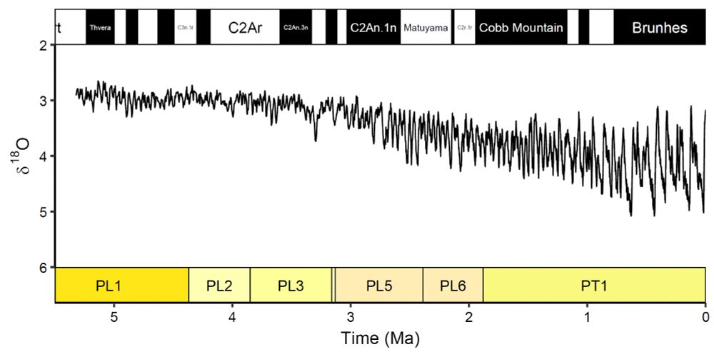
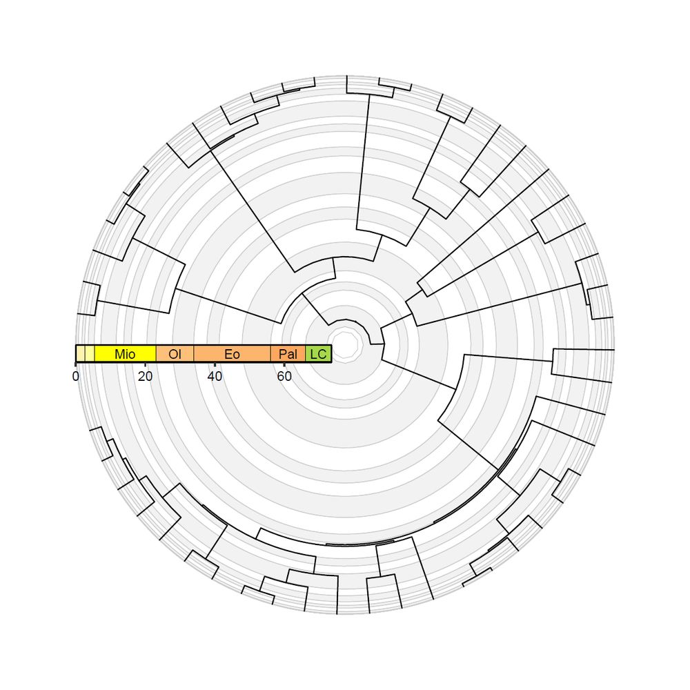
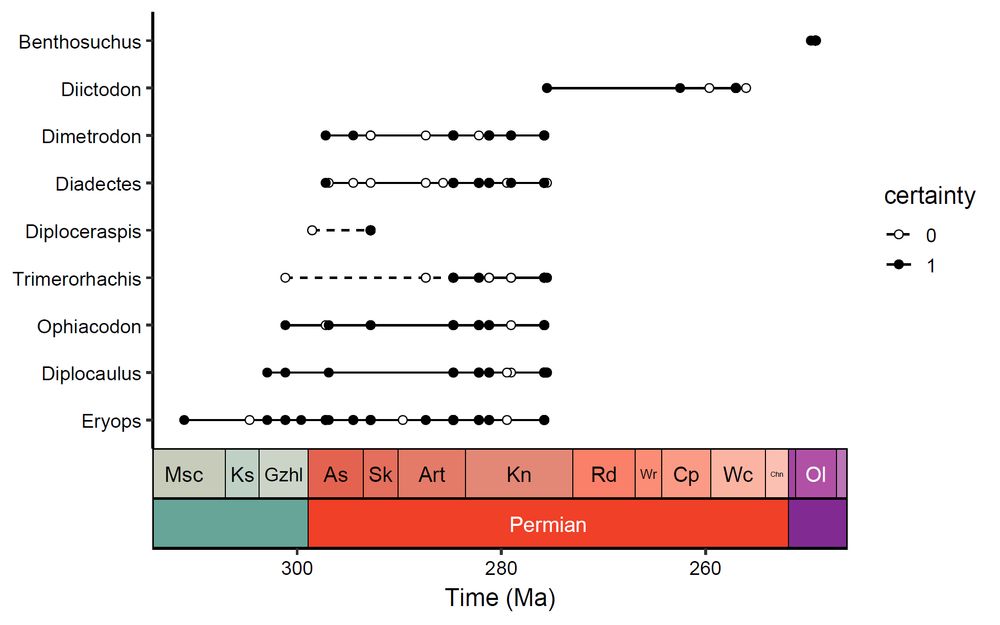
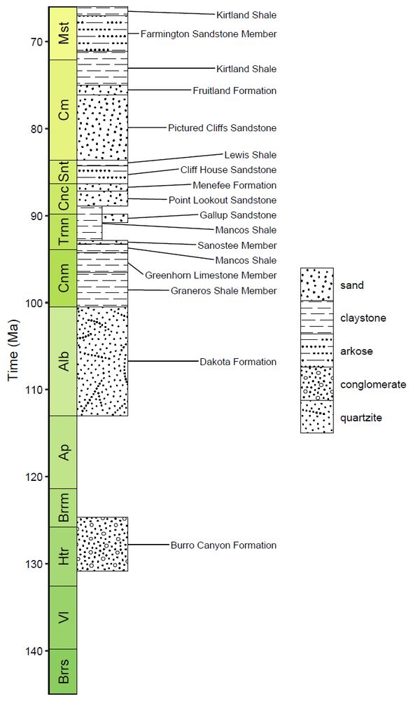
📢deeptime: an #R package that facilitates highly customizable and reproducible visualizations of data over geological time intervals by William Gearty @willgearty.bsky.social
👉https://doi.org/10.1080/20964471.2025.2537516
#Datavisualization #reproducibility #opensource #paleontology #geology
👉https://doi.org/10.1080/20964471.2025.2537516
#Datavisualization #reproducibility #opensource #paleontology #geology
deeptime: an R package that facilitates highly customizable and reproducible visualizations of data over geological time intervals
Data visualization is a key component of any scientific data analysis workflow and is vital for the summarization and dissemination of complex ideas and results. One common hurdle across the Earth ...
doi.org
September 29, 2025 at 9:09 AM
📢deeptime: an #R package that facilitates highly customizable and reproducible visualizations of data over geological time intervals by William Gearty @willgearty.bsky.social
👉https://doi.org/10.1080/20964471.2025.2537516
#Datavisualization #reproducibility #opensource #paleontology #geology
👉https://doi.org/10.1080/20964471.2025.2537516
#Datavisualization #reproducibility #opensource #paleontology #geology
Reposted by Big Earth Data

It's so great to see this package (on CRAN since 2021) finally formally described in a journal! Here's to many more years of standardized, customizable, and reproducible geology data visualization!
And shout out to @richardstockey.bsky.social and @lewisajones.bsky.social for years of encouragement!
And shout out to @richardstockey.bsky.social and @lewisajones.bsky.social for years of encouragement!
August 6, 2025 at 1:15 PM
It's so great to see this package (on CRAN since 2021) finally formally described in a journal! Here's to many more years of standardized, customizable, and reproducible geology data visualization!
And shout out to @richardstockey.bsky.social and @lewisajones.bsky.social for years of encouragement!
And shout out to @richardstockey.bsky.social and @lewisajones.bsky.social for years of encouragement!
📢 [Research Article] A novel ensemble model for multi-temporal forest vegetation classification: integrating spectral-temporal features and topographic constraints
👉Article link: doi.org/10.1080/2096...
💌 #Sentinel1 #Sentinel2 #deeplearning #remotesensing #landuse #landcover #forestmapping
👉Article link: doi.org/10.1080/2096...
💌 #Sentinel1 #Sentinel2 #deeplearning #remotesensing #landuse #landcover #forestmapping
A novel ensemble model for multi-temporal forest vegetation classification: integrating spectral-temporal features and topographic constraints
Understanding species distribution in large forest ecosystems is fundamental for biodiversity conservation, biomass estimation, climate regulation, soil and water conservation. While remote sensing...
doi.org
September 19, 2025 at 9:02 AM
📢 [Research Article] A novel ensemble model for multi-temporal forest vegetation classification: integrating spectral-temporal features and topographic constraints
👉Article link: doi.org/10.1080/2096...
💌 #Sentinel1 #Sentinel2 #deeplearning #remotesensing #landuse #landcover #forestmapping
👉Article link: doi.org/10.1080/2096...
💌 #Sentinel1 #Sentinel2 #deeplearning #remotesensing #landuse #landcover #forestmapping
📢 [Review Article] Harnessing generative AI for enhanced disaster management: a systematic review
👉Article link: doi.org/10.1080/2096...
#Artificialintelligence #disastermanagement #riskmanagement #largelanguagemodel #bigearthdata #digitalearth #geoscience #remotesensing #GIS #risk
👉Article link: doi.org/10.1080/2096...
#Artificialintelligence #disastermanagement #riskmanagement #largelanguagemodel #bigearthdata #digitalearth #geoscience #remotesensing #GIS #risk

Harnessing generative AI for enhanced disaster management: a systematic review
In the consistently evolving artificial intelligence (AI) and large language models (LLMs), many organizations adopt these technologies’ capabilities to solve and assist core operations in many ind...
doi.org
September 10, 2025 at 7:57 AM
📢 [Review Article] Harnessing generative AI for enhanced disaster management: a systematic review
👉Article link: doi.org/10.1080/2096...
#Artificialintelligence #disastermanagement #riskmanagement #largelanguagemodel #bigearthdata #digitalearth #geoscience #remotesensing #GIS #risk
👉Article link: doi.org/10.1080/2096...
#Artificialintelligence #disastermanagement #riskmanagement #largelanguagemodel #bigearthdata #digitalearth #geoscience #remotesensing #GIS #risk
📢Spatial sample weighted machine learning for multitemporal land cover change modeling with imbalanced datasets by Alysha van Duynhoven & Suzana Dragićević
👉https://doi.org/10.1080/20964471.2025.2518763
#machinelearning #landcover #AI #GeoAI #remotesensing #earthobservation #GIS
👉https://doi.org/10.1080/20964471.2025.2518763
#machinelearning #landcover #AI #GeoAI #remotesensing #earthobservation #GIS


September 2, 2025 at 12:24 PM
📢Spatial sample weighted machine learning for multitemporal land cover change modeling with imbalanced datasets by Alysha van Duynhoven & Suzana Dragićević
👉https://doi.org/10.1080/20964471.2025.2518763
#machinelearning #landcover #AI #GeoAI #remotesensing #earthobservation #GIS
👉https://doi.org/10.1080/20964471.2025.2518763
#machinelearning #landcover #AI #GeoAI #remotesensing #earthobservation #GIS
Reposted by Big Earth Data
📢 deeptime: an R package that facilitates highly customizable and reproducible visualizations of data over geological time intervals
🔗 doi.org/10.1080/2096...
Fully #openaccess in @bigearthdata1.bsky.social with insight about deeptime📦 development and code examples!
#rstats #geology #paleontology
🔗 doi.org/10.1080/2096...
Fully #openaccess in @bigearthdata1.bsky.social with insight about deeptime📦 development and code examples!
#rstats #geology #paleontology
August 6, 2025 at 1:06 PM
📢 deeptime: an R package that facilitates highly customizable and reproducible visualizations of data over geological time intervals
🔗 doi.org/10.1080/2096...
Fully #openaccess in @bigearthdata1.bsky.social with insight about deeptime📦 development and code examples!
#rstats #geology #paleontology
🔗 doi.org/10.1080/2096...
Fully #openaccess in @bigearthdata1.bsky.social with insight about deeptime📦 development and code examples!
#rstats #geology #paleontology
📢Simulation of lake underwater terrain based on the XGBoost model: a case study of typical lakes on the #TibetanPlateau
👉https://doi.org/10.1080/20964471.2025.2515713
#lake #underwater #terrain #XGBoost #topography #DEM #waterstorage #bathymetry #climatechange #hydrology #3D #remotesensing #GIS
👉https://doi.org/10.1080/20964471.2025.2515713
#lake #underwater #terrain #XGBoost #topography #DEM #waterstorage #bathymetry #climatechange #hydrology #3D #remotesensing #GIS


August 20, 2025 at 9:37 AM
📢Simulation of lake underwater terrain based on the XGBoost model: a case study of typical lakes on the #TibetanPlateau
👉https://doi.org/10.1080/20964471.2025.2515713
#lake #underwater #terrain #XGBoost #topography #DEM #waterstorage #bathymetry #climatechange #hydrology #3D #remotesensing #GIS
👉https://doi.org/10.1080/20964471.2025.2515713
#lake #underwater #terrain #XGBoost #topography #DEM #waterstorage #bathymetry #climatechange #hydrology #3D #remotesensing #GIS
📢DACIA5: a #Sentinel-1 and #Sentinel-2 #dataset for agricultural #crop identification applications by A. Băicoianu, I. C. Plajer, M. Debu, et al.
👉Article link: doi.org/10.1080/2096...
💌 #Artificialintelligence #agriculture #smartagriculture #remotesensing #machinelearning #datasharing #datapaper
👉Article link: doi.org/10.1080/2096...
💌 #Artificialintelligence #agriculture #smartagriculture #remotesensing #machinelearning #datasharing #datapaper


August 4, 2025 at 6:18 AM
📢DACIA5: a #Sentinel-1 and #Sentinel-2 #dataset for agricultural #crop identification applications by A. Băicoianu, I. C. Plajer, M. Debu, et al.
👉Article link: doi.org/10.1080/2096...
💌 #Artificialintelligence #agriculture #smartagriculture #remotesensing #machinelearning #datasharing #datapaper
👉Article link: doi.org/10.1080/2096...
💌 #Artificialintelligence #agriculture #smartagriculture #remotesensing #machinelearning #datasharing #datapaper
📢[Research Article] Modeling #deforestation drivers in the Brazilian #Amazon: a comparison of quantitative approaches by Alisson Castro Barreto, Tailon Martins & Adriano Mendonça Souza
👉https://doi.org/10.1080/20964471.2025.2510770
#biome #geoscience #GIS #remotesensing #Brazil #statisticalmethod
👉https://doi.org/10.1080/20964471.2025.2510770
#biome #geoscience #GIS #remotesensing #Brazil #statisticalmethod


July 25, 2025 at 10:06 AM
📢[Research Article] Modeling #deforestation drivers in the Brazilian #Amazon: a comparison of quantitative approaches by Alisson Castro Barreto, Tailon Martins & Adriano Mendonça Souza
👉https://doi.org/10.1080/20964471.2025.2510770
#biome #geoscience #GIS #remotesensing #Brazil #statisticalmethod
👉https://doi.org/10.1080/20964471.2025.2510770
#biome #geoscience #GIS #remotesensing #Brazil #statisticalmethod
📢GeoFactory: an #LLM performance enhancement framework for geoscience factual and inferential tasks
👉https://doi.org/10.1080/20964471.2025.2506291
💌A guidance for adapting LLMs to #geoscience applications and paves the way for future multimodal implementations. Largelanguagemodel
👉https://doi.org/10.1080/20964471.2025.2506291
💌A guidance for adapting LLMs to #geoscience applications and paves the way for future multimodal implementations. Largelanguagemodel


July 18, 2025 at 4:10 AM
📢GeoFactory: an #LLM performance enhancement framework for geoscience factual and inferential tasks
👉https://doi.org/10.1080/20964471.2025.2506291
💌A guidance for adapting LLMs to #geoscience applications and paves the way for future multimodal implementations. Largelanguagemodel
👉https://doi.org/10.1080/20964471.2025.2506291
💌A guidance for adapting LLMs to #geoscience applications and paves the way for future multimodal implementations. Largelanguagemodel