


Martin Templin
@bowecho.bsky.social
Ouch, that is a drastic change in intensity of Hurricane #Melissa after crossing Jamaica. Form a historic CAT 5 storm to a roughly CAT 3 storm in a few hours. Source: tropicaltidbits.com/recon/

October 28, 2025 at 10:29 PM
Ouch, that is a drastic change in intensity of Hurricane #Melissa after crossing Jamaica. Form a historic CAT 5 storm to a roughly CAT 3 storm in a few hours. Source: tropicaltidbits.com/recon/
Wider view of Categorie 5-Hurricane #Melissa in the Caribbean. Note the very cold cloud top ring with temps below -80°C of the CDO. Central pressure is around 900 hPa, one of the lowest in Atlantic bassin ever recorded.
October 28, 2025 at 9:15 AM
Wider view of Categorie 5-Hurricane #Melissa in the Caribbean. Note the very cold cloud top ring with temps below -80°C of the CDO. Central pressure is around 900 hPa, one of the lowest in Atlantic bassin ever recorded.
Stunning view of Hurricane #Melissa right now. Note the warm eye surrounded by -80°C cold clouds of the eye wall. This is an indicator of a very strong secondary circulation, leading to further intensification. Note the delta T betwenn the SST and the tropopause is over 100°.
October 27, 2025 at 9:55 AM
Stunning view of Hurricane #Melissa right now. Note the warm eye surrounded by -80°C cold clouds of the eye wall. This is an indicator of a very strong secondary circulation, leading to further intensification. Note the delta T betwenn the SST and the tropopause is over 100°.
Insane Readings from the Hurricane Hunters from Hurricane #Melissa right now. This is a compact storm, note the extrapolated surface pressure gradients. The eye has a temperature of nearly 23°C. That is quiet something. CAT 5 status is likely very near.

October 27, 2025 at 7:26 AM
Insane Readings from the Hurricane Hunters from Hurricane #Melissa right now. This is a compact storm, note the extrapolated surface pressure gradients. The eye has a temperature of nearly 23°C. That is quiet something. CAT 5 status is likely very near.
Wow, Hurricane #Melissa nears stadium effect. Please not that the Cloud Top Temps are really cold for an Atlantic Bassin Storm with wide areas below -80°C. This system is approaching Category 5 intensity right now, imho.
October 26, 2025 at 7:17 AM
Wow, Hurricane #Melissa nears stadium effect. Please not that the Cloud Top Temps are really cold for an Atlantic Bassin Storm with wide areas below -80°C. This system is approaching Category 5 intensity right now, imho.
Etwas überraschend hat der Wetterdienst in Grad Forks, North Dakota einen #Tornado, der am 20.6.2025 auftrat auf die höchste Kategorie 5 hochgestuft. Seit nun mehr 12 Jahren hatte es keinen EF-5 mehr gegeben!

The Enderlin, ND tornado from 6/20/25 has been upgraded to EF5.
October 6, 2025 at 3:05 PM
Etwas überraschend hat der Wetterdienst in Grad Forks, North Dakota einen #Tornado, der am 20.6.2025 auftrat auf die höchste Kategorie 5 hochgestuft. Seit nun mehr 12 Jahren hatte es keinen EF-5 mehr gegeben!
A Stingjet has developed by #StormAmy. Note the cloud head and the descending cloud bands into the dry air coming down from the tropopause. The scotish westcoast is in for a hefty ride right now, expect intense winds there now.
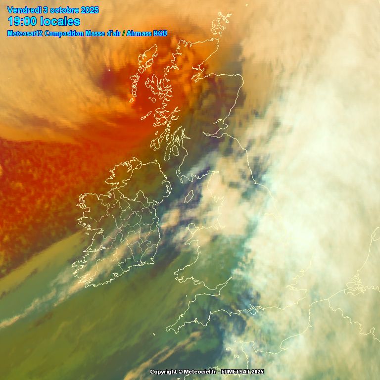
October 3, 2025 at 5:23 PM
A Stingjet has developed by #StormAmy. Note the cloud head and the descending cloud bands into the dry air coming down from the tropopause. The scotish westcoast is in for a hefty ride right now, expect intense winds there now.
The developing extratropical low #AMY #stormamy will possibly develope into a Shapiro-Keyser Cyclone with a risk of a Sting Jet. This might happen over the ocean, still gusts over 140 km/h are likely in northern Ireland and Scotland.
Source: wetter3.de
Source: wetter3.de
October 1, 2025 at 1:05 PM
The developing extratropical low #AMY #stormamy will possibly develope into a Shapiro-Keyser Cyclone with a risk of a Sting Jet. This might happen over the ocean, still gusts over 140 km/h are likely in northern Ireland and Scotland.
Source: wetter3.de
Source: wetter3.de
Lots of lightnings in the eye of CAT 5 Storm #Humberto. That is a signal of intense convection, henceforth the system is still strengthening.
September 27, 2025 at 9:20 PM
Lots of lightnings in the eye of CAT 5 Storm #Humberto. That is a signal of intense convection, henceforth the system is still strengthening.
A textbook animation of #Humberto's structure. A very well defined eye and multiple spiral band. This is nearing Cat 5 strength right now. Source: tropic.ssec.wisc.edu/real-time/mi...
September 27, 2025 at 8:41 PM
A textbook animation of #Humberto's structure. A very well defined eye and multiple spiral band. This is nearing Cat 5 strength right now. Source: tropic.ssec.wisc.edu/real-time/mi...
Another beautiful animation of rapidly intensifiying Hurricane #Humberto right now. I think a recon mission by the Hurricne Hunters would bring light into the real intensity right now. Besides this no doubt that further intensification can be anticipated.
September 26, 2025 at 6:37 PM
Another beautiful animation of rapidly intensifiying Hurricane #Humberto right now. I think a recon mission by the Hurricne Hunters would bring light into the real intensity right now. Besides this no doubt that further intensification can be anticipated.
The Typhon #RAGASA is showing up on the Taiwan Radar. The spiral bands are already reaching the island. On the right lower side the eye is starting to get visible. It is far distant of the radar and the radar signal is damped by the thunderstorms in the spiral bands.

September 21, 2025 at 9:51 PM
The Typhon #RAGASA is showing up on the Taiwan Radar. The spiral bands are already reaching the island. On the right lower side the eye is starting to get visible. It is far distant of the radar and the radar signal is damped by the thunderstorms in the spiral bands.
What a textbook structure here on Super Typhoon #RAGASA in this Microwave Image. A solid core surrounded by multiple spiral bands. Very intense eyewall convection immanent. Pressure nearing the 900 hPa mark again as the EWRC is succesfully done. Source: tropic.ssec.wisc.edu/tropic.php

September 21, 2025 at 8:57 PM
What a textbook structure here on Super Typhoon #RAGASA in this Microwave Image. A solid core surrounded by multiple spiral bands. Very intense eyewall convection immanent. Pressure nearing the 900 hPa mark again as the EWRC is succesfully done. Source: tropic.ssec.wisc.edu/tropic.php
Der Typhoon #Ragasa im Westpazifik vor der Küste der Phillipinen. Was für ein prächtiger Sturm, noch ein paar Stunden und er erreicht wahrscheinlcih die höchste Kategorie 5 auf der Saffir-Simpson Skala. Quelle: www.tropicaltidbits.com/storminfo/#24W
September 21, 2025 at 6:46 AM
Der Typhoon #Ragasa im Westpazifik vor der Küste der Phillipinen. Was für ein prächtiger Sturm, noch ein paar Stunden und er erreicht wahrscheinlcih die höchste Kategorie 5 auf der Saffir-Simpson Skala. Quelle: www.tropicaltidbits.com/storminfo/#24W
#Mondfinsternis vom Büro aus gesehen.

September 7, 2025 at 6:42 PM
#Mondfinsternis vom Büro aus gesehen.
Hier die Auswertung der Tageshöchsttemperatur für meine Heimat Schleswig-Holstein. In meinem Urlaub (19.7. bis 3.8.) sieht man eindrücklich, dass leider fast alle Tage unterdurchschnittlich waren. Also hatte ich in Summe die schlechtesten zwei Wochen erwischt. 😬

September 1, 2025 at 11:05 AM
Hier die Auswertung der Tageshöchsttemperatur für meine Heimat Schleswig-Holstein. In meinem Urlaub (19.7. bis 3.8.) sieht man eindrücklich, dass leider fast alle Tage unterdurchschnittlich waren. Also hatte ich in Summe die schlechtesten zwei Wochen erwischt. 😬
24 hours of intensification of #Erin in the microwave perspective. What a textbook loop with a concentric eye and multiple spiral bands. It is awesome that CIMSS is publishing these animations.

August 17, 2025 at 1:44 PM
24 hours of intensification of #Erin in the microwave perspective. What a textbook loop with a concentric eye and multiple spiral bands. It is awesome that CIMSS is publishing these animations.
Wow, look at these readings. A stadium effect immanent and flight level winds nearing 160 kt. This is close if not a Category 5 Hurricane right now. Eye temperature over 25°C and pressure down nearing 925 hPa. #Erin


August 16, 2025 at 1:49 PM
Wow, look at these readings. A stadium effect immanent and flight level winds nearing 160 kt. This is close if not a Category 5 Hurricane right now. Eye temperature over 25°C and pressure down nearing 925 hPa. #Erin
Hurricane #Erin is the first Atlantic #Hurricane of the season, obviously CAT 1 right now. The season has kicked off. The storm should stay offshore for most of it's time, only Bermuda seems to be in a low threat for now, but things can change!
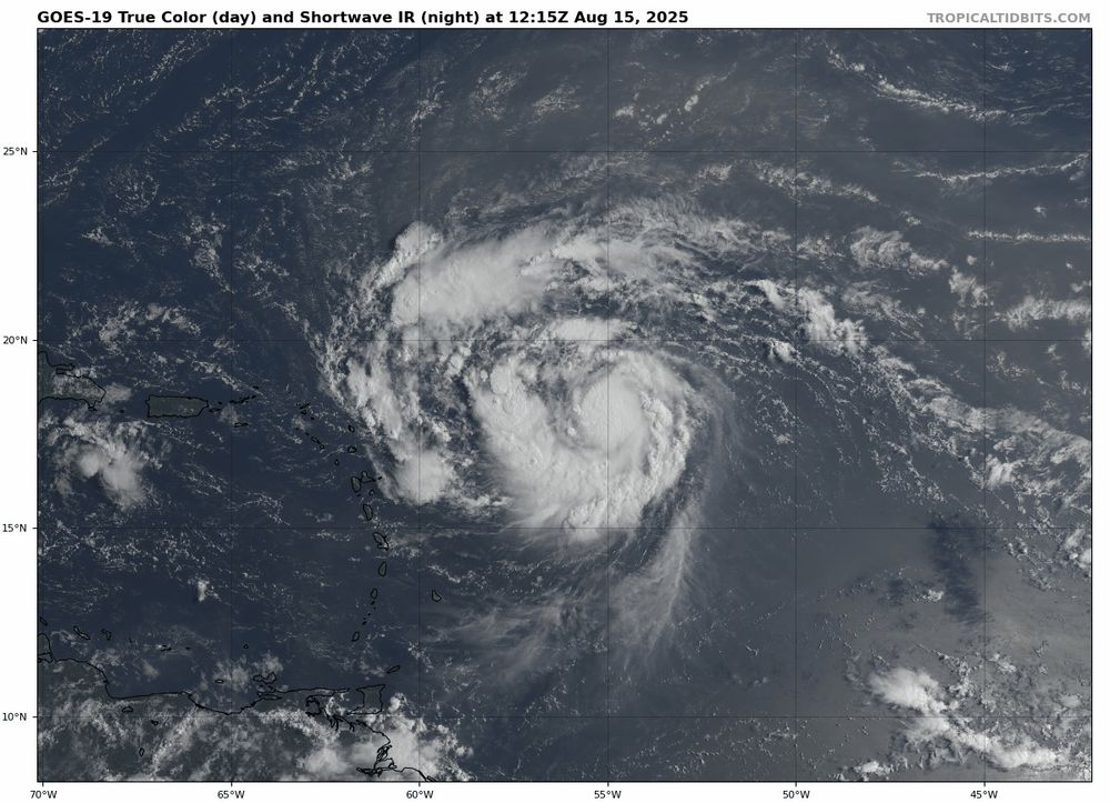
August 15, 2025 at 2:52 PM
Hurricane #Erin is the first Atlantic #Hurricane of the season, obviously CAT 1 right now. The season has kicked off. The storm should stay offshore for most of it's time, only Bermuda seems to be in a low threat for now, but things can change!