


Mike Charnick
@charnick.bsky.social
Meteorologist living & working in Colorado and Wyoming. Hobby photographer, mountaineer, trail runner & storm chaser.🌪 📸 🏔🏃♂️
Greetings from Africa! This is Kevin. Everyone say hello to Kevin! This is one of only ~1,000 remaining Mountain Gorillas left in the world. We were lucky enough to spend some time with this amazing gorilla family in Volcanoes National Park in Rwanda.

January 24, 2026 at 12:05 AM
Greetings from Africa! This is Kevin. Everyone say hello to Kevin! This is one of only ~1,000 remaining Mountain Gorillas left in the world. We were lucky enough to spend some time with this amazing gorilla family in Volcanoes National Park in Rwanda.
First light after the storm on the stunning Cuernos del Paine mountains - Chilean #Patagonia, 2025.
A powerful late-spring blizzard dropped several meters of snow on the southern Andes during during the first days of our trip. Once the skies finally broke, the views were incredible!
#Chile #sunrise
A powerful late-spring blizzard dropped several meters of snow on the southern Andes during during the first days of our trip. Once the skies finally broke, the views were incredible!
#Chile #sunrise

January 15, 2026 at 11:49 PM
First light after the storm on the stunning Cuernos del Paine mountains - Chilean #Patagonia, 2025.
A powerful late-spring blizzard dropped several meters of snow on the southern Andes during during the first days of our trip. Once the skies finally broke, the views were incredible!
#Chile #sunrise
A powerful late-spring blizzard dropped several meters of snow on the southern Andes during during the first days of our trip. Once the skies finally broke, the views were incredible!
#Chile #sunrise
The legendary Fitz Roy at sunrise above Cascada Escondida. Patagonia at its finest!
El Chaltean, Argentina 2025.
#patagonia #fitzroy #photography #sunrise #waterfall
El Chaltean, Argentina 2025.
#patagonia #fitzroy #photography #sunrise #waterfall

December 31, 2025 at 7:23 AM
The legendary Fitz Roy at sunrise above Cascada Escondida. Patagonia at its finest!
El Chaltean, Argentina 2025.
#patagonia #fitzroy #photography #sunrise #waterfall
El Chaltean, Argentina 2025.
#patagonia #fitzroy #photography #sunrise #waterfall
So close and yet so far…just a bit west of a big-time South American dryline severe weather day. Looks like some supercells in there too. Would love to experience one of these in the future, but not on this trip!


November 15, 2025 at 10:58 PM
So close and yet so far…just a bit west of a big-time South American dryline severe weather day. Looks like some supercells in there too. Would love to experience one of these in the future, but not on this trip!
Chugwater, Wyoming around 9:30pm 11/12. Not as vivid as last night but a nice green glow and some diffuse red pillars! #aurora #wywx #northernlights

November 13, 2025 at 5:03 AM
Chugwater, Wyoming around 9:30pm 11/12. Not as vivid as last night but a nice green glow and some diffuse red pillars! #aurora #wywx #northernlights

Rather epic scene outside of NWS Cheyenne right now…covering an evening shift and got some nice photos around the office! #Wyoming #wywx #aurora #northernlights

November 12, 2025 at 3:09 AM
Rather epic scene outside of NWS Cheyenne right now…covering an evening shift and got some nice photos around the office! #Wyoming #wywx #aurora #northernlights
Incredible Sentinal-2 satellite imagery of #Melissa at peak intensity before landfall. In the cloud-free areas of the eye you can see the physical effect of the surface wind gradient (2nd image): chaotic whitecapped waves near center transition to extreme sea spray/linear streaking near the eyewall!


October 29, 2025 at 12:26 AM
Incredible Sentinal-2 satellite imagery of #Melissa at peak intensity before landfall. In the cloud-free areas of the eye you can see the physical effect of the surface wind gradient (2nd image): chaotic whitecapped waves near center transition to extreme sea spray/linear streaking near the eyewall!
#Comet #Lemmon last weekend, with both the ion and dust tails visible. The ion tail (thin one) was shocked by a solar storm the day before, resulting in a fractured look.
30x20s exposures at 600mm. Star trails in the b-round due to the comet itself moving over the ~10m of imaging. #astro
30x20s exposures at 600mm. Star trails in the b-round due to the comet itself moving over the ~10m of imaging. #astro

October 26, 2025 at 12:44 AM
A year ago tonight over the Medicine Bow mountains in Wyoming! This was the same G5 geomagnetic storm that gave many folks along the east coast urban corridor their first view of aurora. Enjoy! ✨
#solarstorm #aurora #auroraborealis #WYwx
#solarstorm #aurora #auroraborealis #WYwx

October 11, 2025 at 5:03 AM
A year ago tonight over the Medicine Bow mountains in Wyoming! This was the same G5 geomagnetic storm that gave many folks along the east coast urban corridor their first view of aurora. Enjoy! ✨
#solarstorm #aurora #auroraborealis #WYwx
#solarstorm #aurora #auroraborealis #WYwx

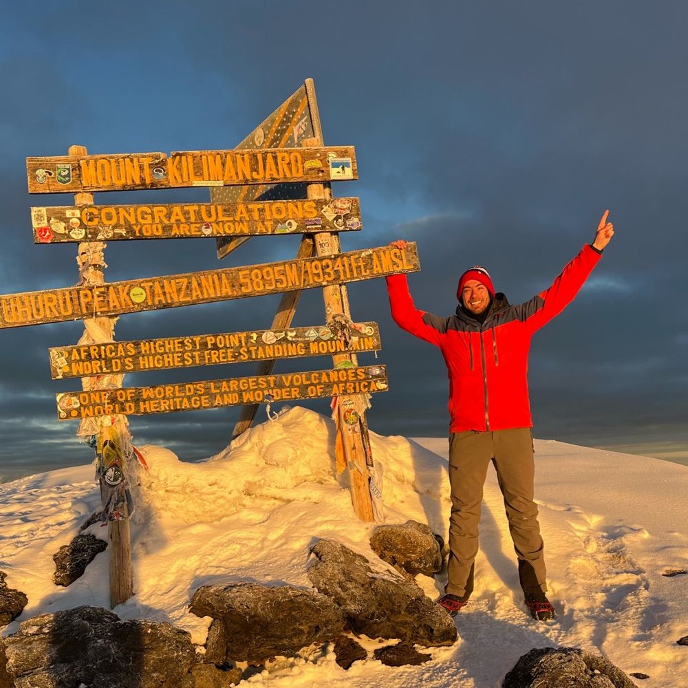
Earlier this summer, an opportunity presented itself to climb the Montana state highpoint: Granite Peak in the Beartooth Range. This was my last of the Lower 48 "Big 3". A brutal 2-day push to bag the peak, what a beautiful reward to get to exist in some of the more remote wilderness in the US!#MTwx


September 26, 2025 at 9:35 PM
Earlier this summer, an opportunity presented itself to climb the Montana state highpoint: Granite Peak in the Beartooth Range. This was my last of the Lower 48 "Big 3". A brutal 2-day push to bag the peak, what a beautiful reward to get to exist in some of the more remote wilderness in the US!#MTwx

August 29, 2025 at 9:12 PM
🚨It's happening people! THIS IS NOT A DRILL! 🚨
Spotted yesterday 8/28 in southeast Wyoming. Summer is OVER! 💪❄️
Spotted yesterday 8/28 in southeast Wyoming. Summer is OVER! 💪❄️

August 29, 2025 at 9:05 PM
🚨It's happening people! THIS IS NOT A DRILL! 🚨
Spotted yesterday 8/28 in southeast Wyoming. Summer is OVER! 💪❄️
Spotted yesterday 8/28 in southeast Wyoming. Summer is OVER! 💪❄️

July 31, 2025 at 3:00 AM

While waiting for a weather window to summit Rainier, we saw several epic lenticular/cap clouds over the summit throughout the week. This telephoto view was particularly wild - a combo of stratified lenticular clouds over the summit & convective surface clouds underneath. #wawx #Rainier

July 31, 2025 at 12:22 AM
Mount Rainier- State highpoint #40!
The theme of this trip was resilience. A self-guided climb was certainly an added challenge and really forced competence with crevasse rescue skills and route finding. Got the weather window we needed & gutted out 9,200’ to what I’d consider my hardest summit yet!
The theme of this trip was resilience. A self-guided climb was certainly an added challenge and really forced competence with crevasse rescue skills and route finding. Got the weather window we needed & gutted out 9,200’ to what I’d consider my hardest summit yet!


July 13, 2025 at 9:26 PM
Mount Rainier- State highpoint #40!
The theme of this trip was resilience. A self-guided climb was certainly an added challenge and really forced competence with crevasse rescue skills and route finding. Got the weather window we needed & gutted out 9,200’ to what I’d consider my hardest summit yet!
The theme of this trip was resilience. A self-guided climb was certainly an added challenge and really forced competence with crevasse rescue skills and route finding. Got the weather window we needed & gutted out 9,200’ to what I’d consider my hardest summit yet!
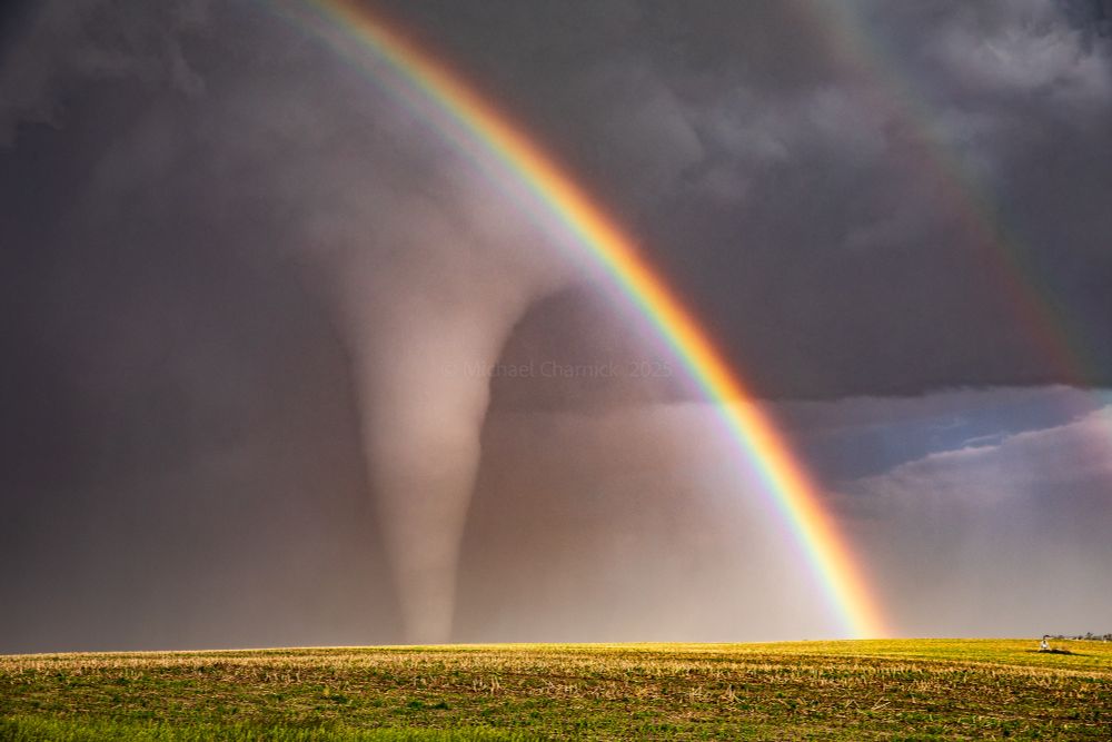
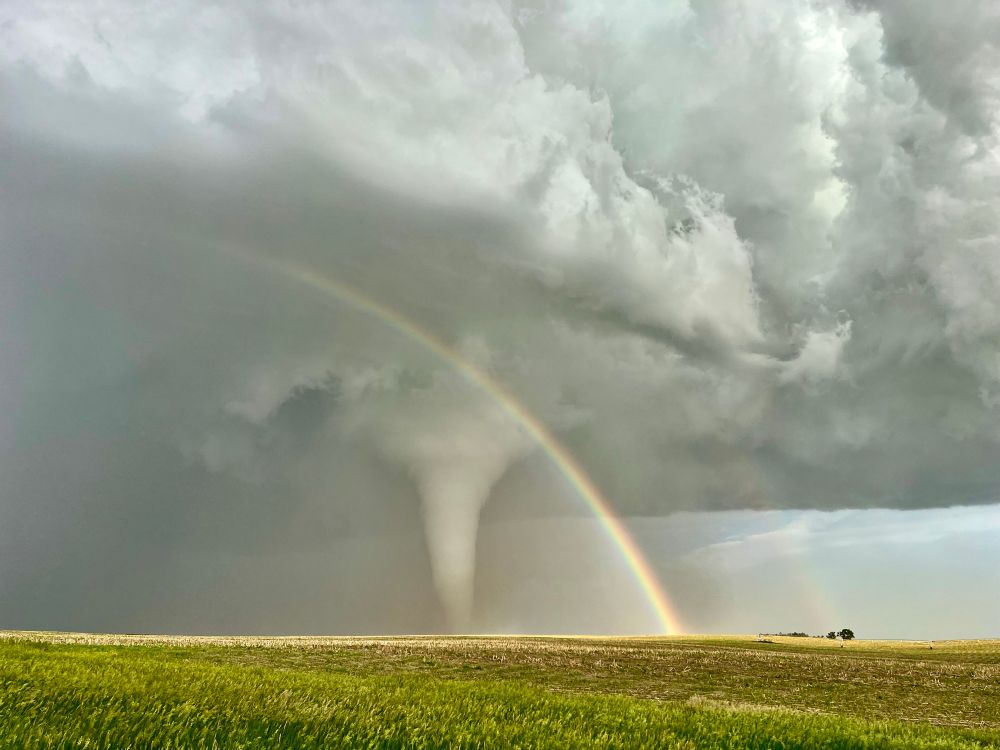
Still riding the high of this tornado chase a few weeks later. Here is a slightly more cleaned-up edit of the best tornado + rainbow + RFD storm structure I'll probably ever see. Enjoy!
Dickens/Whitman, NE 6/16/25
Dickens/Whitman, NE 6/16/25

July 4, 2025 at 4:45 PM
Still riding the high of this tornado chase a few weeks later. Here is a slightly more cleaned-up edit of the best tornado + rainbow + RFD storm structure I'll probably ever see. Enjoy!
Dickens/Whitman, NE 6/16/25
Dickens/Whitman, NE 6/16/25
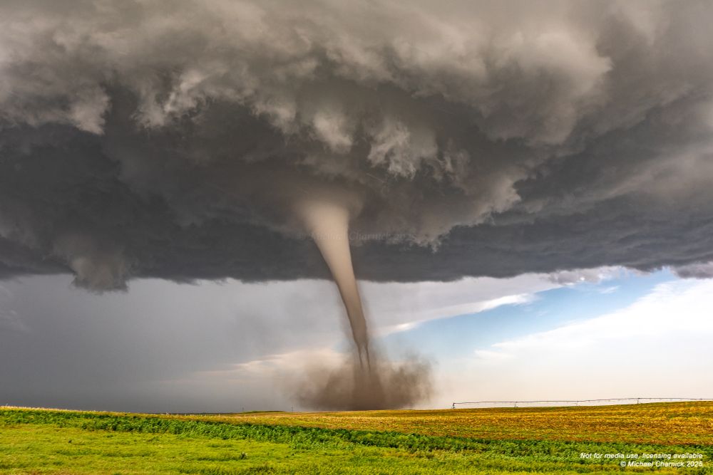
This was a particularly fascinating photo of the Dickens tornado. The bottom 1/3 of the condensed tornado appeared to 'hollow out' leaving just the shell of the circulation condensed, surrounded by dust. If you look closely the residual condensation takes on a 'braided' look similar to vinyl tubing.
June 19, 2025 at 5:38 PM
This was a particularly fascinating photo of the Dickens tornado. The bottom 1/3 of the condensed tornado appeared to 'hollow out' leaving just the shell of the circulation condensed, surrounded by dust. If you look closely the residual condensation takes on a 'braided' look similar to vinyl tubing.
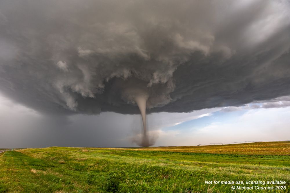
The perfect tornado.
16mm full wide. Dickens, Nebraska. 6/16/25
16mm full wide. Dickens, Nebraska. 6/16/25
June 19, 2025 at 1:48 AM
The perfect tornado.
16mm full wide. Dickens, Nebraska. 6/16/25
16mm full wide. Dickens, Nebraska. 6/16/25
Yesterday’s Panhandle supercell in OK remained just-so-slightly elevated fighting stable air behind the morning OFB. Viewed from the NE the base had a laminar appearance despite robust convection aloft. Views inside the RFD show the effects of stable air as various occlusions tried & failed to wrap!


June 18, 2025 at 9:07 PM
Yesterday’s Panhandle supercell in OK remained just-so-slightly elevated fighting stable air behind the morning OFB. Viewed from the NE the base had a laminar appearance despite robust convection aloft. Views inside the RFD show the effects of stable air as various occlusions tried & failed to wrap!
Single shot 70mm from yesterday. Ghostly. Etherial. And a photo I'll probably never be able to top!
Dickens, Nebraska. 6/16/25
Dickens, Nebraska. 6/16/25
June 17, 2025 at 4:38 PM
Single shot 70mm from yesterday. Ghostly. Etherial. And a photo I'll probably never be able to top!
Dickens, Nebraska. 6/16/25
Dickens, Nebraska. 6/16/25
Absolute insanity Dickens Nebraska tornado a bit ago at close range! Right off the iPhone lens spots and all!

June 17, 2025 at 2:20 AM
Absolute insanity Dickens Nebraska tornado a bit ago at close range! Right off the iPhone lens spots and all!
Career tornado intercept just now Dickens Nebraska!
June 17, 2025 at 1:34 AM
Career tornado intercept just now Dickens Nebraska!