


Chris Kuball
@chriskuball.bsky.social
Meteorologist at We Are Iowa - Local 5 in West Des Moines, Iowa
Iowa State University Graduate and Fanatic
641>515>507>515
Iowa State University Graduate and Fanatic
641>515>507>515
It's BAAAACK! The POET tree near Hanlontown is illuminated for another season! Such a beautiful tree that is isolated along the Iowa farm fields. Want to take a peak? This is just west of I35 on Iowa Highway 9 in north Iowa. Worth the short detour.
📷Steve Yezek
📍Hanlontown, IA
#ChristmasLights
📷Steve Yezek
📍Hanlontown, IA
#ChristmasLights

November 30, 2025 at 3:43 PM
It's BAAAACK! The POET tree near Hanlontown is illuminated for another season! Such a beautiful tree that is isolated along the Iowa farm fields. Want to take a peak? This is just west of I35 on Iowa Highway 9 in north Iowa. Worth the short detour.
📷Steve Yezek
📍Hanlontown, IA
#ChristmasLights
📷Steve Yezek
📍Hanlontown, IA
#ChristmasLights

In progress snow amounts over southern Minnesota and north Iowa. Snow is still falling so totals will continue to rise as new reports come in. Call out your amounts in the comments!

November 30, 2025 at 12:19 AM
In progress snow amounts over southern Minnesota and north Iowa. Snow is still falling so totals will continue to rise as new reports come in. Call out your amounts in the comments!

9". Snow problem. Had a good band over town to boost totals through the middle of the day. Looks like southern Iowa is going to come in under expectations. But those especially north of I80 got the hammer. Not quite done yet as some snow still flies.
November 29, 2025 at 9:57 PM
9". Snow problem. Had a good band over town to boost totals through the middle of the day. Looks like southern Iowa is going to come in under expectations. But those especially north of I80 got the hammer. Not quite done yet as some snow still flies.
Just a mess up by Ackley and Wellsburg where a foot or more of snow is on the ground! Here's the view from a plow cam up in that area!

November 29, 2025 at 6:15 PM
Just a mess up by Ackley and Wellsburg where a foot or more of snow is on the ground! Here's the view from a plow cam up in that area!
Another look at road conditions across Iowa Saturday afternoon.😂

November 29, 2025 at 6:05 PM
Another look at road conditions across Iowa Saturday afternoon.😂
A few of the highest snow reports so far from Iowa. Some big time numbers along the US 20 corridor. 11" in Fort Dodge, Iowa Falls and Stratford. Call out yours in the comments. What's it look like out there?

November 29, 2025 at 5:52 PM
A few of the highest snow reports so far from Iowa. Some big time numbers along the US 20 corridor. 11" in Fort Dodge, Iowa Falls and Stratford. Call out yours in the comments. What's it look like out there?
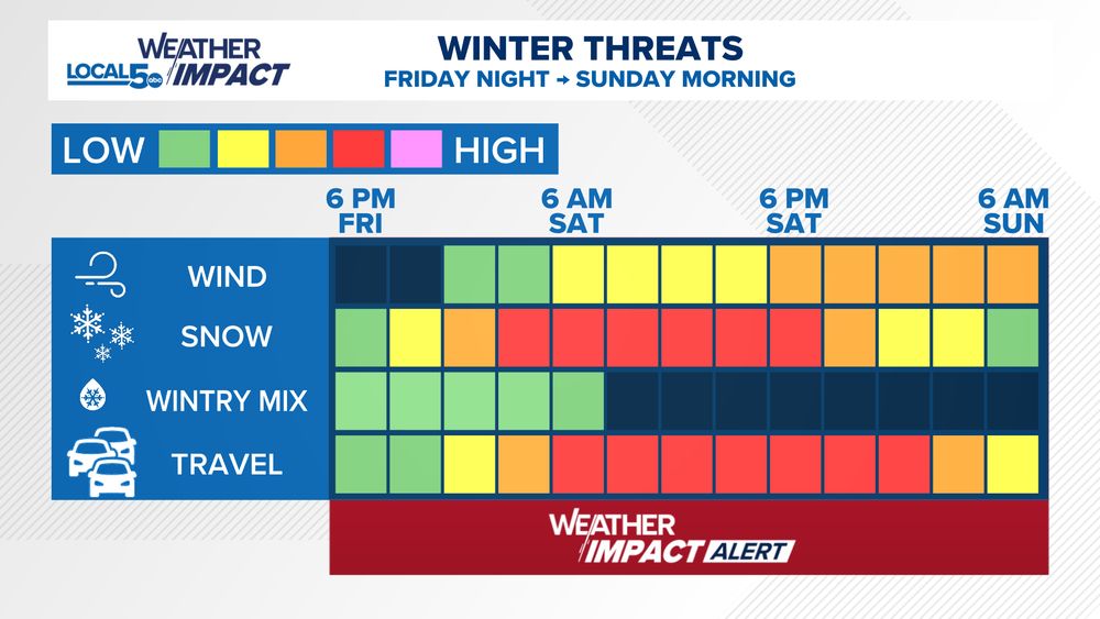
An estimated timeline for our winter storm impacts in central Iowa. Heavy snow causes most of the problems right through the heart of Saturday. Wind will kick up a bit for Saturday night to further stir snow up on the travel scene. Hazardous driving expected Friday night to Sunday morning.
November 28, 2025 at 3:11 AM
An estimated timeline for our winter storm impacts in central Iowa. Heavy snow causes most of the problems right through the heart of Saturday. Wind will kick up a bit for Saturday night to further stir snow up on the travel scene. Hazardous driving expected Friday night to Sunday morning.
Snow takes over Friday night and becomes the heaviest into Saturday. Here's an hourly breakdown of the storm as it kicks off. Southwest Iowa will have an element of wintry mix at onset. Expect big travel disruptions across the state especially from Saturday morning to Sunday morning. #IAWX


November 28, 2025 at 12:15 AM
Snow takes over Friday night and becomes the heaviest into Saturday. Here's an hourly breakdown of the storm as it kicks off. Southwest Iowa will have an element of wintry mix at onset. Expect big travel disruptions across the state especially from Saturday morning to Sunday morning. #IAWX


Meanwhile in Western Minnesota near the South Dakota state line on US 12. This area was in a blizzard warning earlier this evening. You can see why by looking at this plow cam as of 9 PM.

November 26, 2025 at 3:17 AM
Meanwhile in Western Minnesota near the South Dakota state line on US 12. This area was in a blizzard warning earlier this evening. You can see why by looking at this plow cam as of 9 PM.
That wind is legit over the western half of Iowa. Commonly finding wind gusts running 50-55 mph from the NW this evening. Having first hand driving in rural areas just now, please use caution out there tonight as the strongest pushes eastward. Peak gusts as of 8:45pm #IAWX #MNWX


November 26, 2025 at 2:47 AM
Lots of talk about a storm this weekend. Look what's in behind it to. Looking like it will easily be our coldest airmass of the season. Single digit lows (if not colder) and wind chills in the 0s to -10s if conditions align. Long ways out but something to track.

November 26, 2025 at 12:37 AM
Lots of talk about a storm this weekend. Look what's in behind it to. Looking like it will easily be our coldest airmass of the season. Single digit lows (if not colder) and wind chills in the 0s to -10s if conditions align. Long ways out but something to track.
High profile vehicles take note. Wind gusts 45-55 mph will be common between 8 PM and 4 AM Tuesday night into Wednesday. Some gusts may run as high as 60 mph.
A dash of snow is possible north of US 20 which should serve to reduce visibility when falling snow + wind overlap.
A dash of snow is possible north of US 20 which should serve to reduce visibility when falling snow + wind overlap.

November 25, 2025 at 11:48 PM
High profile vehicles take note. Wind gusts 45-55 mph will be common between 8 PM and 4 AM Tuesday night into Wednesday. Some gusts may run as high as 60 mph.
A dash of snow is possible north of US 20 which should serve to reduce visibility when falling snow + wind overlap.
A dash of snow is possible north of US 20 which should serve to reduce visibility when falling snow + wind overlap.
Snow is taking over NW Minnesota. Here's a look along I94 near Evansville SE of Fergus Falls. Poor travel conditions will expand eastward across the state through tonight. Snow covered roads will make travel difficult in many spots across Minnesota into Wednesday. #MNWX

November 25, 2025 at 7:57 PM
Snow is taking over NW Minnesota. Here's a look along I94 near Evansville SE of Fergus Falls. Poor travel conditions will expand eastward across the state through tonight. Snow covered roads will make travel difficult in many spots across Minnesota into Wednesday. #MNWX
A huge temperature shift in the forecast for Thursday. Snow to follow. ;)

November 25, 2025 at 2:31 AM
A huge temperature shift in the forecast for Thursday. Snow to follow. ;)


For Late-November... I think both Cyclone and Hawkeye fans will take this.
49 at kickoff up in Ames. Warming to the 50s. One thing to watch is the breeze. We all know it swirls around pretty good at Jack Trice.
Mid 50s at kickoff in Iowa City, holding through the game.
49 at kickoff up in Ames. Warming to the 50s. One thing to watch is the breeze. We all know it swirls around pretty good at Jack Trice.
Mid 50s at kickoff in Iowa City, holding through the game.


November 22, 2025 at 4:09 AM
For Late-November... I think both Cyclone and Hawkeye fans will take this.
49 at kickoff up in Ames. Warming to the 50s. One thing to watch is the breeze. We all know it swirls around pretty good at Jack Trice.
Mid 50s at kickoff in Iowa City, holding through the game.
49 at kickoff up in Ames. Warming to the 50s. One thing to watch is the breeze. We all know it swirls around pretty good at Jack Trice.
Mid 50s at kickoff in Iowa City, holding through the game.


Here's why your Thursday has a Tricky Temperature Forecast. This potential 50s will be squandered by low clouds and fog. Expect the 40s to hold another day.
November 20, 2025 at 12:27 AM
Here's why your Thursday has a Tricky Temperature Forecast. This potential 50s will be squandered by low clouds and fog. Expect the 40s to hold another day.
So close to being on #Weathergami watch in Des Moines. A Weathergami is a unique high/low combination that has never happened before. Today's High/Low is 44/41 so far. That combination (if it holds) has only happened 3 other times in the record book that dates back to 1878.
#SoClose #IAWX
#SoClose #IAWX

November 19, 2025 at 8:13 PM
So close to being on #Weathergami watch in Des Moines. A Weathergami is a unique high/low combination that has never happened before. Today's High/Low is 44/41 so far. That combination (if it holds) has only happened 3 other times in the record book that dates back to 1878.
#SoClose #IAWX
#SoClose #IAWX
Get ready for a big burst of Arctic Air arriving in the Midwest around Thanksgiving and lasting through the holiday weekend. How we get there and how extreme is still a bit up in the air. But at minimum we'll see a push back to below normal temps in that timeframe.


November 18, 2025 at 11:09 PM
Get ready for a big burst of Arctic Air arriving in the Midwest around Thanksgiving and lasting through the holiday weekend. How we get there and how extreme is still a bit up in the air. But at minimum we'll see a push back to below normal temps in that timeframe.