


CoCoRaHS Station KY-JC-6
@cocorahskyjc6.bsky.social
Community Collaborative Rain, Hail, & Snow volunteer (https://dex.cocorahs.org/stations/KY-JC-6), #CWOP volunteer & storm spotter in the Daniel Boone N.F. for NWS JKL/LMK plus operate WU PWS KKYMCKEE41 https://wunderground.com/dashboard/pws/KKYMCKEE41.
24 Nov 2025 Climate Summary for #nwsjacksonky, #kymesonet, #DanielBooneNF, & other interests.
High: 62.4°F
Low: 33.0°F
Pcpn.: 0.00"
Snow: 0.0"
Snow Depth: 0.0"
More #wxdata may be found 24/7/365 at wunderground.com/dashboard/pw... #ekywx #kywx #CWOP #ShareYourWeather
High: 62.4°F
Low: 33.0°F
Pcpn.: 0.00"
Snow: 0.0"
Snow Depth: 0.0"
More #wxdata may be found 24/7/365 at wunderground.com/dashboard/pw... #ekywx #kywx #CWOP #ShareYourWeather
Personal Weather Station Dashboard | Weather Underground
Weather Underground provides local & long-range weather forecasts, weather reports, maps & tropical weather conditions for locations worldwide.
wunderground.com
November 25, 2025 at 4:03 AM
24 Nov 2025 Climate Summary for #nwsjacksonky, #kymesonet, #DanielBooneNF, & other interests.
High: 62.4°F
Low: 33.0°F
Pcpn.: 0.00"
Snow: 0.0"
Snow Depth: 0.0"
More #wxdata may be found 24/7/365 at wunderground.com/dashboard/pw... #ekywx #kywx #CWOP #ShareYourWeather
High: 62.4°F
Low: 33.0°F
Pcpn.: 0.00"
Snow: 0.0"
Snow Depth: 0.0"
More #wxdata may be found 24/7/365 at wunderground.com/dashboard/pw... #ekywx #kywx #CWOP #ShareYourWeather
24 Nov 2025 daily observation report using a #CoCoRaHS-approved #CLIMALYTIC Tropo Rain/Snow Gauge along with a #Logia 7-in-1 #WiFi #PWS (Model LOWSC710SWB).
This location reports #wxdata 24/7/365 to #weathercloud & at wunderground.com/dashboard/pws/KKYMCKEE41 #CWOP #ShareYourWeather #ekywx #kywx
This location reports #wxdata 24/7/365 to #weathercloud & at wunderground.com/dashboard/pws/KKYMCKEE41 #CWOP #ShareYourWeather #ekywx #kywx


November 24, 2025 at 1:10 PM
24 Nov 2025 daily observation report using a #CoCoRaHS-approved #CLIMALYTIC Tropo Rain/Snow Gauge along with a #Logia 7-in-1 #WiFi #PWS (Model LOWSC710SWB).
This location reports #wxdata 24/7/365 to #weathercloud & at wunderground.com/dashboard/pws/KKYMCKEE41 #CWOP #ShareYourWeather #ekywx #kywx
This location reports #wxdata 24/7/365 to #weathercloud & at wunderground.com/dashboard/pws/KKYMCKEE41 #CWOP #ShareYourWeather #ekywx #kywx
23 Nov 2025 Climate Summary near the #HorseLickCreekBioreserveArea, #JacksonCountyKy in the #DanielBooneNF
High: 59.0°F
Low: 37.9°F
Precip: 0.00"
Snow: 0.0"
Snow Depth: 0.0"
More #wxdata may be found 24/7/365 at wunderground.com/dashboard/pws/KKYMCKEE41 #ekywx #kywx #CWOP #ShareYourWeather
High: 59.0°F
Low: 37.9°F
Precip: 0.00"
Snow: 0.0"
Snow Depth: 0.0"
More #wxdata may be found 24/7/365 at wunderground.com/dashboard/pws/KKYMCKEE41 #ekywx #kywx #CWOP #ShareYourWeather
Personal Weather Station Dashboard | Weather Underground
Weather Underground provides local & long-range weather forecasts, weather reports, maps & tropical weather conditions for locations worldwide.
wunderground.com
November 24, 2025 at 12:48 PM
23 Nov 2025 Climate Summary near the #HorseLickCreekBioreserveArea, #JacksonCountyKy in the #DanielBooneNF
High: 59.0°F
Low: 37.9°F
Precip: 0.00"
Snow: 0.0"
Snow Depth: 0.0"
More #wxdata may be found 24/7/365 at wunderground.com/dashboard/pws/KKYMCKEE41 #ekywx #kywx #CWOP #ShareYourWeather
High: 59.0°F
Low: 37.9°F
Precip: 0.00"
Snow: 0.0"
Snow Depth: 0.0"
More #wxdata may be found 24/7/365 at wunderground.com/dashboard/pws/KKYMCKEE41 #ekywx #kywx #CWOP #ShareYourWeather
@jkl.nws-bot.us #JKL issued a Dense Fog Advisory (FG) 12:47 AM EST on 24 Nov until 10:00 AM EST for portions of Eastern Kentucky. Details 👉 at mesonet.agron.iastate.edu/vtec/?year=2... #ekywx #kywx
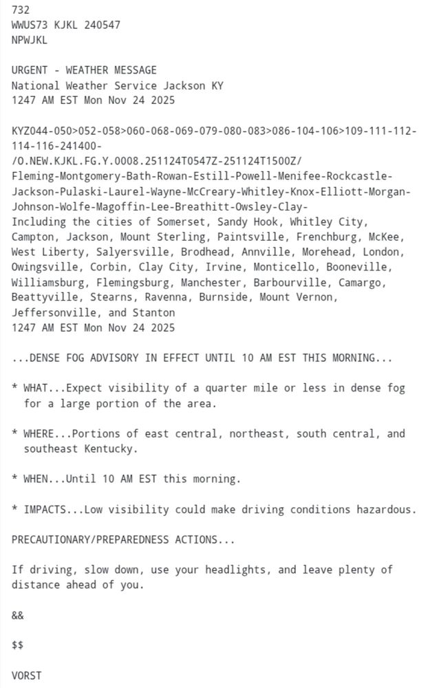

November 24, 2025 at 12:47 PM
@jkl.nws-bot.us #JKL issued a Dense Fog Advisory (FG) 12:47 AM EST on 24 Nov until 10:00 AM EST for portions of Eastern Kentucky. Details 👉 at mesonet.agron.iastate.edu/vtec/?year=2... #ekywx #kywx
Here is the extended forecast for the next 7 days from the NWS Office in Jackson KY for @cocorahskyjc6.bsky.social. Get the hyperlocal forecast for your specific location on the NOAA Weather app at the #GooglePlay store. So, what's the weather going to be like in your neighborhood? #ekywx #kywx

November 24, 2025 at 2:45 AM
Here is the extended forecast for the next 7 days from the NWS Office in Jackson KY for @cocorahskyjc6.bsky.social. Get the hyperlocal forecast for your specific location on the NOAA Weather app at the #GooglePlay store. So, what's the weather going to be like in your neighborhood? #ekywx #kywx
Here is the hyperlocal forecast for the next 36 hours from the NWS Office in Jackson KY for @cocorahskyjc6.bsky.social. Get the hyperlocal forecast for your specific location on the NOAA Weather app at the #GooglePlay store. So, what's the weather going to be like in your neighborhood? #ekywx #kywx

November 24, 2025 at 2:44 AM
Here is the hyperlocal forecast for the next 36 hours from the NWS Office in Jackson KY for @cocorahskyjc6.bsky.social. Get the hyperlocal forecast for your specific location on the NOAA Weather app at the #GooglePlay store. So, what's the weather going to be like in your neighborhood? #ekywx #kywx
@jkl.nws-bot.us #JKL issued a Special Weather Statement (SPS) for Areas of Dense Fog Expected Tonight and Monday Morning across Eastern Kentucky. Details 👉 mesonet.agron.iastate.edu/wx/afos/p.ph... #ekywx #kywx


November 24, 2025 at 2:32 AM
@jkl.nws-bot.us #JKL issued a Special Weather Statement (SPS) for Areas of Dense Fog Expected Tonight and Monday Morning across Eastern Kentucky. Details 👉 mesonet.agron.iastate.edu/wx/afos/p.ph... #ekywx #kywx
Dense Fog Advisory overnight into Mon morning.
- Visibility of a quarter of a mile or less
- Use low-beams when traveling
- slow down and give plenty of distance
For more info visit: weather.gov/louisville #KYwx #INwx
- Visibility of a quarter of a mile or less
- Use low-beams when traveling
- slow down and give plenty of distance
For more info visit: weather.gov/louisville #KYwx #INwx

November 24, 2025 at 2:30 AM
Dense Fog Advisory overnight into Mon morning.
- Visibility of a quarter of a mile or less
- Use low-beams when traveling
- slow down and give plenty of distance
For more info visit: weather.gov/louisville #KYwx #INwx
- Visibility of a quarter of a mile or less
- Use low-beams when traveling
- slow down and give plenty of distance
For more info visit: weather.gov/louisville #KYwx #INwx
23 Nov 2025 daily observation report using a #CoCoRaHS-approved #CLIMALYTIC Tropo Rain/Snow Gauge along with a #Logia 7-in-1 #WiFi #PWS (Model LOWSC710SWB).
This location reports #wxdata 24/7/365 to #weathercloud & at wunderground.com/dashboard/pws/KKYMCKEE41 #CWOP #ShareYourWeather #ekywx #kywx
This location reports #wxdata 24/7/365 to #weathercloud & at wunderground.com/dashboard/pws/KKYMCKEE41 #CWOP #ShareYourWeather #ekywx #kywx


November 23, 2025 at 3:41 PM
23 Nov 2025 daily observation report using a #CoCoRaHS-approved #CLIMALYTIC Tropo Rain/Snow Gauge along with a #Logia 7-in-1 #WiFi #PWS (Model LOWSC710SWB).
This location reports #wxdata 24/7/365 to #weathercloud & at wunderground.com/dashboard/pws/KKYMCKEE41 #CWOP #ShareYourWeather #ekywx #kywx
This location reports #wxdata 24/7/365 to #weathercloud & at wunderground.com/dashboard/pws/KKYMCKEE41 #CWOP #ShareYourWeather #ekywx #kywx
@sdf.nws-bot.us #LMK issued Dense Fog Advisory (FG) at 11:50 PM EST on 22 Nov for Central Kentucky and a portion of Southern Indiana until 10:00 AM EST on 23 Nov. See 👉 mesonet.agron.iastate.edu/vtec/?year=2... for details. #kywx #inwx


November 23, 2025 at 1:53 PM
@sdf.nws-bot.us #LMK issued Dense Fog Advisory (FG) at 11:50 PM EST on 22 Nov for Central Kentucky and a portion of Southern Indiana until 10:00 AM EST on 23 Nov. See 👉 mesonet.agron.iastate.edu/vtec/?year=2... for details. #kywx #inwx
@jkl.nws-bot.us #JKL at 11:46 PM EST on 22 Nov issued a Dense Fog Advisory (FG) until 10:00 AM EST on 23 Nov. See 👉 mesonet.agron.iastate.edu/vtec/?year=2... for details. #ekywx #kywx


November 23, 2025 at 1:45 PM
@jkl.nws-bot.us #JKL at 11:46 PM EST on 22 Nov issued a Dense Fog Advisory (FG) until 10:00 AM EST on 23 Nov. See 👉 mesonet.agron.iastate.edu/vtec/?year=2... for details. #ekywx #kywx
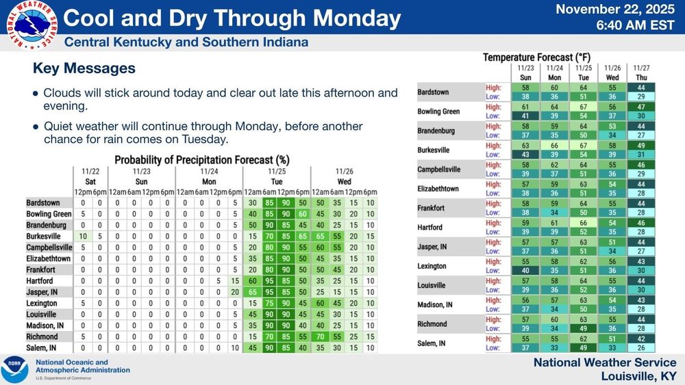
Dense fog is present over Central KY and Southern IN this morning and will likely not thin out until mid morning. Use caution while driving. Pleasant weather will remain through Monday, before widespread showers and a few storms move in on Monday night. Cooler air is expected for the holidays. #kywx

November 23, 2025 at 1:39 PM
Dense fog is present over Central KY and Southern IN this morning and will likely not thin out until mid morning. Use caution while driving. Pleasant weather will remain through Monday, before widespread showers and a few storms move in on Monday night. Cooler air is expected for the holidays. #kywx
22 Nov 2025 Climate Summary for #nwsjacksonky, #kymesonet, #DanielBooneNF, & other interests.
High: 63.6°F
Low: 43.3°F
Pcpn.: 0.20" (M)
Snow: 0.0"
Snow Depth: 0.0"
More #wxdata may be found 24/7/365 at wunderground.com/dashboard/pw... #ekywx #kywx #CWOP #ShareYourWeather
High: 63.6°F
Low: 43.3°F
Pcpn.: 0.20" (M)
Snow: 0.0"
Snow Depth: 0.0"
More #wxdata may be found 24/7/365 at wunderground.com/dashboard/pw... #ekywx #kywx #CWOP #ShareYourWeather
Personal Weather Station Dashboard | Weather Underground
Weather Underground provides local & long-range weather forecasts, weather reports, maps & tropical weather conditions for locations worldwide.
wunderground.com
November 23, 2025 at 10:56 AM
22 Nov 2025 Climate Summary for #nwsjacksonky, #kymesonet, #DanielBooneNF, & other interests.
High: 63.6°F
Low: 43.3°F
Pcpn.: 0.20" (M)
Snow: 0.0"
Snow Depth: 0.0"
More #wxdata may be found 24/7/365 at wunderground.com/dashboard/pw... #ekywx #kywx #CWOP #ShareYourWeather
High: 63.6°F
Low: 43.3°F
Pcpn.: 0.20" (M)
Snow: 0.0"
Snow Depth: 0.0"
More #wxdata may be found 24/7/365 at wunderground.com/dashboard/pw... #ekywx #kywx #CWOP #ShareYourWeather
22 Nov 2025 daily observation report using a #CoCoRaHS-approved #CLIMALYTIC Tropo Rain/Snow Gauge along with a #Logia 7-in-1 #WiFi #PWS (Model LOWSC710SWB).
This location reports #wxdata 24/7/365 to #weathercloud & at wunderground.com/dashboard/pws/KKYMCKEE41 #CWOP #ShareYourWeather #ekywx #kywx
This location reports #wxdata 24/7/365 to #weathercloud & at wunderground.com/dashboard/pws/KKYMCKEE41 #CWOP #ShareYourWeather #ekywx #kywx


November 22, 2025 at 12:29 PM
22 Nov 2025 daily observation report using a #CoCoRaHS-approved #CLIMALYTIC Tropo Rain/Snow Gauge along with a #Logia 7-in-1 #WiFi #PWS (Model LOWSC710SWB).
This location reports #wxdata 24/7/365 to #weathercloud & at wunderground.com/dashboard/pws/KKYMCKEE41 #CWOP #ShareYourWeather #ekywx #kywx
This location reports #wxdata 24/7/365 to #weathercloud & at wunderground.com/dashboard/pws/KKYMCKEE41 #CWOP #ShareYourWeather #ekywx #kywx
@sdf.nws-bot.us #LMK at 3:04 AM EST on 22 Nov issued a Hazardous Weather Outlook (HWO) for Central Kentucky and Southern Indiana. Details 👉 at mesonet.agron.iastate.edu/wx/afos/p.ph... #kywx #inwx

November 22, 2025 at 12:28 PM
@sdf.nws-bot.us #LMK at 3:04 AM EST on 22 Nov issued a Hazardous Weather Outlook (HWO) for Central Kentucky and Southern Indiana. Details 👉 at mesonet.agron.iastate.edu/wx/afos/p.ph... #kywx #inwx
@jkl.nws-bot.us #JKL issued a Hazardous Weather Outlook (HWO) at 2:04 AM EST on 22 Nov for Eastern Kentucky. Details 👉 at mesonet.agron.iastate.edu/wx/afos/p.ph... #ekywx #kywx

November 22, 2025 at 12:25 PM
@jkl.nws-bot.us #JKL issued a Hazardous Weather Outlook (HWO) at 2:04 AM EST on 22 Nov for Eastern Kentucky. Details 👉 at mesonet.agron.iastate.edu/wx/afos/p.ph... #ekywx #kywx
@jkl.nws-bot.us #JKL issued a Hazardous Weather Outlook (HWO) at 10:43 PM EST on 21 Nov for Eastern Kentucky. Details 👉 at mesonet.agron.iastate.edu/wx/afos/p.ph... #ekywx #kywx

November 22, 2025 at 5:27 AM
@jkl.nws-bot.us #JKL issued a Hazardous Weather Outlook (HWO) at 10:43 PM EST on 21 Nov for Eastern Kentucky. Details 👉 at mesonet.agron.iastate.edu/wx/afos/p.ph... #ekywx #kywx
21 Nov 2025 Climate Summary near the #HorseLickCreekBioreserveArea, #JacksonCountyKy in the #DanielBooneNF
High: 63.6°F
Low: 52.8°F
Precip: 0.24" (M)
Snow: 0.0"
Snow Depth: 0.0"
More #wxdata may be found 24/7/365 at wunderground.com/dashboard/pws/KKYMCKEE41 #ekywx #kywx #CWOP #ShareYourWeather
High: 63.6°F
Low: 52.8°F
Precip: 0.24" (M)
Snow: 0.0"
Snow Depth: 0.0"
More #wxdata may be found 24/7/365 at wunderground.com/dashboard/pws/KKYMCKEE41 #ekywx #kywx #CWOP #ShareYourWeather
Personal Weather Station Dashboard | Weather Underground
Weather Underground provides local & long-range weather forecasts, weather reports, maps & tropical weather conditions for locations worldwide.
wunderground.com
November 22, 2025 at 5:23 AM
21 Nov 2025 Climate Summary near the #HorseLickCreekBioreserveArea, #JacksonCountyKy in the #DanielBooneNF
High: 63.6°F
Low: 52.8°F
Precip: 0.24" (M)
Snow: 0.0"
Snow Depth: 0.0"
More #wxdata may be found 24/7/365 at wunderground.com/dashboard/pws/KKYMCKEE41 #ekywx #kywx #CWOP #ShareYourWeather
High: 63.6°F
Low: 52.8°F
Precip: 0.24" (M)
Snow: 0.0"
Snow Depth: 0.0"
More #wxdata may be found 24/7/365 at wunderground.com/dashboard/pws/KKYMCKEE41 #ekywx #kywx #CWOP #ShareYourWeather
21 Nov 2025 daily observation report using a #CoCoRaHS-approved #CLIMALYTIC Tropo Rain/Snow Gauge along with a #Logia 7-in-1 #WiFi #PWS (Model LOWSC710SWB).
This location reports #wxdata 24/7/365 to #weathercloud & at wunderground.com/dashboard/pws/KKYMCKEE41 #CWOP #ShareYourWeather #ekywx #kywx
This location reports #wxdata 24/7/365 to #weathercloud & at wunderground.com/dashboard/pws/KKYMCKEE41 #CWOP #ShareYourWeather #ekywx #kywx


November 21, 2025 at 8:22 PM
21 Nov 2025 daily observation report using a #CoCoRaHS-approved #CLIMALYTIC Tropo Rain/Snow Gauge along with a #Logia 7-in-1 #WiFi #PWS (Model LOWSC710SWB).
This location reports #wxdata 24/7/365 to #weathercloud & at wunderground.com/dashboard/pws/KKYMCKEE41 #CWOP #ShareYourWeather #ekywx #kywx
This location reports #wxdata 24/7/365 to #weathercloud & at wunderground.com/dashboard/pws/KKYMCKEE41 #CWOP #ShareYourWeather #ekywx #kywx
20 Nov 2025 Climate Summary for #nwsjacksonky, #kymesonet, #DanielBooneNF, & other interests.
High: 61.8°F
Low: 49.4°F
Pcpn.: 0.09" (M)
Snow: 0.0"
Snow Depth: 0.0"
More #wxdata may be found 24/7/365 at wunderground.com/dashboard/pw... #ekywx #kywx #CWOP #ShareYourWeather
High: 61.8°F
Low: 49.4°F
Pcpn.: 0.09" (M)
Snow: 0.0"
Snow Depth: 0.0"
More #wxdata may be found 24/7/365 at wunderground.com/dashboard/pw... #ekywx #kywx #CWOP #ShareYourWeather
Personal Weather Station Dashboard | Weather Underground
Weather Underground provides local & long-range weather forecasts, weather reports, maps & tropical weather conditions for locations worldwide.
wunderground.com
November 21, 2025 at 5:41 AM
20 Nov 2025 Climate Summary for #nwsjacksonky, #kymesonet, #DanielBooneNF, & other interests.
High: 61.8°F
Low: 49.4°F
Pcpn.: 0.09" (M)
Snow: 0.0"
Snow Depth: 0.0"
More #wxdata may be found 24/7/365 at wunderground.com/dashboard/pw... #ekywx #kywx #CWOP #ShareYourWeather
High: 61.8°F
Low: 49.4°F
Pcpn.: 0.09" (M)
Snow: 0.0"
Snow Depth: 0.0"
More #wxdata may be found 24/7/365 at wunderground.com/dashboard/pw... #ekywx #kywx #CWOP #ShareYourWeather
Clouds will linger for much of the daytime hours on Thursday across East Kentucky with rain chances spreading from SW->NE overnight. Heavier rain, and perhaps a few thunderstorms, will dominate Friday's forecast before a cold front sweeps through on Saturday. Sunday looks drier though! #ekywx #kywx

November 20, 2025 at 8:44 PM
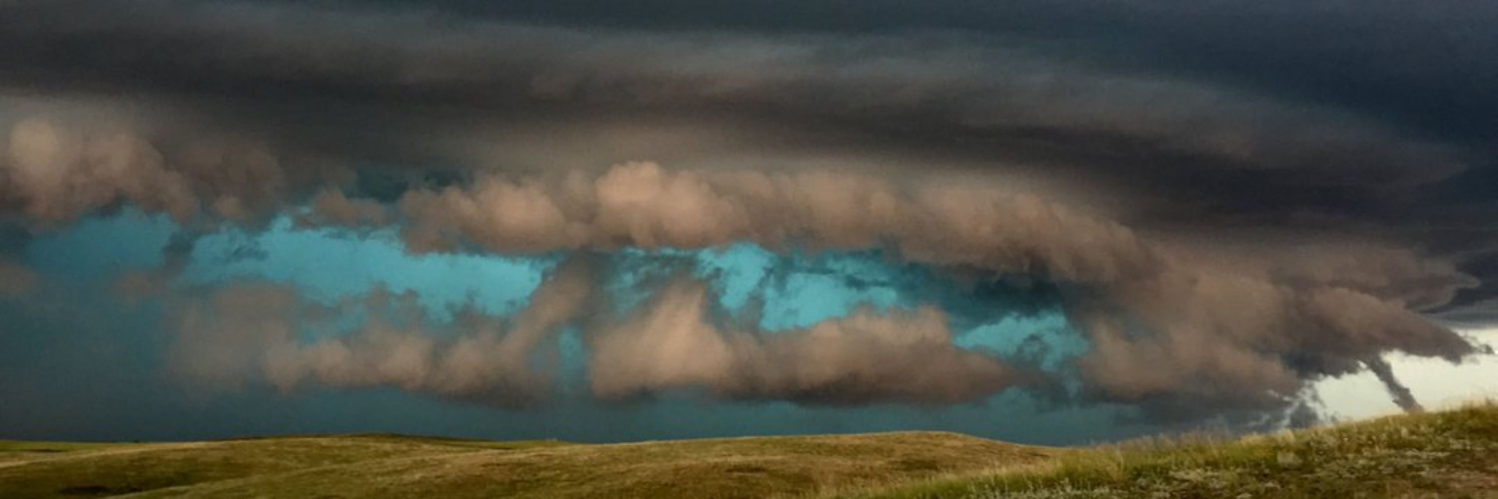
For 50 years, #NOAA’s GOES satellites have been our “eyes in the sky,” tracking storms, wildfires, solar activity and more to help keep us safe. 🛰️
To celebrate, we’re looking back at ten unforgettable moments they’ve captured. #GOES50
bit.ly/48oajXX
To celebrate, we’re looking back at ten unforgettable moments they’ve captured. #GOES50
bit.ly/48oajXX

10 Memorable Images Captured by NOAA’s GOES Satellites
To mark 50 years of GOES in orbit, NOAA is looking back at ten notable events captured by these groundbreaking satellites.
bit.ly
November 20, 2025 at 8:39 PM
For 50 years, #NOAA’s GOES satellites have been our “eyes in the sky,” tracking storms, wildfires, solar activity and more to help keep us safe. 🛰️
To celebrate, we’re looking back at ten unforgettable moments they’ve captured. #GOES50
bit.ly/48oajXX
To celebrate, we’re looking back at ten unforgettable moments they’ve captured. #GOES50
bit.ly/48oajXX
Here is the extended forecast for the next 7 days from the NWS Office in Jackson KY for @cocorahskyjc6.bsky.social. Get the hyperlocal forecast for your specific location on the NOAA Weather app at the #GooglePlay store. So, what's the weather going to be like in your neighborhood? #ekywx #kywx

November 20, 2025 at 12:54 PM
Here is the extended forecast for the next 7 days from the NWS Office in Jackson KY for @cocorahskyjc6.bsky.social. Get the hyperlocal forecast for your specific location on the NOAA Weather app at the #GooglePlay store. So, what's the weather going to be like in your neighborhood? #ekywx #kywx
Here is the hyperlocal forecast for the next 2 days from the NWS Office in Jackson KY for @cocorahskyjc6.bsky.social. Get the hyperlocal forecast for your specific location on the NOAA Weather app at the #GooglePlay store. So, what's the weather going to be like in your neighborhood? #ekywx #kywx

November 20, 2025 at 12:54 PM
Here is the hyperlocal forecast for the next 2 days from the NWS Office in Jackson KY for @cocorahskyjc6.bsky.social. Get the hyperlocal forecast for your specific location on the NOAA Weather app at the #GooglePlay store. So, what's the weather going to be like in your neighborhood? #ekywx #kywx