


David Blanchard
@davidblanchard.bsky.social
Atmospheric Scientist, Ph.D., CCM. Chased by storms since 1981. Trail running, mountain biking, skiing. Astro, weather, and landscape photographer.
dblanchard.net/blog/
dblanchard.net/blog/
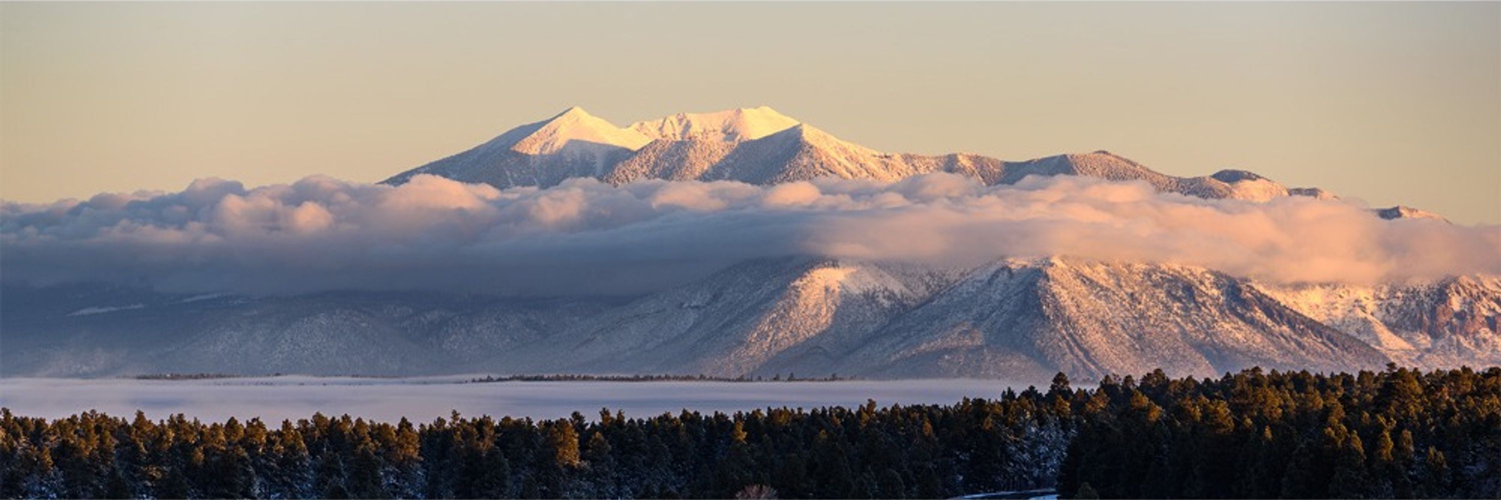
Clear skies overnight allowed some shallow fog to develop in the Mormon Lake Basin. The San Francisco Peaks loom in the distance.
#landscape 📷 #fog
#landscape 📷 #fog

November 25, 2025 at 1:02 AM
Clear skies overnight allowed some shallow fog to develop in the Mormon Lake Basin. The San Francisco Peaks loom in the distance.
#landscape 📷 #fog
#landscape 📷 #fog
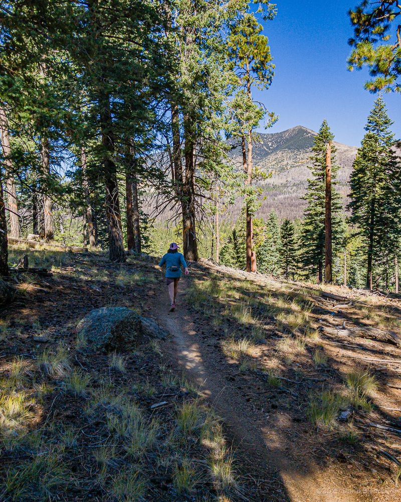
Today's run took us down the Arizona Trail into Picture Canyon Natural and Cultural Preserve -- and then returned via the Tom Moody Trail. The snow has already melted and trail was a perfect dampness.
#trailrunning #ArizonaTrail #landscape 📷
#trailrunning #ArizonaTrail #landscape 📷


November 22, 2025 at 10:25 PM
Today's run took us down the Arizona Trail into Picture Canyon Natural and Cultural Preserve -- and then returned via the Tom Moody Trail. The snow has already melted and trail was a perfect dampness.
#trailrunning #ArizonaTrail #landscape 📷
#trailrunning #ArizonaTrail #landscape 📷

Testing the Tamron SP 35mm f/1.4 Di USD on the Milky Way. Vega is bottom center; North America Nebula is upper right.
Nikon D850, 35mm, f/1.4, ISO 200, 10x120 seconds. Stacked in Siril with Star Reduction.
Great lens!
#astrophotography #Nikon #Tamron #siril
Nikon D850, 35mm, f/1.4, ISO 200, 10x120 seconds. Stacked in Siril with Star Reduction.
Great lens!
#astrophotography #Nikon #Tamron #siril

November 18, 2025 at 5:28 PM
Testing the Tamron SP 35mm f/1.4 Di USD on the Milky Way. Vega is bottom center; North America Nebula is upper right.
Nikon D850, 35mm, f/1.4, ISO 200, 10x120 seconds. Stacked in Siril with Star Reduction.
Great lens!
#astrophotography #Nikon #Tamron #siril
Nikon D850, 35mm, f/1.4, ISO 200, 10x120 seconds. Stacked in Siril with Star Reduction.
Great lens!
#astrophotography #Nikon #Tamron #siril
Three of us ran the recently realigned Upper Oldham Trail in the Mount Elden–Dry Lakes (MEDL) area on Tuesday. About 7.1 miles round trip and 1350 feet vertical. Amazing trail and we will be back!
#landscape 📷 #trailrunning
#landscape 📷 #trailrunning


November 14, 2025 at 7:34 PM
Three of us ran the recently realigned Upper Oldham Trail in the Mount Elden–Dry Lakes (MEDL) area on Tuesday. About 7.1 miles round trip and 1350 feet vertical. Amazing trail and we will be back!
#landscape 📷 #trailrunning
#landscape 📷 #trailrunning
Another image from last night's aurora showing the silhouette of a heron wading in the shallow water of the lake. Shot with a 12mm fisheye lens--hence the curvature (2158 MST; 0458 UTC)
#astrophotography #landscape 📷 #aurora
#astrophotography #landscape 📷 #aurora

November 12, 2025 at 9:16 PM
Another image from last night's aurora showing the silhouette of a heron wading in the shallow water of the lake. Shot with a 12mm fisheye lens--hence the curvature (2158 MST; 0458 UTC)
#astrophotography #landscape 📷 #aurora
#astrophotography #landscape 📷 #aurora
Time-lapse video of last nights aurora from 0248–0526 UTC (1948–2226 MST) with peak sub-storm activity from 0430–0455 UTC (2130–2155MST).
Nikon D850, 12mm fish eye, f/4, ISO3200, 15 seconds per image.
#astrophotography #aurora #landscape 📷
Nikon D850, 12mm fish eye, f/4, ISO3200, 15 seconds per image.
#astrophotography #aurora #landscape 📷
November 12, 2025 at 7:07 PM
Time-lapse video of last nights aurora from 0248–0526 UTC (1948–2226 MST) with peak sub-storm activity from 0430–0455 UTC (2130–2155MST).
Nikon D850, 12mm fish eye, f/4, ISO3200, 15 seconds per image.
#astrophotography #aurora #landscape 📷
Nikon D850, 12mm fish eye, f/4, ISO3200, 15 seconds per image.
#astrophotography #aurora #landscape 📷
Brilliant substorm erupted around 0430-0450 UTC producing numerous pillars -- all easily visible naked eye from near Flagstaff.
Nikon D850, 12mm fisheye, f/4, ISO 3200, 15 seconds.
#landscape 📷 #aurora
Nikon D850, 12mm fisheye, f/4, ISO 3200, 15 seconds.
#landscape 📷 #aurora

November 12, 2025 at 7:18 AM
Brilliant substorm erupted around 0430-0450 UTC producing numerous pillars -- all easily visible naked eye from near Flagstaff.
Nikon D850, 12mm fisheye, f/4, ISO 3200, 15 seconds.
#landscape 📷 #aurora
Nikon D850, 12mm fisheye, f/4, ISO 3200, 15 seconds.
#landscape 📷 #aurora
November 12, 2025 at 4:43 AM
Comet C/2025 A6 (Lemmon) on Sunday evening.
Nikon D850, 180mm, f/4, ISO 200, 120 seconds; single image.
Second image is a black+white negative which shows more structure in the tail.
#astrophotography 📷 #comet #nikonusa
Nikon D850, 180mm, f/4, ISO 200, 120 seconds; single image.
Second image is a black+white negative which shows more structure in the tail.
#astrophotography 📷 #comet #nikonusa


November 11, 2025 at 1:20 AM
Comet C/2025 A6 (Lemmon) on Sunday evening.
Nikon D850, 180mm, f/4, ISO 200, 120 seconds; single image.
Second image is a black+white negative which shows more structure in the tail.
#astrophotography 📷 #comet #nikonusa
Nikon D850, 180mm, f/4, ISO 200, 120 seconds; single image.
Second image is a black+white negative which shows more structure in the tail.
#astrophotography 📷 #comet #nikonusa
A mountain bike ride at Fort Tuthill in Flagstaff means we get to travel through the Cosmic Ray Tunnel at Sheep Crossing Trail. Yeah, complicated name but they wanted to honor both a great person and the historical nature of the underpass.
#mountainbikeing #flagstaff #arizona
#mountainbikeing #flagstaff #arizona


November 9, 2025 at 3:30 AM
A mountain bike ride at Fort Tuthill in Flagstaff means we get to travel through the Cosmic Ray Tunnel at Sheep Crossing Trail. Yeah, complicated name but they wanted to honor both a great person and the historical nature of the underpass.
#mountainbikeing #flagstaff #arizona
#mountainbikeing #flagstaff #arizona
Rx burns meant we had to change our running plans at the last moment. Instead of Fort Valley trails (smokey) we did Rocky Ridge, Middle Oldham, and a portion of Upper Oldham. The recently realigned Upper Oldham is really nice!
#landscape 📷 #trailrunning
#landscape 📷 #trailrunning

November 6, 2025 at 11:30 PM
Rx burns meant we had to change our running plans at the last moment. Instead of Fort Valley trails (smokey) we did Rocky Ridge, Middle Oldham, and a portion of Upper Oldham. The recently realigned Upper Oldham is really nice!
#landscape 📷 #trailrunning
#landscape 📷 #trailrunning
Autumn colors have not yet hit their peak in Oak Creek canyon and side canyons. Another week?
#landscape 📷
#landscape 📷


November 6, 2025 at 12:41 AM
Autumn colors have not yet hit their peak in Oak Creek canyon and side canyons. Another week?
#landscape 📷
#landscape 📷
Was looking for autumn color in Oak Creek Canyon but also found many wildflowers.
#landscape 📷 #wildflowers
#landscape 📷 #wildflowers


November 6, 2025 at 12:35 AM
Was looking for autumn color in Oak Creek Canyon but also found many wildflowers.
#landscape 📷 #wildflowers
#landscape 📷 #wildflowers
Another image from Comet C/2025 A6 (Lemmon) -- this time using the zoom lens at 500mm. Focus is just a bit soft -- operator error, of course.
Nikon D850, 500mm, ƒ/5.6, ISO 800, 30 seconds.
Bonus: gibbous waxing Moon.
#astrophotography
Nikon D850, 500mm, ƒ/5.6, ISO 800, 30 seconds.
Bonus: gibbous waxing Moon.
#astrophotography


October 31, 2025 at 10:12 PM
Another image from Comet C/2025 A6 (Lemmon) -- this time using the zoom lens at 500mm. Focus is just a bit soft -- operator error, of course.
Nikon D850, 500mm, ƒ/5.6, ISO 800, 30 seconds.
Bonus: gibbous waxing Moon.
#astrophotography
Nikon D850, 500mm, ƒ/5.6, ISO 800, 30 seconds.
Bonus: gibbous waxing Moon.
#astrophotography
Sometimes all you need to do is go out on the back porch to see some wonderful fall colors. The trees in the neighborhood are at peak color right now.
Sony RX10m4, 600mm (equivalent).
#landscape 📷 #aspen #fallfoliage
Sony RX10m4, 600mm (equivalent).
#landscape 📷 #aspen #fallfoliage

October 31, 2025 at 6:03 PM
Sometimes all you need to do is go out on the back porch to see some wonderful fall colors. The trees in the neighborhood are at peak color right now.
Sony RX10m4, 600mm (equivalent).
#landscape 📷 #aspen #fallfoliage
Sony RX10m4, 600mm (equivalent).
#landscape 📷 #aspen #fallfoliage
Another trail run on Thursday in the Dry Lakes area north of Flagstaff. A few stands of aspen continue to show great color.
#trailrunning #landscape 📷
#trailrunning #landscape 📷


October 31, 2025 at 6:00 PM
Another trail run on Thursday in the Dry Lakes area north of Flagstaff. A few stands of aspen continue to show great color.
#trailrunning #landscape 📷
#trailrunning #landscape 📷
Did a trail run on some of the newer trails in the Dry Lake Hills north of Flagstaff using Broadside -- Abalone -- Swell -- Brookbank -- Lunar Tide -- Swell -- Schultz Creek. Got to see a stand of colorful aspens along the way. Breezy but mild temperatures.
#trailrunning #landscape 📷
#trailrunning #landscape 📷

October 28, 2025 at 11:54 PM
Did a trail run on some of the newer trails in the Dry Lake Hills north of Flagstaff using Broadside -- Abalone -- Swell -- Brookbank -- Lunar Tide -- Swell -- Schultz Creek. Got to see a stand of colorful aspens along the way. Breezy but mild temperatures.
#trailrunning #landscape 📷
#trailrunning #landscape 📷
Comet C/2025 A6 (Lemmon) at 1858 MST 26 October 2025 from northern Arizona.
Nikon D850, Nikkor 180mm AI-s, f/4, ISO 200, 120 seconds.
#astrophotography
Nikon D850, Nikkor 180mm AI-s, f/4, ISO 200, 120 seconds.
#astrophotography

October 28, 2025 at 12:42 AM
Comet C/2025 A6 (Lemmon) at 1858 MST 26 October 2025 from northern Arizona.
Nikon D850, Nikkor 180mm AI-s, f/4, ISO 200, 120 seconds.
#astrophotography
Nikon D850, Nikkor 180mm AI-s, f/4, ISO 200, 120 seconds.
#astrophotography
Motion of Comet C/2025 A6 (Lemmon) over a period of ~1 hour.
Nikon D850, Nikkon 180mm AI-S, f/4, ISO 200, 30x120 seconds.
#astrophotography
Nikon D850, Nikkon 180mm AI-S, f/4, ISO 200, 30x120 seconds.
#astrophotography
October 27, 2025 at 5:13 AM
Motion of Comet C/2025 A6 (Lemmon) over a period of ~1 hour.
Nikon D850, Nikkon 180mm AI-S, f/4, ISO 200, 30x120 seconds.
#astrophotography
Nikon D850, Nikkon 180mm AI-S, f/4, ISO 200, 30x120 seconds.
#astrophotography

October 26, 2025 at 1:28 AM
Comet C/2025 A6 (Lemmon) shortly after the end of astro twilight. As has been typical, the wide angle view picks up a lot of green airglow near the horizon.
This is a composite of two images: one tracking the stars/comet and the other untracked for the foreground.
#astrophotography #landscape 📷
This is a composite of two images: one tracking the stars/comet and the other untracked for the foreground.
#astrophotography #landscape 📷

October 25, 2025 at 4:55 AM
Comet C/2025 A6 (Lemmon) shortly after the end of astro twilight. As has been typical, the wide angle view picks up a lot of green airglow near the horizon.
This is a composite of two images: one tracking the stars/comet and the other untracked for the foreground.
#astrophotography #landscape 📷
This is a composite of two images: one tracking the stars/comet and the other untracked for the foreground.
#astrophotography #landscape 📷
The Pleiades and Uranus with bands of green airglow: 18 October 2025.
Nikon D850, 85mm, f/4, ISO 200, 120 seconds.
#astrophotography
Nikon D850, 85mm, f/4, ISO 200, 120 seconds.
#astrophotography

October 22, 2025 at 6:17 PM
The Pleiades and Uranus with bands of green airglow: 18 October 2025.
Nikon D850, 85mm, f/4, ISO 200, 120 seconds.
#astrophotography
Nikon D850, 85mm, f/4, ISO 200, 120 seconds.
#astrophotography
Two comets in one evening (20 October 2025):
C/2025 A6 (Lemmon)
C/2025 R2 (SWAN)
Nikon D850, Tamron 35mm, f/2.8, ISO 200.
Additional details in Alt Text.
#astrophotography #landscape 📷
C/2025 A6 (Lemmon)
C/2025 R2 (SWAN)
Nikon D850, Tamron 35mm, f/2.8, ISO 200.
Additional details in Alt Text.
#astrophotography #landscape 📷


October 21, 2025 at 11:09 PM
Two comets in one evening (20 October 2025):
C/2025 A6 (Lemmon)
C/2025 R2 (SWAN)
Nikon D850, Tamron 35mm, f/2.8, ISO 200.
Additional details in Alt Text.
#astrophotography #landscape 📷
C/2025 A6 (Lemmon)
C/2025 R2 (SWAN)
Nikon D850, Tamron 35mm, f/2.8, ISO 200.
Additional details in Alt Text.
#astrophotography #landscape 📷
Comet C/2025 A6 (Lemmon).
Nikon D850, Nikkor 180mm AI-S, f/4, ISO 200, 120 sec.
The original had numerous satellite tracks so I used the Remove tool in Photoshop and had it remove "wires and cables" and it worked--but did take out a few stars as well.
#astrophotography
Nikon D850, Nikkor 180mm AI-S, f/4, ISO 200, 120 sec.
The original had numerous satellite tracks so I used the Remove tool in Photoshop and had it remove "wires and cables" and it worked--but did take out a few stars as well.
#astrophotography

October 21, 2025 at 12:39 AM
Comet C/2025 A6 (Lemmon).
Nikon D850, Nikkor 180mm AI-S, f/4, ISO 200, 120 sec.
The original had numerous satellite tracks so I used the Remove tool in Photoshop and had it remove "wires and cables" and it worked--but did take out a few stars as well.
#astrophotography
Nikon D850, Nikkor 180mm AI-S, f/4, ISO 200, 120 sec.
The original had numerous satellite tracks so I used the Remove tool in Photoshop and had it remove "wires and cables" and it worked--but did take out a few stars as well.
#astrophotography