


Fumihiko Ikegami
@fikgm.bsky.social
Earth Science Watcher in Japan. Master of Geology and None. I am myself, not employers.
Pinned

Metallic (specular) shading best matches for a cinder cone.

February 6, 2026 at 1:50 PM
Metallic (specular) shading best matches for a cinder cone.


February 5, 2026 at 11:42 AM
Very interesting paper from China. They drilled two 10-km holes in 2025 and found hydrocarbon from that depth.
Zhu & Huang (2026) Comm. Earth Environ.
Ultradeep drilling beyond 10 km revealing new insights into Earth systems and resources
www.nature.com/articles/s43...
Zhu & Huang (2026) Comm. Earth Environ.
Ultradeep drilling beyond 10 km revealing new insights into Earth systems and resources
www.nature.com/articles/s43...

Ultradeep drilling beyond 10 km revealing new insights into Earth systems and resources - Communications Earth & Environment
Hydrocarbons can persist and migrate far deeper than previously assumed and may coexist with natural hydrogen, geothermal fluids, and metal-rich brines, according to a synthesis of geochemical and pet...
www.nature.com
February 4, 2026 at 12:57 PM
Very interesting paper from China. They drilled two 10-km holes in 2025 and found hydrocarbon from that depth.
Zhu & Huang (2026) Comm. Earth Environ.
Ultradeep drilling beyond 10 km revealing new insights into Earth systems and resources
www.nature.com/articles/s43...
Zhu & Huang (2026) Comm. Earth Environ.
Ultradeep drilling beyond 10 km revealing new insights into Earth systems and resources
www.nature.com/articles/s43...
Diagram: Structure of the Deep Earth - by Fumihiko Ikegami
ikegami.substack.com/p/diagram-st...
The figure I've posted before + A bit of additional notes.
ikegami.substack.com/p/diagram-st...
The figure I've posted before + A bit of additional notes.

February 4, 2026 at 5:18 AM
Diagram: Structure of the Deep Earth - by Fumihiko Ikegami
ikegami.substack.com/p/diagram-st...
The figure I've posted before + A bit of additional notes.
ikegami.substack.com/p/diagram-st...
The figure I've posted before + A bit of additional notes.
geoign/Geoscience_Figures: My original scientific figures for Geosciences github.com/geoign/Geosc...
Adobe Illustrator .ai file is also available for editing. CC BY-NC 4.0 License.
Adobe Illustrator .ai file is also available for editing. CC BY-NC 4.0 License.
February 1, 2026 at 3:54 AM
geoign/Geoscience_Figures: My original scientific figures for Geosciences github.com/geoign/Geosc...
Adobe Illustrator .ai file is also available for editing. CC BY-NC 4.0 License.
Adobe Illustrator .ai file is also available for editing. CC BY-NC 4.0 License.
Some impressive eruption photos (between 2004-2025) from Kirishima Geopark
www.facebook.com/media/set?va...
www.facebook.com/media/set?va...

January 26, 2026 at 3:19 PM
Some impressive eruption photos (between 2004-2025) from Kirishima Geopark
www.facebook.com/media/set?va...
www.facebook.com/media/set?va...
English version! The colors of the mantle are based on the actual mineral colors (except lithospheric mantle). If you have any idea or suggestion, let me know!


January 26, 2026 at 9:41 AM
English version! The colors of the mantle are based on the actual mineral colors (except lithospheric mantle). If you have any idea or suggestion, let me know!
Holiday drawing. (Don't worry. I'll create the English version too.)


January 25, 2026 at 12:38 PM
Holiday drawing. (Don't worry. I'll create the English version too.)
JMA has raised the alert level for Yakedake volcano in Japan due to the increased seismicity as well as the tilt change suggesting an edifice inflation. (Google Translated Image attached)
www.jma.go.jp/bosai/volcan...
www.jma.go.jp/bosai/volcan...

January 24, 2026 at 10:43 PM
JMA has raised the alert level for Yakedake volcano in Japan due to the increased seismicity as well as the tilt change suggesting an edifice inflation. (Google Translated Image attached)
www.jma.go.jp/bosai/volcan...
www.jma.go.jp/bosai/volcan...
Where Volcanoes Form on Earth?
open.substack.com/pub/ikegami/...
Many textbooks are still stuck at the level of understanding from the formative era of plate tectonics—over 50 years ago. In this article, I organize where on Earth volcanoes occur.
open.substack.com/pub/ikegami/...
Many textbooks are still stuck at the level of understanding from the formative era of plate tectonics—over 50 years ago. In this article, I organize where on Earth volcanoes occur.

January 24, 2026 at 2:53 AM
Where Volcanoes Form on Earth?
open.substack.com/pub/ikegami/...
Many textbooks are still stuck at the level of understanding from the formative era of plate tectonics—over 50 years ago. In this article, I organize where on Earth volcanoes occur.
open.substack.com/pub/ikegami/...
Many textbooks are still stuck at the level of understanding from the formative era of plate tectonics—over 50 years ago. In this article, I organize where on Earth volcanoes occur.
Links to Geology-related Open GIS Data
open.substack.com/pub/ikegami/...
open.substack.com/pub/ikegami/...

January 14, 2026 at 9:03 AM
Links to Geology-related Open GIS Data
open.substack.com/pub/ikegami/...
open.substack.com/pub/ikegami/...
What happens in my mind when I "read" the topographical contours.
1→2. Compute the Slope (Focus onto the dense-sparse of the contour lines).
2→3. Integrate the Structure (Track the ridges and valleys).
3→4. Synthesize the Terrain. (Overlaying data to build the 3D mental model.)
1→2. Compute the Slope (Focus onto the dense-sparse of the contour lines).
2→3. Integrate the Structure (Track the ridges and valleys).
3→4. Synthesize the Terrain. (Overlaying data to build the 3D mental model.)


January 14, 2026 at 7:50 AM
What happens in my mind when I "read" the topographical contours.
1→2. Compute the Slope (Focus onto the dense-sparse of the contour lines).
2→3. Integrate the Structure (Track the ridges and valleys).
3→4. Synthesize the Terrain. (Overlaying data to build the 3D mental model.)
1→2. Compute the Slope (Focus onto the dense-sparse of the contour lines).
2→3. Integrate the Structure (Track the ridges and valleys).
3→4. Synthesize the Terrain. (Overlaying data to build the 3D mental model.)
A magnificent ocean sediment transport from Yangtze River to Okinawa Trough is seen today. It is probably due to the strong westerly seasonal wind these days.
weather-models.info/latest/himaw...
weather-models.info/latest/himaw...


January 14, 2026 at 5:40 AM
A magnificent ocean sediment transport from Yangtze River to Okinawa Trough is seen today. It is probably due to the strong westerly seasonal wind these days.
weather-models.info/latest/himaw...
weather-models.info/latest/himaw...
Seismotectonics of Hokkaido, the collisional area between NE Japan and Kuril arcs.
GEBCO, AW3D30, GSHHG, GlobalCMT (M>4, 1991-2020), Uchide (2022)(GSJ, AIST), JMA Unified Hypocenters (1998-2021, D<20 km), Seamless Geological Map (GSJ, AIST), Volcanoes and Calderas (GSJ, AIST)
GEBCO, AW3D30, GSHHG, GlobalCMT (M>4, 1991-2020), Uchide (2022)(GSJ, AIST), JMA Unified Hypocenters (1998-2021, D<20 km), Seamless Geological Map (GSJ, AIST), Volcanoes and Calderas (GSJ, AIST)


January 13, 2026 at 2:25 AM
Seismotectonics of Hokkaido, the collisional area between NE Japan and Kuril arcs.
GEBCO, AW3D30, GSHHG, GlobalCMT (M>4, 1991-2020), Uchide (2022)(GSJ, AIST), JMA Unified Hypocenters (1998-2021, D<20 km), Seamless Geological Map (GSJ, AIST), Volcanoes and Calderas (GSJ, AIST)
GEBCO, AW3D30, GSHHG, GlobalCMT (M>4, 1991-2020), Uchide (2022)(GSJ, AIST), JMA Unified Hypocenters (1998-2021, D<20 km), Seamless Geological Map (GSJ, AIST), Volcanoes and Calderas (GSJ, AIST)
Dear US citizens, we can't wait another 3 years for you to fix your government.
January 3, 2026 at 3:22 PM
Dear US citizens, we can't wait another 3 years for you to fix your government.
The download page of USGS's slab2 dataset looks gone.
www.usgs.gov/data/slab2-a...
Here is the alternative download link. I downloaded it in May.
drive.google.com/file/d/1lrP1...
www.usgs.gov/data/slab2-a...
Here is the alternative download link. I downloaded it in May.
drive.google.com/file/d/1lrP1...

December 30, 2025 at 5:48 AM
The download page of USGS's slab2 dataset looks gone.
www.usgs.gov/data/slab2-a...
Here is the alternative download link. I downloaded it in May.
drive.google.com/file/d/1lrP1...
www.usgs.gov/data/slab2-a...
Here is the alternative download link. I downloaded it in May.
drive.google.com/file/d/1lrP1...
JAMSTEC R/V Kaimei is livestreaming from Mariana's NW Rota-1 volcano right now...
www.youtube.com/live/hIb3QTz...
www.youtube.com/live/hIb3QTz...


December 26, 2025 at 5:44 AM
JAMSTEC R/V Kaimei is livestreaming from Mariana's NW Rota-1 volcano right now...
www.youtube.com/live/hIb3QTz...
www.youtube.com/live/hIb3QTz...
Geological Survey of Japan has released the raw drone videos of the eruption of Shinmoedake back in July.
storage.repository.aist.go.jp/1104/index.h...
DJI_20250703140503 has the footage of the most intense part of the eruption.
storage.repository.aist.go.jp/1104/index.h...
DJI_20250703140503 has the footage of the most intense part of the eruption.

December 22, 2025 at 10:10 AM
Geological Survey of Japan has released the raw drone videos of the eruption of Shinmoedake back in July.
storage.repository.aist.go.jp/1104/index.h...
DJI_20250703140503 has the footage of the most intense part of the eruption.
storage.repository.aist.go.jp/1104/index.h...
DJI_20250703140503 has the footage of the most intense part of the eruption.
Igneous mafic-silicic something. Don't ask me what was happened here in 120 Ma tonalite. Shikanoshima, Fukuoka, Japan.


December 21, 2025 at 8:04 AM
Igneous mafic-silicic something. Don't ask me what was happened here in 120 Ma tonalite. Shikanoshima, Fukuoka, Japan.
I am pretty impressed to Gemini 3. It is the first AI I am scared of. We dont probably need human researchers to find a scientific question anymore. Only lab rats and field explorers will survive this major extinction. Good luck.
November 21, 2025 at 6:55 AM
I am pretty impressed to Gemini 3. It is the first AI I am scared of. We dont probably need human researchers to find a scientific question anymore. Only lab rats and field explorers will survive this major extinction. Good luck.
The underwater seismometer network is so great, as evidenced from yesterday's EQ off-Tohoku.
Reposting unofficial visualization by x.com/kotoho76/sta...
Reposting unofficial visualization by x.com/kotoho76/sta...
November 10, 2025 at 6:56 AM
The underwater seismometer network is so great, as evidenced from yesterday's EQ off-Tohoku.
Reposting unofficial visualization by x.com/kotoho76/sta...
Reposting unofficial visualization by x.com/kotoho76/sta...
Japan Coast Guard found no significant bathymetric change after the earthquake swarm in Tokara Islands. The mystery deepens...
www.kaiho.mlit.go.jp/info/kouhou/...
www.kaiho.mlit.go.jp/info/kouhou/...

トカラ列島周辺海域にて地震後初の海底地形調査を実施~地震活動の原因解明に資する基礎情報としての活用が期待~|海上保安庁
発表日 令和7年9月8日 概要 海上保安庁海洋情報部は、活発な地震活動が発生し...
www.kaiho.mlit.go.jp
September 13, 2025 at 9:22 AM
Japan Coast Guard found no significant bathymetric change after the earthquake swarm in Tokara Islands. The mystery deepens...
www.kaiho.mlit.go.jp/info/kouhou/...
www.kaiho.mlit.go.jp/info/kouhou/...
Updates from JMA regarding the eruption of Iwojima (Ogasawara Io-to).
www.data.jma.go.jp/vois/data/re...
www.data.jma.go.jp/vois/data/re...

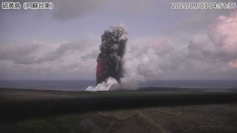


September 8, 2025 at 5:03 AM
Updates from JMA regarding the eruption of Iwojima (Ogasawara Io-to).
www.data.jma.go.jp/vois/data/re...
www.data.jma.go.jp/vois/data/re...
JMA reported Iwojima (Ogasawara Io-to) is erupting.
Image from Himawari-9 satellite. weather-models.info/latest/himaw...
Image from Himawari-9 satellite. weather-models.info/latest/himaw...

September 2, 2025 at 5:02 AM
JMA reported Iwojima (Ogasawara Io-to) is erupting.
Image from Himawari-9 satellite. weather-models.info/latest/himaw...
Image from Himawari-9 satellite. weather-models.info/latest/himaw...
Today is the National Disaster Prevention Day in Japan, commemorating the 1923 Great Kanto Earthquake which devastated Tokyo and Yokohama.
Here is the ground displacements map after the EQ, which was of course made without GPS or InSAR...
www.gsi.go.jp/kohokocho/ko...
Here is the ground displacements map after the EQ, which was of course made without GPS or InSAR...
www.gsi.go.jp/kohokocho/ko...

September 1, 2025 at 1:15 AM
Today is the National Disaster Prevention Day in Japan, commemorating the 1923 Great Kanto Earthquake which devastated Tokyo and Yokohama.
Here is the ground displacements map after the EQ, which was of course made without GPS or InSAR...
www.gsi.go.jp/kohokocho/ko...
Here is the ground displacements map after the EQ, which was of course made without GPS or InSAR...
www.gsi.go.jp/kohokocho/ko...