Dr. Sam McClatchie
banner
fishocean.bsky.social
Dr. Sam McClatchie
@fishocean.bsky.social

Fisheries oceanographer (retired, NOAA Southwest Fisheries Science Center). Led the NOAA CalCOFI program for 11 years (2007-2011) prior to returning to New Zealand. Developer of Fishing Maps (www.fishingmaps.info).

Environmental science 62%
Geography 19%

SST, fronts, currents and chlorophyll maps available daily for gamefishing Costa Rica. 
#sportfishing #gamefishing #fishingcostarica #yellowfin #marlin

Interpreting satellite maps for gamefishing involves looking for consistent patterns in SST, fronts, currents and chlorophyll (when available) over several days. Selecting the frontal zones is made easier by using the SST frontal gradient maps. 

#gamefishing #biggamefishing #yellowfin #marlin
Senate boosts funding for NASA, NOAA, and NSF beyond Trump's request, emphasizing science and research investment.
Congress passes bill to fund U.S. science agencies, rebuffing Trump’s requested cuts
Senate boosts funding for NASA, NOAA, and NSF beyond Trump's request, emphasizing science and research investment.
www.nbcnews.com

Nothing like a few sunny days in New Zealand to bring out the chlorophyll in Fishing Maps.

www.fishingmaps.info

#oceanography #fisheries #sportfishing #marlin #tuna

Are single pass Sea Surface Temperature (SST) images the best way to detect fronts for gamefishing? Checkout the new blog on the Fishing Maps (zurl.co/zlvlj) website.

zurl.co/9DtXs

Although the fronts are weak, the combined maps suggest the 200 metre contour would be a favourable area for gamefish to find feed.

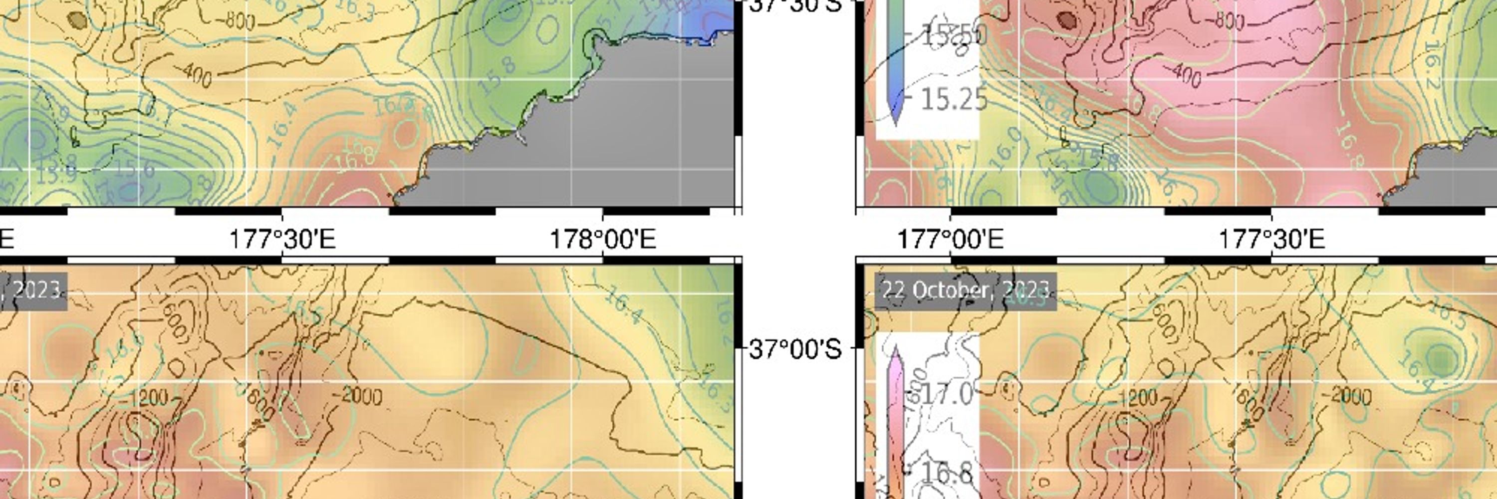
Maps by Fishing Maps (www.fishingmaps.info)

Chlorophyll levels fall off around the 200 metre mark, and there is a consistent southward current in the 100 to 200 metre depth zone off Whitianga.

Consistent patterns in the sea surface temperature, currents, and chlorophyll create the structure that allows plankton concentrations to develop over several days. In this example off Tutukaka, New Zealand, over a 4 day period, SST is cool inshore of the 100 metre line.

Yellowfin tuna are back in New Zealand and the summer recreational gamefishing is going off. What's going on?
zurl.co/qs0oh

Which level 2 SWOT product is this Lily? Are you accessing the files from PO-DAAC? I think it's time for me to see if I can use these data for my Fishing Maps product (www.fishingmaps.info) instead of, or in addition to, the 8km resolution Copernicus product that I currently use.

But in the southern hemisphere, the rotation around a high goes anticlockwise, as you can see in this large eddy off the coast of Sydney, Australia. So don't be confused by blogs written for American audiences. It's different down under.

We know the southern hemisphere is special, but what's that got to do with ocean eddies? In the northern hemisphere, high sea surface height (SSH) in the centre of an eddy is associated with clockwise rotating currents.

Chlorophyll data are sparse due to clouds and missing data, but indication are that chlorophyll is high in the cool water. The offshore cool water edge is a likely region to find plankton feed.

There are strong sea surface temperature (SST) contrasts off the Coromandel Peninsula, New Zealand, with cool water nearshore. The gradients are not sharp enough to produce well defined fronts, probably due to recent windy weather.

Cloud-free Sea Surface Temperature off the Mahia Peninsula, on the east coast of New Zealand reveals distinct temperature variations north and south of a significant eddy. 🌊 #Oceanography #NewZealand
Our first direct hit. Oddly our oyster work is the most popular thing we do. Great return on investment for taxpayers funding bay restoration.

cambridgespy.substack.com/p/horn-point...
Horn Point Confirms Deep NOAA Cuts
A nearly 50 percent reduction in federal funding for oyster restoration threatens to sharply reduce oyster production in the Chesapeake Bay, jeopardizing one of the region’s most successful environmen...
cambridgespy.substack.com

“Deliberately dismantling an institution so central to weather forecasting and climate change prediction would not only undermine scientific research, it would leave people across the nation less prepared for the dangers of a warming world."

www.ucs.org/about/news/t...

open.substack.com/pub/contrari...

The barbarians are attempting to burn down the nation.
Stephen Miller is the Poster Boy for the Rabid MAGA Movement
The more voters see of him, the more repulsed they’ll be
open.substack.com

Some have to learn the hard way, I guess. If they can learn when belief contradicts logic.

It's becoming ever more apparent that ships should focus on what the autonomous vehicles cannot do.

#fisheries #oceanography
ABS Issues Full Class for Saildrone Surveyor, Setting New Benchmark for USVs
Saildrone USVs are the world’s only unmanned platform to receive classification from ABS—no other USV or UUV has been fully classed by any classification society.
www.saildrone.com

There are times when the patterns of temperature on the ocean are simply beautiful, whether you are into the science or not.

www.fishingmaps.info
#fisheries #oceanography

Great to see Congress pushing back on this one.

ecomagazine.com/news/policy/...