


Hamish Reid
@hamishreidphoto.bsky.social
No one ever looked at one of my photos and said “what a lovely landscape!”.
Snapshots from a life, in no particular order. All mine unless otherwise noted; dates approximate. Unintentional do-overs likely.
Main website: https://photography.hamishreid.com
Snapshots from a life, in no particular order. All mine unless otherwise noted; dates approximate. Unintentional do-overs likely.
Main website: https://photography.hamishreid.com
Silver Lake (north of Baker), from near State Route 127, California (mid-1990's).
#photography #LandscapePhotography #Desert #California #BlackAndWhite #ruins
#photography #LandscapePhotography #Desert #California #BlackAndWhite #ruins

November 30, 2025 at 5:01 PM
Silver Lake (north of Baker), from near State Route 127, California (mid-1990's).
#photography #LandscapePhotography #Desert #California #BlackAndWhite #ruins
#photography #LandscapePhotography #Desert #California #BlackAndWhite #ruins
The old White Bay Power Station, Rozelle (Sydney), 1988. I used to walk past this fave monster at least once a week on the way to band practice. Of course it's been gentrified now…
#photography #UrbanLandscape #Sydney #Australia #BlackAndWhite #PreGentrification #Streetscape
#photography #UrbanLandscape #Sydney #Australia #BlackAndWhite #PreGentrification #Streetscape

November 29, 2025 at 3:40 PM
The old White Bay Power Station, Rozelle (Sydney), 1988. I used to walk past this fave monster at least once a week on the way to band practice. Of course it's been gentrified now…
#photography #UrbanLandscape #Sydney #Australia #BlackAndWhite #PreGentrification #Streetscape
#photography #UrbanLandscape #Sydney #Australia #BlackAndWhite #PreGentrification #Streetscape
My last Now and Then for a while… Brocks Lane, Newtown, Sydney, 1988, pre-gentrification. As always with gentrified Newtown, it’s quite different nowadays, but still recognisable.
#photography #UrbanLandscape #Streetscape #BlackAndWhite #Newtown #Sydney #Australia #PreGentrification
#photography #UrbanLandscape #Streetscape #BlackAndWhite #Newtown #Sydney #Australia #PreGentrification

November 28, 2025 at 5:20 PM
My last Now and Then for a while… Brocks Lane, Newtown, Sydney, 1988, pre-gentrification. As always with gentrified Newtown, it’s quite different nowadays, but still recognisable.
#photography #UrbanLandscape #Streetscape #BlackAndWhite #Newtown #Sydney #Australia #PreGentrification
#photography #UrbanLandscape #Streetscape #BlackAndWhite #Newtown #Sydney #Australia #PreGentrification
One more Now and Then from Newton (Sydney) in 1988… 105 Wilson Street pre-gentrification, when it housed a struggling artist studio of some sort, IIRC.
#photography #UrbanLandscape #Streetscape #BlackAndWhite #Newtown #Sydney #Australia #PreGentrification
#photography #UrbanLandscape #Streetscape #BlackAndWhite #Newtown #Sydney #Australia #PreGentrification

November 26, 2025 at 3:35 PM
One more Now and Then from Newton (Sydney) in 1988… 105 Wilson Street pre-gentrification, when it housed a struggling artist studio of some sort, IIRC.
#photography #UrbanLandscape #Streetscape #BlackAndWhite #Newtown #Sydney #Australia #PreGentrification
#photography #UrbanLandscape #Streetscape #BlackAndWhite #Newtown #Sydney #Australia #PreGentrification
Now and Then… Alpha House in 1988, at the top end of King Street, Newtown (Sydney), just as developers got to it. It used to be a haven for artists, musicians, etc., but gentrification loomed…
#photography #UrbanLandscape #Streetscape #BlackAndWhite #Newtown #Sydney #Australia #PreGentrification
#photography #UrbanLandscape #Streetscape #BlackAndWhite #Newtown #Sydney #Australia #PreGentrification

November 25, 2025 at 3:09 PM
Now and Then… Alpha House in 1988, at the top end of King Street, Newtown (Sydney), just as developers got to it. It used to be a haven for artists, musicians, etc., but gentrification loomed…
#photography #UrbanLandscape #Streetscape #BlackAndWhite #Newtown #Sydney #Australia #PreGentrification
#photography #UrbanLandscape #Streetscape #BlackAndWhite #Newtown #Sydney #Australia #PreGentrification
Now and then… 131 Wilson Street, Newtown (Sydney), 1988. I used to live a bit further down Wilson Street (on top of a sandwich shop). See comment for current (gentrified) state…
#photography #UrbanLandscape #Streetscape #BlackAndWhite #Newtown #Sydney #Australia #PreGentrification
#photography #UrbanLandscape #Streetscape #BlackAndWhite #Newtown #Sydney #Australia #PreGentrification

November 24, 2025 at 3:17 PM
Now and then… 131 Wilson Street, Newtown (Sydney), 1988. I used to live a bit further down Wilson Street (on top of a sandwich shop). See comment for current (gentrified) state…
#photography #UrbanLandscape #Streetscape #BlackAndWhite #Newtown #Sydney #Australia #PreGentrification
#photography #UrbanLandscape #Streetscape #BlackAndWhite #Newtown #Sydney #Australia #PreGentrification
Warren Street Tube Station (London), 1986. My last London Underground pic for a while… one that might convey the weird mix of grime and starkly-lit geometry and strange angles that was the daily Tube experience back then.
#photography #LondonUnderground #London #1980s #UrbanLandscape #BlackAndWhite
#photography #LondonUnderground #London #1980s #UrbanLandscape #BlackAndWhite

November 23, 2025 at 3:47 PM
Warren Street Tube Station (London), 1986. My last London Underground pic for a while… one that might convey the weird mix of grime and starkly-lit geometry and strange angles that was the daily Tube experience back then.
#photography #LondonUnderground #London #1980s #UrbanLandscape #BlackAndWhite
#photography #LondonUnderground #London #1980s #UrbanLandscape #BlackAndWhite
Whoosh… one more from Angel Islington, circa 1986. The narrow platform at Angel always kind of worried me when it was crowded…
#photography #LondonUnderground #London #1980s #BlackAndWhite #UrbanLandscape
#photography #LondonUnderground #London #1980s #BlackAndWhite #UrbanLandscape

November 22, 2025 at 3:37 PM
Whoosh… one more from Angel Islington, circa 1986. The narrow platform at Angel always kind of worried me when it was crowded…
#photography #LondonUnderground #London #1980s #BlackAndWhite #UrbanLandscape
#photography #LondonUnderground #London #1980s #BlackAndWhite #UrbanLandscape
Another mid-1980's pic of Angel Islington Tube station (London Underground). From my photo essay Under London — London Underground in the 1980's (photography.hamishreid.com/Photo-Essays...).
#photography #LondonUnderground #UrbanLandscape #London #1980s
#photography #LondonUnderground #UrbanLandscape #London #1980s

November 20, 2025 at 4:43 PM
Another mid-1980's pic of Angel Islington Tube station (London Underground). From my photo essay Under London — London Underground in the 1980's (photography.hamishreid.com/Photo-Essays...).
#photography #LondonUnderground #UrbanLandscape #London #1980s
#photography #LondonUnderground #UrbanLandscape #London #1980s
The old Angel Islington Tube station, mid-1980's London. I loved the weird combination of mould and grime, polished brass, odd geometry, and scurrying rats I'd see there every day…
#photography #LondonUnderground #UrbanLandscape #London #1980s
#photography #LondonUnderground #UrbanLandscape #London #1980s

November 19, 2025 at 4:11 PM
The old Angel Islington Tube station, mid-1980's London. I loved the weird combination of mould and grime, polished brass, odd geometry, and scurrying rats I'd see there every day…
#photography #LondonUnderground #UrbanLandscape #London #1980s
#photography #LondonUnderground #UrbanLandscape #London #1980s
The Big Merino, Goulburn (Australia, 2025). Another Australian Big Thing (en.wikipedia.org/wiki/Big_thi... ), this time on my way to Canberra…
#photography #TravelsWithAniPhone #RoadsideAttraction #Goulburn #Australia
#photography #TravelsWithAniPhone #RoadsideAttraction #Goulburn #Australia


November 18, 2025 at 3:57 PM
The Big Merino, Goulburn (Australia, 2025). Another Australian Big Thing (en.wikipedia.org/wiki/Big_thi... ), this time on my way to Canberra…
#photography #TravelsWithAniPhone #RoadsideAttraction #Goulburn #Australia
#photography #TravelsWithAniPhone #RoadsideAttraction #Goulburn #Australia
The Big Prawn, Ballina, Australia (2025). One of Australia's many "Big" things (see en.wikipedia.org/wiki/Big_thi... ), I couldn't resist this one which has been around for ever (I grew up in coastal Australia a long time ago).
#photography #TravelsWithAniPhone #Australia #RoadsideAttraction
#photography #TravelsWithAniPhone #Australia #RoadsideAttraction

November 17, 2025 at 5:32 PM
The Big Prawn, Ballina, Australia (2025). One of Australia's many "Big" things (see en.wikipedia.org/wiki/Big_thi... ), I couldn't resist this one which has been around for ever (I grew up in coastal Australia a long time ago).
#photography #TravelsWithAniPhone #Australia #RoadsideAttraction
#photography #TravelsWithAniPhone #Australia #RoadsideAttraction
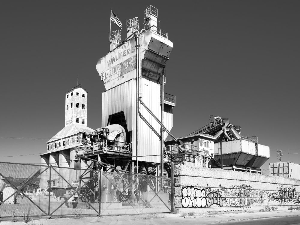
Lone Star (Oakland, 2024). This old but still-working concrete plant has featured in my streetscapes for literally decades now. See youtu.be/85tVcD-iPS4 for a video tribute I made last year.
#photography #streetscape #BlackAndWhite #Oakland #California
#photography #streetscape #BlackAndWhite #Oakland #California


November 16, 2025 at 4:15 PM
Lone Star (Oakland, 2024). This old but still-working concrete plant has featured in my streetscapes for literally decades now. See youtu.be/85tVcD-iPS4 for a video tribute I made last year.
#photography #streetscape #BlackAndWhite #Oakland #California
#photography #streetscape #BlackAndWhite #Oakland #California


November 14, 2025 at 3:26 PM
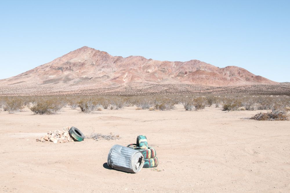
Stoddard Wells Road, California (2009).
#photography #LandscapePhotography #Mojave #Desert #California #Roadscape
#photography #LandscapePhotography #Mojave #Desert #California #Roadscape
November 12, 2025 at 6:59 PM
Stoddard Wells Road, California (2009).
#photography #LandscapePhotography #Mojave #Desert #California #Roadscape
#photography #LandscapePhotography #Mojave #Desert #California #Roadscape

November 11, 2025 at 4:54 PM
BARBER COSMO (International Boulevard / East 14th, Oakland, maybe fifteen years ago).
#photography #Streetscape #oakland #california
#photography #Streetscape #oakland #california

November 10, 2025 at 5:12 PM
BARBER COSMO (International Boulevard / East 14th, Oakland, maybe fifteen years ago).
#photography #Streetscape #oakland #california
#photography #Streetscape #oakland #california
Newtown (Sydney, 2025). I've been taking some variant of this photo for decades; it hasn't changed much (or at all) in that time while so much around it's now almost unrecognisable…
#photography #UrbanLandscape #StrollsWithAniPhone #Newtown #Sydney #Australia #ruins
#photography #UrbanLandscape #StrollsWithAniPhone #Newtown #Sydney #Australia #ruins

November 7, 2025 at 5:03 PM
Newtown (Sydney, 2025). I've been taking some variant of this photo for decades; it hasn't changed much (or at all) in that time while so much around it's now almost unrecognisable…
#photography #UrbanLandscape #StrollsWithAniPhone #Newtown #Sydney #Australia #ruins
#photography #UrbanLandscape #StrollsWithAniPhone #Newtown #Sydney #Australia #ruins
Slough Road, California, a few years ago (Mt Shasta, of course).
#photography #LandscapePhotography #BlackAndWhite #Volcanic #California #SiskiyouCounty #MtShasta
#photography #LandscapePhotography #BlackAndWhite #Volcanic #California #SiskiyouCounty #MtShasta

October 31, 2025 at 8:39 PM
Slough Road, California, a few years ago (Mt Shasta, of course).
#photography #LandscapePhotography #BlackAndWhite #Volcanic #California #SiskiyouCounty #MtShasta
#photography #LandscapePhotography #BlackAndWhite #Volcanic #California #SiskiyouCounty #MtShasta
Black Butte, looking a little fluffy one morning (California, 2022).
#photography #LandscapePhotography #SiskiyouCounty #MtShasta #Volcanic #California
#photography #LandscapePhotography #SiskiyouCounty #MtShasta #Volcanic #California

October 28, 2025 at 8:42 AM
Black Butte, looking a little fluffy one morning (California, 2022).
#photography #LandscapePhotography #SiskiyouCounty #MtShasta #Volcanic #California
#photography #LandscapePhotography #SiskiyouCounty #MtShasta #Volcanic #California
Incoming (Slough Road, California, 2022).
#photography #LandscapePhotography #MtShasta #California #weather #TheRoadAhead #SiskiyouCounty
#photography #LandscapePhotography #MtShasta #California #weather #TheRoadAhead #SiskiyouCounty

October 26, 2025 at 8:42 PM
Incoming (Slough Road, California, 2022).
#photography #LandscapePhotography #MtShasta #California #weather #TheRoadAhead #SiskiyouCounty
#photography #LandscapePhotography #MtShasta #California #weather #TheRoadAhead #SiskiyouCounty
Sunrise, Barstow (California, 2013).
#photography #LandscapePhotography #Mojave #Desert #California #sunrise
#photography #LandscapePhotography #Mojave #Desert #California #sunrise

October 24, 2025 at 9:25 PM
Sunrise, Barstow (California, 2013).
#photography #LandscapePhotography #Mojave #Desert #California #sunrise
#photography #LandscapePhotography #Mojave #Desert #California #sunrise
First Lake, on the Lakes trail 9,000-something feet up out of Big Pine Canyon, in California's Eastern Sierra a few years ago. One of my fave day hikes…
#photography #LandscapePhotography #StrollsWithAniPhone #EasternSierra #California
#photography #LandscapePhotography #StrollsWithAniPhone #EasternSierra #California

October 22, 2025 at 8:35 PM
First Lake, on the Lakes trail 9,000-something feet up out of Big Pine Canyon, in California's Eastern Sierra a few years ago. One of my fave day hikes…
#photography #LandscapePhotography #StrollsWithAniPhone #EasternSierra #California
#photography #LandscapePhotography #StrollsWithAniPhone #EasternSierra #California
Harsh (smoky) light, Panamint Valley from Hunter Mountain Road, California (a decade or two ago).
#photography #DeathValleyNationalPark #DVNP #Mojave #Desert #California
#photography #DeathValleyNationalPark #DVNP #Mojave #Desert #California

October 21, 2025 at 11:23 PM
Harsh (smoky) light, Panamint Valley from Hunter Mountain Road, California (a decade or two ago).
#photography #DeathValleyNationalPark #DVNP #Mojave #Desert #California
#photography #DeathValleyNationalPark #DVNP #Mojave #Desert #California
Black Butte from Slough Road, Siskyou County, California.
#photography #LandscapePhotography #TheRoadAhead #MtShasta #Volcanic #BlackAndWhite
#photography #LandscapePhotography #TheRoadAhead #MtShasta #Volcanic #BlackAndWhite

October 19, 2025 at 8:33 PM
Black Butte from Slough Road, Siskyou County, California.
#photography #LandscapePhotography #TheRoadAhead #MtShasta #Volcanic #BlackAndWhite
#photography #LandscapePhotography #TheRoadAhead #MtShasta #Volcanic #BlackAndWhite