


Javier Olivares
@javierolivares.bsky.social
Software Engineering I Senior IT Consultant I
Nature Photography & Landscape Photographer I
North by Northwest.
Nature Photography & Landscape Photographer I
North by Northwest.
Pinned
@ESA_EO : As reported in the 2022 @ec.europa.eu
State of the Climate by @copernicusecmwf.bsky.social between 1993 and 2022, Earth experienced an average sea level increase of around:
+3.3±0.3 mm (globally)
+2–4 mm (in Europe)
This animation shows the mean sea-level trend for the same period.
State of the Climate by @copernicusecmwf.bsky.social between 1993 and 2022, Earth experienced an average sea level increase of around:
+3.3±0.3 mm (globally)
+2–4 mm (in Europe)
This animation shows the mean sea-level trend for the same period.
What calling and singing reveal about bowhead whales.
New scientific study by the Ocean Acoustics Group at AWI suggests breeding grounds.
Whale Song Audios:
You can download examples of bowhead whale songs from our media centre: multimedia.awi.de/pincollectio... @awi.de @helmholtzhzi.bsky.social
New scientific study by the Ocean Acoustics Group at AWI suggests breeding grounds.
Whale Song Audios:
You can download examples of bowhead whale songs from our media centre: multimedia.awi.de/pincollectio... @awi.de @helmholtzhzi.bsky.social


December 16, 2025 at 5:54 PM
What calling and singing reveal about bowhead whales.
New scientific study by the Ocean Acoustics Group at AWI suggests breeding grounds.
Whale Song Audios:
You can download examples of bowhead whale songs from our media centre: multimedia.awi.de/pincollectio... @awi.de @helmholtzhzi.bsky.social
New scientific study by the Ocean Acoustics Group at AWI suggests breeding grounds.
Whale Song Audios:
You can download examples of bowhead whale songs from our media centre: multimedia.awi.de/pincollectio... @awi.de @helmholtzhzi.bsky.social
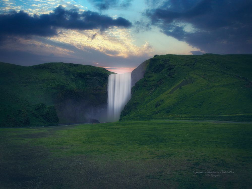
Fjaðrárgljúfur,
Kirkjubæjarklaustur, Suðurland, Ísland
@visiticeland.bsky.social @photoshop.adobe.com
#landscapephotography #icelandwaterfalls #Suðurland
www.visiticeland.com
Kirkjubæjarklaustur, Suðurland, Ísland
@visiticeland.bsky.social @photoshop.adobe.com
#landscapephotography #icelandwaterfalls #Suðurland
www.visiticeland.com

December 16, 2025 at 8:53 AM
Fjaðrárgljúfur,
Kirkjubæjarklaustur, Suðurland, Ísland
@visiticeland.bsky.social @photoshop.adobe.com
#landscapephotography #icelandwaterfalls #Suðurland
www.visiticeland.com
Kirkjubæjarklaustur, Suðurland, Ísland
@visiticeland.bsky.social @photoshop.adobe.com
#landscapephotography #icelandwaterfalls #Suðurland
www.visiticeland.com
Research icebreaker Polarstern sets sail for the Antarctic Weddell Sea.
An international research team led by the University of Rostock is investigating the impact of climate change on biodiversity in Antarctica. @awi.de @helmholtz.de
www.uni-rostock.de/en/
An international research team led by the University of Rostock is investigating the impact of climate change on biodiversity in Antarctica. @awi.de @helmholtz.de
www.uni-rostock.de/en/


December 15, 2025 at 5:16 PM
Research icebreaker Polarstern sets sail for the Antarctic Weddell Sea.
An international research team led by the University of Rostock is investigating the impact of climate change on biodiversity in Antarctica. @awi.de @helmholtz.de
www.uni-rostock.de/en/
An international research team led by the University of Rostock is investigating the impact of climate change on biodiversity in Antarctica. @awi.de @helmholtz.de
www.uni-rostock.de/en/
Gufufoss,
Seyðisfjörður, Austurland, Ísland
@visiticeland.bsky.social @euiniceland.bsky.social
#landascapephotogaphy #icelandicwaterfalls #Gufufoss, guidetoiceland.is/travel-icela...
Seyðisfjörður, Austurland, Ísland
@visiticeland.bsky.social @euiniceland.bsky.social
#landascapephotogaphy #icelandicwaterfalls #Gufufoss, guidetoiceland.is/travel-icela...

December 13, 2025 at 9:37 AM
Gufufoss,
Seyðisfjörður, Austurland, Ísland
@visiticeland.bsky.social @euiniceland.bsky.social
#landascapephotogaphy #icelandicwaterfalls #Gufufoss, guidetoiceland.is/travel-icela...
Seyðisfjörður, Austurland, Ísland
@visiticeland.bsky.social @euiniceland.bsky.social
#landascapephotogaphy #icelandicwaterfalls #Gufufoss, guidetoiceland.is/travel-icela...
Goðafoss,
Norðurland Eystra Region, Ísland
#landscapephotography #icelandicphotos
@visiticeland.bsky.social @icelandgeology.bsky.social
www.inspiredbyiceland.com/visit
Norðurland Eystra Region, Ísland
#landscapephotography #icelandicphotos
@visiticeland.bsky.social @icelandgeology.bsky.social
www.inspiredbyiceland.com/visit

November 6, 2025 at 6:47 AM
Goðafoss,
Norðurland Eystra Region, Ísland
#landscapephotography #icelandicphotos
@visiticeland.bsky.social @icelandgeology.bsky.social
www.inspiredbyiceland.com/visit
Norðurland Eystra Region, Ísland
#landscapephotography #icelandicphotos
@visiticeland.bsky.social @icelandgeology.bsky.social
www.inspiredbyiceland.com/visit
Brygen Bergen, Norway
#landscapephotography #streetphotography
@visitnorway.bsky.social @lightroom.adobe.com
www.visitnorway.com/places-to-go...
#landscapephotography #streetphotography
@visitnorway.bsky.social @lightroom.adobe.com
www.visitnorway.com/places-to-go...

October 19, 2025 at 8:55 AM
September 2025 was the third-warmest on record globally.
The bulletin reports that September 2025 was the third-warmest September ever globally, with an average #ERA5 surface air temperature of 16.11°C, which is 0.66°C above the 1991–2020 average for the month.
@copernicusecmwf.bsky.social
The bulletin reports that September 2025 was the third-warmest September ever globally, with an average #ERA5 surface air temperature of 16.11°C, which is 0.66°C above the 1991–2020 average for the month.
@copernicusecmwf.bsky.social

October 13, 2025 at 9:37 AM
September 2025 was the third-warmest on record globally.
The bulletin reports that September 2025 was the third-warmest September ever globally, with an average #ERA5 surface air temperature of 16.11°C, which is 0.66°C above the 1991–2020 average for the month.
@copernicusecmwf.bsky.social
The bulletin reports that September 2025 was the third-warmest September ever globally, with an average #ERA5 surface air temperature of 16.11°C, which is 0.66°C above the 1991–2020 average for the month.
@copernicusecmwf.bsky.social
Dettifoss, Jökulsárgljúfur
National Park, Austurland
#landscapephotography #icelandicwaterfalls
#travelphotography
@visiticeland.bsky.social
National Park, Austurland
#landscapephotography #icelandicwaterfalls
#travelphotography
@visiticeland.bsky.social

September 25, 2025 at 6:10 PM
Dettifoss, Jökulsárgljúfur
National Park, Austurland
#landscapephotography #icelandicwaterfalls
#travelphotography
@visiticeland.bsky.social
National Park, Austurland
#landscapephotography #icelandicwaterfalls
#travelphotography
@visiticeland.bsky.social

September 16, 2025 at 6:30 AM
CONTRASTS expedition with the research icebreaker Polarstern, explored different types of sea ice in parallel
The international and interdisciplinary research team, led by the Alfred Wegener Institute, focused on the summer melting of Arctic sea ice in three different regimes.
@awi.de @helmholtz.de
The international and interdisciplinary research team, led by the Alfred Wegener Institute, focused on the summer melting of Arctic sea ice in three different regimes.
@awi.de @helmholtz.de


September 9, 2025 at 3:16 AM
CONTRASTS expedition with the research icebreaker Polarstern, explored different types of sea ice in parallel
The international and interdisciplinary research team, led by the Alfred Wegener Institute, focused on the summer melting of Arctic sea ice in three different regimes.
@awi.de @helmholtz.de
The international and interdisciplinary research team, led by the Alfred Wegener Institute, focused on the summer melting of Arctic sea ice in three different regimes.
@awi.de @helmholtz.de
Lake on the 79°N Glacier is splitting the ice – leaving permanent changes.
A new AWI study shows that an approximately 21 square kilometre meltwater lake has caused gigantic cracks in the ice and that the water flowing off is lifting the glacier
@awi.de @helmholtz.de
A new AWI study shows that an approximately 21 square kilometre meltwater lake has caused gigantic cracks in the ice and that the water flowing off is lifting the glacier
@awi.de @helmholtz.de


August 15, 2025 at 7:20 AM
Lake on the 79°N Glacier is splitting the ice – leaving permanent changes.
A new AWI study shows that an approximately 21 square kilometre meltwater lake has caused gigantic cracks in the ice and that the water flowing off is lifting the glacier
@awi.de @helmholtz.de
A new AWI study shows that an approximately 21 square kilometre meltwater lake has caused gigantic cracks in the ice and that the water flowing off is lifting the glacier
@awi.de @helmholtz.de
Greenland subglacial lake outburst.
Using data from several Earth-observing satellites, including ESA’s CryoSat and the Copernicus Sentinel-1 and Sentinel-2 missions, scientists have discovered that a huge flood beneath the Greenland Ice Sheet @esaearth.esa.int @esa.int
Using data from several Earth-observing satellites, including ESA’s CryoSat and the Copernicus Sentinel-1 and Sentinel-2 missions, scientists have discovered that a huge flood beneath the Greenland Ice Sheet @esaearth.esa.int @esa.int
August 5, 2025 at 7:53 AM
Greenland subglacial lake outburst.
Using data from several Earth-observing satellites, including ESA’s CryoSat and the Copernicus Sentinel-1 and Sentinel-2 missions, scientists have discovered that a huge flood beneath the Greenland Ice Sheet @esaearth.esa.int @esa.int
Using data from several Earth-observing satellites, including ESA’s CryoSat and the Copernicus Sentinel-1 and Sentinel-2 missions, scientists have discovered that a huge flood beneath the Greenland Ice Sheet @esaearth.esa.int @esa.int
Húsavíkurkirkja, Húsavík,
Norðurland Eystra Region, Ísland
#Iceland #landscapephotography
#PicofTheDay #HúsavikChurch
@adobe.com
www.visiticeland.com
Norðurland Eystra Region, Ísland
#Iceland #landscapephotography
#PicofTheDay #HúsavikChurch
@adobe.com
www.visiticeland.com

July 10, 2025 at 7:43 AM
Húsavíkurkirkja, Húsavík,
Norðurland Eystra Region, Ísland
#Iceland #landscapephotography
#PicofTheDay #HúsavikChurch
@adobe.com
www.visiticeland.com
Norðurland Eystra Region, Ísland
#Iceland #landscapephotography
#PicofTheDay #HúsavikChurch
@adobe.com
www.visiticeland.com
The Skeiðarárjökull glacier in southern Iceland plays a key role in the region’s hydrological cycle
As an outlet glacier of Vatnajökull it is closely monitored due to its repeated history of glacial outburst floods which have shaped the surrounding landscape
@ec.europa.eu
perlan.is/articles/ske...
As an outlet glacier of Vatnajökull it is closely monitored due to its repeated history of glacial outburst floods which have shaped the surrounding landscape
@ec.europa.eu
perlan.is/articles/ske...

July 9, 2025 at 12:44 PM
The Skeiðarárjökull glacier in southern Iceland plays a key role in the region’s hydrological cycle
As an outlet glacier of Vatnajökull it is closely monitored due to its repeated history of glacial outburst floods which have shaped the surrounding landscape
@ec.europa.eu
perlan.is/articles/ske...
As an outlet glacier of Vatnajökull it is closely monitored due to its repeated history of glacial outburst floods which have shaped the surrounding landscape
@ec.europa.eu
perlan.is/articles/ske...
Húsavík Harbour,
Norðurland Eystra Region, Ísland
#Iceland #landscapephotography
#PicofTheDay #WhalesWatching
#Travelphotography
www.visiticeland.com @adobe.com
Norðurland Eystra Region, Ísland
#Iceland #landscapephotography
#PicofTheDay #WhalesWatching
#Travelphotography
www.visiticeland.com @adobe.com

July 3, 2025 at 9:52 AM
Húsavík Harbour,
Norðurland Eystra Region, Ísland
#Iceland #landscapephotography
#PicofTheDay #WhalesWatching
#Travelphotography
www.visiticeland.com @adobe.com
Norðurland Eystra Region, Ísland
#Iceland #landscapephotography
#PicofTheDay #WhalesWatching
#Travelphotography
www.visiticeland.com @adobe.com
Journey through space and time.
The latest Polarstern expedition is off to explore ice floe types from the past, present and future.
On Wednesday, 2 July 2025, the Polarstern will set sail from Tromsø, Norway, embarking on an expedition to the Arctic Ocean. @awi.de @meereisportal.bsky.social
The latest Polarstern expedition is off to explore ice floe types from the past, present and future.
On Wednesday, 2 July 2025, the Polarstern will set sail from Tromsø, Norway, embarking on an expedition to the Arctic Ocean. @awi.de @meereisportal.bsky.social


July 3, 2025 at 1:38 AM
Journey through space and time.
The latest Polarstern expedition is off to explore ice floe types from the past, present and future.
On Wednesday, 2 July 2025, the Polarstern will set sail from Tromsø, Norway, embarking on an expedition to the Arctic Ocean. @awi.de @meereisportal.bsky.social
The latest Polarstern expedition is off to explore ice floe types from the past, present and future.
On Wednesday, 2 July 2025, the Polarstern will set sail from Tromsø, Norway, embarking on an expedition to the Arctic Ocean. @awi.de @meereisportal.bsky.social
Phytoplankton bloom in the English Channel.
Phytoplankton blooms occur almost every spring in the English Channel, driven by a combination of environmental factors which converge during the seasonal transition.
@copernicusecmwf.bsky.social @copernicusmarine.bsky.social
@ec.europa.eu #Sentinel-2
Phytoplankton blooms occur almost every spring in the English Channel, driven by a combination of environmental factors which converge during the seasonal transition.
@copernicusecmwf.bsky.social @copernicusmarine.bsky.social
@ec.europa.eu #Sentinel-2

June 23, 2025 at 9:19 AM
Phytoplankton bloom in the English Channel.
Phytoplankton blooms occur almost every spring in the English Channel, driven by a combination of environmental factors which converge during the seasonal transition.
@copernicusecmwf.bsky.social @copernicusmarine.bsky.social
@ec.europa.eu #Sentinel-2
Phytoplankton blooms occur almost every spring in the English Channel, driven by a combination of environmental factors which converge during the seasonal transition.
@copernicusecmwf.bsky.social @copernicusmarine.bsky.social
@ec.europa.eu #Sentinel-2
Skógafoss,
Suðurland, Ísland
#Iceland #skógafoss #waterfall #suðurland
#landscapephotography #PicofTheDay
www.visiticeland.com
Suðurland, Ísland
#Iceland #skógafoss #waterfall #suðurland
#landscapephotography #PicofTheDay
www.visiticeland.com
June 21, 2025 at 9:45 AM
Skógafoss,
Suðurland, Ísland
#Iceland #skógafoss #waterfall #suðurland
#landscapephotography #PicofTheDay
www.visiticeland.com
Suðurland, Ísland
#Iceland #skógafoss #waterfall #suðurland
#landscapephotography #PicofTheDay
www.visiticeland.com
May was the second warmest May on record globally.
The Copernicus Climate Change Service (C3S) has published its latest monthly Climate Bulletin, focused on key climate trends in May 2025.
@copernicusecmwf.bsky.social @ec.europa.eu
climate.copernicus.eu/surface-air-...
The Copernicus Climate Change Service (C3S) has published its latest monthly Climate Bulletin, focused on key climate trends in May 2025.
@copernicusecmwf.bsky.social @ec.europa.eu
climate.copernicus.eu/surface-air-...

June 17, 2025 at 8:31 AM
May was the second warmest May on record globally.
The Copernicus Climate Change Service (C3S) has published its latest monthly Climate Bulletin, focused on key climate trends in May 2025.
@copernicusecmwf.bsky.social @ec.europa.eu
climate.copernicus.eu/surface-air-...
The Copernicus Climate Change Service (C3S) has published its latest monthly Climate Bulletin, focused on key climate trends in May 2025.
@copernicusecmwf.bsky.social @ec.europa.eu
climate.copernicus.eu/surface-air-...
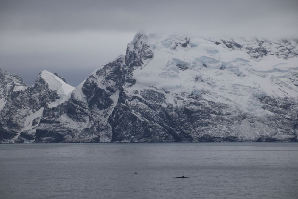
Krill fishing in the Antarctic: overlaps with consequences.
Acoustic data reveal when and where fishing vessels compete with whales and penguins for krill in the Southern Ocean – and what this entails for the ecosystem.
@awi.de
doi.org/10.1073/pnas...
Acoustic data reveal when and where fishing vessels compete with whales and penguins for krill in the Southern Ocean – and what this entails for the ecosystem.
@awi.de
doi.org/10.1073/pnas...


June 17, 2025 at 6:34 AM
Krill fishing in the Antarctic: overlaps with consequences.
Acoustic data reveal when and where fishing vessels compete with whales and penguins for krill in the Southern Ocean – and what this entails for the ecosystem.
@awi.de
doi.org/10.1073/pnas...
Acoustic data reveal when and where fishing vessels compete with whales and penguins for krill in the Southern Ocean – and what this entails for the ecosystem.
@awi.de
doi.org/10.1073/pnas...
Húsavík Harbour,
Norðurland Eystra Region, Ísland
#Seascapephotography #Whales #Iceland
#Travelphotography #PicoftheDay
@adobe.com
Norðurland Eystra Region, Ísland
#Seascapephotography #Whales #Iceland
#Travelphotography #PicoftheDay
@adobe.com

June 4, 2025 at 7:43 AM
Húsavík Harbour,
Norðurland Eystra Region, Ísland
#Seascapephotography #Whales #Iceland
#Travelphotography #PicoftheDay
@adobe.com
Norðurland Eystra Region, Ísland
#Seascapephotography #Whales #Iceland
#Travelphotography #PicoftheDay
@adobe.com
Plastic Credits May Worsen Plastic Problem.
Plastic credits are being promoted as an innovative way of addressing plastic pollution, but the credits could have exactly the opposite effect and exacerbate the crisis, warns an international consortium of scientists. @awi.de
www.awi.de/en/focus/mar...
Plastic credits are being promoted as an innovative way of addressing plastic pollution, but the credits could have exactly the opposite effect and exacerbate the crisis, warns an international consortium of scientists. @awi.de
www.awi.de/en/focus/mar...


June 3, 2025 at 8:38 AM
Plastic Credits May Worsen Plastic Problem.
Plastic credits are being promoted as an innovative way of addressing plastic pollution, but the credits could have exactly the opposite effect and exacerbate the crisis, warns an international consortium of scientists. @awi.de
www.awi.de/en/focus/mar...
Plastic credits are being promoted as an innovative way of addressing plastic pollution, but the credits could have exactly the opposite effect and exacerbate the crisis, warns an international consortium of scientists. @awi.de
www.awi.de/en/focus/mar...
Hayedo de Otzarreta,
Gorbeia Natural Park, Euskadi
#Landscapephotography #Naturephotography #Beechforest
#picoftheday #Euskadi @adobe.com
turismovasco.com/bizkaia/que-...
Gorbeia Natural Park, Euskadi
#Landscapephotography #Naturephotography #Beechforest
#picoftheday #Euskadi @adobe.com
turismovasco.com/bizkaia/que-...

May 31, 2025 at 10:13 AM
Hayedo de Otzarreta,
Gorbeia Natural Park, Euskadi
#Landscapephotography #Naturephotography #Beechforest
#picoftheday #Euskadi @adobe.com
turismovasco.com/bizkaia/que-...
Gorbeia Natural Park, Euskadi
#Landscapephotography #Naturephotography #Beechforest
#picoftheday #Euskadi @adobe.com
turismovasco.com/bizkaia/que-...
How climate change is altering the Arctic Ocean
Polarstern expedition is off to the AWI-Hausgarten long-term observatory.
On 29 May 2025, the Polarstern research vessel set sail from Bremerhaven for the Arctic. @awi.de
www.awi.de/en/about-us/...
follow-polarstern.awi.de
Polarstern expedition is off to the AWI-Hausgarten long-term observatory.
On 29 May 2025, the Polarstern research vessel set sail from Bremerhaven for the Arctic. @awi.de
www.awi.de/en/about-us/...
follow-polarstern.awi.de


May 30, 2025 at 10:14 AM
How climate change is altering the Arctic Ocean
Polarstern expedition is off to the AWI-Hausgarten long-term observatory.
On 29 May 2025, the Polarstern research vessel set sail from Bremerhaven for the Arctic. @awi.de
www.awi.de/en/about-us/...
follow-polarstern.awi.de
Polarstern expedition is off to the AWI-Hausgarten long-term observatory.
On 29 May 2025, the Polarstern research vessel set sail from Bremerhaven for the Arctic. @awi.de
www.awi.de/en/about-us/...
follow-polarstern.awi.de
Irati Beech Forest,
Kingdom of Navarra, Spain
#Landscapephotography #Naturephotography
#Navarra #Forest #picoftheday
@adobe.com
Kingdom of Navarra, Spain
#Landscapephotography #Naturephotography
#Navarra #Forest #picoftheday
@adobe.com

May 29, 2025 at 7:36 AM
Irati Beech Forest,
Kingdom of Navarra, Spain
#Landscapephotography #Naturephotography
#Navarra #Forest #picoftheday
@adobe.com
Kingdom of Navarra, Spain
#Landscapephotography #Naturephotography
#Navarra #Forest #picoftheday
@adobe.com