


Mapterhorn
@mapterhorn.com
Public terrain tiles for interactive web map visualizations
https://mapterhorn.com
https://github.com/mapterhorn
https://mapterhorn.com
https://github.com/mapterhorn
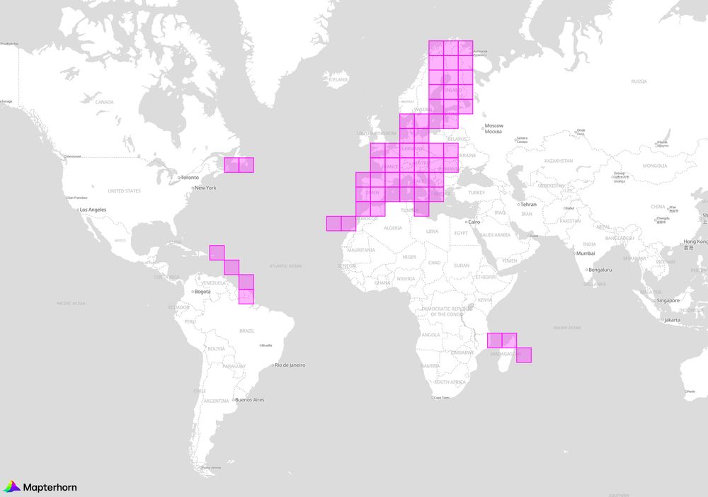
Cyprus, Greenland, Faroe, Iceland, Japan, New Zealand, Norway, Svalbard, Portugal, Madeira, Spain, England, Scotland, Wales, and the United States are now included in Mapterhorn v0.0.7.
Special thanks to Daniel Silk (NZ), Hidenori Fujimura (JP), and Christopher Varjas (US)!
Special thanks to Daniel Silk (NZ), Hidenori Fujimura (JP), and Christopher Varjas (US)!
Mapterhorn
mapterhorn.com
December 29, 2025 at 10:22 PM
Cyprus, Greenland, Faroe, Iceland, Japan, New Zealand, Norway, Svalbard, Portugal, Madeira, Spain, England, Scotland, Wales, and the United States are now included in Mapterhorn v0.0.7.
Special thanks to Daniel Silk (NZ), Hidenori Fujimura (JP), and Christopher Varjas (US)!
Special thanks to Daniel Silk (NZ), Hidenori Fujimura (JP), and Christopher Varjas (US)!
Mapterhorn v0.0.6 brings 1 m resolution for all of Austria. Big thanks to Christopher Varjas for being the first dataset contributor! Also thanks to Pirmin Kalberer for pointing out this source existed...
Enjoy for example St. Anton here: mapterhorn.com/viewer/#map=...
Enjoy for example St. Anton here: mapterhorn.com/viewer/#map=...

December 11, 2025 at 11:03 AM
Mapterhorn v0.0.6 brings 1 m resolution for all of Austria. Big thanks to Christopher Varjas for being the first dataset contributor! Also thanks to Pirmin Kalberer for pointing out this source existed...
Enjoy for example St. Anton here: mapterhorn.com/viewer/#map=...
Enjoy for example St. Anton here: mapterhorn.com/viewer/#map=...
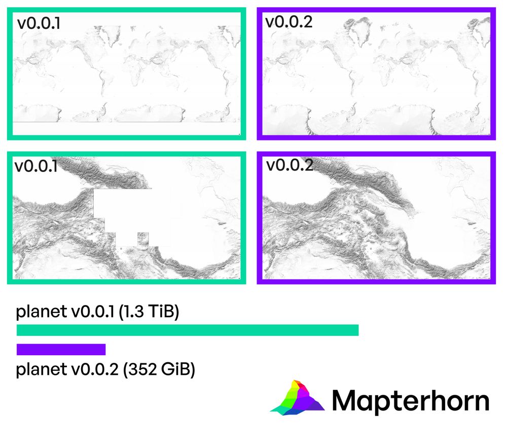
Mapterhorn v0.0.5 was released: Sweden, Poland, The Netherlands, Sicily, and parts of Sardinia got high-resolution terrain data.
Total PMTiles file size: 2.6 TiB.
The raw source data is now also available for download (2.9 TiB).
mapterhorn.com
Enjoy!
Total PMTiles file size: 2.6 TiB.
The raw source data is now also available for download (2.9 TiB).
mapterhorn.com
Enjoy!

November 18, 2025 at 9:12 AM
Mapterhorn v0.0.5 was released: Sweden, Poland, The Netherlands, Sicily, and parts of Sardinia got high-resolution terrain data.
Total PMTiles file size: 2.6 TiB.
The raw source data is now also available for download (2.9 TiB).
mapterhorn.com
Enjoy!
Total PMTiles file size: 2.6 TiB.
The raw source data is now also available for download (2.9 TiB).
mapterhorn.com
Enjoy!
Cloudflare is supporting Mapterhorn with free unlimited R2 Object Storage, Workers invocations, and bandwidth. Thank-You, Cloudflare!
This allows us to operate a free-to-use and unrestricted single tile HTTP endpoint. Migration instructions: mapterhorn.com/examples/mig...
This allows us to operate a free-to-use and unrestricted single tile HTTP endpoint. Migration instructions: mapterhorn.com/examples/mig...
October 27, 2025 at 6:59 AM
Cloudflare is supporting Mapterhorn with free unlimited R2 Object Storage, Workers invocations, and bandwidth. Thank-You, Cloudflare!
This allows us to operate a free-to-use and unrestricted single tile HTTP endpoint. Migration instructions: mapterhorn.com/examples/mig...
This allows us to operate a free-to-use and unrestricted single tile HTTP endpoint. Migration instructions: mapterhorn.com/examples/mig...
Mapterhorn v0.0.4 ships high-resolution terrain data for Belgium, Czech Republic, Denmark, Estonia, Finland, France, Germany, Italy, Latvia, Luxembourg, Romania, Slovakia, Slovenia, and Spain.
Explore the map at mapterhorn.com/viewer/#map=...
Explore the map at mapterhorn.com/viewer/#map=...
October 20, 2025 at 8:27 AM
Mapterhorn v0.0.4 ships high-resolution terrain data for Belgium, Czech Republic, Denmark, Estonia, Finland, France, Germany, Italy, Latvia, Luxembourg, Romania, Slovakia, Slovenia, and Spain.
Explore the map at mapterhorn.com/viewer/#map=...
Explore the map at mapterhorn.com/viewer/#map=...
Version 0.0.3 brings high-resolution data for Austria. Country-wide 10 m data is used, on top of which higher resolution data was layered: 5 m for Burgenland, 1 m or better for Salzburg, Oberösterreich, and Kärnten.
Enjoy the Austria data!
github.com/mapterhorn/m...
Enjoy the Austria data!
github.com/mapterhorn/m...

September 5, 2025 at 7:23 AM
Version 0.0.3 brings high-resolution data for Austria. Country-wide 10 m data is used, on top of which higher resolution data was layered: 5 m for Burgenland, 1 m or better for Salzburg, Oberösterreich, and Kärnten.
Enjoy the Austria data!
github.com/mapterhorn/m...
Enjoy the Austria data!
github.com/mapterhorn/m...
Mapterhorn v0.0.2 ships smaller tiles that are optimized for size while keeping the same visual quality, missing data in Caucasus and polar regions were added, and you can now use the pmtiles cli tool to make small area extracts.
mapterhorn.com
mapterhorn.com
August 20, 2025 at 11:24 AM
Mapterhorn v0.0.2 ships smaller tiles that are optimized for size while keeping the same visual quality, missing data in Caucasus and polar regions were added, and you can now use the pmtiles cli tool to make small area extracts.
mapterhorn.com
mapterhorn.com
Mapterhorn v0.0.1 has been released. It is an aggregation of the global Copernicus GLO-30 low-resolution digital elevation model with the Swiss swissALTI3D high-resolution model. mapterhorn.com
mapterhorn
Open terrain tile sets and data catalog
mapterhorn.com
August 8, 2025 at 3:32 PM
Mapterhorn v0.0.1 has been released. It is an aggregation of the global Copernicus GLO-30 low-resolution digital elevation model with the Swiss swissALTI3D high-resolution model. mapterhorn.com