


Scott Milne (Milne Technologies)
@milnetechnologies.ca
Fisheries Acoustics, Aquatic Habitat Mapping, Fish Impingement Monitoring, #Sonar Imaging and Acoustic Biotelemetry. https://www.youtube.com/channel/UCF8gJF1PjC6i6bWB5icJB9A www.milnetechnologies.ca
#Hydroacoustics #Multibeam #FishTracking #Hydrography
#Hydroacoustics #Multibeam #FishTracking #Hydrography
Pinned

Wanna learn more about what we do? Have a look at some of the #hydroacoustic services we provide. Our promo doc includes clickable links to videos, echograms, case studies and examples. Thx for check'n it out! 📌
www.milnetechnologies.ca/MilneTech_Do...
www.milnetechnologies.ca/MilneTech_Do...
Wishing you calm seas @alltooclearfilm.bsky.social! In partnership with @harknesslab.bsky.social and @lakeheaduniversity.bsky.social, we will be sinking an autonomous up-looking echosounder that will ping 24/7 to help understand the diel behaviour of fish and zoop at Sup Shoal. Be sure to tune in!
Pre-dawn departure from Duluth - steaming for 24 hours to get to the Superior Shoal. @CTVLondon picked up the story, check it out:
www.ctvnews.ca/london/artic...
See the Superior Shoal for yourself on the LIVEstream this Sunday 3-5pm ET. www.youtube.com/live/oKB_iw8...
www.ctvnews.ca/london/artic...
See the Superior Shoal for yourself on the LIVEstream this Sunday 3-5pm ET. www.youtube.com/live/oKB_iw8...

Bruce County filmmakers searching Great Lake for ‘Freshwater Everest’
The research vessel, Blue Heron, left Duluth this morning, steaming towards a once in a lifetime underwater research opportunity in Lake Superior.
www.ctvnews.ca
September 10, 2025 at 1:24 PM
Wishing you calm seas @alltooclearfilm.bsky.social! In partnership with @harknesslab.bsky.social and @lakeheaduniversity.bsky.social, we will be sinking an autonomous up-looking echosounder that will ping 24/7 to help understand the diel behaviour of fish and zoop at Sup Shoal. Be sure to tune in!
Reposted by Scott Milne (Milne Technologies)

📡 Smart fisheries management!
A solar-powered, acoustic monitoring system is providing near-real-time fish abundance data to optimize fishing for sustainability. 🐟
IJMS Hidden Gems
🎬 Watch now youtu.be/7EJhpwAqLJo
Full study ➡️https://doi.org/10.1093/icesjms/fsad196
📷Mark Stone @uwsafs.bsky.social
A solar-powered, acoustic monitoring system is providing near-real-time fish abundance data to optimize fishing for sustainability. 🐟
IJMS Hidden Gems
🎬 Watch now youtu.be/7EJhpwAqLJo
Full study ➡️https://doi.org/10.1093/icesjms/fsad196
📷Mark Stone @uwsafs.bsky.social

March 17, 2025 at 4:25 PM
📡 Smart fisheries management!
A solar-powered, acoustic monitoring system is providing near-real-time fish abundance data to optimize fishing for sustainability. 🐟
IJMS Hidden Gems
🎬 Watch now youtu.be/7EJhpwAqLJo
Full study ➡️https://doi.org/10.1093/icesjms/fsad196
📷Mark Stone @uwsafs.bsky.social
A solar-powered, acoustic monitoring system is providing near-real-time fish abundance data to optimize fishing for sustainability. 🐟
IJMS Hidden Gems
🎬 Watch now youtu.be/7EJhpwAqLJo
Full study ➡️https://doi.org/10.1093/icesjms/fsad196
📷Mark Stone @uwsafs.bsky.social
Reposted by Scott Milne (Milne Technologies)

Measuring travel time and knowing the speed of sound in water, the echosounder provides depth measurements along swaths, which we combine to create bathymetric maps, revealing underwater landscapes, submarine volcanoes, and ridges.

January 19, 2025 at 12:02 PM
Measuring travel time and knowing the speed of sound in water, the echosounder provides depth measurements along swaths, which we combine to create bathymetric maps, revealing underwater landscapes, submarine volcanoes, and ridges.
Reposted by Scott Milne (Milne Technologies)

A pretty solid read if you want to learn about CRS’s and the difference between a foot and a survey foot.

Get ready, datums are changing!
Great storymap showing how the effect of the changes!
storymaps.arcgis.com/stories/a8e9...
#GISChat
Great storymap showing how the effect of the changes!
storymaps.arcgis.com/stories/a8e9...
#GISChat

Surveyors Prepare: Datums are Changing!
Better Data Quality Coming to a Location Near You
storymaps.arcgis.com
January 18, 2025 at 4:51 AM
A pretty solid read if you want to learn about CRS’s and the difference between a foot and a survey foot.
Reposted by Scott Milne (Milne Technologies)
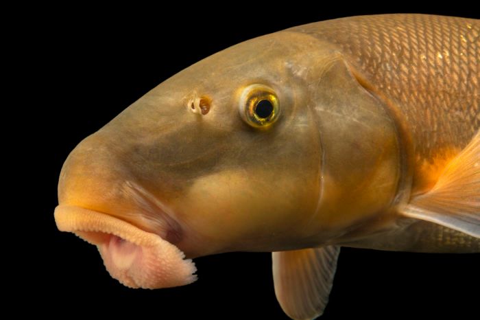
The future is #catostomidae... firmly believe that if there's a sentinel species that can tell us about enironmental changes, this group of fishes is it. Widely distributed, rarely targeted by anglers (and therefore don't need to worry about fishing mortality), and, I mean, just look at that face
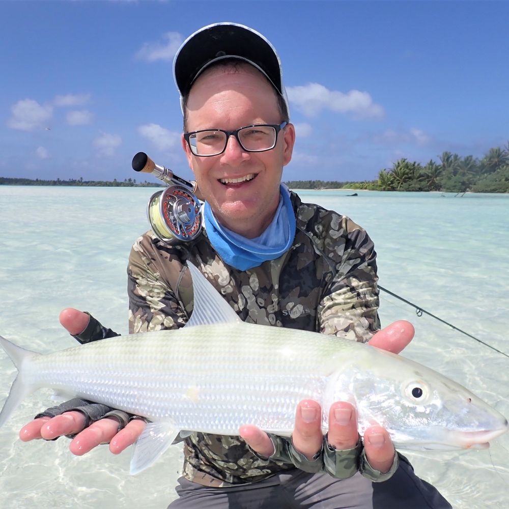
There's a sucker (myth) born every minute. These are not trash fish.
Suckers are native fishes found across N. America. They are essential parts of the ecosystem. They're cool fishes to pursue.
Photo by Joel Sartore, of a largescale sucker I caught for him to photograph (and release).
Suckers are native fishes found across N. America. They are essential parts of the ecosystem. They're cool fishes to pursue.
Photo by Joel Sartore, of a largescale sucker I caught for him to photograph (and release).
January 10, 2025 at 11:33 PM
The future is #catostomidae... firmly believe that if there's a sentinel species that can tell us about enironmental changes, this group of fishes is it. Widely distributed, rarely targeted by anglers (and therefore don't need to worry about fishing mortality), and, I mean, just look at that face
Reposted by Scott Milne (Milne Technologies)
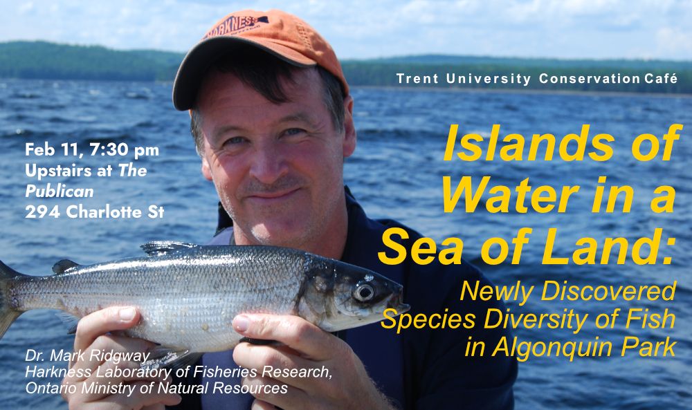
We're back in February for more conservation science! Join Dr. Mark Ridgway for the scoop on Algonquin Park lake fish. There's more going on beneath the waters than we thought!
January 9, 2025 at 3:39 PM
We're back in February for more conservation science! Join Dr. Mark Ridgway for the scoop on Algonquin Park lake fish. There's more going on beneath the waters than we thought!
Reposted by Scott Milne (Milne Technologies)

📣 Just published in @conphysjournal.bsky.social with @jacobbowman.bsky.social, Chris Wilson, and Graham Raby
How much does upper thermal tolerance vary among wild populations of brook trout? What drives this variation? 🌡️
🧵1/5
doi.org/10.1093/conp...
How much does upper thermal tolerance vary among wild populations of brook trout? What drives this variation? 🌡️
🧵1/5
doi.org/10.1093/conp...
Local conditions drive interpopulation variation in field-based critical thermal maximum of brook trout
Abstract. Individual- and population-level responses to thermal change will be pivotal for species’ resilience and adaptive responses to climate change. Th
doi.org
January 8, 2025 at 6:30 PM
📣 Just published in @conphysjournal.bsky.social with @jacobbowman.bsky.social, Chris Wilson, and Graham Raby
How much does upper thermal tolerance vary among wild populations of brook trout? What drives this variation? 🌡️
🧵1/5
doi.org/10.1093/conp...
How much does upper thermal tolerance vary among wild populations of brook trout? What drives this variation? 🌡️
🧵1/5
doi.org/10.1093/conp...
Reposted by Scott Milne (Milne Technologies)
This is why we turned on our multibeam sonar, which measures bathymetry at high resolution (~50 m/pixel) along the track of the ship, revealing spectacular highs and lows as we crossed the Southwest Indian Ridge a couple days ago.

January 1, 2025 at 4:46 AM
This is why we turned on our multibeam sonar, which measures bathymetry at high resolution (~50 m/pixel) along the track of the ship, revealing spectacular highs and lows as we crossed the Southwest Indian Ridge a couple days ago.
Reposted by Scott Milne (Milne Technologies)
Quote: "This situation shows why it's a bit of a risky proposition … to be relying on the industry to collect data that you're using to assess the fishery and then make decisions about how much quota the industry can take."

Industry withholding #data on one of #Canada 's largest #fisheries, advocates say
www.cbc.ca/news/canada/...
www.cbc.ca/news/canada/...

Industry withholding data on one of Canada's largest fisheries, advocates say | CBC News
Advocates and scientists are raising concerns with the availability of data on one of Canada's largest fisheries, as the Department of Fisheries and Oceans DFO is waiting on industry to provide data o...
www.cbc.ca
December 26, 2024 at 7:59 PM
Quote: "This situation shows why it's a bit of a risky proposition … to be relying on the industry to collect data that you're using to assess the fishery and then make decisions about how much quota the industry can take."
Reposted by Scott Milne (Milne Technologies)
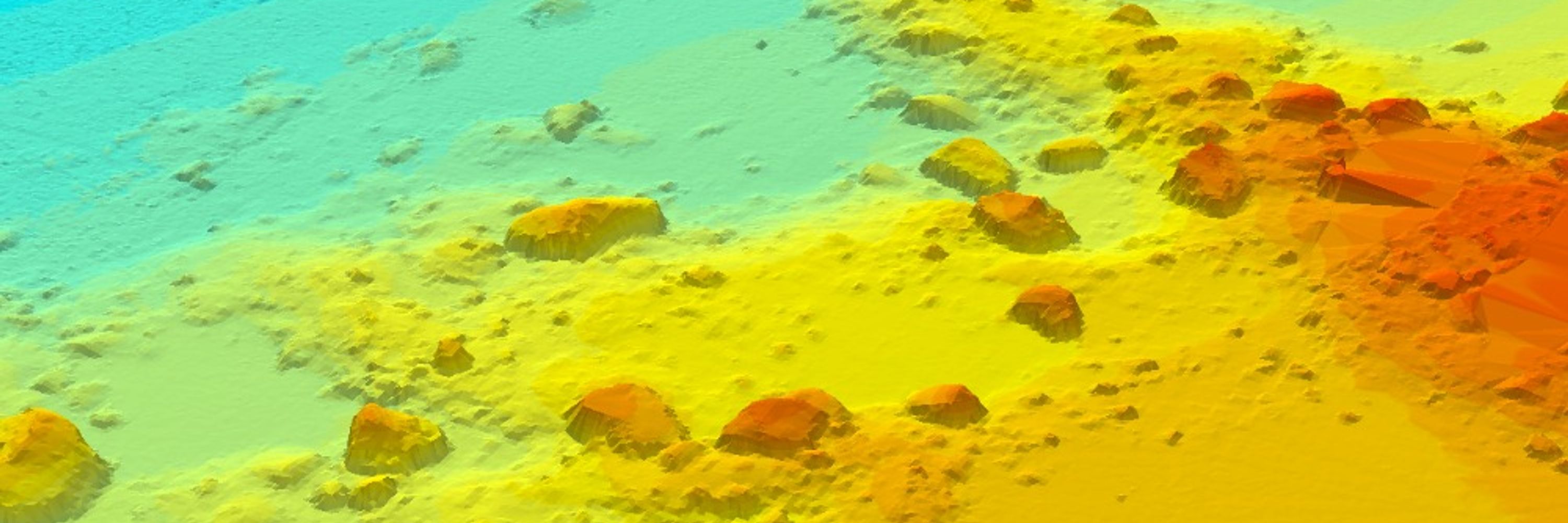
☃️🎼Do you hear what I hear?......at 500 kHz? 🎧 Here is to a safe and "sounding" holiday for you and yours!🎄❄️
Credit: slightly modified bathy model from our 2017 multibeam #sonar survey of @iisd.bsky.social ELA LK260. #ThrowbackThursday
Credit: slightly modified bathy model from our 2017 multibeam #sonar survey of @iisd.bsky.social ELA LK260. #ThrowbackThursday
December 19, 2024 at 5:03 PM
☃️🎼Do you hear what I hear?......at 500 kHz? 🎧 Here is to a safe and "sounding" holiday for you and yours!🎄❄️
Credit: slightly modified bathy model from our 2017 multibeam #sonar survey of @iisd.bsky.social ELA LK260. #ThrowbackThursday
Credit: slightly modified bathy model from our 2017 multibeam #sonar survey of @iisd.bsky.social ELA LK260. #ThrowbackThursday
Reposted by Scott Milne (Milne Technologies)
I’m pleased to share the new version 5 of “The International Bathymetric Chart of the Arctic Ocean (IBCAO)”, which offers a resolution (100 × 100 m) four times as high as v4:
rdcu.be/d4yx7
#OceanMapping #seafloor #geomorphology ⚒️🌊
rdcu.be/d4yx7
#OceanMapping #seafloor #geomorphology ⚒️🌊

The International Bathymetric Chart of the Arctic Ocean Version 5.0
Scientific Data - The International Bathymetric Chart of the Arctic Ocean Version 5.0
rdcu.be
December 23, 2024 at 3:28 PM
I’m pleased to share the new version 5 of “The International Bathymetric Chart of the Arctic Ocean (IBCAO)”, which offers a resolution (100 × 100 m) four times as high as v4:
rdcu.be/d4yx7
#OceanMapping #seafloor #geomorphology ⚒️🌊
rdcu.be/d4yx7
#OceanMapping #seafloor #geomorphology ⚒️🌊
Reposted by Scott Milne (Milne Technologies)
Fish Distribution in Lacustrine and Riverine Biotopes of Bratsk Reservoir Based on the Results of Hydroacoustic Surveys. J. Ichthyol. 64, 1001–1015 (2024). doi.org/10.1134/S003...

Fish Distribution in Lacustrine and Riverine Biotopes of Bratsk Reservoir Based on the Results of Hydroacoustic Surveys - Journal of Ichthyology
Abstract Fish distribution in different areas of Bratsk Reservoir has been studied using hydroacoustic equipment. The average abundance of fish decreases (r = –0.70; p < 0.05; R2 = 0.49) from the near...
doi.org
December 20, 2024 at 9:50 PM
Fish Distribution in Lacustrine and Riverine Biotopes of Bratsk Reservoir Based on the Results of Hydroacoustic Surveys. J. Ichthyol. 64, 1001–1015 (2024). doi.org/10.1134/S003...
☃️🎼Do you hear what I hear?......at 500 kHz? 🎧 Here is to a safe and "sounding" holiday for you and yours!🎄❄️
Credit: slightly modified bathy model from our 2017 multibeam #sonar survey of @iisd.bsky.social ELA LK260. #ThrowbackThursday
Credit: slightly modified bathy model from our 2017 multibeam #sonar survey of @iisd.bsky.social ELA LK260. #ThrowbackThursday
December 19, 2024 at 5:03 PM
☃️🎼Do you hear what I hear?......at 500 kHz? 🎧 Here is to a safe and "sounding" holiday for you and yours!🎄❄️
Credit: slightly modified bathy model from our 2017 multibeam #sonar survey of @iisd.bsky.social ELA LK260. #ThrowbackThursday
Credit: slightly modified bathy model from our 2017 multibeam #sonar survey of @iisd.bsky.social ELA LK260. #ThrowbackThursday
Alewife in the #GreatLakes are sensitive to seiche-driven upwelling events, forcing large schools to go tight to shore. Implications for potential fish entrainment at cooling-water intake facilities. Results from a fish diversion system monitoring study using #acoustics. 🐟
doi.org/10.1080/0275...
doi.org/10.1080/0275...
December 18, 2024 at 8:32 PM
Alewife in the #GreatLakes are sensitive to seiche-driven upwelling events, forcing large schools to go tight to shore. Implications for potential fish entrainment at cooling-water intake facilities. Results from a fish diversion system monitoring study using #acoustics. 🐟
doi.org/10.1080/0275...
doi.org/10.1080/0275...
An example of upstream migrating Whitefish in a #GreatLakes tributary recorded using a #DIDSON multibeam imaging #sonar. The video provides a demo of our semi-automated processing method using Echoview software. We also support ARIS and FlexView sonar data. Methods paper; doi.org/10.1016/j.fi...
December 17, 2024 at 4:36 PM
An example of upstream migrating Whitefish in a #GreatLakes tributary recorded using a #DIDSON multibeam imaging #sonar. The video provides a demo of our semi-automated processing method using Echoview software. We also support ARIS and FlexView sonar data. Methods paper; doi.org/10.1016/j.fi...
Reposted by Scott Milne (Milne Technologies)

A Walk in the Snow
Jennifer Walton
2016
Jennifer Walton
2016

December 16, 2024 at 10:32 PM
A Walk in the Snow
Jennifer Walton
2016
Jennifer Walton
2016
Imaging #sonar systems such as #ARIS are ideal for observing fish behaviour and for assessing spawning sites. Shown are spawning fish within a #GreatLakes coastal wetland. We use Echoview software to automate background removal, target detection, and counting. Methods paper; doi.org/10.1002/nafm...
December 13, 2024 at 10:55 PM
Imaging #sonar systems such as #ARIS are ideal for observing fish behaviour and for assessing spawning sites. Shown are spawning fish within a #GreatLakes coastal wetland. We use Echoview software to automate background removal, target detection, and counting. Methods paper; doi.org/10.1002/nafm...
Reposted by Scott Milne (Milne Technologies)

🔥 🔥 🔥 New Version🔥 🔥 🔥
#PINGMapper is now compatible with Lowrance fishfinders!
github.com/CameronBodin...
#CSHEL #sidescan #fishfinders4good #benthicmapping
#PINGMapper is now compatible with Lowrance fishfinders!
github.com/CameronBodin...
#CSHEL #sidescan #fishfinders4good #benthicmapping

GitHub - CameronBodine/PINGMapper: Open-source interface for processing recreation-grade side scan sonar datasets and reproducibly mapping benthic habitat
Open-source interface for processing recreation-grade side scan sonar datasets and reproducibly mapping benthic habitat - CameronBodine/PINGMapper
github.com
December 12, 2024 at 1:16 PM
🔥 🔥 🔥 New Version🔥 🔥 🔥
#PINGMapper is now compatible with Lowrance fishfinders!
github.com/CameronBodin...
#CSHEL #sidescan #fishfinders4good #benthicmapping
#PINGMapper is now compatible with Lowrance fishfinders!
github.com/CameronBodin...
#CSHEL #sidescan #fishfinders4good #benthicmapping
Reposted by Scott Milne (Milne Technologies)
In addition, new methods of reading data from sonar logs (recordings) result in up to a 1.3𝐱 𝐬𝐩𝐞𝐞𝐝𝐮𝐩!
Head over to GitHub to try it out! Happy ping-ing!
Head over to GitHub to try it out! Happy ping-ing!
December 12, 2024 at 1:16 PM
In addition, new methods of reading data from sonar logs (recordings) result in up to a 1.3𝐱 𝐬𝐩𝐞𝐞𝐝𝐮𝐩!
Head over to GitHub to try it out! Happy ping-ing!
Head over to GitHub to try it out! Happy ping-ing!
Do you have piles of Zip or CD-R disks tucked away that hold old DGN, DT4, ECH or SMP survey data?💾💽
Want to know what your lake looked like “back in the day”?
We can reprocess your vintage echogram data files using the latest software. We support legacy formats from Simrad, BioSonics and HTI. 💻🔊🐟
Want to know what your lake looked like “back in the day”?
We can reprocess your vintage echogram data files using the latest software. We support legacy formats from Simrad, BioSonics and HTI. 💻🔊🐟

December 10, 2024 at 4:30 PM
Do you have piles of Zip or CD-R disks tucked away that hold old DGN, DT4, ECH or SMP survey data?💾💽
Want to know what your lake looked like “back in the day”?
We can reprocess your vintage echogram data files using the latest software. We support legacy formats from Simrad, BioSonics and HTI. 💻🔊🐟
Want to know what your lake looked like “back in the day”?
We can reprocess your vintage echogram data files using the latest software. We support legacy formats from Simrad, BioSonics and HTI. 💻🔊🐟
Reposted by Scott Milne (Milne Technologies)

#ASA187 Lay Language Paper
The Trump Rally Shooting: Listening to an Assassination Attempt
acoustics.org/the-tr...
The Trump Rally Shooting: Listening to an Assassination Attempt
acoustics.org/the-tr...

The Trump Rally Shooting: Listening to an Assassination Attempt
When rifle fire interrupted Donald J. Trump’s campaign rally, more than two dozen user-generated recordings allowed rapid audio forensic interpretation.
acoustics.org
December 9, 2024 at 2:09 PM
#ASA187 Lay Language Paper
The Trump Rally Shooting: Listening to an Assassination Attempt
acoustics.org/the-tr...
The Trump Rally Shooting: Listening to an Assassination Attempt
acoustics.org/the-tr...
Reposted by Scott Milne (Milne Technologies)
Calling #Acousticians! Submit your abstract for the joint ASA/ICA Meeting! Dive into special sessions, from Acoustic Ecology to Animal Vocal Communication & more. Showcase your work in New Orleans, Louisiana! Abstracts due Jan 6—don’t miss out! Details at acousticalsociety.or...
December 5, 2024 at 10:00 PM
Calling #Acousticians! Submit your abstract for the joint ASA/ICA Meeting! Dive into special sessions, from Acoustic Ecology to Animal Vocal Communication & more. Showcase your work in New Orleans, Louisiana! Abstracts due Jan 6—don’t miss out! Details at acousticalsociety.or...
Reposted by Scott Milne (Milne Technologies)
Yesterday was our final day of tagging spawning lake whitefish on Lake Simcoe. We will be tracking the movements of these fish around the lake.

December 4, 2024 at 5:06 PM
Yesterday was our final day of tagging spawning lake whitefish on Lake Simcoe. We will be tracking the movements of these fish around the lake.
Reposted by Scott Milne (Milne Technologies)
Are you a fish telemetry practitioner? The 7th International Conference on Fish Telemetry will take place June 8-13, 2025 in Traverse City, Michigan, USA. The conference website is now live for abstract submission and details on the venue. Help spread the word. event.fourwaves.com/7thicft/pages

International Conference on Fish Telemetry (7th ICFT)
Fourwaves - International Conference on Fish Telemetry (7th ICFT)
event.fourwaves.com
December 4, 2024 at 3:31 PM
Are you a fish telemetry practitioner? The 7th International Conference on Fish Telemetry will take place June 8-13, 2025 in Traverse City, Michigan, USA. The conference website is now live for abstract submission and details on the venue. Help spread the word. event.fourwaves.com/7thicft/pages
Wanna learn more about what we do? Have a look at some of the #hydroacoustic services we provide. Our promo doc includes clickable links to videos, echograms, case studies and examples. Thx for check'n it out! 📌
www.milnetechnologies.ca/MilneTech_Do...
www.milnetechnologies.ca/MilneTech_Do...
December 2, 2024 at 8:09 PM
Wanna learn more about what we do? Have a look at some of the #hydroacoustic services we provide. Our promo doc includes clickable links to videos, echograms, case studies and examples. Thx for check'n it out! 📌
www.milnetechnologies.ca/MilneTech_Do...
www.milnetechnologies.ca/MilneTech_Do...