


Morgan Laidler
@morganlaidler.bsky.social
I’m here for the weather.
President and CEO of the #YegWeatherDome
President and CEO of the #YegWeatherDome
The update for Wednesday, and there’s a lot going on.
We got that system that’s going to sweep through NW AB down into southern Man. Snowfall warnings with winter storm watches and warnings are in place.
Extreme cold windchill in the North.
#yegwx #abstorm #skstorm #mbstorm
We got that system that’s going to sweep through NW AB down into southern Man. Snowfall warnings with winter storm watches and warnings are in place.
Extreme cold windchill in the North.
#yegwx #abstorm #skstorm #mbstorm

December 16, 2025 at 3:57 PM
A yellow level snowfall warning has been issued from Grande Prairie down to Edmonton as the area could 10-20cm by Wednesday evening.
A winter storm warning has been issued for areas just to the SE of Edmonton down to the Sask border. 10-20cm with high winds.
#abstorm #yegwx
A winter storm warning has been issued for areas just to the SE of Edmonton down to the Sask border. 10-20cm with high winds.
#abstorm #yegwx


December 16, 2025 at 2:16 PM

December 16, 2025 at 3:34 AM
A yellow level flash freeze warning is in effect for portions of central and eastern AB as we’ll see rapid freezing into the -15°C area by sunrise. A temp inversion will still make any precip to fall as freezing rain.
A wind warning still in effect for SE AB.
#abstorm #yegwx
A wind warning still in effect for SE AB.
#abstorm #yegwx


December 16, 2025 at 3:10 AM


Yellow level advisory issued for portions of southeastern due to snow and winds gusting to 60 km/h causing blowing snow and poor visibility Thursday morning.
Also, a yellow level warning for snowfall in the SE corner of the province as 15cm is possible.
#abstorm #abroads
Also, a yellow level warning for snowfall in the SE corner of the province as 15cm is possible.
#abstorm #abroads


December 10, 2025 at 10:52 PM
Freezing rain coming though the city and it’s due to a temperature inversion. It’s about -11°C on the surface while about 500m up it’s 8°C causing rain to fall and not snow.
A warning in place for freezing rain.
#yegwx
A warning in place for freezing rain.
#yegwx


December 9, 2025 at 5:23 AM
Freezing rain coming though the city and it’s due to a temperature inversion. It’s about -11°C on the surface while about 500m up it’s 8°C causing rain to fall and not snow.
A warning in place for freezing rain.
#yegwx
A warning in place for freezing rain.
#yegwx
December 1, 2025 at 6:39 PM
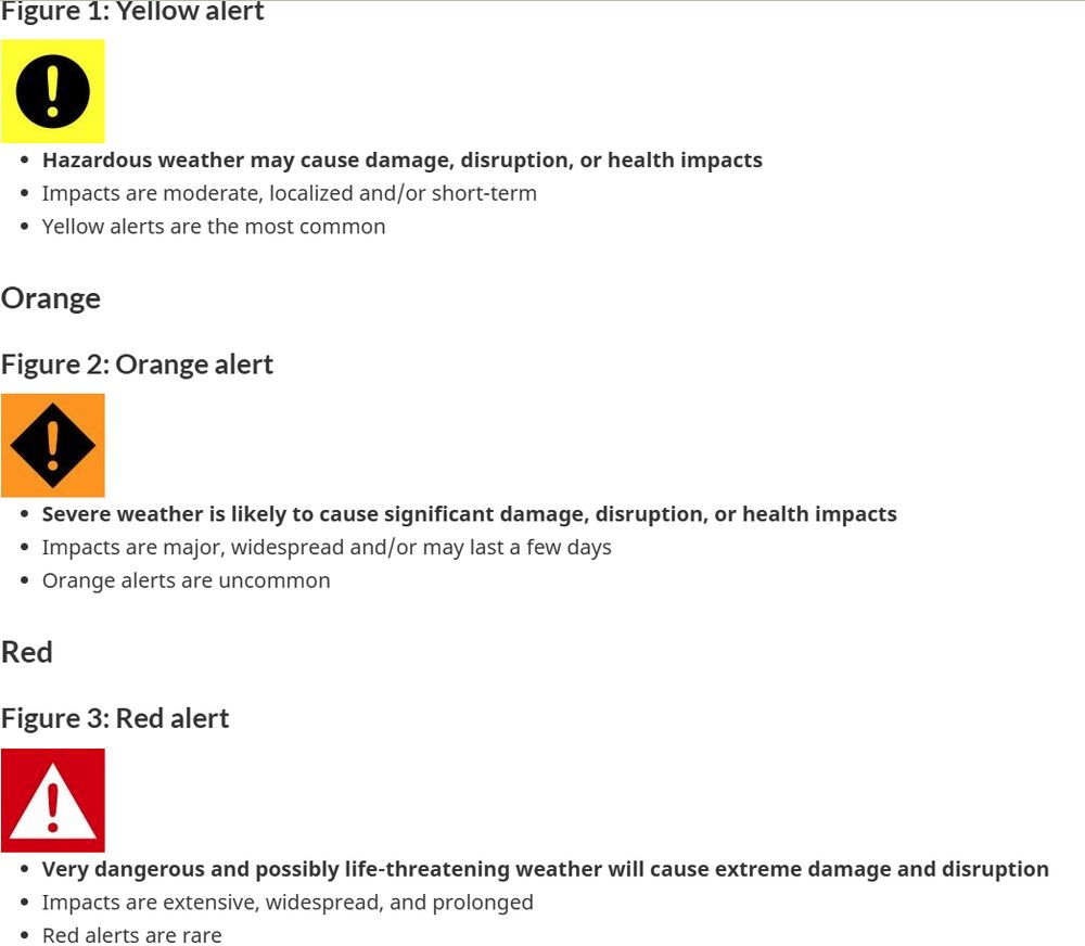
It's gonna take a while to get used to this new alert system in Canada.
Gone are the defined warning criterias. They have been replaced with alerts from yellow to red depending on the impact and confidence of each.
Click the link to learn more.
www.canada.ca/en/services/...
Gone are the defined warning criterias. They have been replaced with alerts from yellow to red depending on the impact and confidence of each.
Click the link to learn more.
www.canada.ca/en/services/...

November 26, 2025 at 8:15 PM
It's gonna take a while to get used to this new alert system in Canada.
Gone are the defined warning criterias. They have been replaced with alerts from yellow to red depending on the impact and confidence of each.
Click the link to learn more.
www.canada.ca/en/services/...
Gone are the defined warning criterias. They have been replaced with alerts from yellow to red depending on the impact and confidence of each.
Click the link to learn more.
www.canada.ca/en/services/...


November 26, 2025 at 7:47 PM


November 12, 2025 at 4:07 AM
Not a bad forecast for this week, a couple fairly cold overnight's and we're getting some precip Wednesday night into Thursday as we'll see rain change to periods of snow.
We'll know more about totals as we get closer but as of right now we could be around 5cm.
#yegwx
We'll know more about totals as we get closer but as of right now we could be around 5cm.
#yegwx

November 3, 2025 at 6:58 PM
Not a bad forecast for this week, a couple fairly cold overnight's and we're getting some precip Wednesday night into Thursday as we'll see rain change to periods of snow.
We'll know more about totals as we get closer but as of right now we could be around 5cm.
#yegwx
We'll know more about totals as we get closer but as of right now we could be around 5cm.
#yegwx
It's your 👻Halloween 🎃forecast.
Temps remaining consistent throughout the day (between 10-8°C) but wind will pick up this evening as we could see southerly winds of 30 gusting to 50.
#yegwx
Temps remaining consistent throughout the day (between 10-8°C) but wind will pick up this evening as we could see southerly winds of 30 gusting to 50.
#yegwx

October 31, 2025 at 2:56 PM
It's your 👻Halloween 🎃forecast.
Temps remaining consistent throughout the day (between 10-8°C) but wind will pick up this evening as we could see southerly winds of 30 gusting to 50.
#yegwx
Temps remaining consistent throughout the day (between 10-8°C) but wind will pick up this evening as we could see southerly winds of 30 gusting to 50.
#yegwx
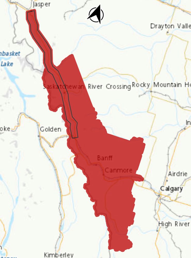
It’s that time of year again!
Snowfall warning has been issued for the Banff, Kananaskis, Sheep River Provincial park and highway 93 (Icefields Parkway).
Rain changing to snow, 5-20cm expected by Saturday night.
#abstorm
Snowfall warning has been issued for the Banff, Kananaskis, Sheep River Provincial park and highway 93 (Icefields Parkway).
Rain changing to snow, 5-20cm expected by Saturday night.
#abstorm

October 10, 2025 at 9:44 PM
It’s that time of year again!
Snowfall warning has been issued for the Banff, Kananaskis, Sheep River Provincial park and highway 93 (Icefields Parkway).
Rain changing to snow, 5-20cm expected by Saturday night.
#abstorm
Snowfall warning has been issued for the Banff, Kananaskis, Sheep River Provincial park and highway 93 (Icefields Parkway).
Rain changing to snow, 5-20cm expected by Saturday night.
#abstorm

October 8, 2025 at 9:35 PM


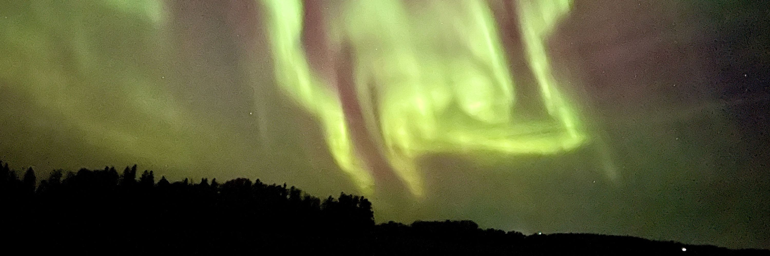
Hello Orion, my old friend.
It’s great to see you again.
Best viewed when the lights are turned out.
Your return in fall is never in doubt.
I know Bruce would’ve liked this tweet.
I miss him.
It’s great to see you again.
Best viewed when the lights are turned out.
Your return in fall is never in doubt.
I know Bruce would’ve liked this tweet.
I miss him.

October 2, 2025 at 6:07 PM
Hello Orion, my old friend.
It’s great to see you again.
Best viewed when the lights are turned out.
Your return in fall is never in doubt.
I know Bruce would’ve liked this tweet.
I miss him.
It’s great to see you again.
Best viewed when the lights are turned out.
Your return in fall is never in doubt.
I know Bruce would’ve liked this tweet.
I miss him.