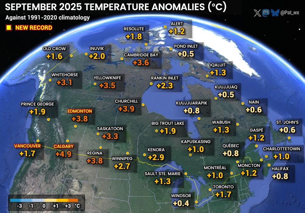

Full article: Linking Marine Fog Variability in Atlantic Canada to Changes in Large-Scale Atmospheric and Marine Features www.tandfonline.com/doi/full/10....

Full article: Linking Marine Fog Variability in Atlantic Canada to Changes in Large-Scale Atmospheric and Marine Features www.tandfonline.com/doi/full/10....
The average date of first -30° in Eureka for 1991-2020 is Oct 21.


The average date of first -30° in Eureka for 1991-2020 is Oct 21.
Record-warmest October for:
Cambridge Bay -2.5° (previously -2.9 in 2021/2023)
Churchill 4.7° (4.0 in 2021)
Kuujjuaq 5.4° (3.8 in 2021)
Nain 7.1° (5.3 in 2023)
Wabush 4.9° (4.8 in 2022)

Record-warmest October for:
Cambridge Bay -2.5° (previously -2.9 in 2021/2023)
Churchill 4.7° (4.0 in 2021)
Kuujjuaq 5.4° (3.8 in 2021)
Nain 7.1° (5.3 in 2023)
Wabush 4.9° (4.8 in 2022)

A few missed records:
Ottawa 29.9° (1.0° from record of 2023)
Quebec City 26.7° (1.6° from record of 1949)
Moosonee 29.0° (1.0° from record of 2023)

A few missed records:
Ottawa 29.9° (1.0° from record of 2023)
Quebec City 26.7° (1.6° from record of 1949)
Moosonee 29.0° (1.0° from record of 2023)


30.3° Havre-Saint-Pierre, QC (previously 30,0° 1987/07/14)
36.3° (prelim.) in Goose Bay: New August Labrador record!
Very impressive 35.7° in Cartwright, too! August record for the station. #NLwx

30.3° Havre-Saint-Pierre, QC (previously 30,0° 1987/07/14)
36.3° (prelim.) in Goose Bay: New August Labrador record!
Very impressive 35.7° in Cartwright, too! August record for the station. #NLwx
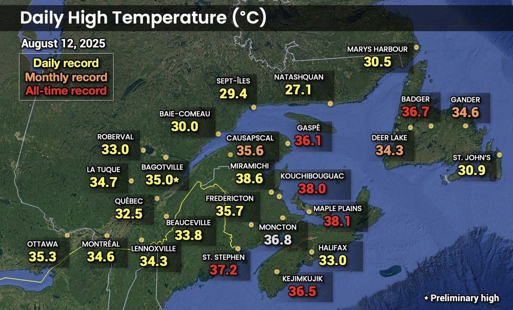
All-time records were set at several stations, and the all-time PEI record was shattered with 38.1° at Maple Plains!
36.7° in Badger, NL tied August record for NL and all-time record for the island. 38.6° in Miramichi is 0.8° below NB all-time record. ♨️

All-time records were set at several stations, and the all-time PEI record was shattered with 38.1° at Maple Plains!
36.7° in Badger, NL tied August record for NL and all-time record for the island. 38.6° in Miramichi is 0.8° below NB all-time record. ♨️


Previous was 105.00 kPa on Feb. 13, 1981.
December records are also broken today in much of eastern ON and western QC, including Montreal and Quebec City.

Previous was 105.00 kPa on Feb. 13, 1981.
December records are also broken today in much of eastern ON and western QC, including Montreal and Quebec City.
14,1° à Cartwright: Température la plus haute jamais enregistrée au Labrador en décembre.
Au Québec: Jusqu'à 16,7° à Cap-Chat.
À Terre-Neuve: 18,1° à Daniel's Harbour!


14,1° à Cartwright: Température la plus haute jamais enregistrée au Labrador en décembre.
Au Québec: Jusqu'à 16,7° à Cap-Chat.
À Terre-Neuve: 18,1° à Daniel's Harbour!
Bilan final pour la majorité du sud/centre, bilan partiel dans l'est.
Beaucoup de variation à travers le Grand Montréal, avec 5 cm à l'aéroport et 13 cm au centre-ville.
Laurentides jusqu'à 30 cm, et plus de 30 cm dans Charlevoix et autour de Forestville.

Bilan final pour la majorité du sud/centre, bilan partiel dans l'est.
Beaucoup de variation à travers le Grand Montréal, avec 5 cm à l'aéroport et 13 cm au centre-ville.
Laurentides jusqu'à 30 cm, et plus de 30 cm dans Charlevoix et autour de Forestville.


