


Pete Bouchard
@petebouchard.bsky.social
Chief Meteorologist at NBC Boston. ☀️🌧️⚡️🌪️❄️💨
Lenticular clouds above Mt. Washington today. Completely harmless, they form when stable air is forced to rise over a mountain range. Note the striking resemblance to “mothership” supercell thunderstorms - which can be precursors for tornadoes.


November 26, 2025 at 1:44 AM
Lenticular clouds above Mt. Washington today. Completely harmless, they form when stable air is forced to rise over a mountain range. Note the striking resemblance to “mothership” supercell thunderstorms - which can be precursors for tornadoes.
Logan Airport finally hit the magic mark. 1st 32 of the season this morning. Tough go this year. Came so close several times. Avg is Nov. 5th. Latest is Dec 6th in 2009.

November 20, 2025 at 1:48 PM
Logan Airport finally hit the magic mark. 1st 32 of the season this morning. Tough go this year. Came so close several times. Avg is Nov. 5th. Latest is Dec 6th in 2009.
1st accumulation of the season in Spencer, Mass tonight. Three days later than last year.

November 17, 2025 at 3:06 AM
1st accumulation of the season in Spencer, Mass tonight. Three days later than last year.
Reposted by Pete Bouchard

@petebouchard.bsky.social 26F and gentle snow in the Berkshires (Clarksburg 01247)

November 11, 2025 at 6:20 PM
@petebouchard.bsky.social 26F and gentle snow in the Berkshires (Clarksburg 01247)
Nothing like an early season cold blast to get your attention. Highs only near 40 Tuesday with wind chills in the 20s. 🥶 Not much better in the days ahead.


November 11, 2025 at 4:09 AM
Nothing like an early season cold blast to get your attention. Highs only near 40 Tuesday with wind chills in the 20s. 🥶 Not much better in the days ahead.
Tonight's storm over us will undergo bombogenesis by morning off Cape Breton Island, NS (pic 1). This means more wind Tue. If you're counting, that's two bombs in the Maritime provinces in less than a week...& another by Thu. Real cold pours in next week (pic 2)!


November 4, 2025 at 3:45 AM
Tonight's storm over us will undergo bombogenesis by morning off Cape Breton Island, NS (pic 1). This means more wind Tue. If you're counting, that's two bombs in the Maritime provinces in less than a week...& another by Thu. Real cold pours in next week (pic 2)!
Does this mean winter will be kind to us? Double rainbow over Needham this evening.

October 24, 2025 at 10:44 PM
Does this mean winter will be kind to us? Double rainbow over Needham this evening.
This is the heaviest it will be with this event. Lighter showers after noon, then some clearing by 3p. 🌧️
October 20, 2025 at 3:07 PM
This is the heaviest it will be with this event. Lighter showers after noon, then some clearing by 3p. 🌧️
Few unhappy customers with the rain through midday tomorrow. October air follows.


October 8, 2025 at 2:48 AM
Few unhappy customers with the rain through midday tomorrow. October air follows.
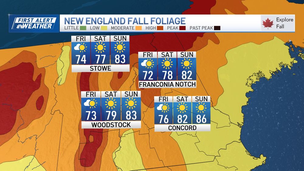
Foliage peaking in Northern New England this weekend! Toasty temps through Tuesday. Sea breezes knock us back a bit at the coast. ☀️

October 3, 2025 at 3:51 AM
Foliage peaking in Northern New England this weekend! Toasty temps through Tuesday. Sea breezes knock us back a bit at the coast. ☀️
Mild weekend ahead. Slight risk of a shower early Sunday. Steady drop in temps next week.


September 26, 2025 at 3:09 AM
Mild weekend ahead. Slight risk of a shower early Sunday. Steady drop in temps next week.
Wrestling with the guidance on how much rain will fall tomorrow. We've thrown our weight behind the European model (pic 1), while the US model isn't so sure (pic 2). European likely picking up on t-storms. (Placement may be off depending on where they form.)


September 24, 2025 at 10:22 PM
Wrestling with the guidance on how much rain will fall tomorrow. We've thrown our weight behind the European model (pic 1), while the US model isn't so sure (pic 2). European likely picking up on t-storms. (Placement may be off depending on where they form.)
I’d like to think this is our best chance at a long, soaking rain in weeks, but model guidance often overplays its hand on days-long rain (and snow) forecasts. We’ll see how it plays out.


September 22, 2025 at 3:42 AM
I’d like to think this is our best chance at a long, soaking rain in weeks, but model guidance often overplays its hand on days-long rain (and snow) forecasts. We’ll see how it plays out.
Fiery sunset in Rutland, MA from Nick Anderson. 🌅

September 17, 2025 at 2:46 AM
Fiery sunset in Rutland, MA from Nick Anderson. 🌅
Final tally was FIVE tornadoes on Saturday afternoon. This ranks as the biggest outbreak since 2011.
September 10, 2025 at 3:26 AM
Final tally was FIVE tornadoes on Saturday afternoon. This ranks as the biggest outbreak since 2011.
The National Weather Service confirms TWO tornadoes touched down in central Mass on Saturday. One in Paxton and one in Holden. Both were EF1 intensity with winds to 86-110mph. Path length and width along with precise timing are pending.


September 8, 2025 at 8:38 PM
The National Weather Service confirms TWO tornadoes touched down in central Mass on Saturday. One in Paxton and one in Holden. Both were EF1 intensity with winds to 86-110mph. Path length and width along with precise timing are pending.
Tied for 11th driest, this (climatological) summer was also almost 2 deg. above normal (but not as hot as last summer).


September 2, 2025 at 12:18 AM
Tied for 11th driest, this (climatological) summer was also almost 2 deg. above normal (but not as hot as last summer).
Massive dust storm (called a haboob) swallowed Sky Harbor Airport in Phoenix this afternoon. Ground stop as visibility dropped to zero. Haboobs originate from dry downdrafts from thunderstorms (shown in blue).


August 26, 2025 at 2:34 AM
Massive dust storm (called a haboob) swallowed Sky Harbor Airport in Phoenix this afternoon. Ground stop as visibility dropped to zero. Haboobs originate from dry downdrafts from thunderstorms (shown in blue).
Erin go bragh! Technically, Iceland is the final destination for the storm, but while it’s nearby, we have wind tonight & early tomorrow. Surf, on the other hand, will continue to roil the coast into the weekend. Be safe at the beach!


August 21, 2025 at 11:28 PM
Erin go bragh! Technically, Iceland is the final destination for the storm, but while it’s nearby, we have wind tonight & early tomorrow. Surf, on the other hand, will continue to roil the coast into the weekend. Be safe at the beach!
Don’t you PSL my forecast…

August 17, 2025 at 12:48 PM
Don’t you PSL my forecast…
Big storms last two days…this time the North Shore shared the goods. Big lightning maker today. Lots of positive stroke lightning, which tells us there was plenty of ice/hail in these clouds.

August 15, 2025 at 2:42 AM
Big storms last two days…this time the North Shore shared the goods. Big lightning maker today. Lots of positive stroke lightning, which tells us there was plenty of ice/hail in these clouds.
Reposted by Pete Bouchard
@petebouchard.bsky.social 02125
just a few minutes ago; sunlight now breaking through, still lots of thunder
just a few minutes ago; sunlight now breaking through, still lots of thunder
August 14, 2025 at 11:01 PM
@petebouchard.bsky.social 02125
just a few minutes ago; sunlight now breaking through, still lots of thunder
just a few minutes ago; sunlight now breaking through, still lots of thunder
Been a lil’ cool in the AM? Martha’s Vineyard on track for its 5th morning in the 40s this month (airport location). Warming trend for everyone this weekend…and a stellar one at that.


August 9, 2025 at 2:52 AM
Been a lil’ cool in the AM? Martha’s Vineyard on track for its 5th morning in the 40s this month (airport location). Warming trend for everyone this weekend…and a stellar one at that.
A solid batch of rain yesterday. Now let the sun dazzle you in the days ahead.

August 1, 2025 at 11:25 AM
A solid batch of rain yesterday. Now let the sun dazzle you in the days ahead.
Not a grunion of rain on the South Shore/Cape Cod/Islands…yet. Our turn comes tonight and early tomorrow.

July 31, 2025 at 8:33 PM
Not a grunion of rain on the South Shore/Cape Cod/Islands…yet. Our turn comes tonight and early tomorrow.