


Risk, Hazard & Climate Lab
@riskhazclimlab.bsky.social
Research Group Risk, Hazard & Climate Lab @zgis.bsky.social @unisalzburg.bsky.social
https://plus.ac.at/risk-hazard-climate
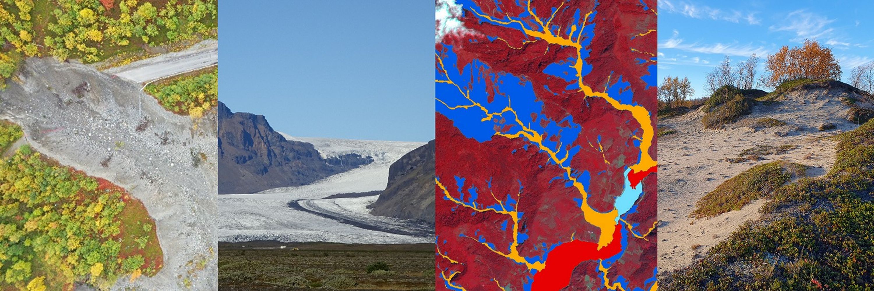
Remote Sensing and Geospatial Analysis for Natural Hazard and Risk Management. #NaturalHazards #EarthObservation #Geomorphology
https://plus.ac.at/risk-hazard-climate
Remote Sensing and Geospatial Analysis for Natural Hazard and Risk Management. #NaturalHazards #EarthObservation #Geomorphology
📢We are hiring!
🌍 We currently have two open positions in #geoinformatics and #remotesensing - from fundamental PhD research to applied data science work. Details & application:
1.) karriere.plus.ac.at/en/jobs/9dae...
2.) karriere.plus.ac.at/de/jobs/d3a9...
#geomorphology #earthobservation #InSAR
🌍 We currently have two open positions in #geoinformatics and #remotesensing - from fundamental PhD research to applied data science work. Details & application:
1.) karriere.plus.ac.at/en/jobs/9dae...
2.) karriere.plus.ac.at/de/jobs/d3a9...
#geomorphology #earthobservation #InSAR
November 3, 2025 at 7:43 AM
📢We are hiring!
🌍 We currently have two open positions in #geoinformatics and #remotesensing - from fundamental PhD research to applied data science work. Details & application:
1.) karriere.plus.ac.at/en/jobs/9dae...
2.) karriere.plus.ac.at/de/jobs/d3a9...
#geomorphology #earthobservation #InSAR
🌍 We currently have two open positions in #geoinformatics and #remotesensing - from fundamental PhD research to applied data science work. Details & application:
1.) karriere.plus.ac.at/en/jobs/9dae...
2.) karriere.plus.ac.at/de/jobs/d3a9...
#geomorphology #earthobservation #InSAR
What happens to mountain trails, hiking infrastructure and safety as glaciers retreat and the terrain becomes unstable? We recently had the exciting chance to share insights from our ReHIKE project in a great film by the Deutscher Alpenverein.
www.youtube.com/watch?v=0XS5...
www.youtube.com/watch?v=0XS5...

Was passiert, wenn der Berg bröckelt? Klimawandelfolgen in den Alpen, Teil 3
YouTube video by Deutscher Alpenverein (DAV)
www.youtube.com
October 11, 2025 at 7:42 AM
What happens to mountain trails, hiking infrastructure and safety as glaciers retreat and the terrain becomes unstable? We recently had the exciting chance to share insights from our ReHIKE project in a great film by the Deutscher Alpenverein.
www.youtube.com/watch?v=0XS5...
www.youtube.com/watch?v=0XS5...
Happy to share our new paper on #remotesensing of #peatlands 👇! Our research can inform understanding on how #Sentinel-1 #SAR data can support the mapping of this unique habitat and provide some insight into its relative condition. Many thanks to @jarrettinho.bsky.social for the great collaboration.
After 18 months of research with Dr Daniel Hölbling @zgis.bsky.social, our work on #Sentinel1 #sar to delineate #peatland has been published.
www.mdpi.com/2072-4292/17...
We have plenty more ideas to support #naturebasedsolutions. Check out our previous research www.mdpi.com/2335050
Get in touch.
www.mdpi.com/2072-4292/17...
We have plenty more ideas to support #naturebasedsolutions. Check out our previous research www.mdpi.com/2335050
Get in touch.

September 15, 2025 at 7:06 AM
Happy to share our new paper on #remotesensing of #peatlands 👇! Our research can inform understanding on how #Sentinel-1 #SAR data can support the mapping of this unique habitat and provide some insight into its relative condition. Many thanks to @jarrettinho.bsky.social for the great collaboration.
Great success for our group! We obtained funding for two highly reputable projects from @fwf-at.bsky.social: D. Hölbling leads the project "MorphEO - Big Earth observation for geomorphic mapping and monitoring", and Z. Dabiri leads "Urban flood impact on transport systems in Poland & Austria". 👏🥳

NEWS: Bei der letzten Kuratoriumssitzung des Wissenschaftsfonds FWF konnten gleich mehrere unserer Forschenden mit ihren innovativen Projektideen überzeugen. Mehr dazu: www.plus.ac.at/news/grosser...
#universitätsalzburg #fwf
#universitätsalzburg #fwf

Großer Erfolg für die Universität Salzburg: 4 Forscher*innen erhalten Förderungen - Universität Salzburg
Große Erfolge bei der FWF-Kuratoriumssitzung: Vier Projekte unserer Forschenden wurden bewilligt. Bei der letzten Kuratoriumssitzung des Wissenschaftsfonds FWF konnten gleich mehrere unserer Forschend...
www.plus.ac.at
August 10, 2025 at 5:22 PM
Great success for our group! We obtained funding for two highly reputable projects from @fwf-at.bsky.social: D. Hölbling leads the project "MorphEO - Big Earth observation for geomorphic mapping and monitoring", and Z. Dabiri leads "Urban flood impact on transport systems in Poland & Austria". 👏🥳
Meet our team at the #LPS25 poster sessions:
23.06, 17:45, R25 – CopPhil, Carla Arellano
24.06, 17:45, F05 – Rock Glaciers (InSAR), Elena Nafieva
26.06, 17:45, Q01 – Glacier Retreat, Zahra Dabiri
27.06, 13:00, M25 – DL Rock Glacier Mapping, Vanessa Streifeneder
See you there!
23.06, 17:45, R25 – CopPhil, Carla Arellano
24.06, 17:45, F05 – Rock Glaciers (InSAR), Elena Nafieva
26.06, 17:45, Q01 – Glacier Retreat, Zahra Dabiri
27.06, 13:00, M25 – DL Rock Glacier Mapping, Vanessa Streifeneder
See you there!
June 23, 2025 at 2:39 PM
Meet our team at the #LPS25 poster sessions:
23.06, 17:45, R25 – CopPhil, Carla Arellano
24.06, 17:45, F05 – Rock Glaciers (InSAR), Elena Nafieva
26.06, 17:45, Q01 – Glacier Retreat, Zahra Dabiri
27.06, 13:00, M25 – DL Rock Glacier Mapping, Vanessa Streifeneder
See you there!
23.06, 17:45, R25 – CopPhil, Carla Arellano
24.06, 17:45, F05 – Rock Glaciers (InSAR), Elena Nafieva
26.06, 17:45, Q01 – Glacier Retreat, Zahra Dabiri
27.06, 13:00, M25 – DL Rock Glacier Mapping, Vanessa Streifeneder
See you there!
Being out in the field is always exciting! Recently, we went to the Großarl Valley in Salzburg to interpret and validate #rockglacier mapping results we create in our project "ROGER". Our main goal was to better understand remote sensing-based deformation and movement rates derived from #InSAR.


June 10, 2025 at 3:13 PM
Being out in the field is always exciting! Recently, we went to the Großarl Valley in Salzburg to interpret and validate #rockglacier mapping results we create in our project "ROGER". Our main goal was to better understand remote sensing-based deformation and movement rates derived from #InSAR.
We can’t believe the #EGU25 is already half way through! We’re very grateful for all the discussions, new contacts, and meeting old friends! You can find us for the rest of the week at:
April 30, 2025 at 12:40 PM
We can’t believe the #EGU25 is already half way through! We’re very grateful for all the discussions, new contacts, and meeting old friends! You can find us for the rest of the week at:
#EGU25 is starting today and our group kickstarts showcasings of our projects with 3 different posters.
Hall X2 - 8:30 to 10:15 with results from the ROGER project:
X2.38 - How well do InSAR measurements align with rock glaciers in the Austrian Alps presented by Elena Nafieva
#InSAR #rockglacier
Hall X2 - 8:30 to 10:15 with results from the ROGER project:
X2.38 - How well do InSAR measurements align with rock glaciers in the Austrian Alps presented by Elena Nafieva
#InSAR #rockglacier
April 28, 2025 at 5:26 AM
#EGU25 is starting today and our group kickstarts showcasings of our projects with 3 different posters.
Hall X2 - 8:30 to 10:15 with results from the ROGER project:
X2.38 - How well do InSAR measurements align with rock glaciers in the Austrian Alps presented by Elena Nafieva
#InSAR #rockglacier
Hall X2 - 8:30 to 10:15 with results from the ROGER project:
X2.38 - How well do InSAR measurements align with rock glaciers in the Austrian Alps presented by Elena Nafieva
#InSAR #rockglacier
Reposted by Risk, Hazard & Climate Lab
Pleased to see my research with Daniel Hölbling used as part of the Environment Agency's Working With Nature report on the benefits of #naturalfloodmanagement.
#gis #sentinel1 #remotesensing can play a part in monitoring
www.gov.uk/government/n...
#gis #sentinel1 #remotesensing can play a part in monitoring
www.gov.uk/government/n...

March 30, 2025 at 6:15 PM
Pleased to see my research with Daniel Hölbling used as part of the Environment Agency's Working With Nature report on the benefits of #naturalfloodmanagement.
#gis #sentinel1 #remotesensing can play a part in monitoring
www.gov.uk/government/n...
#gis #sentinel1 #remotesensing can play a part in monitoring
www.gov.uk/government/n...
Happy to share our latest publication on the Influence of different #landslide inventories on shallow landslide susceptibility modeling in Brazil, authored by H. Dias, D. Hölbling and @carlosgrohmann.bsky.social
@zgis.bsky.social @mdpiopenaccess.bsky.social
doi.org/10.3390/geos...
@zgis.bsky.social @mdpiopenaccess.bsky.social
doi.org/10.3390/geos...

Examining the Influence of Different Inventories on Shallow Landslide Susceptibility Modeling: An Assessment Using Machine Learning and Statistical Approaches
Shallow landslides are one of the most common natural hazards in Brazil and worldwide. Susceptibility maps are powerful tools to analyze the spatial probability of shallow landslide occurrences. The o...
doi.org
February 24, 2025 at 1:55 PM
Happy to share our latest publication on the Influence of different #landslide inventories on shallow landslide susceptibility modeling in Brazil, authored by H. Dias, D. Hölbling and @carlosgrohmann.bsky.social
@zgis.bsky.social @mdpiopenaccess.bsky.social
doi.org/10.3390/geos...
@zgis.bsky.social @mdpiopenaccess.bsky.social
doi.org/10.3390/geos...
Recently, we had the kick-of meeting for our new project SpaDiFloVur (Spatial differentiation of the level of flood vulnerability of municipalities in Poland and Austria) at the University of Łódź. It was an excellent meeting with fruitful discussions, and we look forward to the upcoming work.

February 14, 2025 at 10:13 AM
Recently, we had the kick-of meeting for our new project SpaDiFloVur (Spatial differentiation of the level of flood vulnerability of municipalities in Poland and Austria) at the University of Łódź. It was an excellent meeting with fruitful discussions, and we look forward to the upcoming work.
🌍 Excited to convene a session at #IGC2026 in Christchurch, NZ! Join us for "Novel Geospatial & Remote Sensing Methods for Geomorphological Feature Mapping and Monitoring."
Submit your work by May 31st!
confer.co.nz/icg2026/tech... 🌏
Submit your work by May 31st!
confer.co.nz/icg2026/tech... 🌏

Technological advances in geomorphology - 2026 IAG International Conference on Geomorphology
Technological advances in geomorphology Geospatial Innovations in Geomorphological Research: Integrating Remote Sensing and Advanced Technologies Dr Ben
confer.co.nz
February 4, 2025 at 7:50 PM
🌍 Excited to convene a session at #IGC2026 in Christchurch, NZ! Join us for "Novel Geospatial & Remote Sensing Methods for Geomorphological Feature Mapping and Monitoring."
Submit your work by May 31st!
confer.co.nz/icg2026/tech... 🌏
Submit your work by May 31st!
confer.co.nz/icg2026/tech... 🌏