


@sausiuswx.bsky.social
Average weather enthusiast -
Main areas of interest: Tropical Cyclones and (European) severewx
Main areas of interest: Tropical Cyclones and (European) severewx
#OTDwx in 2006 Cyclone Bondo underwent a very impressive period of rapid intensification northeast of Madagascar. According to JTWC winds increased from 65 to 135 knots in 18 hours. During this time a pinhole eye (as small as ~8 nm) rapidly cleared and warmed to >15°C.
December 19, 2025 at 10:27 PM
#OTDwx in 2006 Cyclone Bondo underwent a very impressive period of rapid intensification northeast of Madagascar. According to JTWC winds increased from 65 to 135 knots in 18 hours. During this time a pinhole eye (as small as ~8 nm) rapidly cleared and warmed to >15°C.
Tropical Cyclone Bakung continues to exist but is only a shadow of what it was 2 days ago, when it most likely peaked at or near Major Cyclone (C3) strength. That peak was enabled by virtually zero shear. Since then however shear has increased to 15-25 knots and tiny Bakung can't cope with that.
December 15, 2025 at 6:17 PM
Tropical Cyclone Bakung continues to exist but is only a shadow of what it was 2 days ago, when it most likely peaked at or near Major Cyclone (C3) strength. That peak was enabled by virtually zero shear. Since then however shear has increased to 15-25 knots and tiny Bakung can't cope with that.
Tropical Cyclone 08P is the newest addition to the TC family, at least according to JTWC. FMS doesn't seem to believe it will become a TC by their standards but if it does, the name would be Urmil. Nothijng spectacular but may bring some Impacts to Fiji later in the week.
December 14, 2025 at 8:38 PM
Tropical Cyclone 08P is the newest addition to the TC family, at least according to JTWC. FMS doesn't seem to believe it will become a TC by their standards but if it does, the name would be Urmil. Nothijng spectacular but may bring some Impacts to Fiji later in the week.
Of course, while the programm I made with Gemini is primarily designed to get images of TCs, I can also use it to get images of other events. Like these images from MODIS of the Hanukkah Eve windstorm of 2006, which killed 18 people and caused 100s of Millions of dollars in damage. #OTDwx


December 14, 2025 at 8:17 PM
Of course, while the programm I made with Gemini is primarily designed to get images of TCs, I can also use it to get images of other events. Like these images from MODIS of the Hanukkah Eve windstorm of 2006, which killed 18 people and caused 100s of Millions of dollars in damage. #OTDwx
Tropical Cyclone Bakung as seen from the Modis Instrument aboard Aqua earlier today. This was when Bakung had reached another brief peak in intensity.


December 14, 2025 at 4:13 PM
Tropical Cyclone Bakung as seen from the Modis Instrument aboard Aqua earlier today. This was when Bakung had reached another brief peak in intensity.
Fresh of the press: Tropical Cyclone Bakung as seen by the MODIS instrument on NASA's Aqua Satellite about 2 and a half hours ago. This is band 31, which roughly corresponds to the 'dirty' IR Longwave product on GOES-R (not the 'Clean' IR) you usually see.


December 13, 2025 at 11:31 PM
Fresh of the press: Tropical Cyclone Bakung as seen by the MODIS instrument on NASA's Aqua Satellite about 2 and a half hours ago. This is band 31, which roughly corresponds to the 'dirty' IR Longwave product on GOES-R (not the 'Clean' IR) you usually see.
'Tropical Storm' Bakung as seen by the VIIRS instrument aboard NOAA-20 polar orbiting satellite in its closest equivelent to the familiar GOES IR channel (13) at 19:12 UTC (4 hours ago). If this actually only had winds of around 110 kph, I'd eat a broomstick.


December 13, 2025 at 11:29 PM
'Tropical Storm' Bakung as seen by the VIIRS instrument aboard NOAA-20 polar orbiting satellite in its closest equivelent to the familiar GOES IR channel (13) at 19:12 UTC (4 hours ago). If this actually only had winds of around 110 kph, I'd eat a broomstick.
Tropical Cyclone Bakung continues to swirl in the southeast Indian Ocean and continues to be criminally udnerestimated by agencies, even tho the displayed fix is old. Across the board, objective and subjective intensity fixes also continue to do very poorly in my opinion.
December 13, 2025 at 10:50 PM
Tropical Cyclone Bakung continues to swirl in the southeast Indian Ocean and continues to be criminally udnerestimated by agencies, even tho the displayed fix is old. Across the board, objective and subjective intensity fixes also continue to do very poorly in my opinion.
THIS STORM, Bakung, is currently a 60 kts tropical storm on the ATCF. Absolutely absurd. Ah yes, a more or less symmetrical CDO, with a distinct eye feature going into the low 50s below zero and cloud tops up to 85°C. Sure lets call it a tropical storm. BOM says C2 Aus Scale.

December 13, 2025 at 10:13 PM
THIS STORM, Bakung, is currently a 60 kts tropical storm on the ATCF. Absolutely absurd. Ah yes, a more or less symmetrical CDO, with a distinct eye feature going into the low 50s below zero and cloud tops up to 85°C. Sure lets call it a tropical storm. BOM says C2 Aus Scale.
Tiny Tropical Cyclone Bakung has undergone an impressive period of rapid intensification over the least several hours. Inside the tiny circulation now almost surely swirl winds far in excess of the category 1 threshold, likely C2+ already.
December 13, 2025 at 3:12 PM
Tiny Tropical Cyclone Bakung has undergone an impressive period of rapid intensification over the least several hours. Inside the tiny circulation now almost surely swirl winds far in excess of the category 1 threshold, likely C2+ already.
Going by UTC, it is still technically the anniversary of a day that will forever remain seared in my (and so many other peoples mind) memory. That of the 2021 'Mayfield Tornado'💔
In honor of that: Here is an image of that tornado outbreak made by the MODIS instrument.
In honor of that: Here is an image of that tornado outbreak made by the MODIS instrument.

December 11, 2025 at 11:26 PM
Going by UTC, it is still technically the anniversary of a day that will forever remain seared in my (and so many other peoples mind) memory. That of the 2021 'Mayfield Tornado'💔
In honor of that: Here is an image of that tornado outbreak made by the MODIS instrument.
In honor of that: Here is an image of that tornado outbreak made by the MODIS instrument.
On the afternoon of December 11th 1998 (local time), Cyclone Thelma, one of the most powerful Cyclones to be ever observed in these parts (135 kts at peak), made landfall along a deserted part of Australias Pilbara coast. Tragically, there was still one indirect death. #OTDwx
December 11, 2025 at 11:19 PM
On the afternoon of December 11th 1998 (local time), Cyclone Thelma, one of the most powerful Cyclones to be ever observed in these parts (135 kts at peak), made landfall along a deserted part of Australias Pilbara coast. Tragically, there was still one indirect death. #OTDwx
Tropics have been quite for quite a while but alas now here is Tropical Cyclone Seven in the southeast Indian Ocean. The system is expected to stay over open waters only and likely to stay weak, tho may become a C1 SSHWS. Also not sure if I have said "Welcome back Him-9" already.
December 11, 2025 at 11:18 PM
Tropics have been quite for quite a while but alas now here is Tropical Cyclone Seven in the southeast Indian Ocean. The system is expected to stay over open waters only and likely to stay weak, tho may become a C1 SSHWS. Also not sure if I have said "Welcome back Him-9" already.
Turns out I didn't EUMETSATs stupid coordinate file. So me and Gemini have now got Meteosat First generation to work. So here is Medicane Celano from January 16th 1995 as seen by the MIVIRI instrument of Meteosat 5 in visible and thermal infrared. True color isn't possible.


December 10, 2025 at 7:42 PM
Turns out I didn't EUMETSATs stupid coordinate file. So me and Gemini have now got Meteosat First generation to work. So here is Medicane Celano from January 16th 1995 as seen by the MIVIRI instrument of Meteosat 5 in visible and thermal infrared. True color isn't possible.
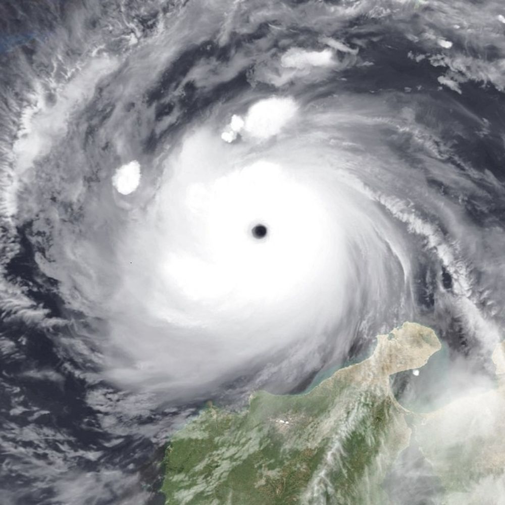
#StormBram as seen by the MODIS instrument aboard NASA's Aqua Satellite about 2 and half hours ago. At the time the main windfield was beginning to move across Ireland, SW England and Wales. Now dangerous winds are about to move into the Hebrides.


December 9, 2025 at 5:14 PM
#StormBram as seen by the MODIS instrument aboard NASA's Aqua Satellite about 2 and half hours ago. At the time the main windfield was beginning to move across Ireland, SW England and Wales. Now dangerous winds are about to move into the Hebrides.
I really really expected this to be a lot harder but thanks to Chiba University and their amazingly still operational FTP service and thanks to Gemini 3.0 Pro, I can present to you Cyclone Val raking the Samoan archipelego 24 days ago OTD as seen by JMA's GMS4 Satellite.

December 8, 2025 at 9:30 PM
I really really expected this to be a lot harder but thanks to Chiba University and their amazingly still operational FTP service and thanks to Gemini 3.0 Pro, I can present to you Cyclone Val raking the Samoan archipelego 24 days ago OTD as seen by JMA's GMS4 Satellite.
Well after a considerable gemini skill issue that I didn't question sufficiently, I finally got it to write me a scipt that can correctly access satellite data from EUMETSAT. As seen here by images of Subtropical Storm Karen from earlier this year.


December 8, 2025 at 8:10 PM
Well after a considerable gemini skill issue that I didn't question sufficiently, I finally got it to write me a scipt that can correctly access satellite data from EUMETSAT. As seen here by images of Subtropical Storm Karen from earlier this year.
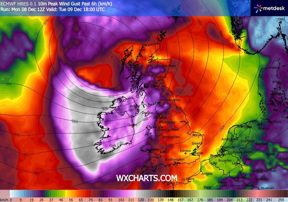
#StormBram has been named and will slam into the British Isles late tommorow. It is expected to bring storm-force gusts to large parts of Ireland & esp. Scotland. Most dangerous conditions are expected in the Hebrides, where gusts in excess of 160 km/h (100 mph) will be possible.


December 8, 2025 at 8:09 PM
#StormBram has been named and will slam into the British Isles late tommorow. It is expected to bring storm-force gusts to large parts of Ireland & esp. Scotland. Most dangerous conditions are expected in the Hebrides, where gusts in excess of 160 km/h (100 mph) will be possible.
I have really been cooking today👨🍳Now I have also implemented the ability to access historical Microwave images from the "TC-PRIMED" dataset. Here are a few samples, once again for the infamous Dorian, as it was punishing the island of Great Abaco.


December 7, 2025 at 1:42 AM
I have really been cooking today👨🍳Now I have also implemented the ability to access historical Microwave images from the "TC-PRIMED" dataset. Here are a few samples, once again for the infamous Dorian, as it was punishing the island of Great Abaco.
It was more difficult then I thought it would be but I can now also generate GOES-R and Himawari 8/9 'True Color' images. Major Hurricane Dorian from 2019 raking great Abaco and Super Typhoon Goni (RollyPH) from 2020 bearing down on Catanduanes attached for demonstration.


December 7, 2025 at 12:34 AM
It was more difficult then I thought it would be but I can now also generate GOES-R and Himawari 8/9 'True Color' images. Major Hurricane Dorian from 2019 raking great Abaco and Super Typhoon Goni (RollyPH) from 2020 bearing down on Catanduanes attached for demonstration.
I have now implemented the Visible (both single channel and 'true color' modes) for MODIS and VIIRS. To celebrate, here are the respective images of infamous Major Hurricane Melissa, as she approached her devestating landfall in Jamaica from MODIS and VIIRS.


December 6, 2025 at 5:26 PM
I have now implemented the Visible (both single channel and 'true color' modes) for MODIS and VIIRS. To celebrate, here are the respective images of infamous Major Hurricane Melissa, as she approached her devestating landfall in Jamaica from MODIS and VIIRS.
I have once again been cooking today. So far I have already successfully implemented the 700 nm Day/Night channel of VIIRS that essentially uses moonlight to turn night into day. Once again demonstrating with Typhoon Bopha on the way to its devestating landfall in Mindanao.

December 5, 2025 at 8:32 PM
I have once again been cooking today. So far I have already successfully implemented the 700 nm Day/Night channel of VIIRS that essentially uses moonlight to turn night into day. Once again demonstrating with Typhoon Bopha on the way to its devestating landfall in Mindanao.
Animation of the infamous 2022 Hunga Tonga–Hunga Haʻapai eruption to celebrate my ability to produce EIR loops for any coordinates.
Data courtesy of JMA and provided via AWS, Visualisation is my own with help from Gemini 3.0 Pro
Data courtesy of JMA and provided via AWS, Visualisation is my own with help from Gemini 3.0 Pro
December 3, 2025 at 10:49 PM
Animation of the infamous 2022 Hunga Tonga–Hunga Haʻapai eruption to celebrate my ability to produce EIR loops for any coordinates.
Data courtesy of JMA and provided via AWS, Visualisation is my own with help from Gemini 3.0 Pro
Data courtesy of JMA and provided via AWS, Visualisation is my own with help from Gemini 3.0 Pro
On this day in 2004 Typhoon Nanmadol made landfall in Luzon. Even tho the storm had weakened considerably from its peak intensity as a Super Typhoon (JTWC), it still packed a punch. 70 people perished and damages amounted to 39.3 Million dollars (67 mil in todays money). #OTDwx
December 2, 2025 at 11:09 PM
On this day in 2004 Typhoon Nanmadol made landfall in Luzon. Even tho the storm had weakened considerably from its peak intensity as a Super Typhoon (JTWC), it still packed a punch. 70 people perished and damages amounted to 39.3 Million dollars (67 mil in todays money). #OTDwx
OTD in 1991 Tropical Storm Zelda moved through the Marshall Islands and destroyed 60% of residences on Ebeye Island, leaving 6,000 people homless. Operations of Kwajalein Missile Range were also disrupted severely. Mainly just wanted to show off historical TC sat imagery ability


November 28, 2025 at 10:50 PM
OTD in 1991 Tropical Storm Zelda moved through the Marshall Islands and destroyed 60% of residences on Ebeye Island, leaving 6,000 people homless. Operations of Kwajalein Missile Range were also disrupted severely. Mainly just wanted to show off historical TC sat imagery ability