


Andrew Pritchard
@skydrama.bsky.social
Focused on Disruptive Weather | Award Winning Weather Risk Communicator | Observer of Severe Storms in the American Midwest ⛈️🌪️💨
SKYDRAMA.NET
SKYDRAMA.NET
Pinned
Andrew Pritchard
@skydrama.bsky.social
· Oct 18

Introducing myself here on 🦋
- Meteorologist born & raised in the American Midwest
- Focused on disruptive weather
- I've won some awards for weather risk communication
- I observed and document severe storms
- Rooting for 🏈🏀 Fighting Illini (local sports team), NIU Huskies (alma mater), ⚾ Cubs
- Meteorologist born & raised in the American Midwest
- Focused on disruptive weather
- I've won some awards for weather risk communication
- I observed and document severe storms
- Rooting for 🏈🏀 Fighting Illini (local sports team), NIU Huskies (alma mater), ⚾ Cubs
There's not much to latch onto with specificity, but it's nice to see an aggressive shift across the board on global models depicting the first breaths of spring and a potentially active storm track in mid-February: www.skydrama.net/post/here-we...

SKYDRAMA.NET • Here We Go? | First Breaths of Spring '26 Could be Near!
I've fallen into a nice routine over the last decade where I fly through my busy work-travel season speaking about weather at conferences and winter meetings which usually spans the 6-8 weeks immediat...
www.skydrama.net
February 4, 2026 at 4:59 PM
There's not much to latch onto with specificity, but it's nice to see an aggressive shift across the board on global models depicting the first breaths of spring and a potentially active storm track in mid-February: www.skydrama.net/post/here-we...
Reposted by Andrew Pritchard

December 2025 precipitation percentage of normal.

January 5, 2026 at 5:47 AM
December 2025 precipitation percentage of normal.
Reposted by Andrew Pritchard
December 2025 temperature departure from normal for the U.S. and Canada.

January 5, 2026 at 5:41 AM
December 2025 temperature departure from normal for the U.S. and Canada.
Freaking spectacular sunset over Champaign-Urbana this evening. Stepped outside with the dog and saw everything glowing orange, lucky enough to get the drone in the air in time to snap a few photos before the colors faded. Looks like there’s even a sun pillar tucked in there.

January 4, 2026 at 11:16 PM
Freaking spectacular sunset over Champaign-Urbana this evening. Stepped outside with the dog and saw everything glowing orange, lucky enough to get the drone in the air in time to snap a few photos before the colors faded. Looks like there’s even a sun pillar tucked in there.
Could be a couple of opportunities for strong to severe convection across the Midwest on Sunday, first as warm & humid air mass surges north Sunday AM and then again as cold front clears the area west to east on Sunday afternoon - Sunday night.

December 27, 2025 at 2:53 AM
Could be a couple of opportunities for strong to severe convection across the Midwest on Sunday, first as warm & humid air mass surges north Sunday AM and then again as cold front clears the area west to east on Sunday afternoon - Sunday night.
Push and pull of warm and muggy air from the south and colder air to the north over the next few days. Could culminate with a few strong storms across the Ohio and Lower/Mid Miss River Valleys later this weekend before we flip back to a colder pattern east of the Rockies.


December 26, 2025 at 3:36 PM
Push and pull of warm and muggy air from the south and colder air to the north over the next few days. Could culminate with a few strong storms across the Ohio and Lower/Mid Miss River Valleys later this weekend before we flip back to a colder pattern east of the Rockies.
First hints of moisture surging back northward as we head for a warm and muggy last week of December across the central and southern U.S.

December 22, 2025 at 4:51 PM
First hints of moisture surging back northward as we head for a warm and muggy last week of December across the central and southern U.S.
Revisiting the devastating April 26th, 2024 tornado in Nebraska and Iowa and talking through the experience of watching a massive tornado impact the community of Minden, Iowa: youtu.be/dWy1sqzoMWY?...

Real-Time Breakdown: The April 26, 2024 Minden, Iowa Tornado
YouTube video by Meteorologist Andrew Pritchard
youtu.be
December 8, 2025 at 12:40 AM
Revisiting the devastating April 26th, 2024 tornado in Nebraska and Iowa and talking through the experience of watching a massive tornado impact the community of Minden, Iowa: youtu.be/dWy1sqzoMWY?...
Open season for Arctic outbreaks from the Canadian Prairies into the Midwest/Great Lakes as this pattern just continues to reload with cold air through the middle of December.
December 3, 2025 at 2:37 PM
Open season for Arctic outbreaks from the Canadian Prairies into the Midwest/Great Lakes as this pattern just continues to reload with cold air through the middle of December.
Some scenes from yesterday's winter storm in central Illinois - fun at the Illinois vs Northwestern "Snow Bowl" and wandering around blowing snow in rural Champaign County earlier in the day:
youtu.be/PHHRxX6WUuk
youtu.be/PHHRxX6WUuk

I was at the Illini "Snow Bowl" Football Game! | Winter Storm in the Midwest
YouTube video by Meteorologist Andrew Pritchard
youtu.be
November 30, 2025 at 5:22 PM
Some scenes from yesterday's winter storm in central Illinois - fun at the Illinois vs Northwestern "Snow Bowl" and wandering around blowing snow in rural Champaign County earlier in the day:
youtu.be/PHHRxX6WUuk
youtu.be/PHHRxX6WUuk
Here's a link to the premiere of my annual year-end storm chasing flick 'SKYDRAMA 2025'.
It's a long watch! Avoid the cold wind and watch it all at once, or enjoy it with leftovers through the holiday weekend. Cheers!
www.youtube.com/watch?v=dGLH...
It's a long watch! Avoid the cold wind and watch it all at once, or enjoy it with leftovers through the holiday weekend. Cheers!
www.youtube.com/watch?v=dGLH...

SKYDRAMA 2025 | The 2025 Storm Observation Season
YouTube video by Meteorologist Andrew Pritchard
www.youtube.com
November 26, 2025 at 7:01 PM
Here's a link to the premiere of my annual year-end storm chasing flick 'SKYDRAMA 2025'.
It's a long watch! Avoid the cold wind and watch it all at once, or enjoy it with leftovers through the holiday weekend. Cheers!
www.youtube.com/watch?v=dGLH...
It's a long watch! Avoid the cold wind and watch it all at once, or enjoy it with leftovers through the holiday weekend. Cheers!
www.youtube.com/watch?v=dGLH...
My big year-end storm chasing flick premieres on at 7:15 PM CT this evening! I'll share a YouTube link when it's available but wanted to put it on your radar if you're not traveling and want to join me for the live premier!

November 26, 2025 at 4:59 PM
My big year-end storm chasing flick premieres on at 7:15 PM CT this evening! I'll share a YouTube link when it's available but wanted to put it on your radar if you're not traveling and want to join me for the live premier!
48 hours until the release!
SKYDRAMA 2025 has a daunting 3 hour runtime highlighting 15 storm observation days with supercells and tornadoes across 8 states and 5 months. I can’t wait to share it!
SKYDRAMA 2025 has a daunting 3 hour runtime highlighting 15 storm observation days with supercells and tornadoes across 8 states and 5 months. I can’t wait to share it!
It's the wonder of nature, baby! SKYDRAMA 2025 is coming.
My annual year-end storm chasing flick promises to be one of my longest winded ever, packed with supercells and tornadoes from the Great Plains to the Midwest.
Wednesday night before Thanksgiving release, Nov 26!
My annual year-end storm chasing flick promises to be one of my longest winded ever, packed with supercells and tornadoes from the Great Plains to the Midwest.
Wednesday night before Thanksgiving release, Nov 26!

November 25, 2025 at 12:31 AM
48 hours until the release!
SKYDRAMA 2025 has a daunting 3 hour runtime highlighting 15 storm observation days with supercells and tornadoes across 8 states and 5 months. I can’t wait to share it!
SKYDRAMA 2025 has a daunting 3 hour runtime highlighting 15 storm observation days with supercells and tornadoes across 8 states and 5 months. I can’t wait to share it!
I wouldn't discount a strong tornado or two across east Texas or western Louisiana between 5 PM - 10 PM this evening.
If storms don't get too messy too early, late evening shear profiles are pretty impressive and could support sustained supercells and damaging tornado risk.
If storms don't get too messy too early, late evening shear profiles are pretty impressive and could support sustained supercells and damaging tornado risk.
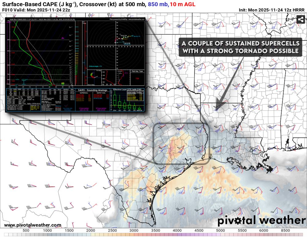
November 24, 2025 at 3:44 PM
I wouldn't discount a strong tornado or two across east Texas or western Louisiana between 5 PM - 10 PM this evening.
If storms don't get too messy too early, late evening shear profiles are pretty impressive and could support sustained supercells and damaging tornado risk.
If storms don't get too messy too early, late evening shear profiles are pretty impressive and could support sustained supercells and damaging tornado risk.
A little under .30” in my Urbana, IL backyard from overnight rain.
We could see a little more through mid-day, but this is probably about it until Thu/Fri. We’ll take it.
We could see a little more through mid-day, but this is probably about it until Thu/Fri. We’ll take it.

November 18, 2025 at 3:27 PM
A little under .30” in my Urbana, IL backyard from overnight rain.
We could see a little more through mid-day, but this is probably about it until Thu/Fri. We’ll take it.
We could see a little more through mid-day, but this is probably about it until Thu/Fri. We’ll take it.
November 17th, 2013 was a top 3 scary weather day locally. My hometown (Urbana) was called out in the day one severe weather outlook from the SPC, and I found myself pacing the kitchen with anxiety that morning.
Damaging tornadoes split Champaign-Urbana north and south of town.
Damaging tornadoes split Champaign-Urbana north and south of town.


November 17, 2025 at 4:40 PM
November 17th, 2013 was a top 3 scary weather day locally. My hometown (Urbana) was called out in the day one severe weather outlook from the SPC, and I found myself pacing the kitchen with anxiety that morning.
Damaging tornadoes split Champaign-Urbana north and south of town.
Damaging tornadoes split Champaign-Urbana north and south of town.
Thanks to a persistent continental ridge across western/central North America there's a lot of warm & dry on the map as we look at November temperatures and precipitation so far.
Top 10 warmest November so far west of the Rockies, much of the Lower 48 off to a very dry start.
Top 10 warmest November so far west of the Rockies, much of the Lower 48 off to a very dry start.


November 17, 2025 at 3:24 PM
Thanks to a persistent continental ridge across western/central North America there's a lot of warm & dry on the map as we look at November temperatures and precipitation so far.
Top 10 warmest November so far west of the Rockies, much of the Lower 48 off to a very dry start.
Top 10 warmest November so far west of the Rockies, much of the Lower 48 off to a very dry start.
We haven't seen a trough west / ridge east pattern establish itself across the U.S. since the early spring months in 2025!
Likely looking at a run of high-impact storm systems and some desperately needed heavy rainfall from the Southern Plains to the Ohio Valley next week.
Likely looking at a run of high-impact storm systems and some desperately needed heavy rainfall from the Southern Plains to the Ohio Valley next week.


November 13, 2025 at 5:17 PM
We haven't seen a trough west / ridge east pattern establish itself across the U.S. since the early spring months in 2025!
Likely looking at a run of high-impact storm systems and some desperately needed heavy rainfall from the Southern Plains to the Ohio Valley next week.
Likely looking at a run of high-impact storm systems and some desperately needed heavy rainfall from the Southern Plains to the Ohio Valley next week.
I'm starting to gain confidence in a potentially stormy finish to November which could feature more than one opportunity for organized severe thunderstorms and heavy rain from the Southern Plains to the Ohio Valley in the last ten days of November:
www.skydrama.net/post/stormy-...
www.skydrama.net/post/stormy-...

SKYDRAMA.NET • Stormy Finish to November? | Series of Severe Storms, Heavy Rainfall Possible Nov 18-25
Continental ridging and weak jet stream flow has kept the weather pattern relatively quiet east of the Rockies over the last two months allowing drought to quickly expand from the Southern Plains into...
www.skydrama.net
November 13, 2025 at 5:03 PM
I'm starting to gain confidence in a potentially stormy finish to November which could feature more than one opportunity for organized severe thunderstorms and heavy rain from the Southern Plains to the Ohio Valley in the last ten days of November:
www.skydrama.net/post/stormy-...
www.skydrama.net/post/stormy-...
Lots of chatter about a potentially cold & wintry December, but on the way there we may be looking at a pattern supporting of one or more organized severe weather events from the Southern Plains into the Ohio Valley and Gulf Coast focused ~ Nov 18-24, shifting cold after?


November 12, 2025 at 9:49 PM
Lots of chatter about a potentially cold & wintry December, but on the way there we may be looking at a pattern supporting of one or more organized severe weather events from the Southern Plains into the Ohio Valley and Gulf Coast focused ~ Nov 18-24, shifting cold after?
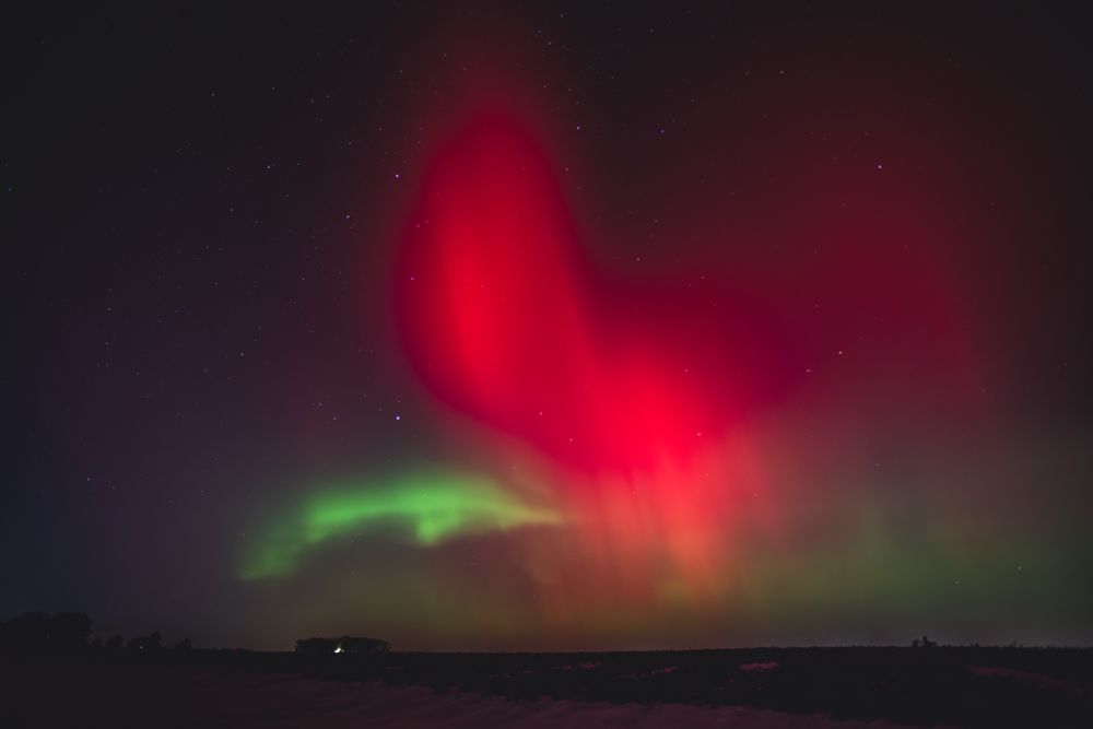
What a fun night! I always know there are top tier photographers out there capturing the “photos of the night” so I ventured out to my usual spot, a quiet little tire track road north of town and enjoyed the show with some peace and quiet. Champaign County, Illinois between 8-10 PM CT.


November 12, 2025 at 12:31 PM
What a fun night! I always know there are top tier photographers out there capturing the “photos of the night” so I ventured out to my usual spot, a quiet little tire track road north of town and enjoyed the show with some peace and quiet. Champaign County, Illinois between 8-10 PM CT.
Snow depth on Tuesday morning follow the first big lake-effect snow event of the season across the Great Lakes. A lot of this will be melting over the next few days as warmer temperatures build back into the region.

November 11, 2025 at 4:01 PM
Snow depth on Tuesday morning follow the first big lake-effect snow event of the season across the Great Lakes. A lot of this will be melting over the next few days as warmer temperatures build back into the region.
It's the wonder of nature, baby! SKYDRAMA 2025 is coming.
My annual year-end storm chasing flick promises to be one of my longest winded ever, packed with supercells and tornadoes from the Great Plains to the Midwest.
Wednesday night before Thanksgiving release, Nov 26!
My annual year-end storm chasing flick promises to be one of my longest winded ever, packed with supercells and tornadoes from the Great Plains to the Midwest.
Wednesday night before Thanksgiving release, Nov 26!
November 11, 2025 at 2:28 PM
It's the wonder of nature, baby! SKYDRAMA 2025 is coming.
My annual year-end storm chasing flick promises to be one of my longest winded ever, packed with supercells and tornadoes from the Great Plains to the Midwest.
Wednesday night before Thanksgiving release, Nov 26!
My annual year-end storm chasing flick promises to be one of my longest winded ever, packed with supercells and tornadoes from the Great Plains to the Midwest.
Wednesday night before Thanksgiving release, Nov 26!
Here's another aerial shot from Urbana, IL looking southeast toward Sidney in the distance. Looks like visibility is improving across Champaign County this morning, but you can still tell it's blowing around in rural areas which may keep rural roadways slick through mid-day.

November 10, 2025 at 3:04 PM
Here's another aerial shot from Urbana, IL looking southeast toward Sidney in the distance. Looks like visibility is improving across Champaign County this morning, but you can still tell it's blowing around in rural areas which may keep rural roadways slick through mid-day.
Champaign-Urbana and the University of Illinois campus look beautiful this morning with a fresh coating of snow and our brilliant autumn color palette. Looks great from above, but roads are problematic across Champaign County so stay home and enjoy from the window if you're able.

November 10, 2025 at 3:02 PM
Champaign-Urbana and the University of Illinois campus look beautiful this morning with a fresh coating of snow and our brilliant autumn color palette. Looks great from above, but roads are problematic across Champaign County so stay home and enjoy from the window if you're able.