


THE Nadinesa
@thenadinesa.bsky.social
Geospatial Executive Director and Visionary | Ex- CEO Open Geospatial Consortium (OGC) | MIT Alum | All Geospatial - Innovation - Partnership - Impact | Jazzercise Franchisee | Single mom | 🇱🇧
For those curious about moving from desktop GIS to the cloud, here's a comprehensive resource from @forrest.nyc
forrest.nyc/from-desktop...
forrest.nyc/from-desktop...
From Desktop GIS to Cloud: A Beginner’s Roadmap to Modern GIS Tool - Matt Forrest
Modern GIS is changing fast. If you’ve been working with QGIS, ArcGIS, or any other desktop GIS tool, you’ve probably hit some limitations—datasets getting too big, processing times slowing down, and ...
forrest.nyc
March 8, 2025 at 4:58 PM
For those curious about moving from desktop GIS to the cloud, here's a comprehensive resource from @forrest.nyc
forrest.nyc/from-desktop...
forrest.nyc/from-desktop...
"game changer" dataset - first computer-modeled, historical water level and wave dataset for the Atlantic, Caribbean and Gulf coasts. Data from 1979 to 2022! Help improve flood-mitigation tools and flood risk assessment.
www.guiceoffshore.com/new-noaa-dat...
www.guiceoffshore.com/new-noaa-dat...

NOAA Coastal Ocean Reanalysis (CORA) | Offshore Maritime Vessel
Coastal Ocean Reanalysis (CORA)'s denser data resolution between tide gauges closes gaps in data coverage along the coast.
www.guiceoffshore.com
March 5, 2025 at 7:57 PM
"game changer" dataset - first computer-modeled, historical water level and wave dataset for the Atlantic, Caribbean and Gulf coasts. Data from 1979 to 2022! Help improve flood-mitigation tools and flood risk assessment.
www.guiceoffshore.com/new-noaa-dat...
www.guiceoffshore.com/new-noaa-dat...
I just came across this Geographers without Borders podcast focused on empowering women's voices in geosciences - supported by @womeningis.bsky.social
podcasts.apple.com/us/podcast/g...
podcasts.apple.com/us/podcast/g...

Geographers without Borders
Science Podcast · 2 Seasons · Updated Monthly
podcasts.apple.com
March 4, 2025 at 10:07 PM
I just came across this Geographers without Borders podcast focused on empowering women's voices in geosciences - supported by @womeningis.bsky.social
podcasts.apple.com/us/podcast/g...
podcasts.apple.com/us/podcast/g...
Reposted by THE Nadinesa

Is anyone up to test my geoparquet downloader qgis plugin? We want to change the directory in the latest release, which means migrating users from the old plugin to the 'new' one. If you could try out github.com/user-attachm... and let me know how it works I'd appreciate it.
github.com
March 2, 2025 at 10:52 PM
Is anyone up to test my geoparquet downloader qgis plugin? We want to change the directory in the latest release, which means migrating users from the old plugin to the 'new' one. If you could try out github.com/user-attachm... and let me know how it works I'd appreciate it.
Reposted by THE Nadinesa

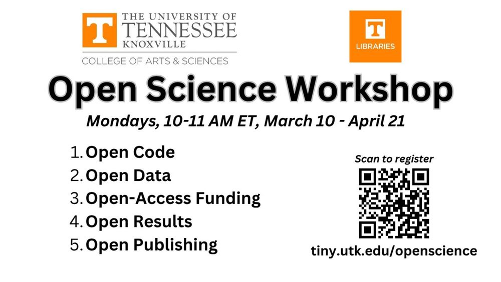
🌟 I am excited to invite you to participate in the upcoming Open Science Workshop and Symposium, sponsored by the University of Tennessee College of Arts & Sciences. This series aims to enhance awareness and engagement in open science practices across our community.
March 3, 2025 at 6:40 PM
🌟 I am excited to invite you to participate in the upcoming Open Science Workshop and Symposium, sponsored by the University of Tennessee College of Arts & Sciences. This series aims to enhance awareness and engagement in open science practices across our community.
Reposted by THE Nadinesa
🚀 #GeoAI Tutorial 2: Downloading NAIP Imagery & Building Footprint Data for Deep Learning 🌍✨
🔗 Watch the tutorial: youtu.be/5qfZe_fITcM
🛠️ Explore the GitHub: github.com/opengeos/geoai
📚 Dive into the Docs: geoai.gishub.org
🎥 YouTube Playlist: bit.ly/GeoAI-Tutori...
#geospatial #ai #python
🔗 Watch the tutorial: youtu.be/5qfZe_fITcM
🛠️ Explore the GitHub: github.com/opengeos/geoai
📚 Dive into the Docs: geoai.gishub.org
🎥 YouTube Playlist: bit.ly/GeoAI-Tutori...
#geospatial #ai #python

March 3, 2025 at 5:12 PM
🚀 #GeoAI Tutorial 2: Downloading NAIP Imagery & Building Footprint Data for Deep Learning 🌍✨
🔗 Watch the tutorial: youtu.be/5qfZe_fITcM
🛠️ Explore the GitHub: github.com/opengeos/geoai
📚 Dive into the Docs: geoai.gishub.org
🎥 YouTube Playlist: bit.ly/GeoAI-Tutori...
#geospatial #ai #python
🔗 Watch the tutorial: youtu.be/5qfZe_fITcM
🛠️ Explore the GitHub: github.com/opengeos/geoai
📚 Dive into the Docs: geoai.gishub.org
🎥 YouTube Playlist: bit.ly/GeoAI-Tutori...
#geospatial #ai #python
AI, modeling, and geospatial in action for disaster (floods in this case) preparedness and response.
blog.google/technology/a...
blog.google/technology/a...

Advanced Flood Hub features for aid organizations and governments
An overview of our latest expert tools in Flood Hub and our partnerships to support vulnerable communities.
blog.google
March 2, 2025 at 6:38 PM
AI, modeling, and geospatial in action for disaster (floods in this case) preparedness and response.
blog.google/technology/a...
blog.google/technology/a...
Nice opportunity for an early career professional www.bezosfamilyfoundation.org/careers

Careers | Bezos Family Foundation
Join the Bezos Family Foundation as we fund research and programs that unlock learning and the potential of young people.
www.bezosfamilyfoundation.org
March 2, 2025 at 6:34 PM
Nice opportunity for an early career professional www.bezosfamilyfoundation.org/careers
FYI New Edition of GIS Cartography: A Guide to Effective Map Design is out
www.taylorfrancis.com/books/mono/1...
www.taylorfrancis.com/books/mono/1...

GIS Cartography | A Guide to Effective Map Design | Gretchen N. Peters
The new edition of this well-established introductory cartography textbook is updated to respond to the demand for critical engagement with new technologies,
www.taylorfrancis.com
March 2, 2025 at 3:50 PM
FYI New Edition of GIS Cartography: A Guide to Effective Map Design is out
www.taylorfrancis.com/books/mono/1...
www.taylorfrancis.com/books/mono/1...
This is one of the most useful threads with starter packs for all things geospatial. Highly recommend :) Thanks @satellitesci.bsky.social

There's now so many awesome #geospatial people here it's hard to keep track! 🤩
Here's a thread of some of my favourite starter packs so far - let me know what I've missed!
🛰️ Earth Observation & remote sensing: go.bsky.app/4PMRhNL
🌏 GIS: go.bsky.app/TJ7qQF6 @milos-makes-maps.bsky.social
(1/n)
Here's a thread of some of my favourite starter packs so far - let me know what I've missed!
🛰️ Earth Observation & remote sensing: go.bsky.app/4PMRhNL
🌏 GIS: go.bsky.app/TJ7qQF6 @milos-makes-maps.bsky.social
(1/n)
February 28, 2025 at 5:11 AM
This is one of the most useful threads with starter packs for all things geospatial. Highly recommend :) Thanks @satellitesci.bsky.social
Heads up to researchers looking for high-resolution imagery: Satellogic is making their EarthView dataset openly available on AWS
satellogic.com/news/press-r...
satellogic.com/news/press-r...

Satellogic EarthView Dataset Now Openly Accessible via Registry of Open Data on AWS - Satellogic
Having the Satellogic EarthView dataset available on AWS unlocks scalable access to a vast collection of high-resolution satellite imagery. The AWS Open Data Sponsorship Program covers the cost of sto...
satellogic.com
February 28, 2025 at 4:59 AM
Heads up to researchers looking for high-resolution imagery: Satellogic is making their EarthView dataset openly available on AWS
satellogic.com/news/press-r...
satellogic.com/news/press-r...
More job resources in the geospatial industry compiled by some amazing people in this community.
www.linkedin.com/feed/update/...
www.linkedin.com/feed/update/...
February 28, 2025 at 4:41 AM
More job resources in the geospatial industry compiled by some amazing people in this community.
www.linkedin.com/feed/update/...
www.linkedin.com/feed/update/...
Fantastic collaboration opportunity with some of the best in geospatial and AI. Check out the full post.
I'm incredibly pumped that we'll be launching 'phase 2' of the TGE initiative that lead to Fields of The World (fieldsofthe.world) and fiboa (github.com/fiboa). And I'd like to invite you to join us!
See tgengine.org/tge-innovati... for the full post, and read on for some more information.
See tgengine.org/tge-innovati... for the full post, and read on for some more information.
February 26, 2025 at 3:03 PM
Fantastic collaboration opportunity with some of the best in geospatial and AI. Check out the full post.
Many people are currently looking for a job - this geospatial hub and the @geospatialwomen.bsky.social career updates are all great places to stay on top of geospatial opportunities.
February 26, 2025 at 3:43 AM
Many people are currently looking for a job - this geospatial hub and the @geospatialwomen.bsky.social career updates are all great places to stay on top of geospatial opportunities.
Reposted by THE Nadinesa
Just published a post on new features in the GeoParquet Downloader QGIS Plug-in I've been working on, see cholmes.medium.com/new-features...
The most exciting thing to me is that a majority of the new enhancements have come from outside contributors.
The most exciting thing to me is that a majority of the new enhancements have come from outside contributors.
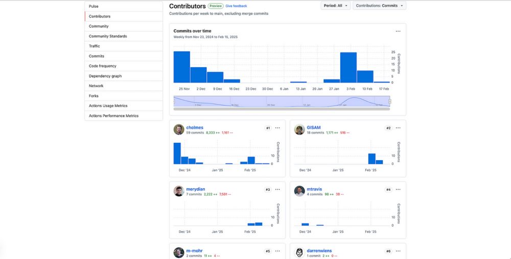
New Features of GeoParquet Downloader QGIS Plugin
Many new improvements have landed recently, from a variety of contributors, turning this plug-in to a true open source project
cholmes.medium.com
February 20, 2025 at 11:58 PM
Just published a post on new features in the GeoParquet Downloader QGIS Plug-in I've been working on, see cholmes.medium.com/new-features...
The most exciting thing to me is that a majority of the new enhancements have come from outside contributors.
The most exciting thing to me is that a majority of the new enhancements have come from outside contributors.
Saw this posted by @gcamara.bsky.social open-source R package of big Earth observation data analysis using satellite image time series
e-sensing.github.io/sitsbook/
e-sensing.github.io/sitsbook/
Preface | sits: Satellite Image Time Series Analysis on Earth Observation Data Cubes
This book presents sits, an open-source R package for satellite image time series analysis. The package supports the application of machine learning techniques for classifying image time series obtain...
e-sensing.github.io
February 16, 2025 at 9:54 PM
Saw this posted by @gcamara.bsky.social open-source R package of big Earth observation data analysis using satellite image time series
e-sensing.github.io/sitsbook/
e-sensing.github.io/sitsbook/
FYI - New Github from NASA EarthData
www.earthdata.nasa.gov/news/new-jup...
www.earthdata.nasa.gov/news/new-jup...

New Jupyter Notebook GitHub Repository Offers Tips and Scripts for Using NASA’s Atmospheric Data | NASA Earthdata
NASA’s Atmospheric Science Data Center (ASDC) GitHub hosts tutorials, code, and guides to help Earth science data users address air quality and other environmental challenges.
www.earthdata.nasa.gov
February 16, 2025 at 9:16 PM
FYI - New Github from NASA EarthData
www.earthdata.nasa.gov/news/new-jup...
www.earthdata.nasa.gov/news/new-jup...
New event in our community - Cesium's first devcon
hubs.li/Q035RKjr0
hubs.li/Q035RKjr0

2025 Cesium Developer Conference Call for Presentations
2025 Cesium Developer Conference call for presentations
hubs.li
February 16, 2025 at 5:59 PM
New event in our community - Cesium's first devcon
hubs.li/Q035RKjr0
hubs.li/Q035RKjr0
Reposted by THE Nadinesa

Excited to announce my hands-on & in person workshop: "Introduction to 3D maps and data visualisation with Blender". You will learn how to create memorable 3D visualisations that stand out. #dataviz
Register here: lu.ma/gtg2elht
Register here: lu.ma/gtg2elht

London Data Visualisation February - Blender Workshop · Luma
If you feel inspired by the visual journalism of the New York Times, winners of the Information is Beautiful awards or the wonderfully crafted graphics of…
lu.ma
February 11, 2025 at 5:07 PM
Excited to announce my hands-on & in person workshop: "Introduction to 3D maps and data visualisation with Blender". You will learn how to create memorable 3D visualisations that stand out. #dataviz
Register here: lu.ma/gtg2elht
Register here: lu.ma/gtg2elht
Reposted by THE Nadinesa
You, yes you, can help the Cloud Native Geospatial Movement!
Have you benefitted from Cloud-Optimized GeoTIFF’s? SpatioTemporal Asset Catalogs? Zarr, COPC or GeoParquet? And the ecosystem around them?
Learn how to give back in my post: cholmes.medium.com/you-yes-you-...
Have you benefitted from Cloud-Optimized GeoTIFF’s? SpatioTemporal Asset Catalogs? Zarr, COPC or GeoParquet? And the ecosystem around them?
Learn how to give back in my post: cholmes.medium.com/you-yes-you-...
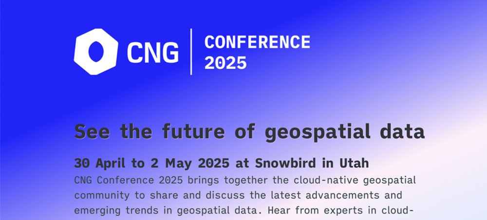
You, yes you, can help the Cloud Native Geospatial Movement!
Have you benefitted from COG’s, STAC, Zarr, COPC or GeoParquet? Join us in Utah for the first CNG Conference and help just by attending.
cholmes.medium.com
February 10, 2025 at 10:00 PM
You, yes you, can help the Cloud Native Geospatial Movement!
Have you benefitted from Cloud-Optimized GeoTIFF’s? SpatioTemporal Asset Catalogs? Zarr, COPC or GeoParquet? And the ecosystem around them?
Learn how to give back in my post: cholmes.medium.com/you-yes-you-...
Have you benefitted from Cloud-Optimized GeoTIFF’s? SpatioTemporal Asset Catalogs? Zarr, COPC or GeoParquet? And the ecosystem around them?
Learn how to give back in my post: cholmes.medium.com/you-yes-you-...
20 years of Google Maps. Wow! blog.google/products/map...

20 things you didn’t know you could do with Google Maps
Google Maps celebrates 20 years with 20 favorite features
blog.google
February 11, 2025 at 12:24 AM
20 years of Google Maps. Wow! blog.google/products/map...
Anyone been to this conference before? Wireless and Geographical Information Systems - next one in September in Mexico City
sites.google.com/view/w2gis-2...
sites.google.com/view/w2gis-2...

W2GIS 2025
W2GIS 2025
Recent advances in wireless Internet and location-based services have generated increasing interest in the diffusion and processing of large volumes of geospatial data. Then, new challenges...
sites.google.com
February 9, 2025 at 8:59 PM
Anyone been to this conference before? Wireless and Geographical Information Systems - next one in September in Mexico City
sites.google.com/view/w2gis-2...
sites.google.com/view/w2gis-2...
Reposted by THE Nadinesa

After making a massive $7.19 in 4 months (less than the $10 payout threshold), I've decided to start ungating my Medium-hosted tutorials (it's not really in the knowledge-sharing spirit anyway!) and migrate them to my website, starting with... www.helenmakesmaps.com/post/how-to-... 🎆🗺️
How to make a firefly map with QGIS
Follow this quick and easy guide to create stunning firefly maps with QGIS! 🌟
www.helenmakesmaps.com
January 17, 2025 at 11:10 AM
After making a massive $7.19 in 4 months (less than the $10 payout threshold), I've decided to start ungating my Medium-hosted tutorials (it's not really in the knowledge-sharing spirit anyway!) and migrate them to my website, starting with... www.helenmakesmaps.com/post/how-to-... 🎆🗺️
Not sure if Robert Cheetham is on here yet, but I just read his newsletter about the Japan EO market and loved it! Check out the list of Geo/EO events in that area of the world
www.japanearthobserver.com/japan-earth-...
www.japanearthobserver.com/japan-earth-...

JEO 1 - 2024 Year in Review
Welcome to the first edition of Japan Earth Observer (JEO)
www.japanearthobserver.com
February 9, 2025 at 8:44 PM
Not sure if Robert Cheetham is on here yet, but I just read his newsletter about the Japan EO market and loved it! Check out the list of Geo/EO events in that area of the world
www.japanearthobserver.com/japan-earth-...
www.japanearthobserver.com/japan-earth-...
Interesting - ChatGPT in education
openai.com/index/openai...
openai.com/index/openai...

OpenAI and the CSU system bring AI to 500,000 students & faculty
The largest deployment of ChatGPT to date will expand the use of AI in education and help the United States build an AI-ready workforce.
openai.com
February 9, 2025 at 8:39 PM
Interesting - ChatGPT in education
openai.com/index/openai...
openai.com/index/openai...