


@transkibton.bsky.social
#30daymapchallenge Day 26: Transport. A map of West African Ports - in terms of the region this may appear to be an eclectic selection - but it is where my day job happens to be.

November 26, 2025 at 8:10 AM
#30daymapchallenge Day 26: Transport. A map of West African Ports - in terms of the region this may appear to be an eclectic selection - but it is where my day job happens to be.
#30daymapchallenge Day 25: Hexagons. Revisiting my Day 1 dataset - the OS trig point database. Point density again shows a concentration in urban areas.

November 25, 2025 at 7:01 AM
#30daymapchallenge Day 25: Hexagons. Revisiting my Day 1 dataset - the OS trig point database. Point density again shows a concentration in urban areas.
#30daymapchallenge Day 24: Places and their names. 'Bostals'. This map shows the steep roads and paths known as Bostals in Sussex Dialect. Sussex Dialect is also notable for having >30 words for mud - some of which remain in use in modern English. "We wunt be druv!"

November 24, 2025 at 7:48 AM
#30daymapchallenge Day 24: Places and their names. 'Bostals'. This map shows the steep roads and paths known as Bostals in Sussex Dialect. Sussex Dialect is also notable for having >30 words for mud - some of which remain in use in modern English. "We wunt be druv!"
#30daymapchallenge Day 23: Process. I used QGIS to make a map of the main things to think of when I make a basic map in QGIS. Did I miss anything?

November 23, 2025 at 9:53 AM
#30daymapchallenge Day 23: Process. I used QGIS to make a map of the main things to think of when I make a basic map in QGIS. Did I miss anything?
#30daymapchallenge Day 22: Natural Earth. The World's Top 10 Reservoirs by Surface Area. All features from Natural Earth. QQIS Multi Maps plugin was useful to compile. The conclusion: Lake Victoria is very large!

November 22, 2025 at 9:39 AM
#30daymapchallenge Day 22: Natural Earth. The World's Top 10 Reservoirs by Surface Area. All features from Natural Earth. QQIS Multi Maps plugin was useful to compile. The conclusion: Lake Victoria is very large!
#30daymapchallenge Day 21: Icons. I rifled through the OSM legend to pick an icon. Brighton Pubs. The City is famous for having a high density of them. Given current cost of living challenges, many are struggling. Use them while you can.

November 21, 2025 at 8:27 AM
#30daymapchallenge Day 21: Icons. I rifled through the OSM legend to pick an icon. Brighton Pubs. The City is famous for having a high density of them. Given current cost of living challenges, many are struggling. Use them while you can.
#30daymapchallenge Day 20: Water. I made this global map to use as a lock screen image for my laptop. I think the black continents really emphasise the bathymetry and I am happy to see it every day. Bathymetry data is Natural Earth Ocean Bottom 50m.

November 20, 2025 at 8:25 AM
#30daymapchallenge Day 20: Water. I made this global map to use as a lock screen image for my laptop. I think the black continents really emphasise the bathymetry and I am happy to see it every day. Bathymetry data is Natural Earth Ocean Bottom 50m.
#30daymapchallenge Day 19: Projections. Countries of the Prime Meridian. I live 10k West of the last marker before Meridian leaves the South coast of the UK. This is the view I think of looking from the clifftop over the sea. It is also a map where the North arrow adds value...

November 19, 2025 at 8:13 AM
#30daymapchallenge Day 19: Projections. Countries of the Prime Meridian. I live 10k West of the last marker before Meridian leaves the South coast of the UK. This is the view I think of looking from the clifftop over the sea. It is also a map where the North arrow adds value...
#30daymapchallenge Day 18: Out of This World. A simple map of the Moon showing craters >20km. Made using the excellent interactive tool at quickmap.lroc.im-ldi.com.

November 18, 2025 at 8:19 AM
#30daymapchallenge Day 18: Out of This World. A simple map of the Moon showing craters >20km. Made using the excellent interactive tool at quickmap.lroc.im-ldi.com.
#30daymapchallenge Day 17: A New Tool. London to Brighton by bike. MS Copilot: 60 minutes of my life I'm not going to get back! 4 times it agreed that Ditchling Beacon was not in Essex and that it would fix it, but still, there it is. And as for that elevation profile... I'll stick to the old tools.

November 17, 2025 at 8:16 AM
#30daymapchallenge Day 17: A New Tool. London to Brighton by bike. MS Copilot: 60 minutes of my life I'm not going to get back! 4 times it agreed that Ditchling Beacon was not in Essex and that it would fix it, but still, there it is. And as for that elevation profile... I'll stick to the old tools.
#30daymapchallenge Day 16: Cells. This map shows the Sediment Cells around the coast of England & Wales: finite areas where sediments from sea, coast and rivers intermingle with little movement at the boundaries. I plan to revisit this map for Day 30 for a deeper look at Cell 4.

November 16, 2025 at 10:15 AM
#30daymapchallenge Day 16: Cells. This map shows the Sediment Cells around the coast of England & Wales: finite areas where sediments from sea, coast and rivers intermingle with little movement at the boundaries. I plan to revisit this map for Day 30 for a deeper look at Cell 4.
#30daymapchallenge Day 15: Fire. I'm proud to come from a country where we have strict gun controls. I've tried to show this positively by showing the safest countries to be, when it comes to firearm related homicides.

November 15, 2025 at 8:31 AM
#30daymapchallenge Day 15: Fire. I'm proud to come from a country where we have strict gun controls. I've tried to show this positively by showing the safest countries to be, when it comes to firearm related homicides.
#30daymapchallenge Day 14: OpenStreetMap. Cycle Lanes of Ougadougou. I was surprised to find, on a visit to the capital of Burkina Faso some years ago, a network of good, well used cycle lanes alongside the major highways. Here they are... 117.5km in total.

November 14, 2025 at 9:11 AM
#30daymapchallenge Day 14: OpenStreetMap. Cycle Lanes of Ougadougou. I was surprised to find, on a visit to the capital of Burkina Faso some years ago, a network of good, well used cycle lanes alongside the major highways. Here they are... 117.5km in total.
#30daymapchallenge Day 13: 10 Minute Map. My cycle commute. Created using my Remarkable e-ink tablet to trace from google maps. It's to scale!

November 13, 2025 at 8:22 AM
#30daymapchallenge Day 13: 10 Minute Map. My cycle commute. Created using my Remarkable e-ink tablet to trace from google maps. It's to scale!
#30daymapchallenge Day 12: 2025. A prediction, based on nothing in particular, on which countries will be nuclear fusion powerhouses by 2125. 'Former' fission powers are indicated also.

November 12, 2025 at 8:33 AM
#30daymapchallenge Day 12: 2025. A prediction, based on nothing in particular, on which countries will be nuclear fusion powerhouses by 2125. 'Former' fission powers are indicated also.
#30daymapchallenge Day 11: Minimal. I went back to the Overture Maps Foundation building footprints for this one. The Towers of The Tower of London.

November 11, 2025 at 8:34 AM
#30daymapchallenge Day 11: Minimal. I went back to the Overture Maps Foundation building footprints for this one. The Towers of The Tower of London.
#30daymapchallenge Day 10: Air. Inspired by a PanAm map published in 1950 and the fact that PanAm flew daily from Miami to Maracaibo in Venezuela from 1927. The first regular flights landed on the lake.
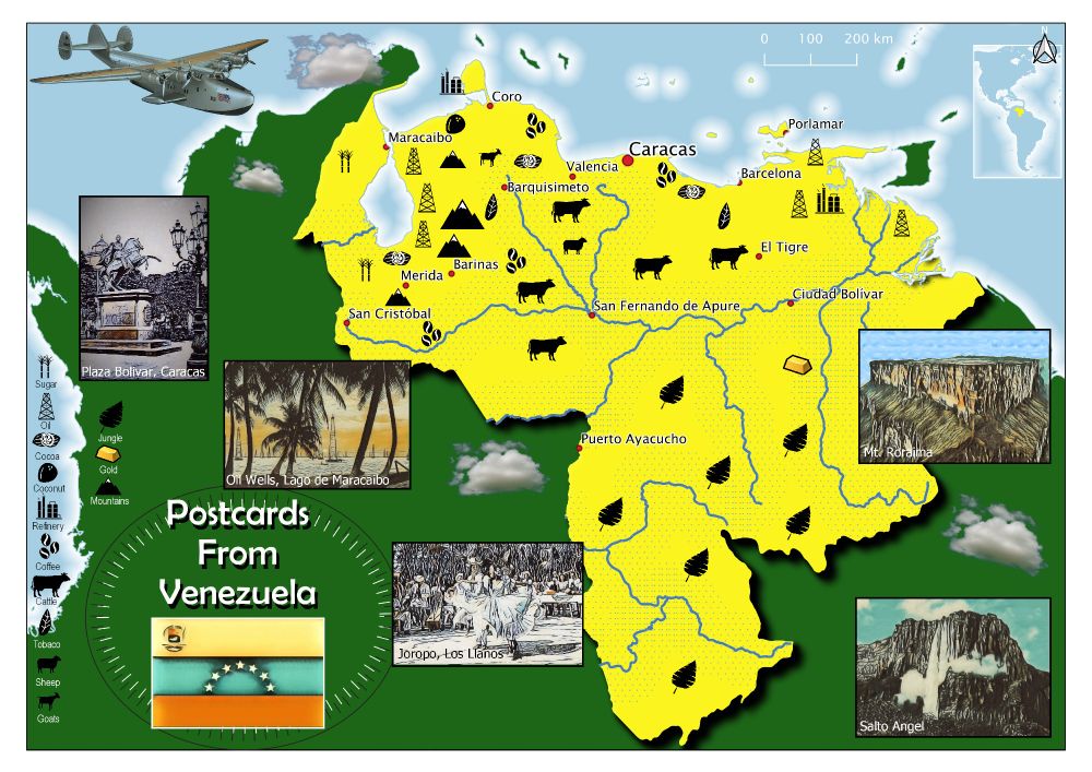
November 10, 2025 at 8:16 AM
#30daymapchallenge Day 10: Air. Inspired by a PanAm map published in 1950 and the fact that PanAm flew daily from Miami to Maracaibo in Venezuela from 1927. The first regular flights landed on the lake.
#30daymapchallenge Day 9: Analog. A map made in an analogue age: 1978. My geography teacher took what looked like a paint roller, inked it up and rolled it into my exercise book for me to complete. Subject: Plate Tectonics. Projection: Mercator!

November 9, 2025 at 9:31 AM
#30daymapchallenge Day 9: Analog. A map made in an analogue age: 1978. My geography teacher took what looked like a paint roller, inked it up and rolled it into my exercise book for me to complete. Subject: Plate Tectonics. Projection: Mercator!
#30daymapchallenge Day 8: Urban. A map of buildings in central Brighton by use. I like that the individual buildings on the Pier have separate use types - including the helter-skelter! Building footprint data from the opensource Overture Map Foundation API.

November 8, 2025 at 9:05 AM
#30daymapchallenge Day 8: Urban. A map of buildings in central Brighton by use. I like that the individual buildings on the Pier have separate use types - including the helter-skelter! Building footprint data from the opensource Overture Map Foundation API.
#30daymapchallenge Day 7: Accessibility. Public access - 'the right to roam' - to land in England is complicated and limited. Here I've mapped public access land to land use type. Only 8% of the country is accessible and 10% of that is in residential areas.

November 7, 2025 at 8:36 AM
#30daymapchallenge Day 7: Accessibility. Public access - 'the right to roam' - to land in England is complicated and limited. Here I've mapped public access land to land use type. Only 8% of the country is accessible and 10% of that is in residential areas.
#30daymapchallenge Day 6: Dimensions. This map of Venezuela includes an elevation profile of the entire country. This is based on a line of latitude centred on Pico Bolivar, the highest point of the country in the Andes.

November 6, 2025 at 8:45 AM
#30daymapchallenge Day 6: Dimensions. This map of Venezuela includes an elevation profile of the entire country. This is based on a line of latitude centred on Pico Bolivar, the highest point of the country in the Andes.
#30daymapchallenge Day 5: Earth. The climate and soil in Sussex are ideal for growing vines and sparkling wine from the county is great quality and winning prizes. Here I've mapped the vineyards to the geology of the Weald. The earth is chalk and sandstone mostly - clay avoided. Cheers!

November 5, 2025 at 8:46 AM
#30daymapchallenge Day 5: Earth. The climate and soil in Sussex are ideal for growing vines and sparkling wine from the county is great quality and winning prizes. Here I've mapped the vineyards to the geology of the Weald. The earth is chalk and sandstone mostly - clay avoided. Cheers!
#30daymapchallenge Day 4: Data: My Data. This summer I cycled from home in Brighton, UK to Rouen in France to watch the Tour de France. This was my route - mapped in Official Tour de France route map style.

November 4, 2025 at 10:36 AM
#30daymapchallenge Day 4: Data: My Data. This summer I cycled from home in Brighton, UK to Rouen in France to watch the Tour de France. This was my route - mapped in Official Tour de France route map style.
#30daymapchallenge Day 3: Polygons. Inspired by a hand made map I spotted on a pub wall. I liked the colours and hatching used to make the legend for the global map. In QGIS it's hard to generate a scheme that works automatically for adjacent countries. To be honest the original map was better...

November 3, 2025 at 8:24 AM
#30daymapchallenge Day 3: Polygons. Inspired by a hand made map I spotted on a pub wall. I liked the colours and hatching used to make the legend for the global map. In QGIS it's hard to generate a scheme that works automatically for adjacent countries. To be honest the original map was better...
#30daymapchallenge Day 2: Lines. I got obsessed with Portolon Charts a while back so decided to have a go and make one in GIS - antique style. They are defined by their rhumblines. The intersections of those lines is quite messy so I can see why the mapmakers of old put a rose over them.

November 2, 2025 at 9:58 AM
#30daymapchallenge Day 2: Lines. I got obsessed with Portolon Charts a while back so decided to have a go and make one in GIS - antique style. They are defined by their rhumblines. The intersections of those lines is quite messy so I can see why the mapmakers of old put a rose over them.