


Daniel Swain
@weatherwest.bsky.social
Weather and climate scientist focused on extreme events like floods, droughts, & wildfires on a warming planet. www.weatherwest.com
A calm & quiescent Thanksgiving Day in CA, weather-wise, with warm & mostly sunny conditions outside of Central Valley & parts of North Bay--where widespread tule fog is keeping things chillier (as predicted). Temps into 70s SoCal & 60s NorCal above fog layer (50s beneath). #CAwx

November 27, 2025 at 8:04 PM
A calm & quiescent Thanksgiving Day in CA, weather-wise, with warm & mostly sunny conditions outside of Central Valley & parts of North Bay--where widespread tule fog is keeping things chillier (as predicted). Temps into 70s SoCal & 60s NorCal above fog layer (50s beneath). #CAwx
Join us on Wed, Dec 10 for a live virtual discussion on hurricane intensification in a warming climate, including the science involved & implications for insurance industry. This Reask-sponsored event will be open to public (see registration link below). reask.earth/webinar-...

November 26, 2025 at 6:07 PM
Join us on Wed, Dec 10 for a live virtual discussion on hurricane intensification in a warming climate, including the science involved & implications for insurance industry. This Reask-sponsored event will be open to public (see registration link below). reask.earth/webinar-...
Reposted by Daniel Swain

We've posted a quick summary of the two storm systems that resulted in multi-day precipitation events over the Southwestern US between 16-19 Nov & 20-23 Nov. Read more here: cw3e.ucsd.edu/wp-content/u...

November 25, 2025 at 11:49 PM
We've posted a quick summary of the two storm systems that resulted in multi-day precipitation events over the Southwestern US between 16-19 Nov & 20-23 Nov. Read more here: cw3e.ucsd.edu/wp-content/u...
Reposted by Daniel Swain
A "high variance" precip pattern may setting up for SoCal in Dec--meaning that high-amplitude flow (i.e., wavy jet stream and pronounced/persistent ridges/troughs) will set up in a place that could either bring big, wet storms...or otherwise uneventful cool, dry air. Outcome TBD!

November 24, 2025 at 5:08 PM
A "high variance" precip pattern may setting up for SoCal in Dec--meaning that high-amplitude flow (i.e., wavy jet stream and pronounced/persistent ridges/troughs) will set up in a place that could either bring big, wet storms...or otherwise uneventful cool, dry air. Outcome TBD!
Reposted by Daniel Swain
After this week, uncertainty reigns. A major stratospheric warming event and subsequent stratospheric polar vortex disruption *may* cause a pattern change-up in early Dec, but details (and even big picture) remain quite murky. In general, looks potentially active in California...

November 24, 2025 at 5:08 PM
After this week, uncertainty reigns. A major stratospheric warming event and subsequent stratospheric polar vortex disruption *may* cause a pattern change-up in early Dec, but details (and even big picture) remain quite murky. In general, looks potentially active in California...
Reposted by Daniel Swain
Parts of the SF North Bay Area could also stay a bit chilly as fog "spills" westward from the Valley through the Carquinez Strait. But away from the CV and above the inversion, it'll be quite warm and sunny! Expect 60s in NorCal foothills/mtns and 70s (or warmer) SoCal. #CAwx

November 24, 2025 at 5:08 PM
Parts of the SF North Bay Area could also stay a bit chilly as fog "spills" westward from the Valley through the Carquinez Strait. But away from the CV and above the inversion, it'll be quite warm and sunny! Expect 60s in NorCal foothills/mtns and 70s (or warmer) SoCal. #CAwx
Reposted by Daniel Swain
This week, extensive areas of fog (sometimes quite dense) will prevail in CA Central Valley--even into PM hours. This is a classic "tule fog" setup, w/a strong temperature inversion under a ridge trapping sfc moisture in CV but keeping nearby hills & mountains balmily warm/sunny.

November 24, 2025 at 5:08 PM
This week, extensive areas of fog (sometimes quite dense) will prevail in CA Central Valley--even into PM hours. This is a classic "tule fog" setup, w/a strong temperature inversion under a ridge trapping sfc moisture in CV but keeping nearby hills & mountains balmily warm/sunny.
Reposted by Daniel Swain
Following a very wet period in Southern California (even breaking some records for Nov and season-to-date precip!), dry and much warmer conditions will prevail this week. In fact, Thanksgiving will be quite mild & dry nearly U.S. West-wide EXCEPT for the Central Valley... #CAwx
November 24, 2025 at 5:08 PM
Following a very wet period in Southern California (even breaking some records for Nov and season-to-date precip!), dry and much warmer conditions will prevail this week. In fact, Thanksgiving will be quite mild & dry nearly U.S. West-wide EXCEPT for the Central Valley... #CAwx
Following a very wet period in Southern California (even breaking some records for Nov and season-to-date precip!), dry and much warmer conditions will prevail this week. In fact, Thanksgiving will be quite mild & dry nearly U.S. West-wide EXCEPT for the Central Valley... #CAwx
November 24, 2025 at 5:08 PM
Following a very wet period in Southern California (even breaking some records for Nov and season-to-date precip!), dry and much warmer conditions will prevail this week. In fact, Thanksgiving will be quite mild & dry nearly U.S. West-wide EXCEPT for the Central Valley... #CAwx
Reposted by Daniel Swain
It did not go as planned, but it DID go as expected ...
insideclimatenews.org/news/2211202...
insideclimatenews.org/news/2211202...

COP30 Backpedals on Climate Action - Inside Climate News
BELÉM, Brazil—After negotiators at COP30 retreated from meaningful climate action by failing to specifically mention the need to stop using fossil fuels in the final conference documents published Sat...
insideclimatenews.org
November 22, 2025 at 11:07 PM
It did not go as planned, but it DID go as expected ...
insideclimatenews.org/news/2211202...
insideclimatenews.org/news/2211202...
Reposted by Daniel Swain

Here's the GVP page of Hayli Gubbi in Ethiopia: volcano.si.edu/volcano.cfm?.... Plume from the eruption can be seen in this Aqua/MODIS image cross the Red Sea to the Arabian Peninsula. #eruption #volcano

November 23, 2025 at 6:26 PM
Here's the GVP page of Hayli Gubbi in Ethiopia: volcano.si.edu/volcano.cfm?.... Plume from the eruption can be seen in this Aqua/MODIS image cross the Red Sea to the Arabian Peninsula. #eruption #volcano
Reposted by Daniel Swain
Editors! @ucanr.edu is hiring an editor for peer-reviewed materials produced by @uofcalifornia.bsky.social scientists. First application review date is Dec. 5
@sciencewriters.org See careerspub.universityofcalifornia.edu/psc/ucanr/EM... 📚https://ucanr.edu/careers
@sciencewriters.org See careerspub.universityofcalifornia.edu/psc/ucanr/EM... 📚https://ucanr.edu/careers

Careers | UC Agriculture and Natural Resources
Working at UC Agriculture and Natural Resources Collaborating to solve problems. Connecting to serve communities.UC Agriculture and Natural Resources brings UC information and practices to all 58 Cal...
ucanr.edu
November 23, 2025 at 1:55 AM
Editors! @ucanr.edu is hiring an editor for peer-reviewed materials produced by @uofcalifornia.bsky.social scientists. First application review date is Dec. 5
@sciencewriters.org See careerspub.universityofcalifornia.edu/psc/ucanr/EM... 📚https://ucanr.edu/careers
@sciencewriters.org See careerspub.universityofcalifornia.edu/psc/ucanr/EM... 📚https://ucanr.edu/careers
Reposted by Daniel Swain

Join #UCANR climate scientist @weatherwest.bsky.social today at 12:00 PM PT for a 30-minute pop-up lunch-hour livestream as he unpacks last night’s intense “training” thunderstorms that brought heavy rain & localized flooding across Orange & LA counties.
Tune in to learn what happened and why.
Tune in to learn what happened and why.
I'm squeezing in a mini (30 min!) pop-up "lunch hour livestream" later today (noon PT) to discuss last night's localized but torrential downpours (and notable urban flooding) due to "training" convective cells in Orange and LA counties. #CAwx #LArain

A pop-up discussion of last night's torrential downpours & urban flooding in Orange & LA Counties - YouTube
The latest in a recurring series of live, virtual, & interactive "office hours" hosted by Dr. Daniel Swain on various topics related to extreme #weather and...
www.youtube.com
November 21, 2025 at 6:38 PM
Join #UCANR climate scientist @weatherwest.bsky.social today at 12:00 PM PT for a 30-minute pop-up lunch-hour livestream as he unpacks last night’s intense “training” thunderstorms that brought heavy rain & localized flooding across Orange & LA counties.
Tune in to learn what happened and why.
Tune in to learn what happened and why.
I'm squeezing in a mini (30 min!) pop-up "lunch hour livestream" later today (noon PT) to discuss last night's localized but torrential downpours (and notable urban flooding) due to "training" convective cells in Orange and LA counties. #CAwx #LArain
A pop-up discussion of last night's torrential downpours & urban flooding in Orange & LA Counties - YouTube
The latest in a recurring series of live, virtual, & interactive "office hours" hosted by Dr. Daniel Swain on various topics related to extreme #weather and...
www.youtube.com
November 21, 2025 at 4:55 PM
A combination of unstable air and favorable vertical wind profile (i.e., colder air aloft advecting over warmer sfc) associated with offshore low will bring an isolated SoCal flash flood threat overnight due to "training" convective cells (like the one over OC right now). #CAwx
November 21, 2025 at 6:11 AM
A combination of unstable air and favorable vertical wind profile (i.e., colder air aloft advecting over warmer sfc) associated with offshore low will bring an isolated SoCal flash flood threat overnight due to "training" convective cells (like the one over OC right now). #CAwx
Reposted by Daniel Swain
Longer term, it still looks like a quasi-stationary wave pattern will develop over North Pacific & North America by late Nov, likely linked to polar vortex disruption. A pronounced ridge will develop over far eastern Pacific, and a deep trough over interior West/central U.S.

November 20, 2025 at 4:21 AM
Longer term, it still looks like a quasi-stationary wave pattern will develop over North Pacific & North America by late Nov, likely linked to polar vortex disruption. A pronounced ridge will develop over far eastern Pacific, and a deep trough over interior West/central U.S.
Reposted by Daniel Swain
The metaphor is self-aware. 🫠
"The fire quickly spread to neighboring pavilions, said Samuel Rubin, one of the people in charge of an entertainment and culture pavilion. He said nearby pavilions include many of the Africa pavilions and one aimed at youth."
www.washingtonpost.com/world/2025/1...
"The fire quickly spread to neighboring pavilions, said Samuel Rubin, one of the people in charge of an entertainment and culture pavilion. He said nearby pavilions include many of the Africa pavilions and one aimed at youth."
www.washingtonpost.com/world/2025/1...

Fire prompts evacuations at UN climate talks in Brazil, but officials say no one hurt
Officials say a fire that spread through pavilions being used for U.N. climate talks in Brazil has prompted evacuations on the next-to-last day of the conference, but nobody was hurt
www.washingtonpost.com
November 20, 2025 at 8:00 PM
The metaphor is self-aware. 🫠
"The fire quickly spread to neighboring pavilions, said Samuel Rubin, one of the people in charge of an entertainment and culture pavilion. He said nearby pavilions include many of the Africa pavilions and one aimed at youth."
www.washingtonpost.com/world/2025/1...
"The fire quickly spread to neighboring pavilions, said Samuel Rubin, one of the people in charge of an entertainment and culture pavilion. He said nearby pavilions include many of the Africa pavilions and one aimed at youth."
www.washingtonpost.com/world/2025/1...
Reposted by Daniel Swain
Quite a metaphor. 👀
"The blaze [sent] panicked delegates racing to evacuate...rain from a torrential downpour leaked into the meeting spaces...There were complaints about food shortages, & the air-conditioning struggled to keep up with the high heat..."
"The blaze [sent] panicked delegates racing to evacuate...rain from a torrential downpour leaked into the meeting spaces...There were complaints about food shortages, & the air-conditioning struggled to keep up with the high heat..."

Fire Breaks Out at COP30 Climate Talks in Brazil
Delegates were evacuated from the conference venue, where thousands from nearly 200 countries had gathered.
www.nytimes.com
November 20, 2025 at 7:36 PM
Quite a metaphor. 👀
"The blaze [sent] panicked delegates racing to evacuate...rain from a torrential downpour leaked into the meeting spaces...There were complaints about food shortages, & the air-conditioning struggled to keep up with the high heat..."
"The blaze [sent] panicked delegates racing to evacuate...rain from a torrential downpour leaked into the meeting spaces...There were complaints about food shortages, & the air-conditioning struggled to keep up with the high heat..."
Fire Breaks Out at COP30 Climate Talks in Brazil
Delegates were evacuated from the conference venue, where thousands from nearly 200 countries had gathered.
www.nytimes.com
November 20, 2025 at 7:36 PM
Quite a metaphor. 👀
"The blaze [sent] panicked delegates racing to evacuate...rain from a torrential downpour leaked into the meeting spaces...There were complaints about food shortages, & the air-conditioning struggled to keep up with the high heat..."
"The blaze [sent] panicked delegates racing to evacuate...rain from a torrential downpour leaked into the meeting spaces...There were complaints about food shortages, & the air-conditioning struggled to keep up with the high heat..."
Reposted by Daniel Swain
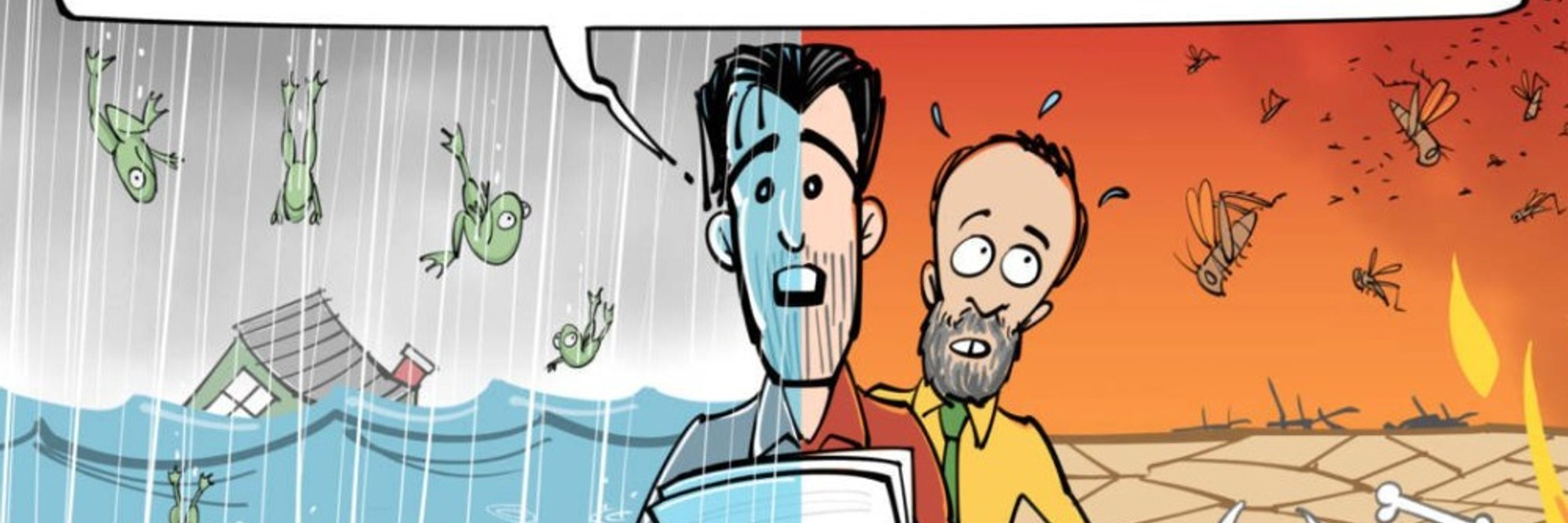
In case you missed it: my follow-up video op-ed responding to ongoing conversations surrounding the COP30 climate conference and seemingly widespread misconception regarding how harmful 2-3°C of global warming would actually be for human societies, economies, and global ecosystems.
I recorded a short video op-ed to help cut through the noise surrounding the ongoing COP30 climate conference. In short: now is not the time to scale back our efforts to address climate change--quite the opposite, as the intensifying consequences have never been clearer.

Now is not the time to scale back efforts to address climate change!
As the #COP30 #climate conference unfolds, competing narratives from scientists, politicians, and influential billionaires swirl. In this brief video op-ed, climate scientist Daniel Swain cuts through the noise to explain why the present moment is an especially consequential one--including where wer
www.youtube.com
November 17, 2025 at 5:18 PM
In case you missed it: my follow-up video op-ed responding to ongoing conversations surrounding the COP30 climate conference and seemingly widespread misconception regarding how harmful 2-3°C of global warming would actually be for human societies, economies, and global ecosystems.
More active weather in SoCal Thu! This will be a colder and convectively-active system, & also faster moving that the last. This means a burst of locally heavy precip, along w/some t-storms & higher mtn snow, are likely, but rain accumulation will be less than wknd storm. #CAwx

November 20, 2025 at 4:21 AM
More active weather in SoCal Thu! This will be a colder and convectively-active system, & also faster moving that the last. This means a burst of locally heavy precip, along w/some t-storms & higher mtn snow, are likely, but rain accumulation will be less than wknd storm. #CAwx
Reposted by Daniel Swain

Hurricane Melissa produced the fastest hurricane winds to be recorded by a dropsonde, verified by reviewing data at NSF NCAR! Hurricane Melissa’s 252 mph wind gust surpassed the previous record from Typhoon Megi over the Western Pacific in 2010, where a dropsonde measured wind gusts of 248 mph.

November 19, 2025 at 5:37 PM
Hurricane Melissa produced the fastest hurricane winds to be recorded by a dropsonde, verified by reviewing data at NSF NCAR! Hurricane Melissa’s 252 mph wind gust surpassed the previous record from Typhoon Megi over the Western Pacific in 2010, where a dropsonde measured wind gusts of 248 mph.
Reposted by Daniel Swain

A view of this year's extreme sea surface temperatures and recent warming across the North Pacific... 🌊
This graph shows the average for a band across the midlatitudes for every average January-October period from 1854-2025 using ERSSTv5 data.
This graph shows the average for a band across the midlatitudes for every average January-October period from 1854-2025 using ERSSTv5 data.

November 19, 2025 at 1:28 AM
A view of this year's extreme sea surface temperatures and recent warming across the North Pacific... 🌊
This graph shows the average for a band across the midlatitudes for every average January-October period from 1854-2025 using ERSSTv5 data.
This graph shows the average for a band across the midlatitudes for every average January-October period from 1854-2025 using ERSSTv5 data.
In case you missed it: my follow-up video op-ed responding to ongoing conversations surrounding the COP30 climate conference and seemingly widespread misconception regarding how harmful 2-3°C of global warming would actually be for human societies, economies, and global ecosystems.
I recorded a short video op-ed to help cut through the noise surrounding the ongoing COP30 climate conference. In short: now is not the time to scale back our efforts to address climate change--quite the opposite, as the intensifying consequences have never been clearer.
Now is not the time to scale back efforts to address climate change!
As the #COP30 #climate conference unfolds, competing narratives from scientists, politicians, and influential billionaires swirl. In this brief video op-ed, climate scientist Daniel Swain cuts through the noise to explain why the present moment is an especially consequential one--including where wer
www.youtube.com
November 17, 2025 at 5:18 PM
In case you missed it: my follow-up video op-ed responding to ongoing conversations surrounding the COP30 climate conference and seemingly widespread misconception regarding how harmful 2-3°C of global warming would actually be for human societies, economies, and global ecosystems.
An active weather pattern will continue this week across California, with widespread moderate rainfall. Some local flooding issues could occur in areas that saw heavier rain last week, but overall concern is low. #CAwx

November 17, 2025 at 4:53 PM
An active weather pattern will continue this week across California, with widespread moderate rainfall. Some local flooding issues could occur in areas that saw heavier rain last week, but overall concern is low. #CAwx