


Tennessee Severe Weather Alerts
@wxthingsvralerts.bsky.social
WxThing.com powers this page. Providing real-time weather alerts to social media pages. Learn more at wxthing.com. This account posts Severe T-Storm Warnings and Tornado Warnings for TN. Using WxThing AI.
Pinned
TheWeatherThing - Automated Weather Alerts
Get real-time National Weather Service alerts posted directly to your Facebook and Bluesky pages. TheWeatherThing keeps your community safe and informed.
WxThing.com
This page posts real-time severe weather alerts for Tennessee, including Severe T-Storm Warnings, Tornado Warnings, Strong Storm Alerts, and flood alerts. All posts are powered by WxThing AI. Visit WxThing.com for more!
Severe thunderstorm warning in effect until further notice. A storm near Smyrna is moving east at 40 mph, bringing 60 mph wind gusts and quarter-sized hail. Expect potential damage to vehicles, roofs, and trees. Areas affected include Murfreesboro, Smyrna, and La Vergne. A tornado watch is also in

November 7, 2025 at 11:13 PM
Severe thunderstorm warning in effect until further notice. A storm near Smyrna is moving east at 40 mph, bringing 60 mph wind gusts and quarter-sized hail. Expect potential damage to vehicles, roofs, and trees. Areas affected include Murfreesboro, Smyrna, and La Vergne. A tornado watch is also in
Severe thunderstorm warning in effect until 6 PM CST for southeastern Davidson, Rutherford, east central Williamson, and southern Wilson counties. Expect 60 mph winds and quarter-sized hail. Damage to vehicles, roofs, and trees is likely. Move to an interior room on the lowest floor for safety. Ke

November 7, 2025 at 10:56 PM
Severe thunderstorm warning in effect until 6 PM CST for southeastern Davidson, Rutherford, east central Williamson, and southern Wilson counties. Expect 60 mph winds and quarter-sized hail. Damage to vehicles, roofs, and trees is likely. Move to an interior room on the lowest floor for safety. Ke
A severe thunderstorm is moving east at 35 mph, currently near Antioch. Expect ping pong ball-sized hail and 60 mph wind gusts.
Impacted areas include Franklin, Brentwood, and La Vergne. Damage to roofs, siding, and vehicles is likely.
For safety, move to an interior room on the lowest floor.
Impacted areas include Franklin, Brentwood, and La Vergne. Damage to roofs, siding, and vehicles is likely.
For safety, move to an interior room on the lowest floor.

November 7, 2025 at 10:48 PM
A severe thunderstorm is moving east at 35 mph, currently near Antioch. Expect ping pong ball-sized hail and 60 mph wind gusts.
Impacted areas include Franklin, Brentwood, and La Vergne. Damage to roofs, siding, and vehicles is likely.
For safety, move to an interior room on the lowest floor.
Impacted areas include Franklin, Brentwood, and La Vergne. Damage to roofs, siding, and vehicles is likely.
For safety, move to an interior room on the lowest floor.
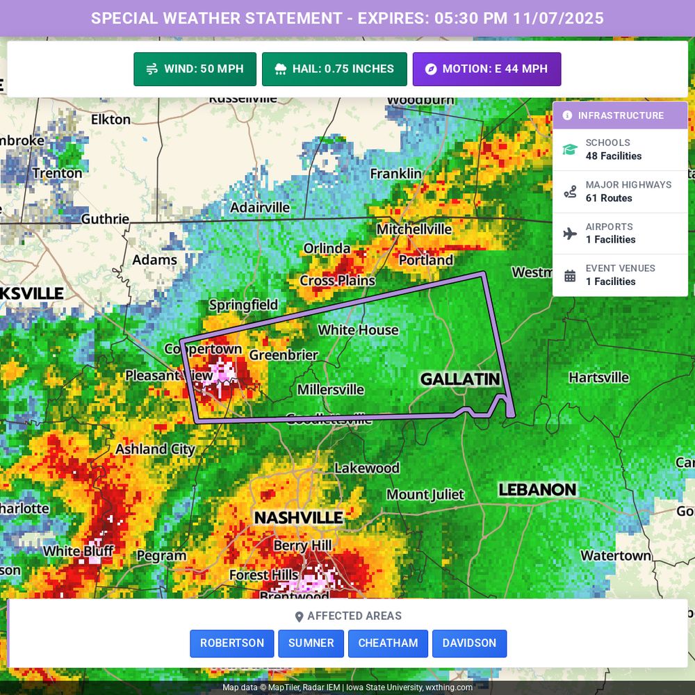
A strong thunderstorm is moving east at 45 mph near Coopertown, affecting areas like Gallatin and Springfield. Expect wind gusts up to 50 mph and penny-sized hail. These conditions could down tree limbs and damage vegetation. If you're outdoors, please seek shelter. A Tornado Watch is in effect un
November 7, 2025 at 10:45 PM
A strong thunderstorm is moving east at 45 mph near Coopertown, affecting areas like Gallatin and Springfield. Expect wind gusts up to 50 mph and penny-sized hail. These conditions could down tree limbs and damage vegetation. If you're outdoors, please seek shelter. A Tornado Watch is in effect un
A severe thunderstorm is moving east at 45 mph, currently near Franklin. Expect ping pong ball-sized hail and wind gusts up to 60 mph.
Impacted areas include Franklin, Nashville, and Brentwood. Damage to roofs, siding, and vehicles is likely.
For safety, move to an interior room on the lowest
Impacted areas include Franklin, Nashville, and Brentwood. Damage to roofs, siding, and vehicles is likely.
For safety, move to an interior room on the lowest

November 7, 2025 at 10:38 PM
A severe thunderstorm is moving east at 45 mph, currently near Franklin. Expect ping pong ball-sized hail and wind gusts up to 60 mph.
Impacted areas include Franklin, Nashville, and Brentwood. Damage to roofs, siding, and vehicles is likely.
For safety, move to an interior room on the lowest
Impacted areas include Franklin, Nashville, and Brentwood. Damage to roofs, siding, and vehicles is likely.
For safety, move to an interior room on the lowest
A severe thunderstorm is moving east at 35 mph, currently located over Pegram. Expect ping pong ball-sized hail and wind gusts up to 60 mph.
Impacted areas include Ashland City, Kingston Springs, Pegram, and Fairview.
For safety, move to an interior room on the lowest floor. A Tornado Watch is
Impacted areas include Ashland City, Kingston Springs, Pegram, and Fairview.
For safety, move to an interior room on the lowest floor. A Tornado Watch is

November 7, 2025 at 10:19 PM
A severe thunderstorm is moving east at 35 mph, currently located over Pegram. Expect ping pong ball-sized hail and wind gusts up to 60 mph.
Impacted areas include Ashland City, Kingston Springs, Pegram, and Fairview.
For safety, move to an interior room on the lowest floor. A Tornado Watch is
Impacted areas include Ashland City, Kingston Springs, Pegram, and Fairview.
For safety, move to an interior room on the lowest floor. A Tornado Watch is
A strong thunderstorm is moving east at 45 mph, located 11 miles west of Centerville. Expect wind gusts up to 40 mph and half-inch hail. This could cause minor damage to vegetation and blow around unsecured objects. Areas affected include Centerville and Nunnelly. If you're outdoors, seek shelter

November 7, 2025 at 10:19 PM
A strong thunderstorm is moving east at 45 mph, located 11 miles west of Centerville. Expect wind gusts up to 40 mph and half-inch hail. This could cause minor damage to vegetation and blow around unsecured objects. Areas affected include Centerville and Nunnelly. If you're outdoors, seek shelter
Severe thunderstorm warning for Davidson, northern Williamson, and southeastern Cheatham counties until 5:15 PM CST. A storm near Kingston Springs is moving east at 35 mph, bringing ping pong ball-sized hail and 60 mph winds. Expect damage to roofs, windows, and trees. Seek shelter in an interior

November 7, 2025 at 10:16 PM
Severe thunderstorm warning for Davidson, northern Williamson, and southeastern Cheatham counties until 5:15 PM CST. A storm near Kingston Springs is moving east at 35 mph, bringing ping pong ball-sized hail and 60 mph winds. Expect damage to roofs, windows, and trees. Seek shelter in an interior
A strong thunderstorm is moving east at 30 mph near Gainesboro, bringing wind gusts up to 50 mph and half-inch hail. Expect potential minor hail damage and gusty winds that could down tree limbs or move unsecured items. Areas affected include Livingston, Gainesboro, Algood, Rickman, and Cummins Fa

November 7, 2025 at 10:03 PM
A strong thunderstorm is moving east at 30 mph near Gainesboro, bringing wind gusts up to 50 mph and half-inch hail. Expect potential minor hail damage and gusty winds that could down tree limbs or move unsecured items. Areas affected include Livingston, Gainesboro, Algood, Rickman, and Cummins Fa
A severe thunderstorm warning is in effect until 4:30 PM CST for Dickson, Cheatham, and northwestern Williamson counties. Expect 60 mph winds and quarter-sized hail. Damage to vehicles, roofs, and trees is likely. Move to an interior room on the lowest floor for safety. A tornado watch is also in

November 7, 2025 at 9:40 PM
A severe thunderstorm warning is in effect until 4:30 PM CST for Dickson, Cheatham, and northwestern Williamson counties. Expect 60 mph winds and quarter-sized hail. Damage to vehicles, roofs, and trees is likely. Move to an interior room on the lowest floor for safety. A tornado watch is also in
A severe thunderstorm is moving east at 50 mph, currently near McEwen. Expect 60 mph wind gusts and quarter-sized hail. Locations impacted include Dickson, Waverly, and Erin. Hail may damage vehicles, and winds could harm roofs and trees. For safety, move to an interior room on the lowest floor. h

November 7, 2025 at 9:23 PM
A severe thunderstorm is moving east at 50 mph, currently near McEwen. Expect 60 mph wind gusts and quarter-sized hail. Locations impacted include Dickson, Waverly, and Erin. Hail may damage vehicles, and winds could harm roofs and trees. For safety, move to an interior room on the lowest floor. h
A severe thunderstorm warning is in effect until 3:45 PM CST for northwestern Dickson, Houston, and northern Humphreys counties. Expect 60 mph winds and quarter-sized hail, with potential damage to vehicles and property. The storm is moving east at 50 mph. Seek shelter in an interior room on the l

November 7, 2025 at 9:09 PM
A severe thunderstorm warning is in effect until 3:45 PM CST for northwestern Dickson, Houston, and northern Humphreys counties. Expect 60 mph winds and quarter-sized hail, with potential damage to vehicles and property. The storm is moving east at 50 mph. Seek shelter in an interior room on the l
A strong thunderstorm is moving northeast at 45 mph, located 10 miles west of Tennessee Ridge. Expect wind gusts up to 40 mph and nickel-sized hail. This could cause minor damage to vegetation and knock down tree limbs. Areas affected include Dover, Erin, and Cumberland City. If you're outdoors, p

November 7, 2025 at 8:54 PM
A strong thunderstorm is moving northeast at 45 mph, located 10 miles west of Tennessee Ridge. Expect wind gusts up to 40 mph and nickel-sized hail. This could cause minor damage to vegetation and knock down tree limbs. Areas affected include Dover, Erin, and Cumberland City. If you're outdoors, p
A strong thunderstorm is moving east at 45 mph, located 8 miles northeast of Springville. Expect winds over 30 mph and nickel-sized hail. This may cause minor damage to vegetation and blow around unsecured items. Areas affected include Camden, Springville, and Big Sandy. If you're outdoors, seek s

November 7, 2025 at 8:47 PM
A strong thunderstorm is moving east at 45 mph, located 8 miles northeast of Springville. Expect winds over 30 mph and nickel-sized hail. This may cause minor damage to vegetation and blow around unsecured items. Areas affected include Camden, Springville, and Big Sandy. If you're outdoors, seek s
Alert: Special Weather Statement: Moderate. Affects Cherokee, Clay, Scott. Expires at N/A. https://tinyurl.com/264dj5kk

November 4, 2025 at 6:27 AM
Alert: Special Weather Statement: Moderate. Affects Cherokee, Clay, Scott. Expires at N/A. https://tinyurl.com/264dj5kk
A strong thunderstorm is moving northeast at 20 mph, located 8 miles west of Sevierville. Expect winds over 30 mph and half-inch hail. This could cause minor damage to vegetation and knock down tree limbs. Areas affected include Knoxville, Sevierville, and Jefferson City. If you're outdoors, pleas

November 2, 2025 at 8:32 PM
A strong thunderstorm is moving northeast at 20 mph, located 8 miles west of Sevierville. Expect winds over 30 mph and half-inch hail. This could cause minor damage to vegetation and knock down tree limbs. Areas affected include Knoxville, Sevierville, and Jefferson City. If you're outdoors, pleas
Showers are moving north at 20 mph, bringing pea-sized hail to areas including Chattanooga, Dunlap, and Signal Mountain. Minor hail damage to vegetation is possible. If you're outdoors, please seek shelter indoors. https://tinyurl.com/25u6mlq9

November 2, 2025 at 7:27 PM
Showers are moving north at 20 mph, bringing pea-sized hail to areas including Chattanooga, Dunlap, and Signal Mountain. Minor hail damage to vegetation is possible. If you're outdoors, please seek shelter indoors. https://tinyurl.com/25u6mlq9
Alert: Special Weather Statement: Moderate. Affects Cherokee, Clay, Scott. Expires at N/A. https://tinyurl.com/2y9d9xz5

November 1, 2025 at 12:08 PM
Alert: Special Weather Statement: Moderate. Affects Cherokee, Clay, Scott. Expires at N/A. https://tinyurl.com/2y9d9xz5
Gusty showers are moving east at 25 mph near Jasper, bringing pea-sized hail. Minor damage to vegetation is possible. Areas affected include Chattanooga, Jasper, Kimball, Lookout Mountain, and New Hope. If you're outdoors, please seek shelter inside a building. https://tinyurl.com/27o9qdua

October 29, 2025 at 10:00 PM
Gusty showers are moving east at 25 mph near Jasper, bringing pea-sized hail. Minor damage to vegetation is possible. Areas affected include Chattanooga, Jasper, Kimball, Lookout Mountain, and New Hope. If you're outdoors, please seek shelter inside a building. https://tinyurl.com/27o9qdua
Strong thunderstorms are moving east at 20 mph, affecting Huntsville, Winchester, Fayetteville, and surrounding areas. Expect pea-sized hail, which may cause minor damage to vegetation. If you’re outdoors, please seek shelter indoors until the storms pass. https://tinyurl.com/23bpae6z

October 29, 2025 at 8:39 PM
Strong thunderstorms are moving east at 20 mph, affecting Huntsville, Winchester, Fayetteville, and surrounding areas. Expect pea-sized hail, which may cause minor damage to vegetation. If you’re outdoors, please seek shelter indoors until the storms pass. https://tinyurl.com/23bpae6z
A strong thunderstorm is moving east at 75 mph near Baneberry, affecting Greeneville, Newport, and Tusculum. Expect wind gusts up to 40 mph and nickel-sized hail. These conditions may cause minor damage to vegetation and blow around unsecured objects. If you're outdoors, seek shelter indoors. Stay

October 21, 2025 at 6:41 PM
A strong thunderstorm is moving east at 75 mph near Baneberry, affecting Greeneville, Newport, and Tusculum. Expect wind gusts up to 40 mph and nickel-sized hail. These conditions may cause minor damage to vegetation and blow around unsecured objects. If you're outdoors, seek shelter indoors. Stay
A strong thunderstorm is moving east at 70 mph, impacting areas like Knoxville, Morristown, and Sevierville. Expect wind gusts up to 50 mph and nickel-sized hail. Gusty winds may down tree limbs and move unsecured objects. If you're outdoors, please seek shelter indoors. Stay safe! https://tinyurl

October 21, 2025 at 6:13 PM
A strong thunderstorm is moving east at 70 mph, impacting areas like Knoxville, Morristown, and Sevierville. Expect wind gusts up to 50 mph and nickel-sized hail. Gusty winds may down tree limbs and move unsecured objects. If you're outdoors, please seek shelter indoors. Stay safe! https://tinyurl
A strong thunderstorm is moving east at 65 mph near Loudon, bringing wind gusts up to 50 mph and pea-sized hail. Expect possible minor damage to vegetation and flying debris. Areas affected include Knoxville, Maryville, and Gatlinburg. If you're outside, please seek shelter indoors. https://tinyur

October 21, 2025 at 5:46 PM
A strong thunderstorm is moving east at 65 mph near Loudon, bringing wind gusts up to 50 mph and pea-sized hail. Expect possible minor damage to vegetation and flying debris. Areas affected include Knoxville, Maryville, and Gatlinburg. If you're outside, please seek shelter indoors. https://tinyur
A strong thunderstorm is moving east at 70 mph, currently near Decherd. Expect wind gusts up to 40 mph and pea-sized hail. This could cause minor damage to vegetation and blow around unsecured objects. Areas affected include Winchester, Lynchburg, and Estill Springs. If you're outside, please seek

October 21, 2025 at 4:16 PM
A strong thunderstorm is moving east at 70 mph, currently near Decherd. Expect wind gusts up to 40 mph and pea-sized hail. This could cause minor damage to vegetation and blow around unsecured objects. Areas affected include Winchester, Lynchburg, and Estill Springs. If you're outside, please seek
Gusty showers are moving east at 50 mph, bringing wind gusts of 50 to 55 mph. Expect potential tree limb damage and flying debris in Johnson City, Kingsport, and Bristol. If you're outdoors, please seek shelter indoors for safety. https://tinyurl.com/287an8p6

October 19, 2025 at 8:14 PM
Gusty showers are moving east at 50 mph, bringing wind gusts of 50 to 55 mph. Expect potential tree limb damage and flying debris in Johnson City, Kingsport, and Bristol. If you're outdoors, please seek shelter indoors for safety. https://tinyurl.com/287an8p6