


National Zoning Atlas
@zoningatlas.bsky.social
The National Zoning Atlas is a collaborative of researchers digitizing, demystifying, & democratizing ~30,000 U.S. zoning codes. Explore our interactive map at zoningatlas.org/atlas.
Pinned

EXPLORE THE ATLAS — National Zoning Atlas
zoningatlas.org
👋 Bluesky! We’re the National Zoning Atlas, a dynamic research collaborative working to digitize, demystify, and democratize all America's #zoningcodes.
Explore our interactive map at zoningatlas.org/atlas.
Explore our interactive map at zoningatlas.org/atlas.
Who wants to learn about slices? 🔪 No, not pizza slices.🍕 Zoning slices! 🤓
Let us explain.
🧵👇
Let us explain.
🧵👇


November 14, 2025 at 2:58 PM
Who wants to learn about slices? 🔪 No, not pizza slices.🍕 Zoning slices! 🤓
Let us explain.
🧵👇
Let us explain.
🧵👇
🚨Milestone alert🚨: The NZA has officially read over 1 MILLION pages of zoning text!
📄📄📄📄📄📄📄📄📄📄📄📄📄📄📄📄📄📄📄📄📄📄📄📄📄📄📄📄📄
Our team is in the midst of wrapping up major work in CA, UT, ME, & NC—turning dense, local, LONG codes into open, accessible data. Check out the progress at zoningatlas.org/atlas.
📄📄📄📄📄📄📄📄📄📄📄📄📄📄📄📄📄📄📄📄📄📄📄📄📄📄📄📄📄
Our team is in the midst of wrapping up major work in CA, UT, ME, & NC—turning dense, local, LONG codes into open, accessible data. Check out the progress at zoningatlas.org/atlas.
EXPLORE THE ATLAS — National Zoning Atlas
The National Zoning Atlas illuminates critical information about the land use regulations that shape our lives. Explore zoning conditions for the thousands of cities, towns, counties, and other jurisd...
zoningatlas.org
November 11, 2025 at 2:34 PM
🚨Milestone alert🚨: The NZA has officially read over 1 MILLION pages of zoning text!
📄📄📄📄📄📄📄📄📄📄📄📄📄📄📄📄📄📄📄📄📄📄📄📄📄📄📄📄📄
Our team is in the midst of wrapping up major work in CA, UT, ME, & NC—turning dense, local, LONG codes into open, accessible data. Check out the progress at zoningatlas.org/atlas.
📄📄📄📄📄📄📄📄📄📄📄📄📄📄📄📄📄📄📄📄📄📄📄📄📄📄📄📄📄
Our team is in the midst of wrapping up major work in CA, UT, ME, & NC—turning dense, local, LONG codes into open, accessible data. Check out the progress at zoningatlas.org/atlas.
Hot off the heels of Virginians electing new statewide leaders, we’re releasing Zoning Report: Virginia—the first-ever comprehensive look at zoning & its impact on housing across all 321 towns, cities, & counties in VA.
www.zoningatlas.org/zoning-repor...
🧵
www.zoningatlas.org/zoning-repor...
🧵

November 6, 2025 at 4:01 PM
Hot off the heels of Virginians electing new statewide leaders, we’re releasing Zoning Report: Virginia—the first-ever comprehensive look at zoning & its impact on housing across all 321 towns, cities, & counties in VA.
www.zoningatlas.org/zoning-repor...
🧵
www.zoningatlas.org/zoning-repor...
🧵
💫✨You unlock this door with the key of imagination. Beyond it lies another dimension... a dimension of setbacks, planned unit developments, and accessory uses... a land of both shadow and substance. You’ve just crossed over into... Twilight Zoning. ✨💫
October 31, 2025 at 2:00 PM
💫✨You unlock this door with the key of imagination. Beyond it lies another dimension... a dimension of setbacks, planned unit developments, and accessory uses... a land of both shadow and substance. You’ve just crossed over into... Twilight Zoning. ✨💫
Calling all West Coast zoning enthusiasts! 🌉 Join us TODAY at 12pm PT for the next installment of our Metro Area Snapshot Series where we’ll discuss new insights into how the Bay Area zones & how advocates can use NZA tools to support ongoing reforms.
Register: us06web.zoom.us/webinar/regi...
Register: us06web.zoom.us/webinar/regi...

October 28, 2025 at 2:22 PM
Calling all West Coast zoning enthusiasts! 🌉 Join us TODAY at 12pm PT for the next installment of our Metro Area Snapshot Series where we’ll discuss new insights into how the Bay Area zones & how advocates can use NZA tools to support ongoing reforms.
Register: us06web.zoom.us/webinar/regi...
Register: us06web.zoom.us/webinar/regi...
Reposted by National Zoning Atlas

Thank you for the spotlight, @bloomberg.com! "@sarabronin.bsky.social, founder of the @zoningatlas.bsky.social, has won the Heinz Award for her ongoing project to map the land-use rules that restrict housing production." #HeinzAward
www.bloomberg.com/news/article...
www.bloomberg.com/news/article...

Mapping a Way Out of the US Housing Affordability Crisis
Sara Bronin, founder of the National Zoning Atlas, has won the Heinz Award for her ongoing project to map the land-use rules that restrict housing production.
www.bloomberg.com
October 10, 2025 at 6:14 PM
Thank you for the spotlight, @bloomberg.com! "@sarabronin.bsky.social, founder of the @zoningatlas.bsky.social, has won the Heinz Award for her ongoing project to map the land-use rules that restrict housing production." #HeinzAward
www.bloomberg.com/news/article...
www.bloomberg.com/news/article...
In a new Bloomberg CityLab interview, NZA founder @sarabronin.bsky.social & @kristoncapps.bsky.social discuss ongoing progress at the National Zoning Atlas & how it’s helping make sense of recent zoning debates from California to Connecticut.
www.bloomberg.com/news/article...
www.bloomberg.com/news/article...

Mapping a Way Out of the US Housing Affordability Crisis
Sara Bronin, founder of the National Zoning Atlas, has won the Heinz Award for her ongoing project to map the land-use rules that restrict housing production.
www.bloomberg.com
October 10, 2025 at 4:10 PM
In a new Bloomberg CityLab interview, NZA founder @sarabronin.bsky.social & @kristoncapps.bsky.social discuss ongoing progress at the National Zoning Atlas & how it’s helping make sense of recent zoning debates from California to Connecticut.
www.bloomberg.com/news/article...
www.bloomberg.com/news/article...
🎙️Calling all members of the press!
Behind every zoning code is a story about who gets to live where, & why. That’s why we're proud to launch our Media Resources page—a one-stop hub for journalists looking to turn complex zoning info into digestible, data-driven narratives.
www.zoningatlas.org/media
Behind every zoning code is a story about who gets to live where, & why. That’s why we're proud to launch our Media Resources page—a one-stop hub for journalists looking to turn complex zoning info into digestible, data-driven narratives.
www.zoningatlas.org/media

MEDIA RESOURCES — National Zoning Atlas
Explore the National Zoning Atlas Media Resources page to learn how reporters can access data, reports, and visuals to support accurate reporting on how zoning shapes housing, land use, and communitie...
www.zoningatlas.org
October 8, 2025 at 6:11 PM
🎙️Calling all members of the press!
Behind every zoning code is a story about who gets to live where, & why. That’s why we're proud to launch our Media Resources page—a one-stop hub for journalists looking to turn complex zoning info into digestible, data-driven narratives.
www.zoningatlas.org/media
Behind every zoning code is a story about who gets to live where, & why. That’s why we're proud to launch our Media Resources page—a one-stop hub for journalists looking to turn complex zoning info into digestible, data-driven narratives.
www.zoningatlas.org/media
Next week in Cambridge, Mass, catch NZA geospatial analyst Jake Gilbert alongside MA housing heavy-hitters Amy Dain, @vincent-rollet.bsky.social, & @johninfranca.bsky.social for a wonderful conversation about the ins & outs of multi-family housing for better affordability

October 2, 2025 at 6:26 PM
Next week in Cambridge, Mass, catch NZA geospatial analyst Jake Gilbert alongside MA housing heavy-hitters Amy Dain, @vincent-rollet.bsky.social, & @johninfranca.bsky.social for a wonderful conversation about the ins & outs of multi-family housing for better affordability
On Oct 15, our Metro Area Snapshot Series heads to Tulsa, OK! 🤠
Join NZA & @housingforward.bsky.social for a first-of-its-kind analysis of zoning in the region—where about half of jurisdictions do not have zoning!—& tips for using our interactive tools.
🗓️Register: us06web.zoom.us/webinar/regi...
Join NZA & @housingforward.bsky.social for a first-of-its-kind analysis of zoning in the region—where about half of jurisdictions do not have zoning!—& tips for using our interactive tools.
🗓️Register: us06web.zoom.us/webinar/regi...

September 23, 2025 at 1:47 PM
On Oct 15, our Metro Area Snapshot Series heads to Tulsa, OK! 🤠
Join NZA & @housingforward.bsky.social for a first-of-its-kind analysis of zoning in the region—where about half of jurisdictions do not have zoning!—& tips for using our interactive tools.
🗓️Register: us06web.zoom.us/webinar/regi...
Join NZA & @housingforward.bsky.social for a first-of-its-kind analysis of zoning in the region—where about half of jurisdictions do not have zoning!—& tips for using our interactive tools.
🗓️Register: us06web.zoom.us/webinar/regi...
Today is the today! The National Zoning Atlas takes on @yimbytown.bsky.social, and we're bringing a whole squad. 😎
Come say hi at our "Power Up Your Advocacy" workshop at *3:15* to learn how to use NZA tools to make communicating zoning rules clear and accessible in your next advocacy campaign. 💪
Come say hi at our "Power Up Your Advocacy" workshop at *3:15* to learn how to use NZA tools to make communicating zoning rules clear and accessible in your next advocacy campaign. 💪

September 14, 2025 at 1:20 PM
Today is the today! The National Zoning Atlas takes on @yimbytown.bsky.social, and we're bringing a whole squad. 😎
Come say hi at our "Power Up Your Advocacy" workshop at *3:15* to learn how to use NZA tools to make communicating zoning rules clear and accessible in your next advocacy campaign. 💪
Come say hi at our "Power Up Your Advocacy" workshop at *3:15* to learn how to use NZA tools to make communicating zoning rules clear and accessible in your next advocacy campaign. 💪
Op-ed: NZA Engagement Director draws on findings from "Zoning Report: Cape Cod" to show how a clearer picture of restrictive zoning can help not just individual towns, but entire regions identify the land use reforms needed to weather today’s high housing costs.
www.capecodtimes.com/story/news/l...
www.capecodtimes.com/story/news/l...
Current Cape zoning places hurdles to multi-family housing | OPINION
Report says updating outdated zoning codes to enable new housing options can help turn the tide on Cape housing costs. | OPINION
www.capecodtimes.com
September 9, 2025 at 3:24 PM
Op-ed: NZA Engagement Director draws on findings from "Zoning Report: Cape Cod" to show how a clearer picture of restrictive zoning can help not just individual towns, but entire regions identify the land use reforms needed to weather today’s high housing costs.
www.capecodtimes.com/story/news/l...
www.capecodtimes.com/story/news/l...
The entire #LosAngeles metro area is now available on the National Zoning Atlas public map! 😎 ☀️ 🌆
On 9/17 at 1pm PT, we’re hosting a webinar to share a first-of-its-kind analysis of how LA zones & demo how advocates can get the most out of NZA tools.
🗓️ Register: us06web.zoom.us/webinar/regi...
On 9/17 at 1pm PT, we’re hosting a webinar to share a first-of-its-kind analysis of how LA zones & demo how advocates can get the most out of NZA tools.
🗓️ Register: us06web.zoom.us/webinar/regi...

September 8, 2025 at 2:47 PM
The entire #LosAngeles metro area is now available on the National Zoning Atlas public map! 😎 ☀️ 🌆
On 9/17 at 1pm PT, we’re hosting a webinar to share a first-of-its-kind analysis of how LA zones & demo how advocates can get the most out of NZA tools.
🗓️ Register: us06web.zoom.us/webinar/regi...
On 9/17 at 1pm PT, we’re hosting a webinar to share a first-of-its-kind analysis of how LA zones & demo how advocates can get the most out of NZA tools.
🗓️ Register: us06web.zoom.us/webinar/regi...
Reposted by National Zoning Atlas
Excited to see @zoningatlas.bsky.social and other partners at @yimbytown.bsky.social next week!
The National Zoning Atlas is going to @yimbytown.bsky.social!
On 9/14, join our workshop: Power Up Your Advocacy: Deploying NZA Data for Housing Wins.
We’ll share how advocates can use NZA data & tools to shape op-eds, reports, & advocacy materials that power up your #zoningreform campaigns. 😎
On 9/14, join our workshop: Power Up Your Advocacy: Deploying NZA Data for Housing Wins.
We’ll share how advocates can use NZA data & tools to shape op-eds, reports, & advocacy materials that power up your #zoningreform campaigns. 😎

September 4, 2025 at 2:48 PM
Excited to see @zoningatlas.bsky.social and other partners at @yimbytown.bsky.social next week!
Are you an upper-level law student with a passion for land use law? We still have spots open for our fall semester Legal Internship!
For more information and how to apply, visit www.zoningatlas.org/jobs.
#LandUseLaw #LegalInternship #Internship
For more information and how to apply, visit www.zoningatlas.org/jobs.
#LandUseLaw #LegalInternship #Internship

September 2, 2025 at 3:27 PM
Are you an upper-level law student with a passion for land use law? We still have spots open for our fall semester Legal Internship!
For more information and how to apply, visit www.zoningatlas.org/jobs.
#LandUseLaw #LegalInternship #Internship
For more information and how to apply, visit www.zoningatlas.org/jobs.
#LandUseLaw #LegalInternship #Internship
The National Zoning Atlas is going to @yimbytown.bsky.social!
On 9/14, join our workshop: Power Up Your Advocacy: Deploying NZA Data for Housing Wins.
We’ll share how advocates can use NZA data & tools to shape op-eds, reports, & advocacy materials that power up your #zoningreform campaigns. 😎
On 9/14, join our workshop: Power Up Your Advocacy: Deploying NZA Data for Housing Wins.
We’ll share how advocates can use NZA data & tools to shape op-eds, reports, & advocacy materials that power up your #zoningreform campaigns. 😎
August 29, 2025 at 2:10 PM
The National Zoning Atlas is going to @yimbytown.bsky.social!
On 9/14, join our workshop: Power Up Your Advocacy: Deploying NZA Data for Housing Wins.
We’ll share how advocates can use NZA data & tools to shape op-eds, reports, & advocacy materials that power up your #zoningreform campaigns. 😎
On 9/14, join our workshop: Power Up Your Advocacy: Deploying NZA Data for Housing Wins.
We’ll share how advocates can use NZA data & tools to shape op-eds, reports, & advocacy materials that power up your #zoningreform campaigns. 😎
TOMORROW! Join us for a webinar unveiling the first-ever statewide zoning analysis for the New Mexico. 🌄
We'll share top-level Atlas findings & demo how to use our online tools. Perfect for builders, housing advocates & everyone invested in NM’s housing future.
us06web.zoom.us/webinar/regi...
We'll share top-level Atlas findings & demo how to use our online tools. Perfect for builders, housing advocates & everyone invested in NM’s housing future.
us06web.zoom.us/webinar/regi...

August 26, 2025 at 2:09 PM
TOMORROW! Join us for a webinar unveiling the first-ever statewide zoning analysis for the New Mexico. 🌄
We'll share top-level Atlas findings & demo how to use our online tools. Perfect for builders, housing advocates & everyone invested in NM’s housing future.
us06web.zoom.us/webinar/regi...
We'll share top-level Atlas findings & demo how to use our online tools. Perfect for builders, housing advocates & everyone invested in NM’s housing future.
us06web.zoom.us/webinar/regi...
📣 Fall Internship Opportunity for J.D. Students! 📣
Are you an upper-level law student with a passion for land use law? Apply for the NZA Legal Internship to gain a one-of-a-kind experience investigating the zoning rules that shape how our communities grow.
Visit zoningatlas.org/jobs for more info.
Are you an upper-level law student with a passion for land use law? Apply for the NZA Legal Internship to gain a one-of-a-kind experience investigating the zoning rules that shape how our communities grow.
Visit zoningatlas.org/jobs for more info.

August 21, 2025 at 1:18 PM
📣 Fall Internship Opportunity for J.D. Students! 📣
Are you an upper-level law student with a passion for land use law? Apply for the NZA Legal Internship to gain a one-of-a-kind experience investigating the zoning rules that shape how our communities grow.
Visit zoningatlas.org/jobs for more info.
Are you an upper-level law student with a passion for land use law? Apply for the NZA Legal Internship to gain a one-of-a-kind experience investigating the zoning rules that shape how our communities grow.
Visit zoningatlas.org/jobs for more info.
Join us Wednesday, August 27th for the launch of the New Mexico Zoning Atlas! ☀️
Our NZA #ZoningAnalysis covers the state's 140 jurisdictions where about half—that are home to *85%* of the state’s population—have zoning.
💻 Register for the webinar: us06web.zoom.us/webinar/regi...
Our NZA #ZoningAnalysis covers the state's 140 jurisdictions where about half—that are home to *85%* of the state’s population—have zoning.
💻 Register for the webinar: us06web.zoom.us/webinar/regi...

August 15, 2025 at 4:04 PM
Join us Wednesday, August 27th for the launch of the New Mexico Zoning Atlas! ☀️
Our NZA #ZoningAnalysis covers the state's 140 jurisdictions where about half—that are home to *85%* of the state’s population—have zoning.
💻 Register for the webinar: us06web.zoom.us/webinar/regi...
Our NZA #ZoningAnalysis covers the state's 140 jurisdictions where about half—that are home to *85%* of the state’s population—have zoning.
💻 Register for the webinar: us06web.zoom.us/webinar/regi...
"With so much of Colorado’s land banning the most affordable housing type—multi-family units —it is small wonder rents have soared so high."
In a new op-ed, NZA CEO @sarabronin.bsky.social breaks down a new NZA #zoninganalysis available for Colorado.
www.coloradopolitics.com/opinion/zoni...
In a new op-ed, NZA CEO @sarabronin.bsky.social breaks down a new NZA #zoninganalysis available for Colorado.
www.coloradopolitics.com/opinion/zoni...

Zoning rules exacerbate Colorado’s housing crisis | OPINION
Gov. Jared Polis' recent executive order tying grants to compliance with statewide housing goals is the latest chapter in Colorado’s ongoing saga to address its housing affordability crisis.
www.coloradopolitics.com
August 7, 2025 at 3:47 PM
"With so much of Colorado’s land banning the most affordable housing type—multi-family units —it is small wonder rents have soared so high."
In a new op-ed, NZA CEO @sarabronin.bsky.social breaks down a new NZA #zoninganalysis available for Colorado.
www.coloradopolitics.com/opinion/zoni...
In a new op-ed, NZA CEO @sarabronin.bsky.social breaks down a new NZA #zoninganalysis available for Colorado.
www.coloradopolitics.com/opinion/zoni...
Don't miss this week's webinar digging into our findings from "Zoning Report: Cape Cod"!
📄 Read the report: www.zoningatlas.org/zoning-repor...
🗓️ Register for the webinar: us06web.zoom.us/webinar/regi...
📄 Read the report: www.zoningatlas.org/zoning-repor...
🗓️ Register for the webinar: us06web.zoom.us/webinar/regi...


August 5, 2025 at 4:21 PM
Don't miss this week's webinar digging into our findings from "Zoning Report: Cape Cod"!
📄 Read the report: www.zoningatlas.org/zoning-repor...
🗓️ Register for the webinar: us06web.zoom.us/webinar/regi...
📄 Read the report: www.zoningatlas.org/zoning-repor...
🗓️ Register for the webinar: us06web.zoom.us/webinar/regi...
📊 Data Visualization Update 📊
Months in the making, we’re excited to share two big updates on the way our map & Zoning Snapshots display minimum lot size (MLS) data:
- MLS data now appears in *square feet *(SF)!
- Districts with multiple/various entries for MLS data are more clearly captured.
🧵
Months in the making, we’re excited to share two big updates on the way our map & Zoning Snapshots display minimum lot size (MLS) data:
- MLS data now appears in *square feet *(SF)!
- Districts with multiple/various entries for MLS data are more clearly captured.
🧵

July 31, 2025 at 4:37 PM
📊 Data Visualization Update 📊
Months in the making, we’re excited to share two big updates on the way our map & Zoning Snapshots display minimum lot size (MLS) data:
- MLS data now appears in *square feet *(SF)!
- Districts with multiple/various entries for MLS data are more clearly captured.
🧵
Months in the making, we’re excited to share two big updates on the way our map & Zoning Snapshots display minimum lot size (MLS) data:
- MLS data now appears in *square feet *(SF)!
- Districts with multiple/various entries for MLS data are more clearly captured.
🧵
We just dropped our newest publication, "Zoning Report: Cape Cod." Now let’s unpack the findings together at our upcoming webinar!
Join us Thursday, August 7th, 2pm ET.
📄 Read the report: www.zoningatlas.org/zoning-repor...
🗓️ Register for the webinar: us06web.zoom.us/webinar/regi...
Join us Thursday, August 7th, 2pm ET.
📄 Read the report: www.zoningatlas.org/zoning-repor...
🗓️ Register for the webinar: us06web.zoom.us/webinar/regi...

July 29, 2025 at 2:52 PM
We just dropped our newest publication, "Zoning Report: Cape Cod." Now let’s unpack the findings together at our upcoming webinar!
Join us Thursday, August 7th, 2pm ET.
📄 Read the report: www.zoningatlas.org/zoning-repor...
🗓️ Register for the webinar: us06web.zoom.us/webinar/regi...
Join us Thursday, August 7th, 2pm ET.
📄 Read the report: www.zoningatlas.org/zoning-repor...
🗓️ Register for the webinar: us06web.zoom.us/webinar/regi...
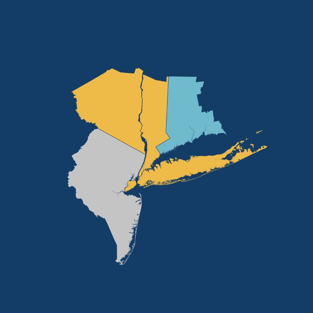
We’re excited to share “Zoning Report: Cape Cod,” our new publication offering insights into how zoning shapes Barnstable County!
www.zoningatlas.org/zoning-repor...
🧵
www.zoningatlas.org/zoning-repor...
🧵

July 28, 2025 at 5:15 PM
We’re excited to share “Zoning Report: Cape Cod,” our new publication offering insights into how zoning shapes Barnstable County!
www.zoningatlas.org/zoning-repor...
🧵
www.zoningatlas.org/zoning-repor...
🧵
📣 Calling all professors! Are you teaching about zoning, land use, or housing this semester? Consider adding the National Zoning Atlas to your syllabus!
Click here to learn more about our ready-to-use teaching module:
www.zoningatlas.org/teaching-mat...
Click here to learn more about our ready-to-use teaching module:
www.zoningatlas.org/teaching-mat...

National Zoning Atlas Teaching Materials — National Zoning Atlas
www.zoningatlas.org
July 24, 2025 at 7:29 PM
📣 Calling all professors! Are you teaching about zoning, land use, or housing this semester? Consider adding the National Zoning Atlas to your syllabus!
Click here to learn more about our ready-to-use teaching module:
www.zoningatlas.org/teaching-mat...
Click here to learn more about our ready-to-use teaching module:
www.zoningatlas.org/teaching-mat...