AerosolWatch
@aerosolwatch.bsky.social
300 followers 52 following 220 posts
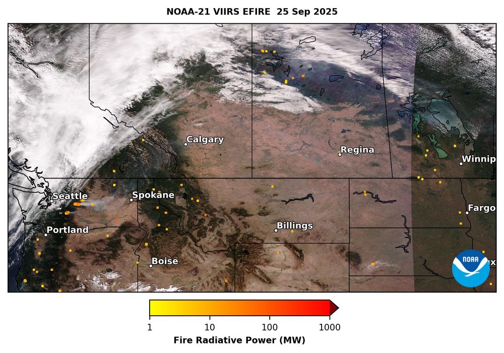
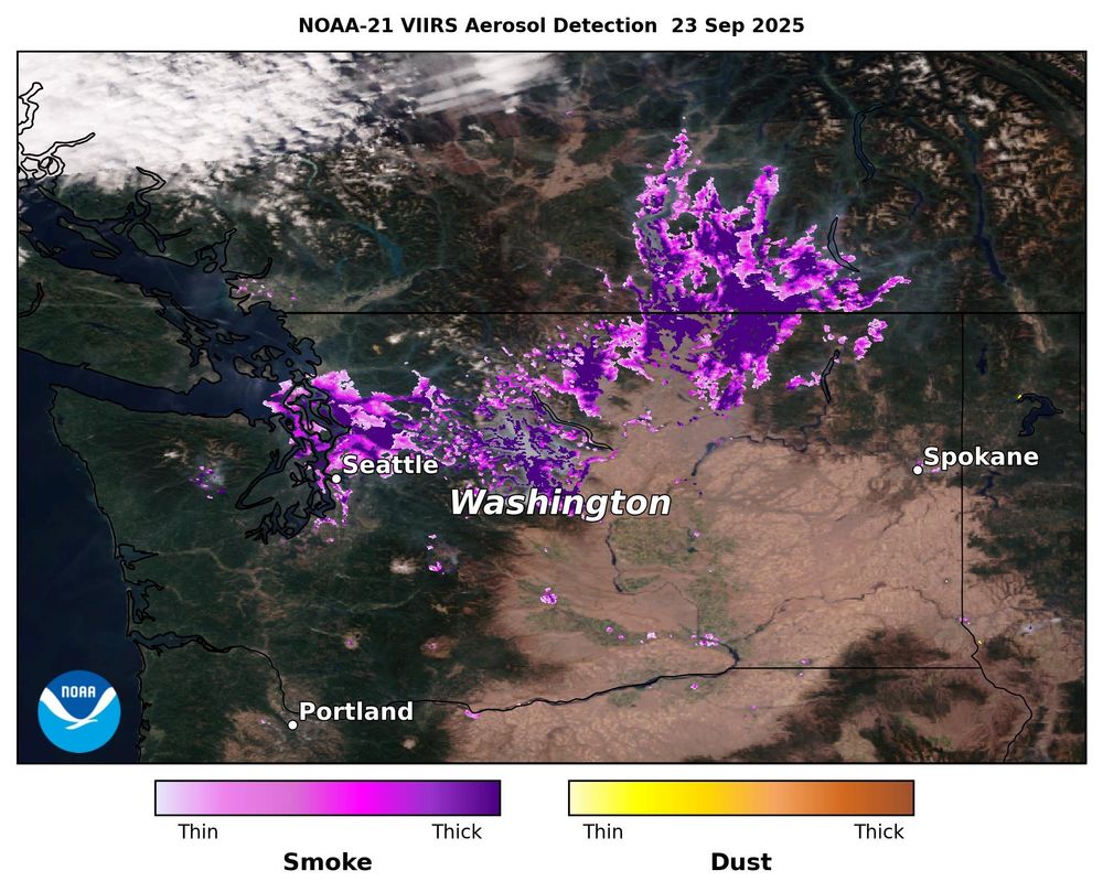
Satellite observations of global aerosol and air quality events, including wildfires, dust storms, and haze. Featuring NOAA satellite products from the AerosolWatch website (https://www.star.nesdis.noaa.gov/smcd/spb/aq/AerosolWatch/).
Posts Media Videos Starter Packs
aerosolwatch.bsky.social
Smoke from ongoing wildfires in the Pacific NW pushed daily-average PM2.5 air quality above the US health standard on 28 Sep in northern ID, southwestern OR & central-northern WA, per regulatory monitors & estimated by the VIIRS sensor on @noaa.gov satellites. @saramelinda.bsky.social
aerosolwatch.bsky.social
Many wildfires were still burning in the US Pacific Northwest & western Canada on 25 Sep, including relatively intense wildfires in Washington State, measured by fire radiative power (yellow/orange markers) from the VIIRS sensor on @noaa.gov NOAA-21. @mparrington.bsky.social @weatherwest.bsky.social
aerosolwatch.bsky.social
Smoke from ongoing wildfires in Washington State degraded PM2.5 air quality again on 24 Sep. Daily average conditions reached Very Unhealthy (Code Purple) in Leavenworth & Wenatchee, observed by regulatory monitors (dots) & estimated by @noaa.gov satellites (shading). @saramelinda.bsky.social
aerosolwatch.bsky.social
Thick smoke (purple shading) from wildfires in Washington State blew northward into British Columbia, Canada yesterday 23 Sep, observed by the VIIRS sensor on the @noaa.gov NOAA-21 satellite. @saramelinda.bsky.social @mparrington.bsky.social
aerosolwatch.bsky.social
The ABI sensor on the @noaa.gov GOES-West satellite is observing thick smoke from ongoing wildfires in Washington State today 23 Sep. The smoke is seriously degrading PM2.5 air quality per surface regulatory monitors (orange & purple dots).
aerosolwatch.bsky.social
Wildfires in northwestern Washington State and southern British Columbia emitted thick smoke (purple shading) that reached into western Alberta yesterday 17 Sep, detected by the VIIRS sensor on the NOAA-20 satellite. @noaa.gov @saramelinda.bsky.social @mparrington.bsky.social
aerosolwatch.bsky.social
The VIIRS sensor on the NOAA-21 satellite detected a plume of thick Saharan dust (brown shading) blowing off the coast of West Africa & over the Atlantic Ocean yesterday 16 Sep. @dustycryder.bsky.social @mparrington.bsky.social
aerosolwatch.bsky.social
Aerosol optical depth (AOD) from the ABI sensor on the @noaa.gov GOES-East satellite observed moderately thick to very thick wildfire smoke (AOD ≥0.6) in between clouds over the US Pacific Northwest & southern British Columbia, Canada on 10 Sep.
aerosolwatch.bsky.social
Another day of intense burning by California's Garnet Fire spread Hazardous (Code Maroon), Very Unhealthy (Code Purple) & Unhealthy (Code Red) daily PM2.5 air quality into western Nevada on 8 Sep, observed by regulatory monitors (dots) & estimated by @noaa.gov VIIRS (shading). @usfs.bsky.social
aerosolwatch.bsky.social
Thick smoke from the Garnet Fire in California’s Sierra National Forest caused Very Unhealthy (Code Purple) to Unhealthy (Code Red) daily PM2.5 air quality on 7 Sep, observed by regulatory monitors (dots) & estimated by VIIRS (shading). @usfs.bsky.social @calfire.bsky.social @noaa.gov
aerosolwatch.bsky.social
The VIIRS sensor on the @noaa.gov NOAA-21 satellite measured intense burning of the Garnet Fire in California’s Sierra National Forest on 7 Sep, shown by the orange markers (Fire Radiative Power). The wildfire’s thick smoke blew northeast into Nevada. @calfire.bsky.social @usfs.bsky.social
aerosolwatch.bsky.social
It did a great job with the smoke transport event last week!
aerosolwatch.bsky.social
Surface PM2.5 concentration for 13:00-13:59 UTC estimated from the TEMPO & ABI sensors (shading) & observed by regulatory monitors (dots) confirms the transported wildfire smoke over the eastern US this morning is not seriously impacting air quality. @avoiland.bsky.social @mparrington.bsky.social
aerosolwatch.bsky.social
The new @noaa.gov Aerosol Layer Height product from TEMPO indicates the thick wildfire smoke reaching the eastern US this morning is >2 km aloft in the atmosphere (maroon/purple/pink shading), and therefore having minimal impacts on surface air quality. @avoiland.bsky.social @mparrington.bsky.social
aerosolwatch.bsky.social
Yesterday’s thick, brown-colored smoke, originating from wildfires in the western US & Canada, has reached the eastern US this morning 5 Sep. Hybrid smoke detection from the TEMPO & ABI sensors shows the smoke (dark purple) as of ~13 UTC. @noaa.gov @avoiland.bsky.social @mparrington.bsky.social
aerosolwatch.bsky.social
The ABI sensor on the @noaa.gov GOES-East satellite is observing thick, brown-colored wildfire smoke moving southeastward over the Pacific Northwest and Central Plains of the US this afternoon 4 Sep, impacting hourly PM2.5 air quality (colored dots).
aerosolwatch.bsky.social
Thick smoke (red shading) from large wildfires in the US states of CA, ID, OR & WA, as well as in British Columbia, Canada, spread across parts of the western US yesterday 3 Sep, shown by aerosol optical depth from the VIIRS sensor on the @noaa.gov NOAA-21 satellite. @mparrington.bsky.social
aerosolwatch.bsky.social
The ABI sensor on the @noaa.gov GOES-East satellite is observing wildfire smoke degrading hourly PM2.5 air quality (colored dots) across the US Pacific NW & Upper Midwest this morning 3 Sep. @mparrington.bsky.social
aerosolwatch.bsky.social
Another episode of long-range wildfire smoke transport is underway. The VIIRS sensor on the @noaa.gov NOAA-20 satellite shows smoke (pink/purple) from fires in western Canada & US stretching across the continent to the Labrador Sea yesterday 1 Sep. @mparrington.bsky.social
aerosolwatch.bsky.social
Wildfires in the western US continued burning on 26 Aug, observed by @noaa.gov VIIRS on NOAA-20. Fire radiative power (FRP, Left) shows the fires' location & intensity, and aerosol detection (Right) indicates the fires released thick smoke (purple). @saramelinda.bsky.social @mparrington.bsky.social
aerosolwatch.bsky.social
Numerous wildfires in the Western US continued burning yesterday 25 Aug. UV Aerosol Index from the TEMPO satellite sensor “sees” smoke above clouds, highlighting plumes from fires in Oregon, Idaho & Wyoming (red, orange, yellow, green shading). @avoiland.bsky.social @saramelinda.bsky.social
aerosolwatch.bsky.social
Aerosol optical depth (AOD) from the VIIRS sensor on the @noaa.gov NOAA-21 satellite observed thick smoke (dark red shading, AOD ≥1) across the Western US on 23 Aug from numerous wildfires, particularly in Idaho, Montana & Wyoming. @saramelinda.bsky.social @sangasso.bsky.social
aerosolwatch.bsky.social
Smoke from the Island Creek wildfire in Idaho degraded daily PM2.5 air quality yesterday 21 Aug, with Unhealthy (Code Red) conditions near the fire & Moderate (Code Yellow) further downwind; observed by regulatory monitors (dots) & estimated from @noaa.gov VIIRS (shading). @saramelinda.bsky.social
aerosolwatch.bsky.social
Aerosol optical depth from the VIIRS sensor on the @noaa.gov NOAA-21 satellite observed smoke (red/orange/yellow/teal shading, AOD ≥0.5) across the Iberian Peninsula today 21 Aug from the ongoing wildfires in Portugal & Spain. @mparrington.bsky.social @pierremarkuse.bsky.social @aprados1.bsky.social