


@benoitlalonde.bsky.social
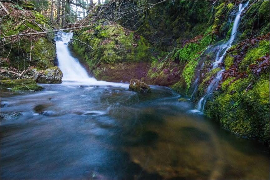
Waterfall Wednesday. I explored the upper gorge of the Barachois in Cape Breton Island for some waterfalls and I wasn’t disappointed. Sure you have to bushwhack to get there and that road leading close to the river is an adventure in itself but the rewards are pure awesomeness.


July 16, 2025 at 11:43 AM
Waterfall Wednesday. I explored the upper gorge of the Barachois in Cape Breton Island for some waterfalls and I wasn’t disappointed. Sure you have to bushwhack to get there and that road leading close to the river is an adventure in itself but the rewards are pure awesomeness.
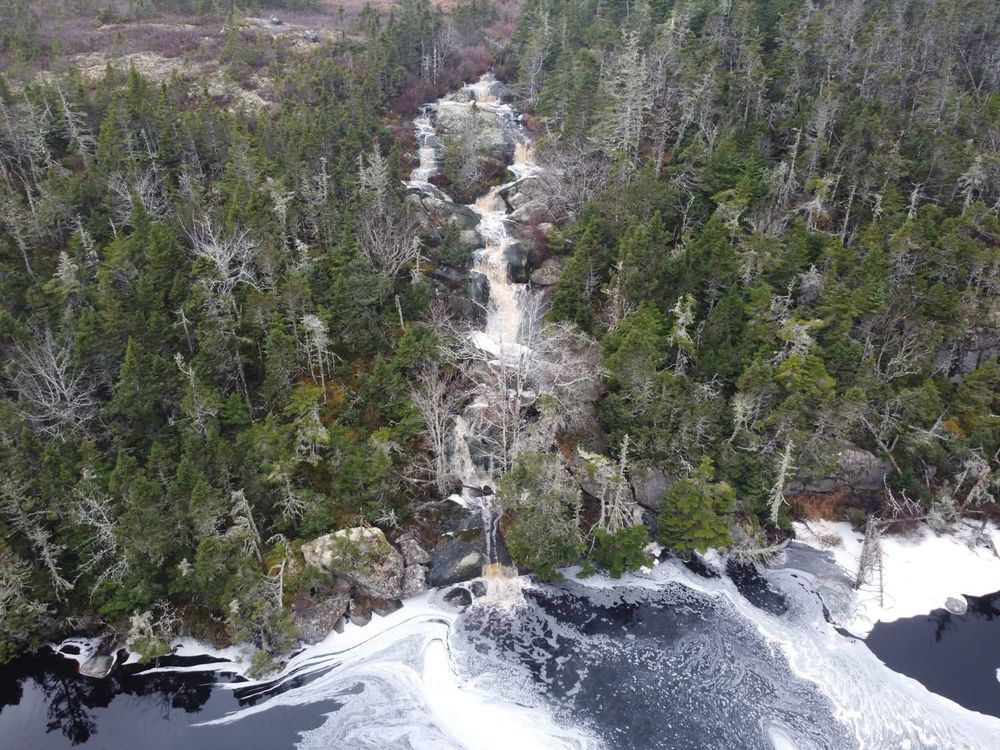
The choice… hike about 6km with 1000 fr elevation lost to get to the “Eye of the Needle” in the Walton Glen Gorge in New Brunswick or watch this short clip! Better yet.. do both!
July 1, 2025 at 12:01 AM
The choice… hike about 6km with 1000 fr elevation lost to get to the “Eye of the Needle” in the Walton Glen Gorge in New Brunswick or watch this short clip! Better yet.. do both!
Back in early March, I was reading an old except from the 1890's on a geological survey. They mentioned a cave. The power of LIDAR made me choose an area (see attached with arrow) that would be perfect for the stream to carve out that "cave" described in the report. I was right!


May 9, 2025 at 5:43 PM
Back in early March, I was reading an old except from the 1890's on a geological survey. They mentioned a cave. The power of LIDAR made me choose an area (see attached with arrow) that would be perfect for the stream to carve out that "cave" described in the report. I was right!
The last and best video on discovering a pretty much under explored cave near Falmouth. I’ve explored a lot for caves both by researching old archives and also by bushwhacking and had never come across any information about this one!
April 28, 2025 at 11:45 PM
The last and best video on discovering a pretty much under explored cave near Falmouth. I’ve explored a lot for caves both by researching old archives and also by bushwhacking and had never come across any information about this one!
If you know me at all, you know that I never stop exploring! In a day where I hit 5 under explored karst areas of the Stewiacke Valley, I actually found a brand new cave system. Finding caves is a lot harder than finding waterfalls so this is a rare event!
March 16, 2025 at 10:29 PM
If you know me at all, you know that I never stop exploring! In a day where I hit 5 under explored karst areas of the Stewiacke Valley, I actually found a brand new cave system. Finding caves is a lot harder than finding waterfalls so this is a rare event!
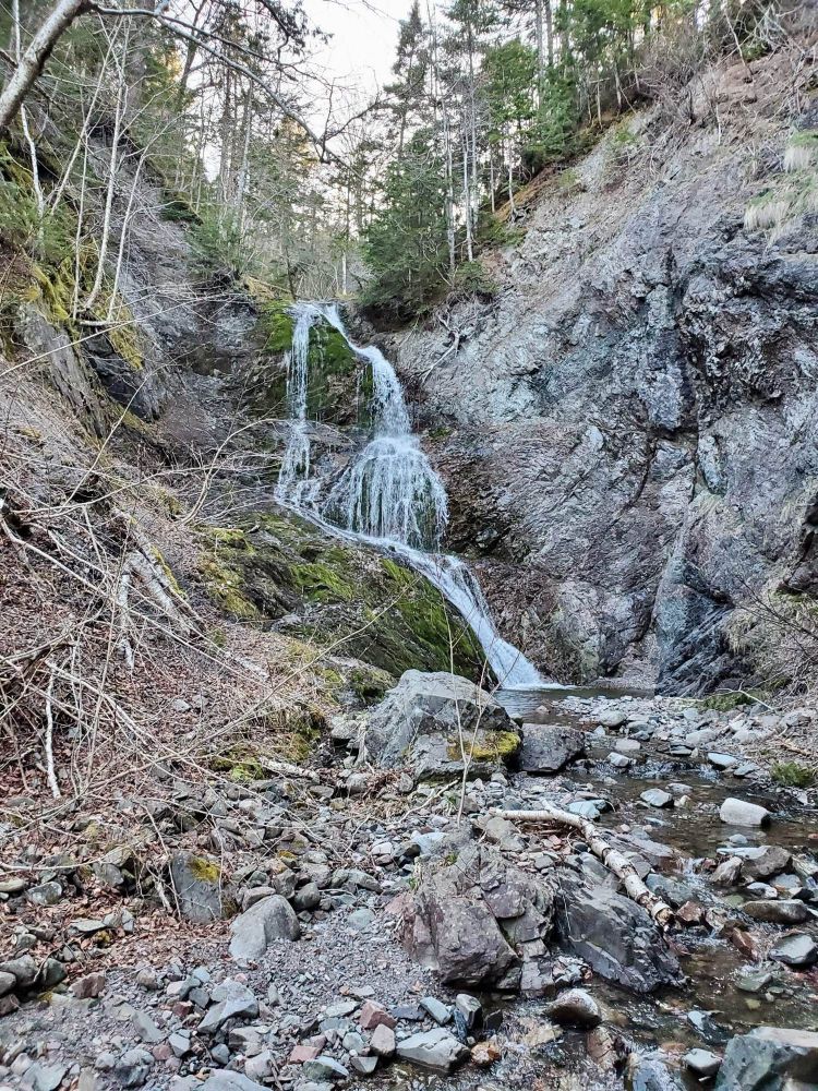
Perfect conditions at Butcher Hill Fall, Nova Scotia

March 14, 2025 at 10:25 PM
Perfect conditions at Butcher Hill Fall, Nova Scotia
Day 26/26 Z is for Zeke Brook Fall (N44.97116° W64.84956°), Annapolis Valley

March 9, 2025 at 3:19 AM
Day 26/26 Z is for Zeke Brook Fall (N44.97116° W64.84956°), Annapolis Valley
Day 25/26 Y is for Yankee Line Fall near Nyanza (46.1324672486292, -60.91641233320721) , Cape Breton Island and York Settlement fall (N45.44769° W64.44817°) near Parrsboro
March 7, 2025 at 11:44 PM
Day 25/26 Y is for Yankee Line Fall near Nyanza (46.1324672486292, -60.91641233320721) , Cape Breton Island and York Settlement fall (N45.44769° W64.44817°) near Parrsboro
Weekend inspiration time. Great time to explore barrens like this one a few minutes outside HRM. Lots of bouldering opportunities! trailpeak.com/trails/13907


March 7, 2025 at 12:23 PM
Weekend inspiration time. Great time to explore barrens like this one a few minutes outside HRM. Lots of bouldering opportunities! trailpeak.com/trails/13907
Day 22/26 V is for Village Brook Fall near Londonderry (45.50115043047748, -63.62321190754201) and Valley Mill Fall (N45.84418° W61.10382°) in Cape Breton Island.


March 5, 2025 at 12:40 AM
Day 22/26 V is for Village Brook Fall near Londonderry (45.50115043047748, -63.62321190754201) and Valley Mill Fall (N45.84418° W61.10382°) in Cape Breton Island.
Day 21/26 U is for Upper Lake Fall (N45.26216° W61.05781°) near Dover and Urquhart Fall (N46.47080° W60.47105°) , North Shore Cape Breton.(picture on left)

March 3, 2025 at 11:24 PM
Day 21/26 U is for Upper Lake Fall (N45.26216° W61.05781°) near Dover and Urquhart Fall (N46.47080° W60.47105°) , North Shore Cape Breton.(picture on left)
Day 20/26 T is for Timber Brook Fall (N46.34409° W60.64991°) in Cape Breton and Three Ponds Fall (N45.33968° W61.60263°) in Guysborough Co.


March 3, 2025 at 12:10 AM
Day 20/26 T is for Timber Brook Fall (N46.34409° W60.64991°) in Cape Breton and Three Ponds Fall (N45.33968° W61.60263°) in Guysborough Co.
Day 19/26. S is for Slaty Brook fall (N44.95236° W63.60425°) near Grand Lake and Shunacadie fall (N46.00386° W60.65837°) Cape Breton Island.


March 2, 2025 at 1:14 AM
Day 19/26. S is for Slaty Brook fall (N44.95236° W63.60425°) near Grand Lake and Shunacadie fall (N46.00386° W60.65837°) Cape Breton Island.
Day 18/26 R is for Red River Gorge Fall (N46.83195° W60.67426°) in Cape Breton and Rhodenizer Brook fall (N44.37696° W64.47756°) in Bridgewater


March 1, 2025 at 2:05 AM
Day 18/26 R is for Red River Gorge Fall (N46.83195° W60.67426°) in Cape Breton and Rhodenizer Brook fall (N44.37696° W64.47756°) in Bridgewater
Day 17/26. Q is for Quarry Lake fall in Terence Bay (N44.48612° W63.71811°) and one that I haven’t explored yet but have a strong hunch is Quarry Brook in St Anns Bay (N46.25468° W60.65206°), Cape Breton Island. Happy exploring!

February 27, 2025 at 11:14 PM
Day 17/26. Q is for Quarry Lake fall in Terence Bay (N44.48612° W63.71811°) and one that I haven’t explored yet but have a strong hunch is Quarry Brook in St Anns Bay (N46.25468° W60.65206°), Cape Breton Island. Happy exploring!
Day 16/26. P is for Princeville fall (N45.76381° W61.28350°) in Cape Breton and Porcupine fall (N45.23305° W64.50219°) in Baxters Harbour


February 26, 2025 at 11:20 PM
Day 16/26. P is for Princeville fall (N45.76381° W61.28350°) in Cape Breton and Porcupine fall (N45.23305° W64.50219°) in Baxters Harbour
Day 15/ 26. O is for O’Toole Brook Fall (N45.12328° W63.64946°) near Gore and O’Law fall (N46.28843° W60.94830°) in a remote valley off Lake O’Law in Cape Breton.


February 25, 2025 at 11:48 PM
Day 15/ 26. O is for O’Toole Brook Fall (N45.12328° W63.64946°) near Gore and O’Law fall (N46.28843° W60.94830°) in a remote valley off Lake O’Law in Cape Breton.
Day 13/26. M is for McEvoy Barren fall in Cape Breton (46.9081972633212, -60.583041668177465) and Melford Fall near the Canso causeway (45.52481923084371, -61.31153842118779).


February 24, 2025 at 12:14 AM
Day 13/26. M is for McEvoy Barren fall in Cape Breton (46.9081972633212, -60.583041668177465) and Melford Fall near the Canso causeway (45.52481923084371, -61.31153842118779).
Day 12/26 L is for Leblanc Brook fall in Cape Breton Island (N46.63179° W60.84180°) and Little River fall in the Gaspereau Valley


February 23, 2025 at 12:49 AM
Day 12/26 L is for Leblanc Brook fall in Cape Breton Island (N46.63179° W60.84180°) and Little River fall in the Gaspereau Valley
Day 11/26 K is for Kavanaugh Brook (aka Beauvais Lake Fall) fall (N45.63834° W60.84533°) near St Peters Cape Breton Island and Kearney Lake Dam fall in Halifax (44.70490, -63.70245343)


February 22, 2025 at 12:33 PM
Day 11/26 K is for Kavanaugh Brook (aka Beauvais Lake Fall) fall (N45.63834° W60.84533°) near St Peters Cape Breton Island and Kearney Lake Dam fall in Halifax (44.70490, -63.70245343)
Weekend inspiration. Details to explore the Sibley skate quarry near Coldstream. trailpeak.com/trails/13908


February 21, 2025 at 10:59 AM
Weekend inspiration. Details to explore the Sibley skate quarry near Coldstream. trailpeak.com/trails/13908
Day 10/26 and J is for Jeffers Brook fall just north of Parrsboro (home of Ripley's Fall) (45.46989609255149, -64.30980575796339) and Jersey Cove fall in Cape Breton Island (46.309239642176216, -60.553020228600936)

February 21, 2025 at 12:11 AM
Day 10/26 and J is for Jeffers Brook fall just north of Parrsboro (home of Ripley's Fall) (45.46989609255149, -64.30980575796339) and Jersey Cove fall in Cape Breton Island (46.309239642176216, -60.553020228600936)
Day 9/26 and I stands for Ingonish River tributary Fall (46.612681155548145, -60.4600804211649) and Indian Fall in Newburne (44.591256244935664, -64.60480443368925)


February 19, 2025 at 11:25 PM
Day 9/26 and I stands for Ingonish River tributary Fall (46.612681155548145, -60.4600804211649) and Indian Fall in Newburne (44.591256244935664, -64.60480443368925)
Day 5/26 and E stands for Effies Brook Fall (46.85746092628985, -60.46920968234211) in Cape Breton and East Branch Moose River fall (tallest on the mainland// 45.441196404667714, -64.1766682961844) near Parrsboro


February 15, 2025 at 6:06 PM
Day 5/26 and E stands for Effies Brook Fall (46.85746092628985, -60.46920968234211) in Cape Breton and East Branch Moose River fall (tallest on the mainland// 45.441196404667714, -64.1766682961844) near Parrsboro
Weekend inspiration. Vastly under explored Bouldering area right next to Halifax. Details here: trailpeak.com/trails/13909


February 14, 2025 at 2:23 PM
Weekend inspiration. Vastly under explored Bouldering area right next to Halifax. Details here: trailpeak.com/trails/13909