Andrew Sanchez Meador
@bi0m3trics.bsky.social
46 followers 30 following 14 posts
Exec. Director at eri.nau.edu | Prof. at nau.edu/forestry | Forest restoration, biometrics, AI & lidar | Land Cruiser 80 Series enthusiast | Passionate about impactful science & strategic leadership | quantitativeecology.org | Views my own
Posts Media Videos Starter Packs
Pinned
bi0m3trics.bsky.social
Just out: A new geodatabase of fuel treatments across federal lands—published in Scientific Data.

Whether you’re mapping change or assessing risk, TWIG shows when and where treatments happened.

Grateful to be part of a team!

Paper - www.nature.com/articles/s41...
TWIG - reshapewildfire.org/twig
bi0m3trics.bsky.social
From data gaps to actionable insight — TWIG tracks wildfire treatments coast to coast.
news.nau.edu/twig/
https://news.nau.edu/twig/
bi0m3trics.bsky.social
I just grabbed the tiles that overlapped NAU property... plus I don't want to see how high the solar potential is in my back yards now that my neighbor to the west removed like 6 trees!
bi0m3trics.bsky.social
Quick little run last night on a 37sq km area in Flagstaff using vostokR (my R wrapper for VOSTOK - doi.org/10.11588/dat...). I've got most* of the kinks worked, made it 2.5x faster, and it now works with lidR!!!! It's almost ready for release.
VOSTOK - The Voxel Octree Solar Toolkit
VOSTOK is a command-line tool to compute a detailed model of incoming solar radiation distribution on a patch of land, including structures like bu...
doi.org
bi0m3trics.bsky.social
Looking for some shade on NAU's campus or in downtown Flagstaff? I got you covered...
bi0m3trics.bsky.social
Just out: A new geodatabase of fuel treatments across federal lands—published in Scientific Data.

Whether you’re mapping change or assessing risk, TWIG shows when and where treatments happened.

Grateful to be part of a team!

Paper - www.nature.com/articles/s41...
TWIG - reshapewildfire.org/twig
Reposted by Andrew Sanchez Meador
firescar.bsky.social
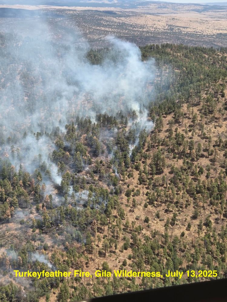
The Turkeyfeather Fire in the Gila Wilderness, NM has burned as a low-severity fire over about 24,000 acres (so far). This is a continuation of a fire regime that existed for millennia before the 20th century. This 🧵reviews the fire history of the Gila, as my colleagues and I have studied it. 1/18
low severity surface fire burning through a ponderosa pine forest
Reposted by Andrew Sanchez Meador
jefferybcannon.bsky.social
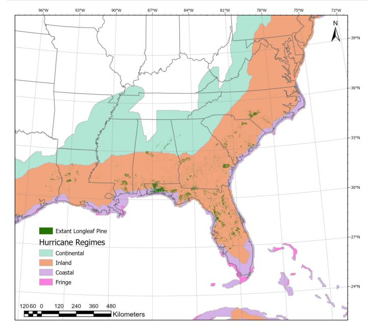
🔥 New study: 85% of remaining #LongleafPine habitat faces tropical storm-force winds every 6 years. We explore how #storms, #fire, insects, and salvage logging interact to shape resilience—and what managers can do about it. bit.ly/44QK3Uk Led by @nzampieri.bsky.social
bi0m3trics.bsky.social
Handheld lidar sensors can accurately measure aboveground biomass - Atkins - 2025 - Ecosphere - Wiley Online Library esajournals.onlinelibrary.wiley.com/doi/10.1002/...

Happy to see this one out too!
bi0m3trics.bsky.social
Got to get out and do a little PJ scanning today.
bi0m3trics.bsky.social
Implemented a solution for a MS student's project, so when I find time to get back to it I'll likely try and get it packaged.
bi0m3trics.bsky.social
Finally got the first version of my R code/wrapper working that calculates solar potential in watt hours per square meter and day, summed by pixel using vostok - github.com/3dgeo-heidel...
bi0m3trics.bsky.social
The allusive search for "age" from lidar continues....
bi0m3trics.bsky.social
Spent the morning prepping some visuals using #lidR ands #spanner - github.com/bi0m3trics/s...