


The Cartography and Geographic Information Society
@carto-giscience.bsky.social
The Cartography and Geographic Information Society supports research, education, and practice to improve the understanding, creation, analysis, and use of maps and geographic information to support effective decision-making and improve the quality of life.
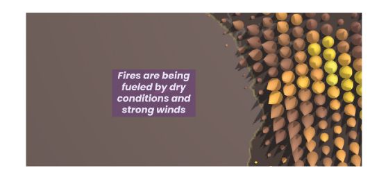
New article! Using storytelling and guided interactions to help users understand large spatial and temporal data sets. Oana Candit et al. provide an example representing active fires of 2023 Paper: doi.org/10.1080/1523... App: www.animation.oanacanditmaps.ro/app/ #GISchat
December 8, 2025 at 4:30 PM
New article! Using storytelling and guided interactions to help users understand large spatial and temporal data sets. Oana Candit et al. provide an example representing active fires of 2023 Paper: doi.org/10.1080/1523... App: www.animation.oanacanditmaps.ro/app/ #GISchat
New paper! Thomas Depian et al. investigate transitions in dynamic point labelling which are an issue in dynamic mapping systems. Weather data in Vienna - the labels change and it is not obvious which have changed doi.org/10.1080/1523... #GISchat #OpenAccess doi.org/10.17605/OSF...

December 3, 2025 at 3:59 PM
New paper! Thomas Depian et al. investigate transitions in dynamic point labelling which are an issue in dynamic mapping systems. Weather data in Vienna - the labels change and it is not obvious which have changed doi.org/10.1080/1523... #GISchat #OpenAccess doi.org/10.17605/OSF...
New article! Timofey Samsonov explores animated transitions proportional symbol and choropleth representations on thematic maps #GISchat #ICC2023 doi.org/10.1080/1523... Check out the supplementary videos of each transition at zenodo.org/records/1717... and see it in practice at observablehq.com

December 2, 2025 at 11:57 AM
New article! Timofey Samsonov explores animated transitions proportional symbol and choropleth representations on thematic maps #GISchat #ICC2023 doi.org/10.1080/1523... Check out the supplementary videos of each transition at zenodo.org/records/1717... and see it in practice at observablehq.com
We all know color in maps is important. Shangjing Jiang and colleagues used crowdsourced photographs to create place-aware colored maps which help create a sense of place doi.org/10.1080/1523... #GISchat Figure 1 below shows their comparisons: Google Maps, Snazzy Maps "Hopper" and place-aware maps

December 1, 2025 at 11:51 AM
We all know color in maps is important. Shangjing Jiang and colleagues used crowdsourced photographs to create place-aware colored maps which help create a sense of place doi.org/10.1080/1523... #GISchat Figure 1 below shows their comparisons: Google Maps, Snazzy Maps "Hopper" and place-aware maps
At a festival with events happening over a week and over a whole city? Dilara Bozkurt explores temporal navigation for festival maps on mobile devices, working out how to incorporate space and time on a small screen like a mobile phone doi.org/10.1080/1523... #GISchat #OpenAccess Check out the GIF:
November 27, 2025 at 3:02 PM
At a festival with events happening over a week and over a whole city? Dilara Bozkurt explores temporal navigation for festival maps on mobile devices, working out how to incorporate space and time on a small screen like a mobile phone doi.org/10.1080/1523... #GISchat #OpenAccess Check out the GIF:
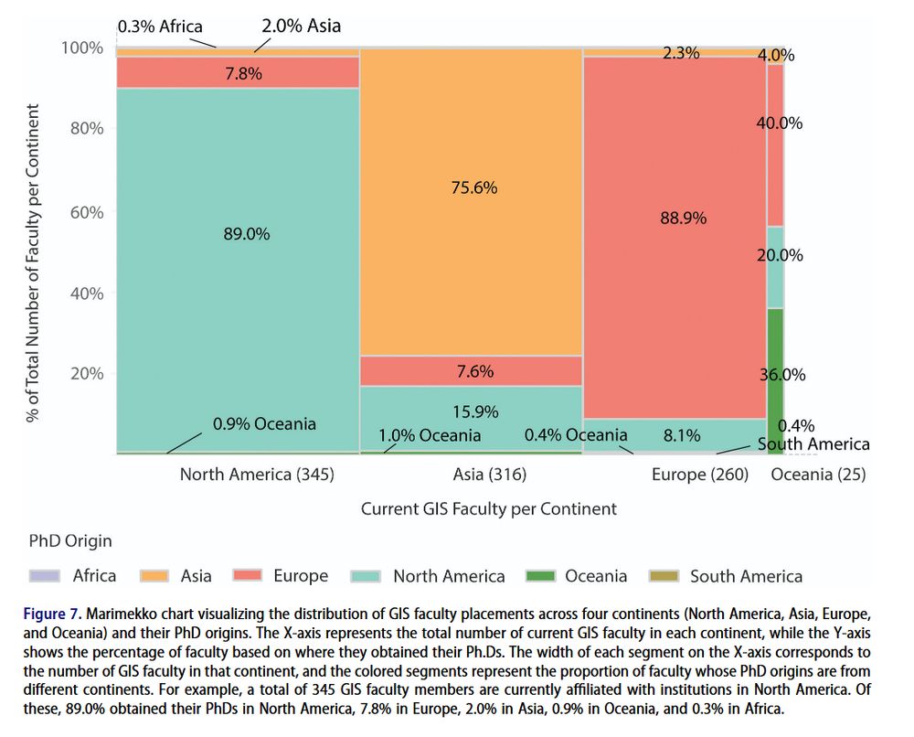
New article! Where are GIScience faculty hired from? Yanbing Chen and colleagues, using data from GISphere, analyze faculty mobility and research themes through hiring networks #GISchat doi.org/10.1080/1523... Below: where current GIS faculty are (x-axis) and where they got their PhDs (y-axis).
November 25, 2025 at 11:55 AM
New article! Where are GIScience faculty hired from? Yanbing Chen and colleagues, using data from GISphere, analyze faculty mobility and research themes through hiring networks #GISchat doi.org/10.1080/1523... Below: where current GIS faculty are (x-axis) and where they got their PhDs (y-axis).
Fantastic article on Georeferencing historical maps using automated processes, including local feature matching and Delaunay consistency from Beatrice Vaienti, Isabella di Lenardo and Frédéric Kaplan doi.org/10.1080/1523... #GISchat #OpenAccess


November 24, 2025 at 4:50 PM
Fantastic article on Georeferencing historical maps using automated processes, including local feature matching and Delaunay consistency from Beatrice Vaienti, Isabella di Lenardo and Frédéric Kaplan doi.org/10.1080/1523... #GISchat #OpenAccess
New paper from Hong Wang, Mingda Zhang and colleagues: Evaluating color preference in thematic maps, a case study from China doi.org/10.1080/1523... #GISchat See below, figure 12: The true and predicted values of a selection of maps, with higher values for better maps.

November 20, 2025 at 3:13 PM
New paper from Hong Wang, Mingda Zhang and colleagues: Evaluating color preference in thematic maps, a case study from China doi.org/10.1080/1523... #GISchat See below, figure 12: The true and predicted values of a selection of maps, with higher values for better maps.
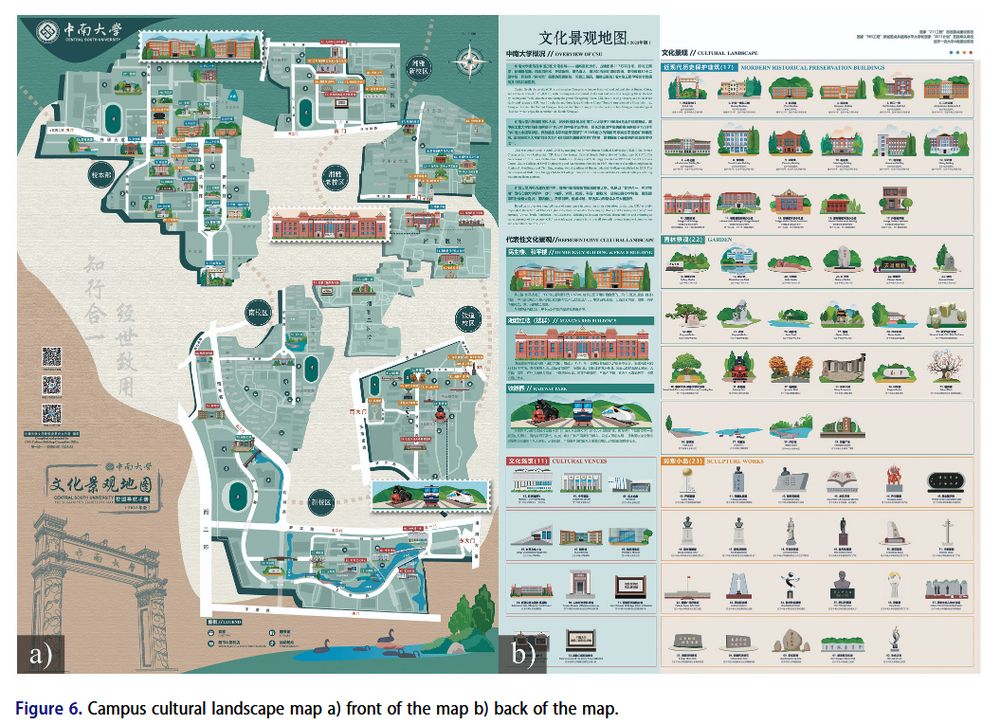
How to design a campus cultural landscape map? Tao Zou and colleagues designed a map and then explored the user experience of the map doi.org/10.1080/1523... #GISchat Check out their map below, and the full res version at figshare.com/articles/dat...
November 19, 2025 at 4:37 PM
How to design a campus cultural landscape map? Tao Zou and colleagues designed a map and then explored the user experience of the map doi.org/10.1080/1523... #GISchat Check out their map below, and the full res version at figshare.com/articles/dat...
Deepfake geography: A new paper from Valentin Meo looking at how we can detect manipulated satellite images doi.org/10.1080/1523... Also check out our interview on the paper with Valentin and @nickbearman.bsky.social: youtu.be/DklnevrHR1c #GISchat #FreeAccess

November 17, 2025 at 2:30 PM
Deepfake geography: A new paper from Valentin Meo looking at how we can detect manipulated satellite images doi.org/10.1080/1523... Also check out our interview on the paper with Valentin and @nickbearman.bsky.social: youtu.be/DklnevrHR1c #GISchat #FreeAccess
Lastly, Eric Delmelle is stepping down as Editor-in-Chief with Angela Yao stepping up to take his place - thank you Eric and Angela. And finally, thank you to our amazing 215 reviewers who help us make the journal what it is. doi.org/10.1080/1523...

November 12, 2025 at 11:07 AM
Lastly, Eric Delmelle is stepping down as Editor-in-Chief with Angela Yao stepping up to take his place - thank you Eric and Angela. And finally, thank you to our amazing 215 reviewers who help us make the journal what it is. doi.org/10.1080/1523...
Fantastic new article looking at whether schematic maps (e.g. the London Tube map) can help with pedestrian route planning, from Ruyu Dai and colleagues, #GISchat doi.org/10.1080/1523...
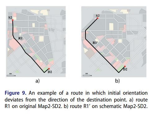
November 12, 2025 at 11:05 AM
Fantastic new article looking at whether schematic maps (e.g. the London Tube map) can help with pedestrian route planning, from Ruyu Dai and colleagues, #GISchat doi.org/10.1080/1523...
Taisheng Chen, Kun Hu et al. present a new way to automatically enhance qualitative color schemes for color vision deficiency, doi.org/10.1080/1523... #GISchat

November 12, 2025 at 11:04 AM
Taisheng Chen, Kun Hu et al. present a new way to automatically enhance qualitative color schemes for color vision deficiency, doi.org/10.1080/1523... #GISchat
Great new article from Julian Keil and colleagues, looking at the landmark attraction effect, where locations are memorized closer to prominent landmarks than they actually are. The symbol used also has an impact on this. doi.org/10.1080/1523... #GISchat #OpenAccess

November 12, 2025 at 11:04 AM
Great new article from Julian Keil and colleagues, looking at the landmark attraction effect, where locations are memorized closer to prominent landmarks than they actually are. The symbol used also has an impact on this. doi.org/10.1080/1523... #GISchat #OpenAccess
Issue 52-6 of Cartography and Geographic Information Science is now available!
We have 8 papers, inc. navigation, symbology, schematic representations of roads maps, labelling, Swiss style relief shading maps and a thank you to our reviewers!
www.tandfonline.com/toc/tcag20/5... #GISchat
We have 8 papers, inc. navigation, symbology, schematic representations of roads maps, labelling, Swiss style relief shading maps and a thank you to our reviewers!
www.tandfonline.com/toc/tcag20/5... #GISchat

November 12, 2025 at 11:03 AM
Issue 52-6 of Cartography and Geographic Information Science is now available!
We have 8 papers, inc. navigation, symbology, schematic representations of roads maps, labelling, Swiss style relief shading maps and a thank you to our reviewers!
www.tandfonline.com/toc/tcag20/5... #GISchat
We have 8 papers, inc. navigation, symbology, schematic representations of roads maps, labelling, Swiss style relief shading maps and a thank you to our reviewers!
www.tandfonline.com/toc/tcag20/5... #GISchat
New article! Darlan Miranda Nunes & Silvana Philippi Camboim investigate Collaborative toponyms in OpenStreetMap evaluating the potential to complement and update National Mapping Agencies data, doi.org/10.1080/1523... also see their code and process at github.com/darlanmnunes...
#GISchat
#GISchat

November 5, 2025 at 3:03 PM
New article! Darlan Miranda Nunes & Silvana Philippi Camboim investigate Collaborative toponyms in OpenStreetMap evaluating the potential to complement and update National Mapping Agencies data, doi.org/10.1080/1523... also see their code and process at github.com/darlanmnunes...
#GISchat
#GISchat
New paper! Fascinating discussion of Optimizing electric vehicle supply equipment allocation using a range of local and global MCDA methods by Emily Zhou & Junyi Yang, #GISchat doi.org/10.1080/1523...

November 4, 2025 at 3:06 PM
New paper! Fascinating discussion of Optimizing electric vehicle supply equipment allocation using a range of local and global MCDA methods by Emily Zhou & Junyi Yang, #GISchat doi.org/10.1080/1523...
Fantastic new article from Lars De Sloover and colleagues from Department of Ggeography Ugent comparing impacts of Euclidean distance and dynamic time warping with spatiotemporal analysis of COVID-19 dynamics across Europe #GISchat doi.org/10.1080/1523...


October 16, 2025 at 4:33 PM
Fantastic new article from Lars De Sloover and colleagues from Department of Ggeography Ugent comparing impacts of Euclidean distance and dynamic time warping with spatiotemporal analysis of COVID-19 dynamics across Europe #GISchat doi.org/10.1080/1523...
New article! A fantastic new tool Exploropleth: exploratory analysis of data binning methods in choropleth maps, from @arpitnarechania.bsky.social Alex Endert & Clio Andris doi.org/10.1080/1523... #GISchat website exploropleth.github.io video of the tool in action: www.youtube.com/watch?v=lNV8...

October 13, 2025 at 4:08 PM
New article! A fantastic new tool Exploropleth: exploratory analysis of data binning methods in choropleth maps, from @arpitnarechania.bsky.social Alex Endert & Clio Andris doi.org/10.1080/1523... #GISchat website exploropleth.github.io video of the tool in action: www.youtube.com/watch?v=lNV8...
Great new article! Victor Irekponor & Taylor M. Oshan
address reproducibility in spatially varying coefficient (SVC) models, and introduce svc-viz, a open source Python tool to-do this #GISchat doi.org/10.1080/1523... github.com/marquisvicto...
address reproducibility in spatially varying coefficient (SVC) models, and introduce svc-viz, a open source Python tool to-do this #GISchat doi.org/10.1080/1523... github.com/marquisvicto...

October 9, 2025 at 2:36 PM
Great new article! Victor Irekponor & Taylor M. Oshan
address reproducibility in spatially varying coefficient (SVC) models, and introduce svc-viz, a open source Python tool to-do this #GISchat doi.org/10.1080/1523... github.com/marquisvicto...
address reproducibility in spatially varying coefficient (SVC) models, and introduce svc-viz, a open source Python tool to-do this #GISchat doi.org/10.1080/1523... github.com/marquisvicto...
New article! Fascinating new method of reconstructing maritime route networks for nearshore waters, using step-by-step density-based clustering from Jiale Pan and colleagues doi.org/10.1080/1523...

October 8, 2025 at 2:49 PM
New article! Fascinating new method of reconstructing maritime route networks for nearshore waters, using step-by-step density-based clustering from Jiale Pan and colleagues doi.org/10.1080/1523...
Great new article from Michala A. Garrison, Schyler A. Reis, Shiyu Zhang and Carolyn S. Fish, evaluating “narrative transportation” – how engrossed one becomes in a story when used in storytelling maps, and the impact of including maps and photos doi.org/10.1080/1523... #GISchat

September 29, 2025 at 3:28 PM
Great new article from Michala A. Garrison, Schyler A. Reis, Shiyu Zhang and Carolyn S. Fish, evaluating “narrative transportation” – how engrossed one becomes in a story when used in storytelling maps, and the impact of including maps and photos doi.org/10.1080/1523... #GISchat
New paper from Yunfei Ma, Yuan Zhang and colleagues, Where is Huaqiangbei? looking at how Huaqiangbei, one of Shenzhen’s largest business districts, has evolved over time doi.org/10.1080/1523...
#GISchat
#GISchat

September 29, 2025 at 1:45 PM
New paper from Yunfei Ma, Yuan Zhang and colleagues, Where is Huaqiangbei? looking at how Huaqiangbei, one of Shenzhen’s largest business districts, has evolved over time doi.org/10.1080/1523...
#GISchat
#GISchat
New paper! Marjan Ghanbari, Mohammad Karimi and colleagues analyse intra-city function regions using spatial analysis interaction, using a case study of Chicago, doi.org/10.1080/1523... #GISchat

September 24, 2025 at 2:10 PM
New paper! Marjan Ghanbari, Mohammad Karimi and colleagues analyse intra-city function regions using spatial analysis interaction, using a case study of Chicago, doi.org/10.1080/1523... #GISchat
New Paper! Yuanfang Chen and colleagues present a new way of contact-tracing, the PSTP-STRA method doi.org/10.1080/1523... #GISchat

September 18, 2025 at 2:05 PM
New Paper! Yuanfang Chen and colleagues present a new way of contact-tracing, the PSTP-STRA method doi.org/10.1080/1523... #GISchat