


Chris Nabholz
@chris-nabholz.bsky.social
Engineer and meteorologist. Alumni of Auburn, NC State, and Mississippi State Universities. US Navy veteran.
Lows have trended lower for Tuesday morning! Also, an update on the severe risk for today: dswx.substack.com/p/weekend-we...


November 7, 2025 at 2:48 PM
Lows have trended lower for Tuesday morning! Also, an update on the severe risk for today: dswx.substack.com/p/weekend-we...
Severe weather is possible for parts of the region on Friday and then a hard freeze Tuesday morning and maybe a little snow: dswx.substack.com/p/active-pat...


November 5, 2025 at 3:19 PM
Severe weather is possible for parts of the region on Friday and then a hard freeze Tuesday morning and maybe a little snow: dswx.substack.com/p/active-pat...
Some showers will be possible across the Southeast today through early Monday as another weather system moves through. Some areas won’t see a drop. This will also reinforce the cool air through the end of the week with maybe a brief warmup (and rain?) for next weekend.
November 1, 2025 at 4:57 PM
Some showers will be possible across the Southeast today through early Monday as another weather system moves through. Some areas won’t see a drop. This will also reinforce the cool air through the end of the week with maybe a brief warmup (and rain?) for next weekend.
Melissa, now a category 2 hurricane, moves off the coast of Cuba this morning with its sights set on the Eastern Bahamas while a cyclone of a different sort digs into the Southeast.
October 29, 2025 at 1:47 PM
Melissa, now a category 2 hurricane, moves off the coast of Cuba this morning with its sights set on the Eastern Bahamas while a cyclone of a different sort digs into the Southeast.
1/2 Looking back to the Southeast, we’re getting into a more active period. A low pressure system and cold front will dig south from the Middle MS Valley tonight bringing rain through Thursday. The highest rainfall amounts will be across TN and northern MS and AL,
October 29, 2025 at 12:02 AM
1/2 Looking back to the Southeast, we’re getting into a more active period. A low pressure system and cold front will dig south from the Middle MS Valley tonight bringing rain through Thursday. The highest rainfall amounts will be across TN and northern MS and AL,
Melissa is still a very powerful category 4 hurricane with 145 mph winds. Cuba is next along its path, with landfall expected before dawn tomorrow.

October 28, 2025 at 11:38 PM
Melissa is still a very powerful category 4 hurricane with 145 mph winds. Cuba is next along its path, with landfall expected before dawn tomorrow.
1/2 100 PM EDT Tue Oct 28 2025
...CATEGORY 5 MELISSA MAKES LANDFALL IN JAMAICA...
...ONE OF THE MOST POWERFUL HURRICANE LANDFALLS ON RECORD IN THE
ATLANTIC BASIN...
...CATEGORY 5 MELISSA MAKES LANDFALL IN JAMAICA...
...ONE OF THE MOST POWERFUL HURRICANE LANDFALLS ON RECORD IN THE
ATLANTIC BASIN...
October 28, 2025 at 5:12 PM
1/2 100 PM EDT Tue Oct 28 2025
...CATEGORY 5 MELISSA MAKES LANDFALL IN JAMAICA...
...ONE OF THE MOST POWERFUL HURRICANE LANDFALLS ON RECORD IN THE
ATLANTIC BASIN...
...CATEGORY 5 MELISSA MAKES LANDFALL IN JAMAICA...
...ONE OF THE MOST POWERFUL HURRICANE LANDFALLS ON RECORD IN THE
ATLANTIC BASIN...
185 mph! Dire message from the NHC...
1000 AM EDT Tue Oct 28 2025
...CATASTROPHIC WINDS MOVING ONSHORE SOUTHERN JAMAICA...
...LAST CHANCE TO PROTECT YOUR LIFE...
...Melissa continues to strengthen with maximum sustained winds of 185 mph...minimum central pressure has fallen to 892 mb...
1000 AM EDT Tue Oct 28 2025
...CATASTROPHIC WINDS MOVING ONSHORE SOUTHERN JAMAICA...
...LAST CHANCE TO PROTECT YOUR LIFE...
...Melissa continues to strengthen with maximum sustained winds of 185 mph...minimum central pressure has fallen to 892 mb...
October 28, 2025 at 2:08 PM
185 mph! Dire message from the NHC...
1000 AM EDT Tue Oct 28 2025
...CATASTROPHIC WINDS MOVING ONSHORE SOUTHERN JAMAICA...
...LAST CHANCE TO PROTECT YOUR LIFE...
...Melissa continues to strengthen with maximum sustained winds of 185 mph...minimum central pressure has fallen to 892 mb...
1000 AM EDT Tue Oct 28 2025
...CATASTROPHIC WINDS MOVING ONSHORE SOUTHERN JAMAICA...
...LAST CHANCE TO PROTECT YOUR LIFE...
...Melissa continues to strengthen with maximum sustained winds of 185 mph...minimum central pressure has fallen to 892 mb...
900 AM EDT Tue Oct 28 2025
...AIR FORCE RESERVE HURRICANE HUNTERS FIND MELISSA STRONGER AS THE
NORTHERN EYEWALL IS APPROACHING THE SOUTHERN COAST OF JAMAICA...
MAXIMUM SUSTAINED WINDS...180 MPH...290 KM/H
MINIMUM CENTRAL PRESSURE...896 MB...26.47 INCHES
...AIR FORCE RESERVE HURRICANE HUNTERS FIND MELISSA STRONGER AS THE
NORTHERN EYEWALL IS APPROACHING THE SOUTHERN COAST OF JAMAICA...
MAXIMUM SUSTAINED WINDS...180 MPH...290 KM/H
MINIMUM CENTRAL PRESSURE...896 MB...26.47 INCHES
October 28, 2025 at 1:20 PM
900 AM EDT Tue Oct 28 2025
...AIR FORCE RESERVE HURRICANE HUNTERS FIND MELISSA STRONGER AS THE
NORTHERN EYEWALL IS APPROACHING THE SOUTHERN COAST OF JAMAICA...
MAXIMUM SUSTAINED WINDS...180 MPH...290 KM/H
MINIMUM CENTRAL PRESSURE...896 MB...26.47 INCHES
...AIR FORCE RESERVE HURRICANE HUNTERS FIND MELISSA STRONGER AS THE
NORTHERN EYEWALL IS APPROACHING THE SOUTHERN COAST OF JAMAICA...
MAXIMUM SUSTAINED WINDS...180 MPH...290 KM/H
MINIMUM CENTRAL PRESSURE...896 MB...26.47 INCHES
Melissa just after sunrise. It made the turn to the northeast last night and is approaching Jamaica. Intensity steady as a category 5 hurricane with 175 mph sustained winds, gusts over 210 mph, and a central pressure of 901 mb, one of the strongest Atlantic hurricanes on record.
October 28, 2025 at 12:19 PM
Melissa just after sunrise. It made the turn to the northeast last night and is approaching Jamaica. Intensity steady as a category 5 hurricane with 175 mph sustained winds, gusts over 210 mph, and a central pressure of 901 mb, one of the strongest Atlantic hurricanes on record.
Reposted by Chris Nabholz

I have a very bad feeling about this...

October 27, 2025 at 4:51 PM
I have a very bad feeling about this...
The sun setting on extremely powerful hurricane Melissa, 175 mph sustained winds...Possibly more strengthening tonight and landfall tomorrow. There really are no words for what this is going to be like for the people of Jamaica.
October 27, 2025 at 10:22 PM
The sun setting on extremely powerful hurricane Melissa, 175 mph sustained winds...Possibly more strengthening tonight and landfall tomorrow. There really are no words for what this is going to be like for the people of Jamaica.
Melissa now has 175 mph sustained winds...
BULLETIN
Hurricane Melissa Intermediate Advisory Number 25A
NWS National Hurricane Center Miami FL AL132025
200 PM EDT Mon Oct 27 2025
MAXIMUM SUSTAINED WINDS...175 MPH
MINIMUM CENTRAL PRESSURE...906 MB
BULLETIN
Hurricane Melissa Intermediate Advisory Number 25A
NWS National Hurricane Center Miami FL AL132025
200 PM EDT Mon Oct 27 2025
MAXIMUM SUSTAINED WINDS...175 MPH
MINIMUM CENTRAL PRESSURE...906 MB

October 27, 2025 at 5:41 PM
Melissa now has 175 mph sustained winds...
BULLETIN
Hurricane Melissa Intermediate Advisory Number 25A
NWS National Hurricane Center Miami FL AL132025
200 PM EDT Mon Oct 27 2025
MAXIMUM SUSTAINED WINDS...175 MPH
MINIMUM CENTRAL PRESSURE...906 MB
BULLETIN
Hurricane Melissa Intermediate Advisory Number 25A
NWS National Hurricane Center Miami FL AL132025
200 PM EDT Mon Oct 27 2025
MAXIMUM SUSTAINED WINDS...175 MPH
MINIMUM CENTRAL PRESSURE...906 MB
The sun rising over category 5 hurricane Melissa.
October 27, 2025 at 12:22 PM
The sun rising over category 5 hurricane Melissa.
Melissa strengthened to category 5 hurricane overnight with 160 mph winds, the pressure is still falling…

October 27, 2025 at 12:06 PM
Melissa strengthened to category 5 hurricane overnight with 160 mph winds, the pressure is still falling…
The sun going down on category 4 hurricane Melissa.
October 26, 2025 at 10:33 PM
The sun going down on category 4 hurricane Melissa.
Melissa up 5 mph to 145 at the 5 p.m. advisory, NHC notes this may be conservative though. Still forecast to reach category 5 strength in 24 hours...

October 26, 2025 at 9:08 PM
Melissa up 5 mph to 145 at the 5 p.m. advisory, NHC notes this may be conservative though. Still forecast to reach category 5 strength in 24 hours...
1/2 Melissa now a 90 mph hurricane. From the NHC: “Rapid intensification appears to have started, and assuming Melissa stays far enough south of Jamaica over the next couple of days, there appear few impediments to its intensification in the short-term….Given the current trends,

October 25, 2025 at 9:26 PM
1/2 Melissa now a 90 mph hurricane. From the NHC: “Rapid intensification appears to have started, and assuming Melissa stays far enough south of Jamaica over the next couple of days, there appear few impediments to its intensification in the short-term….Given the current trends,
Melissa is nearing hurricane strength and nearly has a complete eyewall as shown by early morning microwave imaging.


October 25, 2025 at 2:53 PM
Melissa is nearing hurricane strength and nearly has a complete eyewall as shown by early morning microwave imaging.
Quick update on shifting fronts, weekend storms, and Tropical Storm Melissa — plus a correction to next week’s forecast. 🎃🌦️
Spoiler: Halloween’s looking good.
dswx.substack.com/p/the-weathe...
Spoiler: Halloween’s looking good.
dswx.substack.com/p/the-weathe...


October 24, 2025 at 4:01 PM
Quick update on shifting fronts, weekend storms, and Tropical Storm Melissa — plus a correction to next week’s forecast. 🎃🌦️
Spoiler: Halloween’s looking good.
dswx.substack.com/p/the-weathe...
Spoiler: Halloween’s looking good.
dswx.substack.com/p/the-weathe...
1/2 Late morning advisory on Melissa. The storm is still battling wind shear but there are signs this may be lessening. The forecast is still uncertain but becoming clearer: slow movement through Saturday when it becomes a hurricane...


October 23, 2025 at 3:04 PM
1/2 Late morning advisory on Melissa. The storm is still battling wind shear but there are signs this may be lessening. The forecast is still uncertain but becoming clearer: slow movement through Saturday when it becomes a hurricane...
1/2 Since we may have a strong storm in the Caribbean in a few days here's a quick update. In short, I think the northern Gulf is fine, but the future of this storm in the short term especially is highly uncertain. dswx.substack.com/p/tropical-s...


October 22, 2025 at 4:25 PM
1/2 Since we may have a strong storm in the Caribbean in a few days here's a quick update. In short, I think the northern Gulf is fine, but the future of this storm in the short term especially is highly uncertain. dswx.substack.com/p/tropical-s...
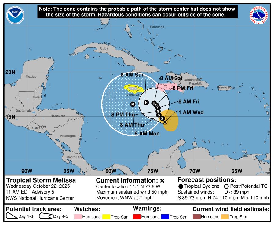
1/2 Taking a look at Melissa this morning. I don’t think there have been too many changes, although the 5 day model spread looks like it tightened a little. Here’s what the NHC is saying: ”With such a distinct track bifurcation [northeast or west] noted in the guidance…


October 22, 2025 at 12:41 PM
1/2 Taking a look at Melissa this morning. I don’t think there have been too many changes, although the 5 day model spread looks like it tightened a little. Here’s what the NHC is saying: ”With such a distinct track bifurcation [northeast or west] noted in the guidance…
Snuck up on me…a line of showers associated with a weak front moving through MS and AL. Shouldn’t be severe but maybe some thunder. These will fizzle before reaching the coast. The front will keep temps on the cool side for a few more nights.
October 21, 2025 at 4:09 PM
Snuck up on me…a line of showers associated with a weak front moving through MS and AL. Shouldn’t be severe but maybe some thunder. These will fizzle before reaching the coast. The front will keep temps on the cool side for a few more nights.
First official forecast for Tropical Storm Melissa. This will probably* not be an issue for the US, but the Florida Peninsula should keep an eye on it, lots of uncertainty still. Also, another reminder that the forecast cone DOES NOT represent forecast uncertainty for this specific storm.

October 21, 2025 at 3:01 PM
First official forecast for Tropical Storm Melissa. This will probably* not be an issue for the US, but the Florida Peninsula should keep an eye on it, lots of uncertainty still. Also, another reminder that the forecast cone DOES NOT represent forecast uncertainty for this specific storm.