Chris Fogarty, PhD
@cyclone-fogarty.bsky.social
1.1K followers 56 following 200 posts
Meteorologist/Manager at the Canadian Hurricane Centre @ECCC_CHC | Tropical cyclone (hurricane) and many weather related topics | postings are own not employer
Posts Media Videos Starter Packs
Reposted by Chris Fogarty, PhD
yhzweatherguy.bsky.social
Thanks to our citizen science volunteers for sharing rainfall data. While the Thanksgiving weekend is dry, later next week shows signs of the start of a somewhat damp period.
Bring it on!
cyclone-fogarty.bsky.social
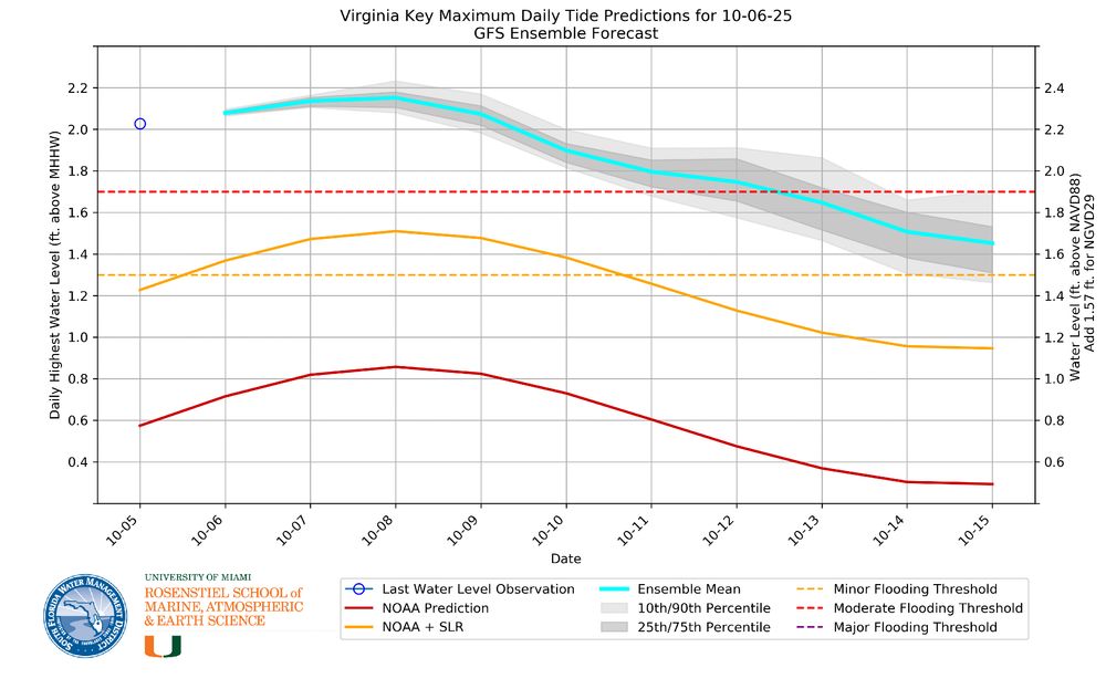
Am I reading the Virginia Key tidal timeseries correctly...is that a water level about 1 ft above general tide prediction?
cyclone-fogarty.bsky.social
Significant change in airmass ... Thursday much cooler with changing weather from hour-to-hour (and minute-to-minute in some cases). Cloud/sun/showers 'puffy clouds' ... could even see some 'graupel' (type of ice pellet) mixed in. #nswx #pewx
cyclone-fogarty.bsky.social
High-res weather model rainfall forecast from the cold front tonight (1st image) and from sea-effect cold showers in the NW winds behind it (2nd image). Some of the peak amounts may be overdone but gives an idea of pattern and areas to expect some drought relief. #nswx #pewx
cyclone-fogarty.bsky.social
Almost looks like a warm-core low trying to form over the relative warmth of the Great Lakes.
cyclone-fogarty.bsky.social
With the full moon being "largest" closest to earth this week, tides are extra high overall - even if local weather is pleasant. The impacts are most pronounced in places like Florida.
bmcnoldy.bsky.social
The significant ongoing tidal flooding event in the #Miami area is caused by a few coincident components:
1) the full moon on October 6, which happens to be near perigee (October 8)
2) sea level rise adds ~8 inches to the baseline sea level used in NOAA tide predictions

#KingTide
[1/2]
cyclone-fogarty.bsky.social
The drought effects did indeed seem discernible recently: bsky.app/profile/cycl...
cyclone-fogarty.bsky.social
The drought has been so pronounced that the effects are discernible in satellite imagery. Here is a comparison with mid September last year. Note the yellow/brown agricultural lands compared to generally greener ones a year prior.
cyclone-fogarty.bsky.social
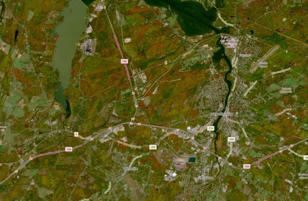
High-resolution Sentinel satellite views over New Glasgow and area - two cloudless snapshots: Aug 17 and today, Oct 6 showcasing the fall colors.
cyclone-fogarty.bsky.social
Nice plots Brain. What are some of the key roads/infrastructure around Miami area that are to likely be impacted by the 'moderate' flooding expected Oct 8?
cyclone-fogarty.bsky.social
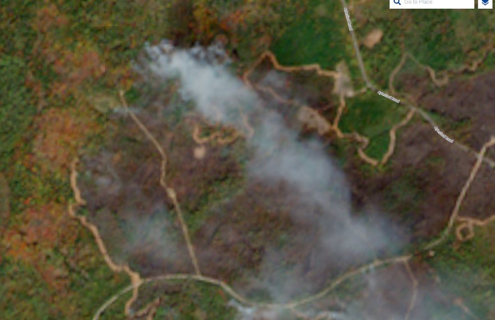
Normal conditions before fire/foliage change (Sept 2):
cyclone-fogarty.bsky.social
View of George Lake fire as of Saturday Oct 4. Note the fire break around edge by dozers (looks like winding logging road). Foliage color change apparent as well. #nswx
cyclone-fogarty.bsky.social
Noticed that as well on my stroll - here late. Took a couple snaps.
cyclone-fogarty.bsky.social
Low temperatures last night around Nova Scotia. Lows across PEI were in the 4 to 7C range. #nswx #pewx
cyclone-fogarty.bsky.social
Cooler airmass today ... this afternoon large cumulus cloud buildup and likely showers into evening with sunny intervals. Don't be shocked if you see some small hail (ice pellets) during the showers with temperature drop below 10C. Low freezing level around 4500 ft (1300m). #nswx #pewx
Reposted by Chris Fogarty, PhD
zoom.earth
#Humberto and #Imelda are so close to each other that their circulating winds cancel each other out in a calm “col” area in between them.

🇧🇲 Bermuda needs to be on alert however as Imelda will likely cause flash flooding and damaging waves from Wednesday into Thursday.
cyclone-fogarty.bsky.social
Clear as a bell out there today and quite warm. #nswx #pewx Temps in C. 25C = 77F.
cyclone-fogarty.bsky.social
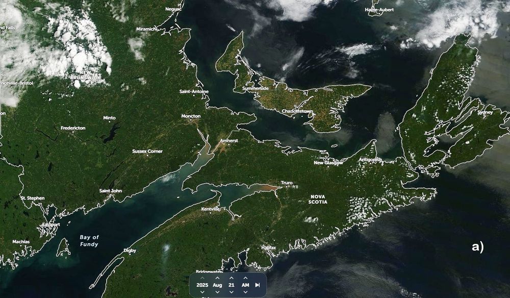
Comp of satellite imagery from a) late Aug '25 (before fall colors), b) late Sept '25 and c) late Sept '22. Presence of fall colors more prominent and earlier than normal ('22 was near normal) this year - possibly changing sooner due stress from drought and cooler/dry nights. #nswx #pewx #nbwx
cyclone-fogarty.bsky.social
Fine where it is if it keeps the storms away from land.
cyclone-fogarty.bsky.social
Jet stream steering them that way this year
cyclone-fogarty.bsky.social
Model forecast for middle of next week showing general position and possible cloud pattern associated with Hurricane Humberto and TD9/Imelda. Atlantic Canada not expected to have to contend with these storms, but will update if that changes.
cyclone-fogarty.bsky.social
Rainfall totals from recent weather system (mm). #nswx #pewx